A History of the County of Sussex: Volume 6 Part 3, Bramber Rape (North-Eastern Part) Including Crawley New Town. Originally published by Victoria County History, London, 1987.
This free content was digitised by double rekeying. All rights reserved.
'Bramber Rape (North-eastern Part)', in A History of the County of Sussex: Volume 6 Part 3, Bramber Rape (North-Eastern Part) Including Crawley New Town, (London, 1987) pp. 1-4. British History Online https://www.british-history.ac.uk/vch/sussex/vol6/pt3/pp1-4 [accessed 26 April 2024]
BRAMBER RAPE (North-eastern Part)
THE NORTH-EASTERN part of Bramber rape, like the north-western, lies across varied geological strata. The chalk downland in the south rises to c. 700 ft. along its steep north-facing scarp, and is characterized by dry valleys which run southward to the sea. Further north are sands and clays. A narrow band of Upper Greensand immediately north of the South Downs was a site for early settlement. The Lower Greensand a few miles further north forms east-west ridges which provide other settlement sites; the ridges have steep sides in Henfield, and in Albourne yield rolling country. Much of the northern portion of the area lies on the Weald clay, a region of gentle undulation containing outcrops of Horsham stone, as further west. Flanked to north and south by the clay, and forming a western extension of the High Weald of East Sussex, is the area of older sandstones and clays, rising to c. 500 ft., most of which lay historically within St. Leonard's Forest. The south is drained by the river Adur and its tributaries; the river forms a wide valley between Henfield and Upper Beeding, where winter flooding remained frequent in the 20th century. St. Leonard's Forest is the watershed between the Arun, flowing west, and the Mole, flowing north-east towards the Thames.
The southern end of the area is characterized by relatively little tree cover, but the Weald clay country formerly bore thick woodland which is commemorated in many place names. Many shaws, or belts of woodland between closes, survived in 1986. (fn. 1) St. Leonard's Forest, despite the modern connotations of its name, seems in the Middle Ages to have been divided roughly equally between woodland and heath; heathland later came to predominate in the 17th and 18th centuries, and the largely wooded appearance of Lower Beeding parish in the late 20th century is chiefly due to afforestation since c. 1800. Unlike Ashdown Forest in Pevensey rape, St. Leonard's Forest was not much subject to rights of common pasture. There was parkland in the Middle Ages, both there and elsewhere, for instance in Ifield, Henfield, and Albourne. Common or former common land, much of it used for recreation, remained in 1986 in Ifield, where some was wooded, and in Henfield.
The well drained sandstone country in the south had many settlements in the late 11th century, some already with churches. Much of the north belonged to manors further south during the Middle Ages, supplying detached pasture, especially for swine, and timber. Shermanbury had separated from what was apparently its parent manor of Kingston by Sea by 1066, and Sedgewick from Broadwater by the 13th century, though Broadwater parish retained a detached part at Sedgewick until the late 19th century. Lower and Upper Beeding similarly formed two parts of one parish until the early 19th century; no land, however, in Lower Beeding, the wealden portion, is known to have been held of Beeding manor. Much of Cowfold parish once belonged to Beeding manor, and the so-called manor of Cowfold was merely the land of Beeding manor in that parish. There was no manor of Nuthurst, and the manor of Rusper was not the most important in its parish; much land in both parishes belonged originally to Steyning manor and was later held of its wealden offshoot, Shortsfield in Horsham.
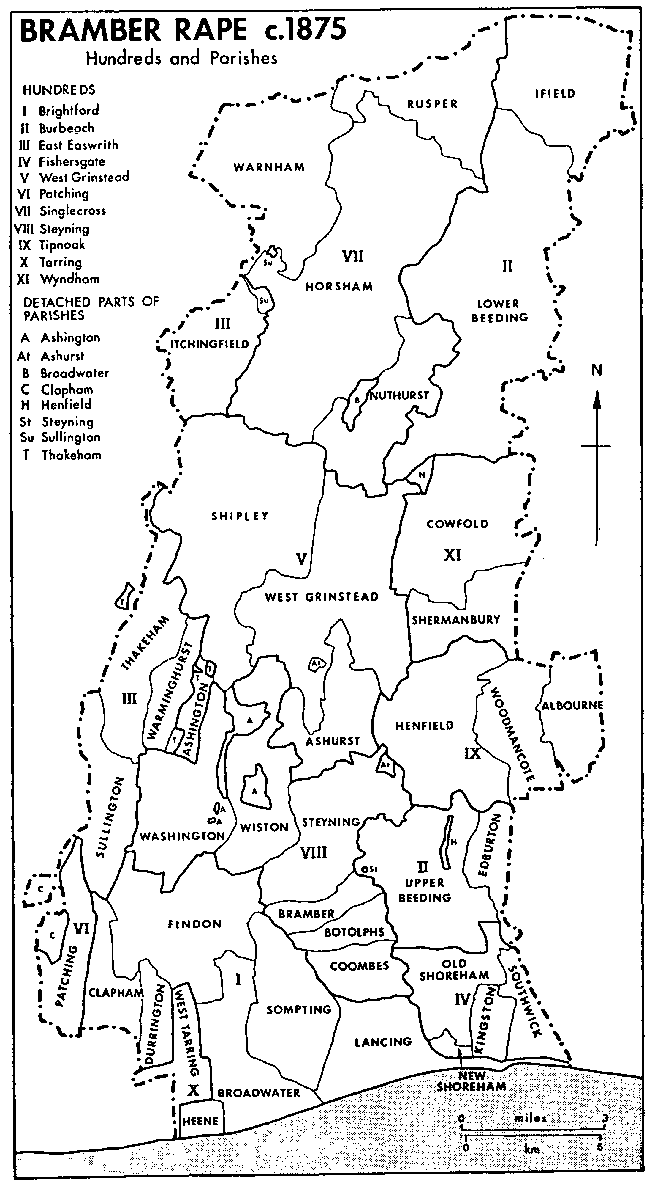
Bramber Rape c.1875
Hundreds and Parishes
Settlement in the northern two thirds of the area was chiefly scattered in the Middle Ages, with nucleation developing later. Many medieval houses or sites of medieval houses are known. (fn. 2) There is little or no evidence for medieval settlement near the churches of Albourne, Cowfold, or Ifield, while at those of Woodmancote and Shermanbury it is unlikely that there ever was a nucleated settlement; the chief settlement in Woodmancote parish was at Blackstone. A nucleated settlement on the site of the modern Rusper village may be indicated in 1299, and at Nuthurst in 1328. The modern village at Albourne may have been deliberately planned, perhaps in the late Middle Ages. Despite much evidence for a prehistoric presence in St. Leonard's Forest, there were very few settlers there in the Middle Ages; most houses were built in the 19th and 20th centuries, when the village of Lower Beeding and the hamlets of Colgate and Crabtree grew up. The process of 19th-century settlement in Lower Beeding, with the creation of new parishes and building of churches, was essentially similar to that which obtained in medieval times elsewhere. Other parishes too by the 19th century had one or more hamlets besides their main settlement.
Edburton in the south saw a decline of population in the 19th century and early 20th, but the combination of nearness to London, good road and rail communication, attractive scenery, and the easy availability of sport, brought many newcomers to settle in the rest of the area after c. 1770. South-facing ridges, for instance in Ifield, Rusper, and Nuthurst, were popular. Some very large houses were built, while the landscape was tamed by the laying out of many parks and gardens, notably those at Sedgewick Park in Nuthurst and Leonardslee in Lower Beeding. In Lower Beeding the influx of new landed gentry did much by c. 1880 to redeem the parish from its former wild and lawless reputation. Less wealthy immigrants were more numerous, especially in the 20th century. Some rural settlements expanded greatly after the Second World War, Upper Beeding accommodating many first-time house buyers, Henfield many retired people, and Mannings Heath in Nuthurst many workers in London, Horsham, and Crawley.
Market facilities and specialized goods and services were provided in the past by towns outside the area: Steyning and Shoreham in the south, and Horsham in the north. The only larger settlements before c. 1850, offering some urban functions, were Henfield and Crawley, the latter apparently a medieval 'new town' which straddled the boundary both of the rape and of Ifield parish. Both places expanded after c. 1850 with the arrival of the railway, but while Henfield remained an enlarged village in 1986, Crawley by c. 1920 had become a town in all but local government status. After its designation as a new town in 1947, it grew rapidly to reach a population of 72,684 in 1971, the built-up area later spreading into Lower Beeding.
There were numerous open fields and furlongs in Upper Beeding and apparently in Edburton in the Middle Ages, but further north the evidence for open-field agriculture is slight, the best relating to Shermanbury. In the north St. Leonard's Forest contained some agricultural land in the Middle Ages, but in the 17th and 18th centuries was chiefly used for rearing rabbits. Much land there was converted to tillage in the early 19th century. In the later 19th century and the 20th pasture came to dominate over arable in the area as a whole, the Adur valley pastures in Henfield and Upper Beeding being especially highly regarded. Market gardening and fruit and flower growing also expanded greatly in the same period on favourable soils.
Non-agricultural economic activities in the past included saltmaking in the Adur valley, ironworking in and around St. Leonard's Forest, quarrying for sand or stone from the Lower Greensand and Horsham stone outcrops, and brickmaking, especially in Lower Beeding and Henfield. In the south the river Adur provided fisheries; the cement works at Upper Beeding was a major employer in the 20th century. In the north, woodland industries were prominent. Both Henfield and Crawley had manufactures in the 19th century; at Crawley they increased in importance in the early 20th. In 1986 Crawley provided industrial and office employment for a large hinterland, and there were also industrial estates in Henfield, Upper Beeding, and at Holmbush in Lower Beeding. Gatwick airport (within Crawley after 1974) profoundly affected both employment and environment in the northern part of the area from the late 1950s.
Much land in the Middle Ages belonged to the church, especially to the two religious houses which lay within the area, Rusper and Sele priories, to the Norman abbey of Fécamp, and to the bishop and the cathedral of Chichester, the bishop having an important house at Stretham in Henfield. Other major medieval landowners were the Braoses and Mowbrays, successive lords of the rape, and the Poynings family of Poynings. In the 16th and 17th centuries the chief local landed families included the Gratwickes, Coverts, Carylls, and Shirleys. In the 19th century the Broadwoods and the Hursts owned much of the northern part of the area.
Roads from London to Steyning and Shoreham traversed the area from north to south in the Middle Ages. After the mid 18th century the main southern destination was Brighton. In the late 18th century and early 19th Henfield lay on one of the chief coaching routes to the resort, but the main Brighton road in later times passed through Crawley and Albourne; both places had important inns, though Albourne village itself was bypassed. A western bypass for Crawley was constructed in the 1930s; it was succeeded in the 1970s by a section of the London-Brighton motorway (M 23) east of the town. The chief east-west road of medieval Sussex, that between Chichester and Lewes, passed through the south end of the area, but east-west communication in the north was poor before the 19th century. In the south there was no road-crossing of the river Adur in 1986 between Upper Beeding and Shermanbury, but the river in the past was itself an important route, with wharves at both Beeding and Henfield. The north was traversed by the Three Bridges to Horsham railway, opened in 1848, and the south-west corner by the Horsham-Shoreham railway, opened in 1861.
The scattered character of settlement fostered Dissent, for instance in Nuthurst and Woodmancote, and there have been Quakers in Ifield apparently continuously since the 1650s. Recusancy was less widespread, but two notable Roman Catholic religious houses were built in the 19th century, the Capuchin friary at Crawley in Ifield parish, and the Carthusian monastery at Parkminster in Cowfold; the latter survived in 1986. Non-Christian religions were represented in Crawley new town after c. 1970.
One London draper had real estate in Rusper and Ifield, presumably as an investment, in the late 14th century; (fn. 3) another London merchant seems to have retired to Rusper in the mid 16th. (fn. 4)