A History of the County of Somerset: Volume 6, Andersfield, Cannington, and North Petherton Hundreds (Bridgwater and Neighbouring Parishes). Originally published by Victoria County History, London, 1992.
This free content was digitised by double rekeying. All rights reserved.
'Stogursey', in A History of the County of Somerset: Volume 6, Andersfield, Cannington, and North Petherton Hundreds (Bridgwater and Neighbouring Parishes), (London, 1992) pp. 130-136. British History Online https://www.british-history.ac.uk/vch/som/vol6/pp130-136 [accessed 19 April 2024]
STOGURSEY
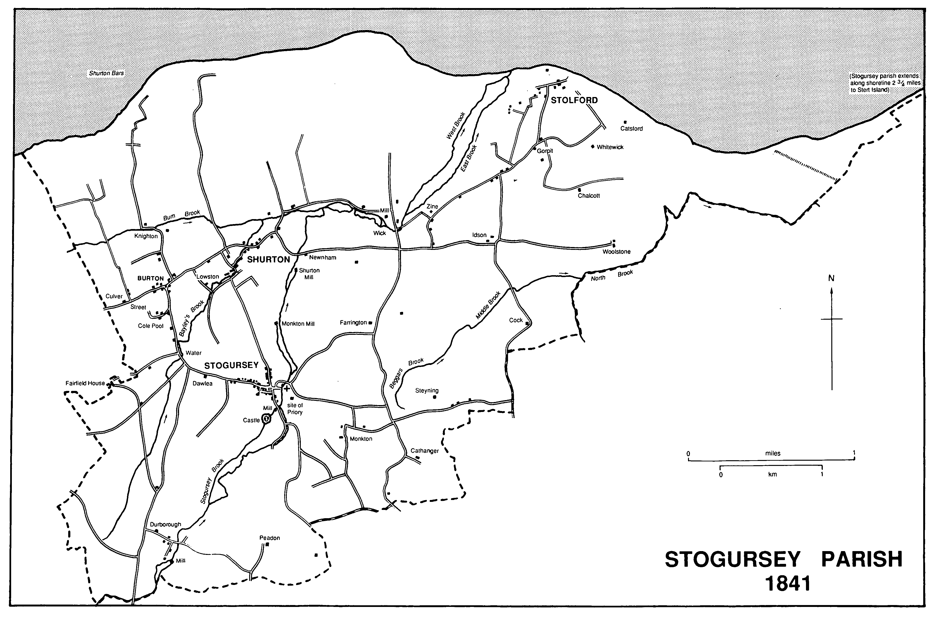
Stogursey Parish 1841
Stogursey is a large parish on the Bristol Channel coast west of the river Parrett. It includes the substantial village and former borough of Stogursey, with its castle and priory, and a number of hamlets of which the largest are Shurton, north of Stogursey village, and Stolford, on the coast, and Hinkley Point nuclear power station. (fn. 1) The name, in the 11th century Stoche or Estocha, (fn. 2) acquired the suffix Curci from its owners in the later 12th century. (fn. 3) The ancient parish was shaped like an inverted triangle whose base lay along the coast, its apex 5.5 km. inland. East of Stolford it tapered to a narrow coastal strip largely confined to the foreshore but including at its eastern end part of Steart common on the promontory at the mouth of the Parrett. That promontory continued north-east to Steart warren until the peninsula was breached c. 1798, to form Stert Island. (fn. 4) The island was transferred from Stogursey to Huntspill parish in 1885. (fn. 5) The coastal strip remaining in the parish was either lost to the sea by coastal erosion or absorbed into Otterhampton parish. The present civil parish measures 2,414 ha. (5,965 a.). (fn. 6)
The inland boundaries are irregular. Much of the parish lies on low, undulating land near the 15-m. contour, watered by Bum, Bailey's Stogursey, and Middle brooks, and comprising Blue Lias and alluvium, with areas of brown loamy and silty sands with some gravel around Fairfield, Burton, Shurton, and Stolford. Higher ground to the south, comprising marls known as Mercia Mudstone, reaches above the 61-m. contour at Tet Hill, Monk wood, and Farringdon Hill, and above the 76-m. contour near Durborough. There are bands of marls north of Knighton, and Catsford and Wall commons are on deposits of Storm Gravels. (fn. 7) Marl was used for dressing land at the end of the 13th century. (fn. 8) There was a location named Claypits at Durborough in the later 14th century (fn. 9) and the clay was used by potters there in the 15th. (fn. 10) Limestone, found at the junction of marls and lias, was quarried for building in and near Stogursey village from the 15th to the 18th century (fn. 11) and elsewhere it was dug for burning in the 17th century. (fn. 12) There was a kiln on the coast near Shurton Bars in the 18th century (fn. 13) and the limestone there was described as valuable. (fn. 14) In the later 19th century there were five kilns near Shurton Bars and two inland near Steyning. (fn. 15) The name Sandpits, found south of Stogursey village in the early 18th century, presumably indicated extraction there, (fn. 16) and in the mid 19th century there was a field called Brick Yard at Knighton. (fn. 17) In 1792 coals, probably sea coal, were said to have been discovered, also near Knighton. (fn. 18) In 1909 the Bridgwater Collieries Co. Ltd. leased mining and mineral rights on Sir Alexander Acland-Hood's lands in Stogursey but the lease was surrendered in 1911. (fn. 19) Gravel was quarried in several places in the parish, and beach pebbles were used for road repairs. (fn. 20)
On the beach near Stolford are the remains of a submerged forest dated to 2500 B.C., part of the evidence for a coastline constantly changing since prehistoric times. (fn. 21) In 1614 the bounds of Wick manor could not be perambulated because of coastal erosion, although there were sea walls which lord and tenants were supposed to repair. (fn. 22) Those defences frequently failed to protect coastal cottages (fn. 23) and in the 1660s Steart common was said to be liable to flood almost as far as Steart House. (fn. 24) A proposal to cut a channel through the promontory west of Steart village in 1723 (fn. 25) was not accepted, but changes continued, notably the breach of c. 1798, (fn. 26) until modern sea defences were built in the late 1950s. They involved the construction of a sea wall and the consolidation of soil with Spartina grass. Stert Island and the Stogursey foreshore became part of the Bridgwater Bay National Nature Reserve in 1954. (fn. 27)
There is evidence of Bronze Age and Roman occupation in the parish, much of the prehistoric material found near the present shore line. (fn. 28) The higher ground to the south and south-east had attracted a number of settlements by the later 11th century, several sharing the element 'stoche' in their names. (fn. 29) Stochelande (later Shurton, from 'sheriff-tun'), (fn. 30) Estochelande (probably the later Steyning), Estocha, and Suntinstoch (representing the later Stogursey village) may have been formerly parts of a single unit, and Durborough, Idson, 'Sedtammetone', Woolstone, and Wyndeats had also been settled by the later 11th century. (fn. 31) Fairfield and Wick, both hamlets established by the 13th century, were later known like Shurton and Stogursey to have had their own arable fields. (fn. 32) There were also houses at Burton, (fn. 33) Cock, (fn. 34) Culver Street, (fn. 35) Lowston, (fn. 36) Knighton, (fn. 37) and Monkton by the mid 14th century, the last named from the priory founded after 1100. (fn. 38) Other settlements include West Wall, later Wallsend, recorded in 1423, (fn. 39) and Stolford in 1431-2. (fn. 40) By 1614 Wick and Stolford each comprised several houses, (fn. 41) and Durborough was still a hamlet in the mid 18th century (fn. 42) although by the 19th it had been reduced to a single farm. (fn. 43) After 1614 cottages were lost along the coast at Stolford and Wallsend, (fn. 44) and others were abandoned at Shutternford, also known as Fairfield village, (fn. 45) and at Wick. (fn. 46) In the 1840s there was some new building at Shurton, (fn. 47) and roadside settlement increased along the Combwich road beyond Steyning. (fn. 48)
Stogursey village lies at the junction of two ancient routes, one between the Quantocks and the coast, the other from the river crossing at Combwich. East of the junction and beside a brook a church is known to have existed by the early 12th century. (fn. 49) Upstream, south of the junction, Stogursey castle was built by 1204, and probably by 1166 in succession to a building of the early 12th century. (fn. 50) At the convergence of the two routes a market place was formed, perhaps in the 12th century, and a borough had been created by 1225 (fn. 51) bounded by a watercourse fed from St. Andrew's well and known as the Town Ditch or Law Ditch, part of which still runs on the south. (fn. 52) There were said to be 60 burgages in 1301. (fn. 53) The borough seems to have extended beyond the ditch by the later Middle Ages, northwards along Lime Street and westwards along High Street, where building plots were fitted into the strips of the adjoining common arable fields. (fn. 54) In 1614 there were over 80 burgages. (fn. 55) By the end of the 18th century the borough included three open-field furlongs, called burgages, and other adjoining fields. (fn. 56)
A large, rectangular market place was formed at the centre of the borough, entered from the east via Harpe Lane, so named in 1440, and St. Mary Street (fn. 57) (renamed Church Street c. 1861). (fn. 58) Routes from the north converged on Lime Street, so named in 1431, (fn. 59) and from the west on High Street, recorded in the early 16th century. (fn. 60) From the south, a road passing the castle and the castle mill was called Castle Street in 1431 (fn. 61) and Mill Street in the 19th century. (fn. 62) Encroachments on the market place had probably begun by the 15th century when the almshouse occupied part of an island site in the north-eastern corner. (fn. 63) By 1614 there was a larger group of buildings on the south side. A grid of streets was thus formed. The widest street, to the north, was known as Fore Street at its wider, western end, and probably as East Street at its east end in the early 16th century. (fn. 64) In the centre, south of the almshouse, was Alms Street or Middle Street (fn. 65) and in the south Back Street. (fn. 66) Well Street, recorded in the early 16th century, (fn. 67) led to St. Andrew's well. Part of it was called St. Andrew's Street by 1871, (fn. 68) a name extended to Back and Well streets by the later 20th century.
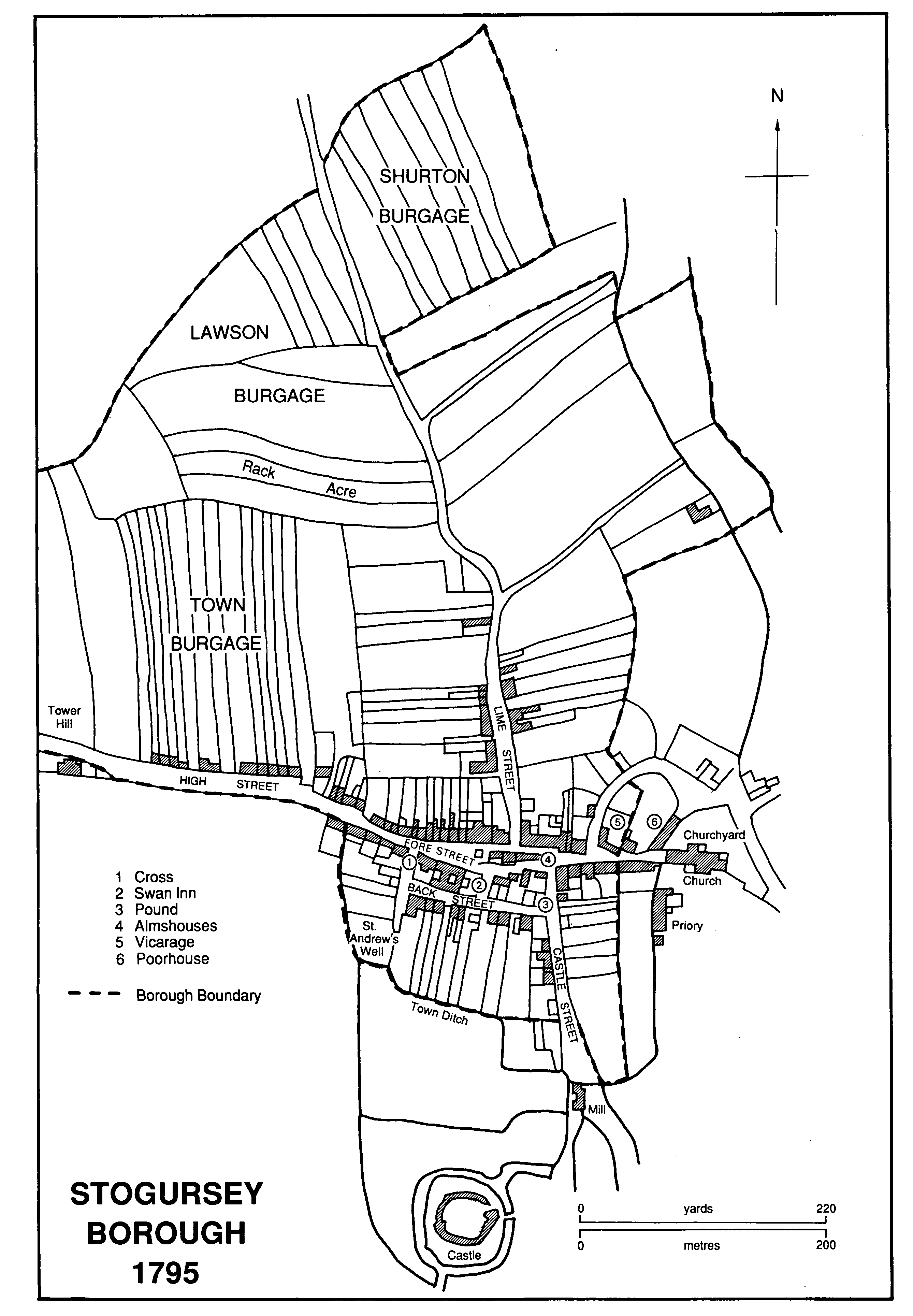
Stogursey Borough 1795
In 1865 the Combwich road was diverted from its course west of the old vicarage through the site of the church house around the churchyard. (fn. 69) At about the same time Sir Peregrine Acland bought the almshouse and the adjoining buildings (fn. 70) and demolished them leaving the site open. Courts were built off Well and Lime streets in the later 19th century; (fn. 71) in the later 20th new housing was sited in the former open fields north of the village.
The cross at the western end of the market place survives only as the worn stump of an octagonal shaft on a square plinth. It dates from the 13th or the 14th century. (fn. 72) St. Andrew's well was so named by 1473. (fn. 73) A garden was associated with it in 1532 (fn. 74) and the well lake was mentioned in 1614 (fn. 75) and 1742. (fn. 76) During the later 18th century the well heads were enclosed and the water was piped. In 1870 the area was enclosed and an arched entrance built bearing the arms of Acland and Egmont, the latter transferred from the 18th-century well house. The wells were restored in 1979 and consist of two well houses and three outlets with stone troughs. (fn. 77)
Most of the 100 a. of woodland on the Stogursey estate in 1086 was probably on the Quantocks in Over Stowey; only small areas were recorded at Durborough, Idson, Shortmansford, and Shurton. (fn. 78) Kete wood, later Cat wood, between Stogursey and Steyning, was mentioned in 1258-9, (fn. 79) and Monk wood, west of Cat wood, in 1378. (fn. 80) There were c. 130 a. of woodland at Fairfield in the 18th century, (fn. 81) but Little Fairfield wood (12 a.) was felled, possibly in the 1780s, (fn. 82) and Great Fairfield wood perhaps at the same time. Both were converted to tillage although chestnut, beech, fir, and oak standards were retained. (fn. 83) Great Fairfield wood had been replanted by 1840 and small plantations had been established around Fairfield House and lodges. The total of c. 138 a. of woodland in the parish in 1840 included Monk wood and copses at Wick park. (fn. 84) In 1905 there were 147 a. of woodland in the parish. (fn. 85)
There was a park near the castle in 1295. (fn. 86) The land, known as Old Park and later part of the Wyndeats estate, continued to be called the park or the king's park into the 16th century. (fn. 87) Field names indicate its position west of the castle site. (fn. 88) Wick park, north-east of Stogursey village, measured 120 a. in 1301. (fn. 89) Part of the area was wooded and income was received from timber and pannage. (fn. 90) The maintenance of its fence was the responsibility of tenants of adjoining land. The park was divided and let for agricultural use by the late 16th century, (fn. 91) and in 1681 it was sold to the owners of the Steyning estate. (fn. 92) By 1840 it was partly shared between several farms and partly woodland. (fn. 93) The names Wick Park covert and Wick Park cottages indicate the position of the park south-east of Wick hamlet. William Verney is said to have been licensed to enclose 200 a. for a park at Fairfield in 1473 (fn. 94) and a deerpark there was referred to in 1516. (fn. 95) Much of the parkland around the house by 1822 was outside Stogursey parish, but within the parish was an area south of the house which had been emparked by Sir John Acland when the road to Stringston was diverted away from the house between 1806 and 1822. (fn. 96)
The route from the Parrett crossing at Combwich may originally have passed south of Stogursey village and near the castle site; it presumably ran near Steyning, and beyond Peadon westwards it is traceable as a green way north of Durborough. (fn. 97) That route from Combwich may in the 12th century have been diverted northwards to Stogursey village when the market was established there, (fn. 98) and may have continued to Shurton and along the remarkably straight road via Burton and Culver Street to Lilstock, Stringston, and the coast road to Watchet. A second route from Stogursey market place passed via Fairfield to Holford, along a road still known in the 20th century as Portway Lane. (fn. 99) Portway Lane led both to Watchet and to the Quantocks. A more direct route to Over Stowey from Burton through Durborough was known in the later 18th century as the great road from Stogursey to Stowey. (fn. 100) A new route, made necessary by the construction of Hinkley Point nuclear power station, comes from Cannington and runs across the site of Wick park.
In 1824 a ship canal was proposed, and a route surveyed by Thomas Telford linking Stolford with Beer (Devon). (fn. 101) A rail link between Stolford and Bridgwater was suggested in 1845. (fn. 102) In 1888 a ship canal between Lilstock and Seaton (Devon) via Stolford was supported by the Board of Admiralty. (fn. 103) A railway between Bridgwater and Stogursey, with an extension further west, was under consideration for several years after 1899. (fn. 104)
In 1957 building began on a nuclear power station for the Central Electricity Generating Board at Hinkley Point, a site on the coast almost due north of Stogursey village and formerly known as Botestall. (fn. 105) Generating began in 1965. A second station on the site, opened in 1976, had the first advanced gas-cooled reactor to supply the national grid. The two stations have a combined output capacity of 3,400 megawatts and 1,300 people are employed on the site. (fn. 106) A third station was proposed in 1985 and was the subject of a public inquiry in 1989-90.
There were two licensed victuallers in 1608 (fn. 107) and an unlicensed house was suppressed in 1614. (fn. 108) By 1630 the number of licensed premises in the parish had increased to four (fn. 109) and in 1647 the number in the borough alone was reduced to three. (fn. 110) Included was the Swan, named in 1622 and probably in existence by 1619, (fn. 111) which stood in Stogursey market place. Its name was changed to the Acland Arms c. 1865 (fn. 112) and to its present name, the Acland Hood Arms, by 1889. (fn. 113) It remained open in 1985. By 1675 and for most of the 18th century there were six licensed houses, including the Corner Inn at the junction of Church and Castle streets, first recorded in 1654, which was called the Three Choughs by 1713 (fn. 114) and the Queen's Head by 1744. (fn. 115) The White Horse, east of the last, had opened by 1673. (fn. 116) The Lamb, probably in business between 1746 and 1786, and the Rose and Crown, possibly in Castle Street and named in 1754, (fn. 117) did not survive into the 1790s. There was then only one licensed house in the parish, and during the unrest of 1800-1 the men of Stogursey complained that there were no more. (fn. 118) In the mid 19th century several beerhouses came into being (fn. 119) and by the later years of the century there were c. 10 public houses, including the Greyhound (fn. 120) and the White Lion (fn. 121) in Lime Street, the Fox and Hounds (fn. 122) in High Street, and the Castle in Castle Street. (fn. 123) The Greyhound was still in business in 1985.
The earliest recorded public house outside the village was Steart House, on Steart warren, which was licensed between 1779 and 1792. (fn. 124) The Burton inn was licensed in 1850 (fn. 125) and remained open in 1939. (fn. 126) It probably closed soon afterwards and was a private house in 1985. There was a beerhouse at Stolford, possibly at the junction of Gorepit and Whitewick lanes, between 1850 and 1861. (fn. 127) The beerhouse at Cockwood was open between 1851 and 1872. (fn. 128) The Shurton inn was probably open from 1861 (fn. 129) and remained open in 1985. Another beerhouse at Shurton, at the east end of the hamlet, was open by 1871 (fn. 130) and possibly by 1851. (fn. 131) By 1890 it was known as the King Tree, and is said also to have been called the First and Last. (fn. 132) It probably closed soon after 1906 (fn. 133) and in 1985 was called Lower House Farm.
The Stogursey Women's friendly society was established in 1806 and met at the Swan. It provided pensions for members over 70 and there were initially 51 members. (fn. 134) It was dissolved in 1868. (fn. 135) The Stogursey friendly society had been founded by 1811 and also met at the Swan. (fn. 136) It was disbanded, probably in 1845, when the Stogursey New friendly society was formed with over 100 members. The society ceased to take new members c. 1920 and was wound up in 1952 when 17 surviving members each received c. £34. (fn. 137) Painted 'battle boards', possibly belonging to the Stogursey friendly society, are preserved in the parish church. (fn. 138)
There was a reading room and library in Church Street in 1872, (fn. 139) and in 1928 both old and new reading rooms were mentioned. (fn. 140) They were not recorded again. A maypole was erected in the village in 1764, (fn. 141) and mummers performed in the early 19th century. (fn. 142)
In 1340 the borough was taxed at 30s., more than twice Nether Stowey. In 1377 130 people paid poll tax. (fn. 143) There were 646 communicants in 1548, the total probably including the communicants of Lilstock, (fn. 144) and in 1563 there were 174 households in Stogursey alone. (fn. 145) In 1801 the population was 1,168. The figure rose to 1,496 in 1831 and remained fairly constant until 1881, when it fell to 1,262. The decline continued, reaching 1,034 in 1901, but in the later 20th century new housing brought about an increase. By 1961 the population was 1,391. It rose to 1,454 in 1971 but by 1981 had fallen to 1,196. (fn. 146)
King John stayed at Stogursey in September 1210 with Warin FitzGerold, possibly at the castle. (fn. 147) Sixty-three men were fined for involvement in the Cornish rebellion in 1497. (fn. 148) Two supporters of the duke of Monmouth were executed at Tower Hill, probably on the site now occupied by the school. (fn. 149) The cross was the site of a Jacobite disturbance in 1719. (fn. 150) In 1801 men from Stogursey marched to Bridgwater to ask for lower prices. (fn. 151) Sir John Burland of Steyning (d. 1776) was Chief Baron of the Exchequer. (fn. 152) Sir Wroth Palmer Acland (d. 1816) was a younger son of Arthur Acland of Fairfield and served under the duke of Wellington, becoming K.C.B. and Lieutenant-General in 1814. (fn. 153) Samuel Taylor Coleridge wrote his 'Ode to Sara' at Shurton Bars in 1795. (fn. 154) The emperor of Abyssinia, Haile Selassie, visited Stogursey in 1938. (fn. 155)