A History of the County of Somerset: Volume 6, Andersfield, Cannington, and North Petherton Hundreds (Bridgwater and Neighbouring Parishes). Originally published by Victoria County History, London, 1992.
This free content was digitised by double rekeying. All rights reserved.
'Durston', in A History of the County of Somerset: Volume 6, Andersfield, Cannington, and North Petherton Hundreds (Bridgwater and Neighbouring Parishes), (London, 1992) pp. 257-259. British History Online https://www.british-history.ac.uk/vch/som/vol6/pp257-259 [accessed 26 April 2024]
DURSTON
The parish of Durston, on the southern edge of North Petherton hundred, lies 7.5 km. northeast of Taunton. (fn. 1) Roughly oval in shape, it measures 2.4 km. from east to west and 1.5 km. from north to south at its widest point. A detached part of the parish, lying 1 km. beyond the eastern boundary in North moor between Lyng and North Petherton and known as Priestwood (32 a.), was transferred to Lyng in 1888. (fn. 2) In 1891 and later the parish measured 1,013 a. (410 ha.). (fn. 3)
The parish lies on undulating ground where the lowest slopes of the Quantocks descend to the valley of the Tone at Curry moor. Its northern boundary is marked by a stream and its south-eastern by a watercourse called Old Rhyne, which marks the end of Curry moor. A stream runs southwards between the highest ground to the west, rising to 47 m., and a small central ridge, from which the land falls eastwards to another stream running into the Old Rhyne. Most of the parish lies on Keuper marl, with a small area of Upper Sandstone in the extreme north-west, valley gravels in the south, and a narrow tongue of alluvium along the course of the eastern stream. (fn. 4) Limestone was quarried for a few years from 1650, possibly at a site later called Quarry close on the western edge of the parish, (fn. 5) and red sand was dug in the 1870s. (fn. 6)
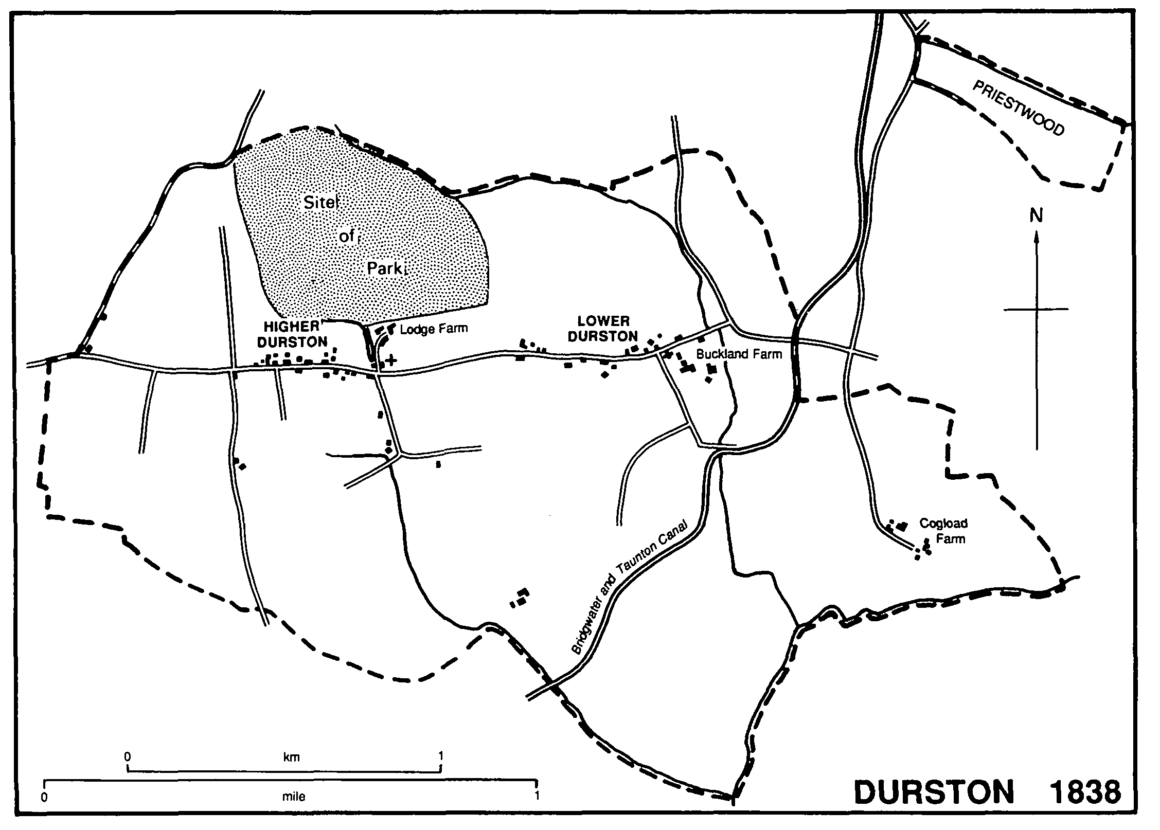
Durston 1838
The Taunton-Glastonbury road, turnpiked by the Taunton trust in 1752, (fn. 7) runs from east to west through the centre of the parish, entering near Durston Elms. There a road north to West Newton forms part of the western boundary; another runs south to Creech St. Michael, a modern replacement for an earlier route south from Walford Cross which was blocked in 1973 by the construction of the M5 motorway. Lanes and footpaths lead from the central spine road to the fields, including Curry Lane to Creech St. Michael and Frog Lane. At the extreme eastern edge of the parish Primmore Lane leads north towards North Petherton; Priestwood Lane leads north-east to the detached part of the parish at Priestwood. (fn. 8) Another lane leads south from the main road to Cogload. The main road was widened in the 1960s.
The Bridgwater and Taunton canal, running through the south-eastern part of the parish, was opened in 1827. It is crossed by two bridges, Headworthy and Swan's Neck, to provide access to fields. The canal was virtually unused commercially after 1892. (fn. 9) The Bridgwater and Taunton section of the Bristol and Exeter railway, entering the parish beside the canal and running roughly parallel with it, was under construction in 1841 (fn. 10) and was completed the following year. Durston station, however, lay in Lyng parish. A loop from Athelney was brought to a junction at Cogload in 1906 as part of the new London route through Castle Cary, a junction modified in 1931. (fn. 11)
The two principal settlements, Higher and Lower Durston, line the Taunton-Glastonbury road. Higher Durston, around the junction with Frog Lane and a path to West Newton, includes the church, Lodge Farm (the former manor house), the former school, and the Buckwell, the latter a source of water mentioned in 1651 (fn. 12) and fed in the 19th century from a long narrow lake beside Lodge Farm. Lower Durston lies near the site of Buckland priory and preceptory and seems to have been known as Crosse by Buckland. In 1391 it comprised at least 16 messuages occupied by craftsmen such as a tanner, a smith, a skinner, and a barber, perhaps suggesting an attempt to plant an urban settlement outside the gates of the priory. (fn. 13) Cogload Farm, on the eastern edge of the parish, occupies the site of a hamlet established by the later 13th century. (fn. 14) Its name suggests that it was near a significant watercourse, (fn. 15) presumably the Old Rhyne which may thus mark the original course of the River Tone. There were several farmsteads there in the mid 18th century. (fn. 16)
Cogload Farm is a building of the 16th century or earlier with jointed crucks and two curing chambers. Froglane Farm, much altered in the 19th century, formerly had a smoke-blackened roof and Yardside, also in Frog Lane, is of three-roomed plan, with hall chimney against the screens passage. (fn. 17) Hascolls Farm, Lower Durston, dates from c. 1650. Maytree Cottage, Higher Durston, was formerly a tollhouse built c. 1850 at Walford Cross, West Monkton, and removed to its present site c. 1874. (fn. 18)
The site of Buckland priory and preceptory appears to be occupied by the farmhouse and buildings of Buckland Farm. (fn. 19) A spring rising north of the site fed fishponds established in the later 12th century and then supplied the priory with water and drainage. (fn. 20) The ponds, equipped with a boat in 1540, (fn. 21) were filled in by 1725, (fn. 22) but were in use as ponds in 1985. The water supply was channelled from a conduit by the 1260s, (fn. 23) the conduit standing in a field variously known as Flaggy or Flagons Chapel. (fn. 24)
The shapes of fields in the south-west part of the parish suggest the former existence there of a common arable field. (fn. 25) In the south-east part lay medieval meadow around Cogload. (fn. 26) Buckland manor in 1544 (fn. 27) included 20 a. of woodland, part known as Perifield grove, perhaps giving its name to Perry Ville farmstead, (fn. 28) later Perryville Barton.
A medieval park was formed north of Durston manor house c. 1223 and was stocked from Blackmore forest (Dors.). (fn. 29) Timber from the part was used to build a hall and solar at North Petherton in the early 14th century. (fn. 30) The park was said to have comprised 200 a. of wood and 60 a. of meadow in 1434. (fn. 31) The park survived as a separate farm into the later 17th century, (fn. 32) but was later incorporated into Lodge farm. Woodland called Buckland warren was referred to in 1695, (fn. 33) and a small field called Warren Kennel lay on the eastern side of the parish. (fn. 34) By 1838 it formed two small enclosures known as Warrens Plot and Kennel Plot, (fn. 35) both then tithe free because formerly part of Buckland priory estate.
There was an inn in the parish by 1613, (fn. 36) probably the inn at Buckland which in 1686 offered a single guest bed and stabling for two horses. (fn. 37) It was known as the Buckland inn by 1696, (fn. 38) and continued in use throughout the 18th century. (fn. 39) It was apparently pulled down between 1821 and 1828. (fn. 40) Another inn was opened by 1841 (fn. 41) which by 1866 was called the Durston inn. (fn. 42) It occupied the house known in 1985 as Mountlands in Lower Durston, and ceased to be an inn after 1883. (fn. 43)
In 1801 the population of Durston was 169. It rose to 258 in 1851 but thereafter declined in almost every decade. In 1981 the usually resident population was 108. (fn. 44)