A History of the County of Somerset: Volume 6, Andersfield, Cannington, and North Petherton Hundreds (Bridgwater and Neighbouring Parishes). Originally published by Victoria County History, London, 1992.
This free content was digitised by double rekeying. All rights reserved.
'Thurloxton', in A History of the County of Somerset: Volume 6, Andersfield, Cannington, and North Petherton Hundreds (Bridgwater and Neighbouring Parishes), (London, 1992) pp. 318-319. British History Online https://www.british-history.ac.uk/vch/som/vol6/pp318-319 [accessed 23 April 2024]
THURLOXTON
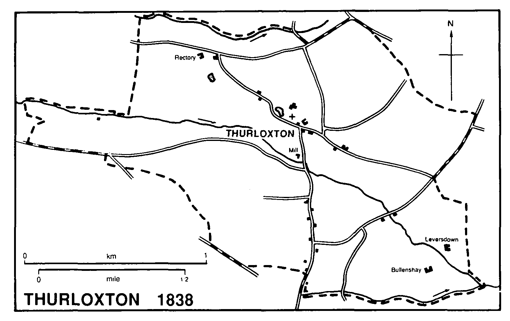
Thurloxton 1838
Thurloxton, probably taking its name from Reyner Thurlac, the 12th-century lord, (fn. 1) lies on the south-eastern slopes of the Quantocks, 6.5 km. north-east of Taunton. It is a small, compact parish 2.5 km. from east to west at its widest point and 1.5 km. from north to south. The parish occupies a shallow combe formed by a stream flowing east and south-east from Clavelshay in North Petherton, between the 137-m. and 46-m. contours. The village of Thurloxton lies in the centre and spreads south towards Adsborough in Creech St. Michael. Parts of the boundary with Creech on the south and with North Petherton on the east and north follow streams. (fn. 2) The ancient parish and the civil parish are coterminous and measure 228 ha. (c. 540 a.). (fn. 3)
Most of the parish lies on Ilfracombe slate with an area of Upper Sandstone in the east. There were quarries in the centre of the village near the church and mill. (fn. 4)
The parish was probably once within the area of the minster church of North Petherton. It may represent the principal part of the estate recorded in 1086 as Tetesberge, (fn. 5) a name apparently surviving as Adsborough in Creech St. Michael, where the rest of the estate may have lain. (fn. 6) Thurloxton formerly had open fields, as indicated by furlong names. (fn. 7) There were 2 a. of woodland in 1086. (fn. 8) Although the parish was said to be well wooded in the late 18th century, (fn. 9) only 22 perches were recorded in 1838. (fn. 10)
Until the mid 19th century Thurloxton village lay scattered, principally along the road running south from the church to Adsborough; the northern part of the road was called Mill Lane, and the southern once formed part of the Bridgwater- Taunton turnpike route. (fn. 11) Several east-west lanes cross the parish. From Howell's Lane in the north, linking Clavelshay with Shearston in North Petherton, another lane runs south-east by the church to the turnpike road, forming from the mid 19th century a second line of settlement, including the Rectory at its western end, Manor House (which is not known to have been a manor house), and the school. The eastern part of the lane was known as Knotcroft Lane. Further south, Boez or Bowes Lane runs west from Mill Lane up the combe towards the Quantock ridge. (fn. 12) The Bridgwater-Taunton road was turnpiked in two stages, the part as far as the Green Dragon inn at the junction with Mill Lane by the Bridgwater trust in 1730, (fn. 13) and the remainder by the Taunton trust in 1751-2. (fn. 14) A tollgate was built between 1838 and 1851, (fn. 15) but both trusts ceased in the 1870s. (fn. 16) Improvements to the line of the road appear to have been suggested in 1822 (fn. 17) but it was not until 1924-8 that, to provide relief work for the unemployed, a shorter route was made cutting across the angle on which the Green Dragon stands. (fn. 18)
Most of the houses in the village are of the later 19th century including Manor House and Thurloxton House, later called Hill View or Hill Cottage. The former mill house dates from the 16th century and the Cottage probably from the 17th. East of the village are the outlying habitations of Leversdown and Bullenshay Farm.
There was a tippler in the parish in 1619 (fn. 19) and three licences were issued in 1674. (fn. 20) The Green Dragon was recorded by name in 1763 (fn. 21) but was almost certainly licensed from 1660. (fn. 22) It closed before 1968 but reopened as a licensed restaurant in 1986. (fn. 23)
There were 25 houses in the parish in 1791 (fn. 24) and 28 in 1801 when the population was 136. Numbers fluctuated during the 19th century: there were 156 inhabitants in 1811, 229 in 1831, 161 in 1881, and 210 in 1891. The total fell to 157 in 1901 and to 124 in 1981. (fn. 25)
Eight men from Thurloxton were fined for involvement in the Cornish rebellion in 1497, (fn. 26) and three men fought for the king in 1647. (fn. 27) The 18th-century diarist James Woodforde lived briefly at Thurloxton. (fn. 28)