A History of the County of Essex: Volume 9, the Borough of Colchester. Originally published by Victoria County History, London, 1994.
This free content was digitised by double rekeying. All rights reserved.
'Medieval Colchester: Growth of the town', in A History of the County of Essex: Volume 9, the Borough of Colchester, (London, 1994) pp. 38-47. British History Online https://www.british-history.ac.uk/vch/essex/vol9/pp38-47 [accessed 25 April 2024]
In this section
GROWTH OF THE TOWN
The Saxon and Norman Town
The Anglo-Saxon town developed in the ruins of the Roman one, but archaeological evidence suggests there was little or no continuity between them. North Hill, Head Street, and High Street follow the lines of Roman streets, but those lines were dictated by North gate, Head gate, and East gate, all of which continued in use. The main Roman gate, the Balkerne gate, was blocked in the late Roman or Anglo-Saxon period to make a stronghold later sometimes called King Coel's castle. (fn. 1) The road from London was diverted southwards to enter the town at the south-west gate, the medieval Head or principal gate. Pottery finds and the sunken huts excavated in Lion Walk and Culver Street suggest scattered early and middle Anglo-Saxon settlement within the Roman town walls, at least in the areas between Head Street, Culver Street, and Lion Walk, and between North Hill and West Stockwell Street. (fn. 2) From the late 10th century the population seems to have increased, and settlement expanded along both sides of High Street, North Hill, and Head Street.
It has been suggested that the intramural area west of the line of Maidenburgh Street and Queen Street, apart from that between High Street and Culver Street, was laid out on a 4-pole unit, probably at the time of Edward the Elder's conquest in 917. (fn. 3) Such a replanning, which occurred in many other towns at that date, is inherently likely, but the suggestion that the area between High Street and Culver Street was laid out later than the rest of the town seems dubious, for Culver Street is the back lane for houses on the south side of High Street, and fits well into an early 10th-century plan. The streets show no other clear sign of late Anglo-Saxon town planning, and Maidenburgh Street, on the eastern edge of the 'planned' area seems to date from the early 14th century. (fn. 4) Any 10th-century town planning presumably involved laying out building plots, including the large urban estates typical of many late Anglo-Saxon towns. The Roman temple precinct, which became the site of the Norman castle, may have been one such urban estate, belonging to the ealdorman or possibly to the king. The site, like much of Colchester, seems to have been uninhabited in the 7th or 8th century when there was a cemetery in its north-west corner, but about the 10th century part of the blind arcade along the southern edge of the temple site was re-used. The first post-Roman buildings on the site, immediately south of the temple podium, probably included a timber hall and seem to have been part of a high status, 10th-century dwelling. (fn. 5) Another estate belonged to the bishop of London. In the early 12th century the south-west corner of the town, bounded by Church Street on the north and Church Walk on the south, Head Street on the east, and the town wall on the west, formed the bishop's soke. It contained the church of St. Mary-at-the-Walls, an otherwise unrecorded chapel of St. Andrew, and the bishop's own house, and presumably also the 14 houses and 4 a. of land which the bishop held in 1086. The bishop also held 2 hides in the fields south-east of the town, extending from the small tributary of the Colne near the later Hull mill as far north as St. Leonard's parish. (fn. 6)
Of the ten medieval churches within or near the town walls, at least six and probably a further three were Anglo-Saxon foundations. St. Peter's at the top of North Hill, whose churchyard seems originally to have extended as far as High Street, was held by two priests in 1066, and may have been the principal church of the early town. Until the 13th century Mile End was within its parish. (fn. 7) The surviving tower of Holy Trinity, south of Culver Street, was added in the late 11th century to an existing nave, (fn. 8) and the tower of St. Martin's also contains pre-Conquest work. Both St. Nicholas's and All Saints' churches seem to follow the late Anglo-Saxon alignment of High Street and hence to have been built before the street was diverted southwards round the Norman bailey wall c. 1100, (fn. 9) and its dedication to an obscure Mercian saint suggests that St. Runwald's, in the market place in High Street, was founded before or soon after the Conquest. St. Mary's-at-the-Walls, in existence by the earlier 12th century, (fn. 10) was presumably built as a private church of the bishop of London; early, possibly 9th-century, graves have been found south of its churchyard, and its parish like St. Peter's extended well beyond the walls. (fn. 11) St. Botolph's, just outside the south gate of the town, was a parish church in the later 11th century, and another probably late Anglo-Saxon church, identified with the St. John the Evangelist's church said to have been on or near the site of St. John's abbey, stood a little further south, just east of the medieval St. Giles's church. (fn. 12) Both St. Botolph's and the putative St. John's lie in or near Roman cemeteries, but there is no evidence that either originated as a sepulchral chapel. At the end of the 11th century St. Botolph's was the home of a community of secular canons, who adopted the Augustinian rule c. 1100, but that community was probably of recent origin, not the survivor of an earlier minster church. Its parish, which presumably originally included land both inside and outside the walls, was probably enlarged after 1100 by grants of tithe to the Augustinian priory. (fn. 13) The only large estate south-east of the town which did not belong to the priory or to St. John's abbey, Battleswick manor, was in St. Giles's parish, and that suggests that the precursor of St. Giles's, not St. Botolph's, was the original parish church of Donyland in the south-east of the liberty. (fn. 14)
In 1086 a total of 354 houses paid customary dues and a further 51 which had paid in 1066 no longer did so. (fn. 15) Those, with the 14 houses on the bishop of London's soke, make a total of 419, and there may have been other houses which had never paid dues. Although there was considerable open space within the walls throughout the Middle Ages, settlement extended outside the them by 1086. Besides their houses, individual burgesses and other landowners held a total of c. 1,304 a. of land, most of it in parcels of between 1 a. and 10 a. It probably lay mainly in the fields north, south-west, and south-east of the town; Bury St. Edmunds abbey's 30 a. may already have included the 'wic' which it held in Mile End in the 13th century. (fn. 16) The burgesses as a body also held 51 a. of meadow, perhaps along the Colne at the Hythe, 8 perches of land around the walls, and 80 a. in their common, probably waste land within the walls and along some of the roads leading out of the town. The borough owned land in all those places in the 14th century. (fn. 17) The rural settlements in Greenstead, Lexden, and West Donyland, and possibly Mile End were distinct from the town in 1086. Indeed, part of what was later West Donyland seems to have been in Lexden hundred, and the status of Lexden itself was disputed. (fn. 18)
The late 11th century and the 12th were marked in Colchester as in many other towns by a spate of building work. The construction of the first phase of the castle c. 1076 changed the physical appearance of the town, but may not have altered its layout if the site was earlier a royal residence. High Street was diverted southwards by the building of the south wall of the bailey c. 1100. The foundation of St. John's abbey in 1095 on a small hill south of the town, and of St. Botolph's priory in the existing parish church just outside the south gate c. 1100 transformed the south-east corner of the town. (fn. 19) During the 12th century both houses erected impressive churches and conventual buildings, and their presence almost certainly attracted lay settlement. St. James's church, at the east end of High Street, was built in the 12th century or earlier, and St. John's abbey built St. Giles's church in its graveyard in the early 12th century. The leper hospital of St. Mary Magdalen was founded early in the 12th century ½ mile south-east of the town. (fn. 20) Much building was done with re-used Roman stone and tile, and the quarrying of surviving Roman buildings for materials probably cleared areas within the walls, particularly perhaps Maidenburgh and Eldland north of Eld Lane, for medieval development. (fn. 21)
The Early Middle Ages
Throughout the Middle Ages the principal houses and most of the shops stood in or near the market, which was held in High Street between its junction with North Hill and the castle gate near the corner of Maidenburgh Street. There is little evidence for the concentration of the shops of different trades in specific areas, but there were cobblers' shops at the south end of East Stockwell Street in the 13th century. (fn. 22) There may have been more specialization by the 1380s when Cook Row near the moot hall, 'la Bacherie', and Cordwainers' Row, were recorded. (fn. 23) The butchers' shambles were in the middle of the market, near the moot hall, possibly round St. Runwald's church, and the fish market was nearby, west of the church. The corn market was at the west end of High Street. (fn. 24) The fullers, dyers, and tanners, who needed water, worked along the Colne between North bridge and Middle mill, and at East bridge. Fullers held land under the wall between Ryegate and North gate in the 1220s; c. 1242 a tanner, a tenterer, and a fuller had houses outside North gate, and in 1328 Edmund le Chaloner sold his tenement beyond North bridge to a fuller. (fn. 25) John Dyer, a clothmaker if not actually a dyer, owned at least two houses in East Street and a tenter at East mill at his death in 1330. (fn. 26)
Of the six known 12th-century stone houses, three, including the moot hall, were on the north side of High Street, one on the south side of the street at the corner of Pelham's Lane, one on the corner of Culver Street and Lion Walk, and one in East Stockwell Street. Most seem to have had solars above undercrofts, and the moot hall had a solar block at its east end by the mid 13th century. They were set well back from the street frontage which may already have been occupied by smaller houses and shops. (fn. 27) The Pelham's Lane house belonged to Joan daughter of Richard Marcian, one of the leading men in early 13th-century Colchester; in 1306 its plot extended from High Street to Culver Street. (fn. 28) Conveyances of part of a messuage in the market in the 1240s and disputes over half a messuage in 1248 and 1285 (fn. 29) suggest the division of properties in the more sought-after parts of the town. St. Runwald's church was probably an early encroachment on the market place, and by the later 13th century there were shops around it. (fn. 30) The bailiffs leased a plot 9 ft. by 6 ft. on the south side of the church, presumably for building, in 1331-2. (fn. 31)
In 1258 a house in East or West Stockwell Street had upper and lower rooms, and the occupier was expected to enlarge it. (fn. 32) A lease, probably made in 1263-4, of a tenement in the market excluded the room under the solar called 'Tholuhus', (fn. 33) perhaps either a room for the collection of market tolls or 'the oil house'. By 1290 there were houses in the market with cellars below and solars above the shops or selds built in front of them. (fn. 34) Most houses were probably of timber and plaster, like the one near East gate, half of which was granted to a widow in 1321. (fn. 35)
The Friars Minor acquired a large site in the north-east quarter of the town, between High Street and the wall, before 1237. The land, like that which Henry III gave them in 1237, may have been part of the castle estate. St. Cross hospital, in a detached part of Stanway parish outside Head gate, was founded before 1272, and both St. Anne's chapel and hospital on the Harwich road and St. Catherine's hospital in Crouch Street were founded by the mid 14th century. Comparatively little work was done on the parish churches, but St. Giles's was rebuilt or remodelled, presumably by St. John's abbey, in the 13th century, and the lower stages of the tower of St. James's may have been built in the early 13th century. (fn. 36)
A house beyond East bridge, held of St. John's abbey with cultivable land and meadow in the late 12th century, may have been on the abbey's manor of Greenstead; other houses beyond the bridge in the mid 13th century seem to have been part of the town, (fn. 37) although apparently separated from it by East Hill which was sparsely populated. The settlement at East bridge may have been associated with quays, like that recorded in 1439. Permission to build a footbridge at the Hythe in 1407 was conditional on boats being able to reach East bridge, and a similar provision was made when the footbridge was replaced by a cart bridge in 1473. (fn. 38) Three houses outside the walls in Head ward, presumably in Headgate or Crouch Street, were recorded about the 1220s. There were houses outside North gate c. 1242, and beyond North bridge by the 1270s. (fn. 39) The two 11th-century churches outside South gate, St. Botolph's and St. John the Evangelist, imply early settlement there, but there is no documentary evidence for it until the 13th century when there were houses in Lodders Lane (later Abbeygate Street) and Berisland (later Vineyard Street). In 1297 St. John's abbey owned land and buildings in Stanwell Street on St. John's green, and by that date there were houses outside Schere gate. (fn. 40) There was at least one house in Moor Street (later Priory Street) in 1296. Magdalen Street seems to have developed as an agricultural suburb by 1300. (fn. 41)
Behind the main streets there was still empty space, like the curtilage in Culver Street recorded c. 1270. (fn. 42) A house in Wyre Street was leased in 1271 with two selions of land 17 ft. wide, a term which suggests it was or had recently been arable, (fn. 43) and Queen Street, which runs diagonally from just south of High Street to South gate, may have originated as a path across agricultural land. The borough leased an empty plot in Wyre Street 50 ft. by 20 ft. in 1335-6; a plot of town land at the end of the street, in Eldland, seems to have been empty in 1360, but another plot there had houses on it in 1340-1. (fn. 44)
The borough repaired the town walls c. 1312, but no other major public building work can be securely ascribed to the earlier 14th century. Maidenburgh Street was developed in the 1330s, plots 18 ft. wide being leased by the borough. At least one lease required the tenant to build a house on the plot, and an adjoining plot had been built up by 1342-3. (fn. 45) The northern ends of East and West Stockwell Streets may have been developed about the same time; part of a 14th-century hall survives at no. 30 East Stockwell Street. (fn. 46) There was still pasture land or 'moor' in Maidenburgh in 1354-5, possibly near a watercourse which flowed from St. Helen's well near St. Helen's chapel to the castle ditch. (fn. 47)
The Later Middle Ages
As the population increased in the later 14th century, so did the development of areas behind the main streets, notably Maidenburgh, and of land outside the walls. The bailiffs leased a partly built-up plot c. 6 yd. by c. 8½ yd. near St. Helen's well in 1377-8, and in 1381-2 they leased empty plots c. 14 yd. long by the castle ditch and St. Helen's chapel. Further empty plots in Maidenburgh were recorded in 1387-8 and 1390-1. (fn. 48) The bailiffs leased land between the north wall and the river to extend a tannery in 1368-9, and in East Hill in the 1360s and 1370s. A newly built-up plot on the west side of North gate was recorded in 1387. (fn. 49) By 1357 there were shops in High Street as far east as the castle ditch. (fn. 50) About the 1370s William Reyne acquired or built 'new rents', the later Red Row, on High Street in front of St. Peter's churchyard. A newly built house in Eldland was recorded in 1396-7. (fn. 51)
Pressure was increasing on street frontages even away from the market; a tenement on the north side of High Street in All Saints' parish was divided into three or more parts in 1366. In 1366-7 a house between North gate and North bridge was only c. 18 ft. wide. A house outside North gate had been divided by c. 1380 when Colne priory received a rent from the part between its great gate and the town wall. (fn. 52) A house in the corner of Sholand, perhaps at the top of Maldon Road, was recorded in 1349-50, and there were houses in Childwell Lane by 1384. (fn. 53) Cloth-workers were established along the brook which ran eastwards from Stanwell across St. John's green into St. Botolph's priory precinct: a John le Dyer had a tenter at Stanwell in 1361, and a Sudbury draper acquired a tenement with a broad lead gutter there from John Pod, dyer, before 1383. (fn. 54)
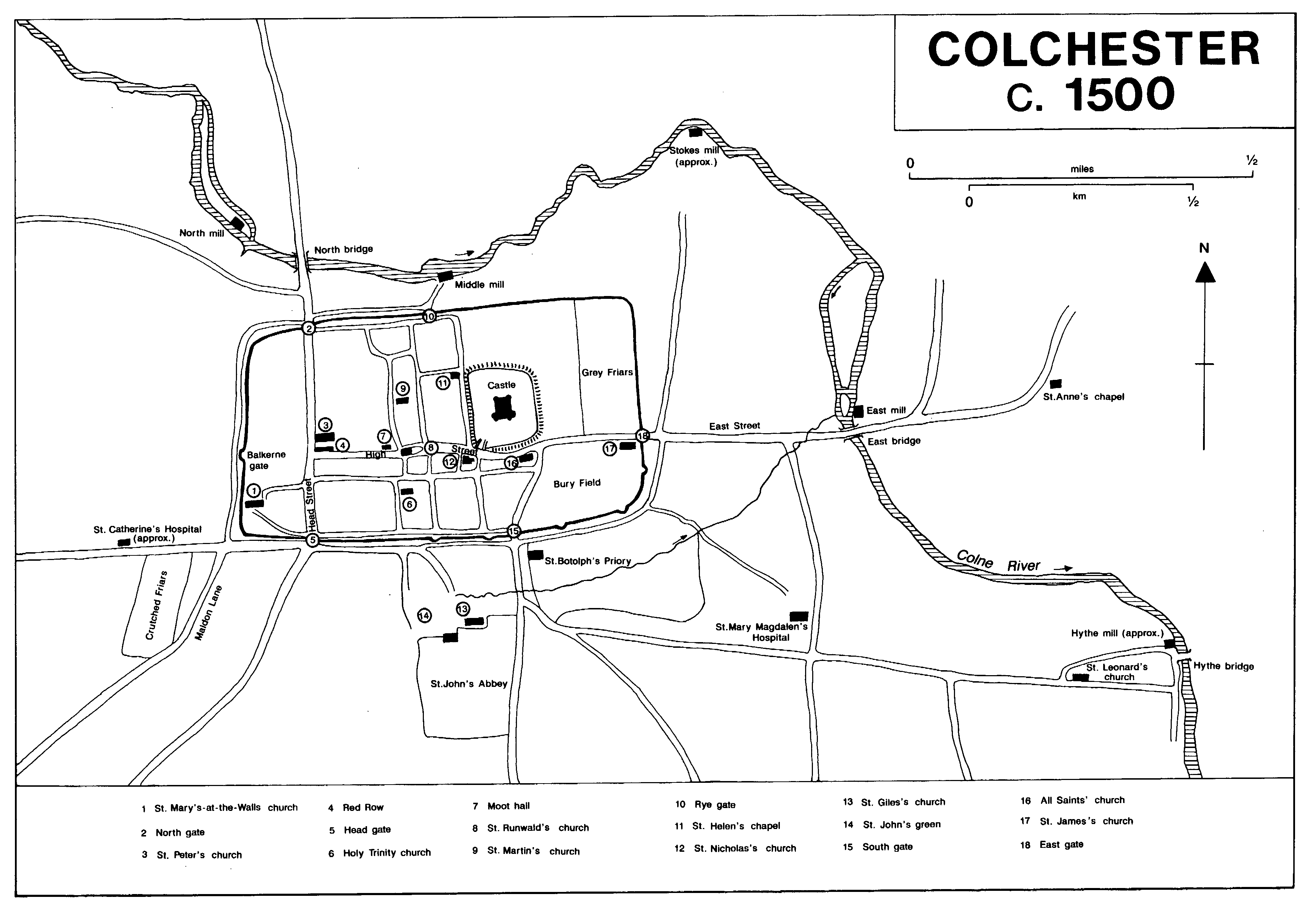
COLCHESTER c. 1500
By the early 15th century building along High Street was probably continuous as far as East gate. In 1428 the owner of a house adjoining the Greyfriars was forbidden to place his timbers on the friars' wall. Although in 1402 there were only eight tenements in High Street between Queen Street and St. James's church, each may have contained several houses; in 1480 three tenements in the market, in St. Nicholas's parish, contained a total of 12 separate houses. (fn. 55) In 1420 a plot with a stall on it on the north side of High Street near the castle was only 9 ft. long by 5 ft. wide. The shops in the middle of High Street round St. Runwald's remained, and by the late 14th century there were at least five under the church wall. Middle Row, east of church and shops, had been built by 1488 when a 31 ft. long gutter from one house discharged at the corner of the church. (fn. 56) In 1481 and 1482 John Howard, Lord Howard, built new houses in Colchester, one of which, on the south side of High Street, became the New inn, later the Red Lion. (fn. 57) The building was put up in several stages, the earliest being the late 15th-century western block to which a hall and east range were added early in the 16th century. The hall was set back from the street behind a small court. The frontage, which was elaborately decorated and jettied, incorporated a row of shops. Apart from the Saracen's Head, on the main London road opposite the Crutched Friars, all the nine known medieval inns or taverns were in High Street, all but one of them in the market. There is no evidence that any were purpose-built, and they were probably in large houses. (fn. 58)
Away from the main streets, a plot of land near St. Helen's chapel was built on shortly before 1411. Four newly built rents in St. Helen's Street (probably Maidenburgh Street) were recorded in 1416. In 1430 the bailiffs leased an empty plot in All Saints' parish c. 21 yd. square on condition that the tenant built houses on it within three years. St. John's abbey had two new shops in Wyre Street in 1478. (fn. 59)
In East Street, outside the walls, a new house was built on to an existing house in the early 15th century, a new rented building was recorded in 1416, a new cottage in 1422, and buildings on a once empty plot in 1485. (fn. 60) Part of a divided tenement there was conveyed in 1420, and there was a dispute about an eavesdrop between a cottage and two houses on the north side of the road in the same year. There were disputes about similar eavesdrops outside South gate in 1405 and beyond East bridge in 1419. (fn. 61) In 1414-15 a house outside South gate seems to have had a street frontage of only 12 ft. (fn. 62) In 1435 the town court heard a dispute over a contract for rebuilding a hall and two solars in North Street. The bailiffs demised a newly built house on a plot 93 ft. long and 16 ft. wide outside North gate, probably between the wall and Balkerne Lane, in 1430. (fn. 63) Other land between the north wall and Balkerne Lane was newly built on in 1470. There were houses between St. Mary Magdalen's hospital and the Hythe by 1408. (fn. 64)
Apart from the repair of the town wall, which included the addition of bastions on the south-east, between 1381 and c. 1413, there was little public building in the later 14th century. In the following century, however, there was considerable church building, at St. Martin's, St. Peter's, and St. Leonard's early in the century, All Saints' in the middle, and Holy Trinity, St. Leonard's, and St. James's later. (fn. 65)
Most of the late medieval houses whose plans are known from excavation or from surviving buildings comprised a hall and one or two cross wings, the hall usually long side on to the street. Other wings might be added at the back. All but the two major inns, the Red Lion and the George, are of two storeys, and all are timber-framed. (fn. 66) A number of shop fronts, which are characterized by one or two wide and formerly open windows, survive. Along High Street and other main streets there were probably many small shops in front of the domestic buildings, as at the George and no. 136 High Street, and at the Rose and Crown at the east end of East Street. Shops also occurred in buildings which look like cross wings but which may have been self-contained units with living quarters at the back and on the upper floor. No. 73 High Street and no. 3 West Stockwell Street may have been of that type although they could have been commercial adjuncts to adjacent houses. A shop in the front room of a service wing, which also incorporates a cross passage, is the probable explanation of the plans of no. 93 Hythe Hill and no. 7 Queen Street. All of the halls that survive or are known from excavation are aligned on the street. Those in Middleborough and Stockwell Street, as well as those presumed to have existed at the Minories in High Street, were on the street frontage. At the George in High Street, as at the moot hall, shops separated the hall from the street, and at the Rose and Crown there was a small courtyard between them. A similar arrangement may have existed at Tymperleys in Trinity Street where the central range has been rebuilt but appears to have been set back far enough for a street range and a courtyard. The number and arrangement of other rooms in the street range was largely determined by the width of the plot. In the 14th century two houses in Middleborough had only the hall and service rooms on a plot of c. 40 ft., a common width, and the later cross wings were developed partly at the expense of the hall. (fn. 67) At 30 East Stockwell Street the cross passage is the only part of the hall range to have survived in what appears to have been a structurally integrated hall and cross wing. By the later 15th century wings were often built down one or both sides of the plot behind the hall. Tymperleys, the west wing of the Rose and Crown, and nos. 13-15 North Hill are examples of rear wings with high-quality carpentry which were probably parlour wings.
Two or more houses under one roof, like the two houses under one roof surrendered to the bailiffs in 1341-2, may have been divided buildings, or terraced housing like the three rents under one roof in East Street conveyed in 1433 with a latrine, a small chamber called a counting house, and an outhouse called a lodge. Similar speculative housing is known from other towns. (fn. 68) Two shops surrounded by one large house on three sides in 1412 (fn. 69) had apparently been built to face the street in front of a hall, between its two projecting wings. Other late medieval houses were also complex structures. In 1447 one called the warehouse, apparently in St. Botolph's parish, had 'houses' or rooms and a hall above it. A house in High Street in 1453 had a parlour with a chimney as much as 43 ft. behind the street frontage. In 1404 a hall and a kitchen with a solar above it were devised apart from the rest of the house, with access to them through the cart gate. (fn. 70) In the market place a house called the Hart, possibly an inn, had at least four chambers in 1462. In the late 15th century a widow sold the greater part of her house to her son but reserved for her own use the lower parlour, three 'houses', and the chamber over the great parlour. (fn. 71)
Gates called 'burgates', which may originally have led into small urban estates, (fn. 72) were a feature of some Colchester houses. They were recorded in Head Street in 1346 and 1382, on the south side of High Street in 1363, on the north side of High Street in All Saints' parish in 1366, in or near Eldland (at the bottom of Wyre Street) in 1396-7, in Queen Street in 1402, and on the south side of High Street in All Saints' parish in 1467. (fn. 73) One, at the end of Moor Street in 1425, (fn. 74) was outside the wall. The Head Street burgate led into a courtyard containing a barn for storing corn, a beer house and presumably other outbuildings. Other houses had large porches, encroaching on the street, like the great timber penthouse complained of in 1422-3. One porch, at the entrance to West Stockwell Street was c. 7½ by c. 2 fit. in 1401-2. (fn. 75) 'Poys', which seem to have been lean-to constructions with solid walls at their short ends, were also added to many houses. Plots leased for the walls of a poy in 1364-5 were 9ft. by 3½ ft., and for another, outside Head gate in 1391, 8 ft. by 2 ft. (fn. 76)
Despite the increased building, there was open land within the town wall. Castle field still lay between the castle and Greyfriars in 1478, when it was being encroached on for gardens. (fn. 77) In the south-east corner of the town the Bury field survived throughout the Middle Ages, although in 1353 a man was presented for inclosing part of it. (fn. 78)
Bequests for tithes in 14th- and 15th-century wills suggest the relative wealth of different parts of the town. The richest townspeople seem to have lived in the part of High Street in St. Runwald's and St. Nicholas's parishes, and in East and West Stockwell Streets, which extended into St. Martin's parish. The west end of High Street and perhaps North Hill, in St. Peter's parish, was probably also a wealthy area: while the evidence of wills is not strong, five bailiffs are known to have lived there. Although few of the richest men lived in St. James's, the parish produced the highest number of surviving wills, suggesting a large population of middling merchants and tradesmen; the parishioners were able to rebuild the church on a grand scale in the later 15th century. The southern part of the town was a poor area: the wills of Holy Trinity parishioners were comparatively few and poor and St. Mary-at-the-Walls seems to have been poorer than any parish except the small, rural, St. Mary Magdalen. St. Leonard's at the Hythe, on the other hand, was richer than many of the intramural parishes. (fn. 79) The subsidy assessment of 1487 on the whole confirms the evidence of wills; parts of Holy Trinity, however, where average payment was the highest in the borough but few parishioners were liable for subsidy, may have been becoming more prosperous, while St. Martin's where average payment was the second lowest, was becoming poorer. (fn. 80)
The Hythe
The settlement at the Hythe or New Hythe, Colchester's port, was physically distinct from the town, being separated from it by arable fields, although it was legally and constitutionally part of the town. It presumably began about the 11th century when the port moved north from the old hythe or Old Heath. (fn. 81) The move at Colchester, as at other ports, was probably associated with the construction of quays and possibly with the first improvements to the river. A cut across the marshes in Wivenhoe parish opposite Old Heath was made after the parish boundary had been fixed but probably before the surviving borough records begin in the early 14th century. St. Leonard's church at the Hythe was founded before the mid 12th century, but its compact parish contrasts with the dispersed parishes of the intramural churches and suggests that it was relatively late. (fn. 82) In the late 12th century and the early 13th the settlement was called Heia as well as Hythe, the former name presumably referring to inclosures, perhaps of meadow, made when the port was laid out. A tenement there was given to St. John's in 1160, and a rent from a house there in the later 12th century. (fn. 83) St. Leonard's church stands half way up Hythe Hill, well back from the water front and probably on the edge of the 12th-century settlement; there was still arable land near it in the mid 13th century. (fn. 84)
The Hythe was developed, both as a port and as a suburb, in the 14th century, the borough leasing land for quays and warehouses in the 1330s and 1340s. (fn. 85) By the mid 14th century the quays and the road behind them may have extended some distance southwards from the bottom of Hythe Hill. Buildings were similar to those in the rest of the town, and there are indications of pressure on street frontages. A shop with a solar above it had apparently been built on a tenement at the Hythe by 1384. A new building encroached on the road in 1392-3. (fn. 86) Most if not all houses stood along Hythe Hill or behind the quays, but by 1352 there was a back lane, North Lane or Church Lane, behind houses on the north side of Hythe Hill. South Lane, recorded in 1427, may have been the road behind the quays. (fn. 87) A footbridge built across the river in 1407 was replaced by a cart bridge in 1473-4, (fn. 88) but there was no building on the eastern bank of the river in the Middle Ages.