A History of the County of Middlesex: Volume 7, Acton, Chiswick, Ealing and Brentford, West Twyford, Willesden. Originally published by Victoria County History, London, 1982.
This free content was digitised by double rekeying. All rights reserved.
Diane K Bolton, Patricia E C Croot, M A Hicks, 'Acton: Communications', in A History of the County of Middlesex: Volume 7, Acton, Chiswick, Ealing and Brentford, West Twyford, Willesden, ed. T F T Baker, C R Elrington (London, 1982), British History Online https://www.british-history.ac.uk/vch/middx/vol7/pp2-7 [accessed 9 May 2025].
Diane K Bolton, Patricia E C Croot, M A Hicks, 'Acton: Communications', in A History of the County of Middlesex: Volume 7, Acton, Chiswick, Ealing and Brentford, West Twyford, Willesden. Edited by T F T Baker, C R Elrington (London, 1982), British History Online, accessed May 9, 2025, https://www.british-history.ac.uk/vch/middx/vol7/pp2-7.
Diane K Bolton, Patricia E C Croot, M A Hicks. "Acton: Communications". A History of the County of Middlesex: Volume 7, Acton, Chiswick, Ealing and Brentford, West Twyford, Willesden. Ed. T F T Baker, C R Elrington (London, 1982), British History Online. Web. 9 May 2025. https://www.british-history.ac.uk/vch/middx/vol7/pp2-7.
COMMUNICATIONS.
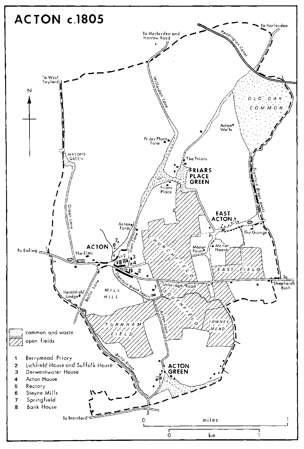
Acton town lay on the high road from London to Oxford, which was not superseded until Western Avenue was built in the 1920s. Pavage was granted in 1358 and 1363 to men from Acton and Uxbridge to repair the highway in their parishes and as far as the City of London, (fn. 1) and a Londoner left money towards its repair in 1504. (fn. 2) Acton inhabitants often failed to repair the road in the 17th and 18th centuries, when landholders were ordered to cut back hedges to prevent robberies. (fn. 3) In 1737 it was proposed to use the spring east of Acton town to keep the road clear. (fn. 4) The worst stretch was Acton hill, which rose steeply from the water splash west of the church and towards which money was left for repairs in 1438. (fn. 5) The water splash was c. 4 m. lower than the modern road and waggoners were warned at the top of the hill, which as late as 1899 was a major obstacle: the R.S.P.C.A. and others provided a trace horse to help loads free of charge, and 22 horses laboured for 4 hours to haul a giant boiler over the hill. (fn. 6) The highway was turnpiked by the Uxbridge turnpike trust in the early 18th century, (fn. 7) with a tollgate at the 4-mile post, where Bromyard Avenue later joined Uxbridge Road by the former King's Arms.
A highway leading south from the top of Acton hill to Gunnersbury and Brentford was known as Bollo Bridge Lane in 1746, (fn. 8) Brentford Lane in 1769 (fn. 9) and 1866, (fn. 10) and also as Gunnersbury Lane in the 1860s. The last name, once applied to a more westerly road in Ealing along the line of the modern Gunnersbury Avenue, was usual by 1889. (fn. 11) It was also occasionally known as Bollo Lane, (fn. 12) although that name normally referred to the way from Bollo bridge, where Gunnersbury Lane crossed the boundary, which followed Bollo brook to Acton common and existed by 1394. (fn. 13) The main route northward from Acton town, starting by the church, was called Horn Lane by 1746 (fn. 14) and may have been the high road towards Harrow called Stone Lane in 1377. (fn. 15) It ran past Friars Place Farm before branching slightly north-westward along the modern Park Royal Road, known as Willesden Lane in 1842, to join Norwood or Green Lane at the boundary and lead thence to the Harrow road.
Minor roads included one which branched off Horn Lane to Friars Place and thence northeastward to Harlesden green, skirting the west side of Old Oak common. Known as Holsden Green Lane in 1746 and Wales Farm Road in 1891, it probably became busier in the 18th century as the chief approach to Acton wells, then a fashionable resort. The parish was indicted in 1776 for the upkeep of the stretch from Harlesden green to Old Oak common, (fn. 16) but no path over the common was marked in 1842. Another lane led southward from Friars Place to the west end of East Acton and was called Worton Green Lane in 1639 (fn. 17) and Batteridges Lane, after a local inhabitant, in 1746. East Acton was connected with Uxbridge Road by a lane from the west end of the green. The lane also ran across the green to the Hammersmith boundary and thence northward to Old Oak common as Old Oak Lane in 1720 (fn. 18) and Old Oak Common Lane in 1866. Also from East Acton a footpath led to the parish church along the modern Churchfield Road, being joined by another from the end of the green in the middle of Church field. As it left Church field the path formed a lane, apparently called Lyvyngeslane in 1380, (fn. 19) and continued across Horn Lane past the north side of the church. Acton Green was connected to the town by a cartway along the western edge of South field to Uxbridge Road and by a path which ran from the common to High Street just south of the church and partly survived in 1980. Farther west a lane ran north from Acton ponds to Masons green and thence as a path to West Twyford, marking part of the boundary. The portion as far as Masons green was called Mill Lane in 1746 and Green Lane in 1866. It was moved slightly westward by Samuel Wegg in 1758 (fn. 20) and was also known as Wegg Avenue and then as Twyford Avenue.
The principal roads survived the spread of suburban housing and the fencing of most of the paths across Old Oak common by 1891. The vestry and its successors strove throughout the 19th century to keep open the path from Masons green to West Twyford. James Richard Wood tried to block it in 1813, together with the way south of Friars Place farm from Horn Lane past the moated site to Masons green, which probably had been important in the 15th century and earlier. (fn. 21) Harlesden Green Lane was also blocked by landowners, and committees were set up in 1868 and 1888 to protect rights of way. (fn. 22) A new road continued Old Oak Common Lane southward to Uxbridge Road by 1891. The road pattern was disrupted only in the late 1920s, when the arterial road called Western Avenue cut across the parish from just north of East Acton green to the north-west corner, near Twyford.
Two bridges carried Uxbridge Road in 1826. (fn. 23) Fordhook bridge at the western boundary, where Bollo brook passed under the road, was built by the Uxbridge turnpike trustees in 1776. A bridge at Acton Bottom, west of the church where Stamford brook met the high road, existed in 1742 and was rebuilt by the trustees in 1769. It may have been one of the four bridges between Notting Hill and Acton that the bishop of London or his tenant at Wormholt farm, Hammersmith, was liable to maintain, (fn. 24) but more probably they were responsible for a bridge at the east end of the parish, where Stamford brook's eastern branch crossed the road, which apparently was known as Mile End bridge in 1651. (fn. 25) In 1420 John Fyghter of Acton left money towards the new bridge between London and Acton, which may have been in the parish. (fn. 26)
The bishop in 1663 also repaired Bollo bridge, (fn. 27) in existence by 1239, (fn. 28) where the road from Acton hill to Gunnersbury crossed Bollo brook. It was decayed in 1554, when the bishop, as lord, was liable for its upkeep. (fn. 29) There were bridges on the road later called Acton Lane where it crossed Stamford brook east of Berrymead and at the north-west corner of Acton common where a stream called Mill Hill brook met the lane.
ACTON c.1805
In the extreme north part of the parish the Paddington branch of the Grand Junction canal from Bull's Bridge junction, near Southall, to Paddington, was opened in 1801. (fn. 30) A bridge carrying Harlesden Green Lane across the canal was maintained by the Grand Junction Canal Co., (fn. 31) but the canal itself made little local impact, since the area did not become industrial until the coming of the railways.
In 1764 the Acton Machine ran on Saturdays from the George at Acton to Oxford Street, returning two hours later, with a similar journey from London to Acton, returning an hour later, and every Saturday a coach went to Acton at 9 a.m. (fn. 32) In 1825 a short-stage coach from Acton to the City made four return journeys a day, (fn. 33) and in 1845 the London to Oxford coaches still passed, supplemented by an omnibus four times a day and by daily carriers. (fn. 34) In 1856 the London General Omnibus Co. took over the Bayswater horse bus fleet, which plied between the Victoria in Acton Bottom and London Bridge. (fn. 35)
Acton's first tram service, between the Princess Victoria in Askew Crescent, Acton Vale, and Uxbridge Road (Shepherd's Bush) station, was opened by the Southall, Ealing & Shepherd's Bush Tram-Railway Co. in 1874. (fn. 36) It soon closed but reopened and was said to carry 1,000 passengers daily, an extension to Acton Lane being opened in 1878. The line was taken over in 1881 by the West Metropolitan Tramways Co. but was in a bad state when sold in 1894. It was bought by the new London United Tramways Co., which extended it westward to the White Hart, Acton hill, in 1895 and replaced the Shepherd's Bush depot by one on the south side of Uxbridge Road west of the Red Lion, with 7 tracks and housing 50 cars. The line between Acton and Shepherd's Bush was doubled throughout and workmen's cars ran every morning from Acton to catch the early trains at Uxbridge Road station, with through tickets for tram and train. Birch Grove, near the Ealing boundary, was the limit for a 1d. journey from London. (fn. 37) An all-night service of horse cars ran by 1899.
London's first electric street tramway was started by the L.U.T. in 1901 between Acton and Shepherd's Bush, with extensions later in that year through Ealing to Southall. (fn. 38) A service from Hammersmith to Southall and Uxbridge by way of Acton started in 1904. A proposed line to Harlesden along Horn Lane and Old Oak Lane was dropped because of the county council's plans, although the route was opened finally, by the Metropolitan Electric Tramways Co., in 1909. A service from Acton to Putney (Surr.) began in 1928, run jointly by the L.U.T. and the L.C.C. In 1933 the tramways passed to the London Passenger Transport Board and in 1936 the Hammersmith and Acton section was converted for trolleybuses. (fn. 39)
Electric trams prompted the L.G.O.C. to improve its horse buses, provide a new service from Acton to Charing Cross, and cut fares, (fn. 40) but horses soon gave way to motor buses. By 1910 a motor bus ran daily from Ealing and Acton along Uxbridge Road through the City to East Ham (Essex), and by 1914 new services connected Acton with central London and Barking (Essex). By 1932 motor buses along Western Avenue connected East Acton with Putney bridge, (fn. 41) and in the 1920s independent companies ran a successful service from Finchley to Wandsworth (Surr.) through Willesden and Acton. (fn. 42)
Although its main line ran through the parish as early as 1838, the G.W.R. did not open Acton, later Acton main line, station until 1868. (fn. 43) Interested at first chiefly in long-distance traffic, the G.W.R. made little effort to develop suburban passenger services and neither did the two other main-line companies whose lines ran through Acton: the London & North Western in the extreme northern tip and the London & South Western in the extreme south. (fn. 44) Local passenger transport was left mostly to subsidiary companies and in 1891 the local board still pressed for fuller and cheaper train services. (fn. 45)
Acton's first station was opened in 1853 as Acton, renamed Acton Central in 1925. It was on the North & South Western Junction's line which ran southward through the middle of the parish, linking the L.N.W.R. line near Kensal Green with Old Kew junction on the L.S.W.R.'s Windsor loop. (fn. 46) The L.S.W.R. worked the first freight traffic, while passengers were left to the North London Railway, a subsidiary of the L.N.W.R. Passenger traffic was light at first but in 1858 trains were extended to Richmond (Surr.) and Twickenham and in 1863 to Kingston-upon-Thames (Surr.). When in 1865 the N.L.R. and L.N.W.R. jointly opened a station at Broad Street, Acton had a direct rail link with the City, which could be reached by a few fast trains in 30 minutes. From 1869 a line from South Acton junction to Richmond provided a more direct route, and trains ran alternately to Richmond and Kew Bridge. (fn. 47) South Acton station, just north of South Acton junction, was opened in 1880; from 1909 almost all trains from Broad Street ran straight to Richmond, while Kew Bridge was served by a branch from Acton.
Later railways developed separately either in the north or in the south part of the parish. In the north the Midland & South Western Junction opened the Dudding Hill loop between the Midland's line at the Welsh Harp and the N.S.W.J.'s at Acton Wells junction, south of Willesden junction, in 1868. (fn. 48) Intermittent passenger services started in 1875 from Cricklewood to Acton, with trains at first running through to Richmond, later to Earl's Court on the District line, and finally from 1894 between Child's Hill and Gunnersbury only. Although the passenger service ceased in 1902, the line continued to be worked for freight by both the Midland and the L.S.W.R. and their successors. The Midland ran goods trains from Acton to its Kensington depot until 1878. (fn. 49)
The G.W.R. opened a spur in 1877 connecting its main line with the N.S.W.J. at Acton Wells junction, which was used chiefly for goods but also carried passengers from Southall to Willesden from 1888 until 1912. (fn. 50) In 1904 the company began another suburban service between Westbourne Park and Greenford on the first section of its new Birmingham line, using steam-powered motor cars. (fn. 51) The one regular station, at Park Royal, was first used in 1903 for the Royal Agricultural Society's show, but continentalstyle halts were provided at North Acton, opened in 1904, and Old Oak Lane, opened in 1906. (fn. 52) Services lasted until 1947 but remained infrequent, despite the speed of nearby building.
The Ealing and Shepherd's Bush railway was authorized in 1905, to link the G.W.R. with the Central London line, the first used by the G.W.R. for freight traffic to the West London line in 1917. Passenger services began only in 1920 when the Central London, which linked with the new line at Wood Lane (White City) station, began to run electric trains from the City and west end of London to Ealing Broadway, using electricity from the G.W.R.'s power station at Park Royal. (fn. 53) At first the only station within reach of Acton was East Acton, beyond the boundary in Hammersmith, opened in 1920 to serve the L.C.C.'s Old Oak housing estate. In 1923 West Acton and North Acton stations were added: the second, not far from the halt of 1904, allowed interchange between the Central London and the G.W.R.'s steam service. The G.W.R. itself provided workmen's trains between Greenford and Kensington over the line from 1922 to 1938, extending them to Clapham junction from 1933. (fn. 54) Under the New Works Programme of 1935 the G.W.R. was to build extra tracks along its Birmingham line from North Acton to Ruislip, for the Central line to carry suburban traffic, (fn. 55) a project finally carried out in the late 1940s in collaboration with the L.P.T.B. Thereafter the G.W.R. closed its platforms at North Acton and confined its suburban activities to freight, running its steam trains on separate tracks.
In the south part of the parish the Hammersmith branch line ran from the N.S.W.J.'s line at a point slightly north of Acton Lane, called Acton Gatehouse junction. (fn. 56) From 1858 it carried passengers to its Hammersmith terminus north of Chiswick High Road, renamed Hammersmith and Chiswick in 1880. A rail motor car worked the line from 1909, when halts were built at Rugby Road, Woodstock Road, and Bath Road in an effort to revive traffic. Closed to passengers in 1916, the line continued to carry goods, mainly coal, until 1965. (fn. 57)
Passenger services to the City from the south part of the parish began with the opening in 1877 of the Hammersmith Junction line, a joint enterprise whereby the Metropolitan District Railway ran trains from the City to Richmond over the L.S.W.R.'s tracks and used its station at Turnham Green. (fn. 58) That station alone served the extreme south part of Acton until 1879, when the District built a line from Turnham Green to Ealing Broadway, with stations at Acton Green, renamed Chiswick Park and Acton Green in 1887 and Chiswick Park in 1910, and at Mill Hill Park, renamed Acton Town in 1910, (fn. 59) which was just outside the boundary. The District opened a new line from Mill Hill Park to Hounslow in 1883 and to Hounslow barracks in 1884. Its first electric service ran in 1903, from Mill Hill Park to Park Royal and South Harrow, and in 1905 the South Acton to Hounslow line was converted to electricity, followed by the service to Ealing.
A link between Acton Town on the District line and South Acton junction on the N.S.W.J., called the Acton loop line, was built in 1899, when it was used to carry materials to build the District's Ealing and South Harrow extension. (fn. 60) The loop followed the main District line from Acton Town before curving to cross Bollo Lane and join the N.S.W.J. line near South Acton station, where the District built an adjoining platform in 1905. Electric trains were run by the District from South Acton to Hounslow from 1905 and a 15-minute service from South Acton to South Harrow was started in 1922, with a few trains to Uxbridge or Hounslow barracks. Both the L.N.W.R. and the Midland used the Acton loop to send freight to Ealing Common. In 1913 additional sidings were laid for them near Acton Town, but the route soon fell out of use and the connexion with the N.S.W.J. line was removed in 1930. The passenger service remained unchanged until 1932, when plans to use the District line for Piccadilly line trains to South Harrow led to the loop's reduction to a single track, with a shuttle service between South Acton and Acton Town. The line and the District's platform at South Acton were finally closed in 1959. (fn. 61)
In 1932 the Piccadilly line was extended from Hammersmith to South Harrow and later to Northfields, Uxbridge, and Hounslow. Piccadilly and District trains ran on parallel tracks, the Piccadilly non-stop from Hammersmith to Acton Town and the District calling at intervening stations, (fn. 62) and Chiswick Park was reconstructed for the District line alone. By 1963 the Piccadilly had taken over all the services to South Harrow, Hounslow, and Uxbridge, except for a few peak-hour trains; it extended the service to Hatton Cross in 1975 and to Heathrow in 1977. (fn. 63)