A History of the County of Middlesex: Volume 10, Hackney. Originally published by Victoria County History, London, 1995.
This free content was digitised by double rekeying. All rights reserved.
'Hackney: Introduction', in A History of the County of Middlesex: Volume 10, Hackney, ed. T F T Baker (London, 1995), British History Online https://www.british-history.ac.uk/vch/middx/vol10/pp1-4 [accessed 30 April 2025].
'Hackney: Introduction', in A History of the County of Middlesex: Volume 10, Hackney. Edited by T F T Baker (London, 1995), British History Online, accessed April 30, 2025, https://www.british-history.ac.uk/vch/middx/vol10/pp1-4.
"Hackney: Introduction". A History of the County of Middlesex: Volume 10, Hackney. Ed. T F T Baker (London, 1995), British History Online. Web. 30 April 2025. https://www.british-history.ac.uk/vch/middx/vol10/pp1-4.
HACKNEY
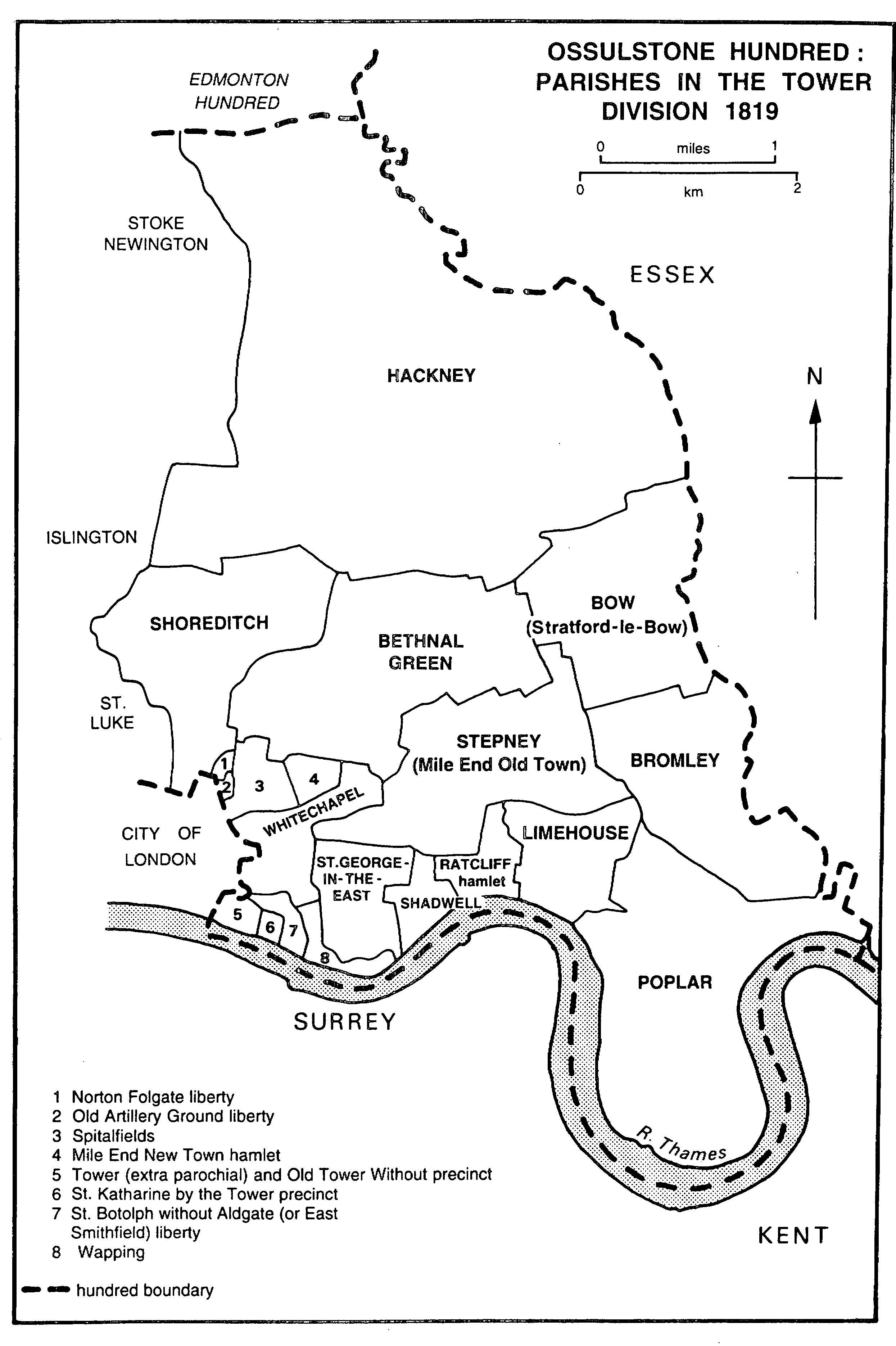
OSSULSTONE HUNDRED
PARISHES IN THE TOWER DIVISION 1819
Hackney, (fn. 1) a favourite residence of wealthy Londoners from the Middle Ages until the 19th century, was the largest Middlesex parish to be included in the county of London in 1889. Near the south-western corner, the bridge bearing Kingsland Road across the Regent's canal was c. 1.8 km. north of the bar of London at Bishopsgate. From the bridge the road, a section of Ermine Street and under various names, led almost due north for 3.8 km. to enter Tottenham at Stamford Hill. For part of its length, as Stoke Newington Road and High Street, it formed Hackney's western boundary, whence the parish stretched eastward for c. 3.6 km. to Temple Mills on the river Lea. Besides Hackney village, the parish included part of Kingsland, Dalston, Shacklewell, Stamford Hill, Upper and Lower Clapton, Homerton, Hackney Wick, and part of Stoke Newington village along the high road.
The area of the parish was estimated with some accuracy at c. 3,300 a. in 1765 and 1831. (fn. 2) A south-westerly projection beyond Kingsland Road had sometimes been described as in the northern part of Hoxton, a manor of Shoreditch, before Hackney and Shoreditch reached agreement in 1697. After building had obscured the field lines, it was confirmed in 1843 that the boundary followed Branch Place and De Beauvoir Crescent across the canal; its course farther east was also established. (fn. 3) Other boundary disputes had arisen with Islington in 1655, 1660, and 1666-7, the last leading to a lawsuit about grazing rights behind Kingsland chapel, (fn. 4) with Bethnal Green in 1732 and again in 1779, when a perambulation was ordered, with Bow in 1806, and with Stoke Newington in 1822. (fn. 5) In 1690 the bounds had not been perambulated for five years. (fn. 6) Although most of the eastern boundary followed the original course of the Lea, c. 65 a. beyond the river lay in Hackney: in the extreme north-east opposite the foot of Spring Hill, at Lea bridge, and at Temple Mills where the boundary was a mill stream, presumably of medieval origin and later a waterworks river. (fn. 7)
Under the Metropolis Management Act, 1855, Hackney became a civil metropolitan parish within the area of the M.B.W. Under the London Government Act, 1899, it became a metropolitan borough of 3,288 a. (1,330.7 ha.), (fn. 8) whereupon the boundaries with boroughs to the west and south were adjusted. The main changes were that Hackney gained houses along the east side of Bethune Road from Stoke Newington and the south side of Ball's Pond Road from Islington, that it surrendered the west side of Southgate Road to Islington, that the Shoreditch boundary was rationalized to run along the canal south of De Beauvoir Town and farther east to follow Albion Road (from 1939 Albion Drive) and Brougham Road, and that the straight boundary with Bethnal Green was made to follow the curve of Gore Road. (fn. 9) A further change was the transfer to Tottenham from 1908 of houses on the south side of Bailey's Lane (later Craven Park Road) in exchange for some on the north side of Vartry Road. (fn. 10) From 1965 the metropolitan borough became part of the London Borough of Hackney, along with Stoke Newington and Shoreditch. (fn. 11)
Alluvium lies along the Lea and beneath Hackney marsh. It is bordered on the west by a narrow strip of London Clay, which broadens out along the Tottenham boundary, covering the north- western tip of the parish and extending south in a shorter strip beneath the G.E.R.'s Enfield branch line to a little beyond Hackney Downs. Brickearth lies beneath Stamford Hill and Clapton common, between the tongues of clay, and farther south intrudes from the west beneath Stoke Newington High Street. The centre and the south-western part of the parish lie on Taplow Gravel, stretching from Lower Clapton and Hackney village along Mare Street and Kingsland Road. Victoria Park and the area around Well Street common are on flood-plain gravel. (fn. 12)
The land rises westward from the Lea, most steeply towards the north-west to reach more than 30 m. above sea level around the top of Clapton common and Stamford Hill. The highest point on the road from London is at 33 m. near Portland Avenue. Thence the road falls steeply towards Tottenham, to 20 m. just beyond the boundary, but more gradually towards the south, to below 25 m. at Stoke Newington station, rising slightly along Stoke Newington Road but dipping to remain at below 20 m. south of Dalston junction. Upper Clapton is mainly above 25 m. and Lower Clapton, like Shacklewell, above 20 m. Hackney Downs lies at 20 m. but to the south and east most of the parish, drained by Hackney brook and minor streams through the gravel towards the Lea, is lower. Victoria Park lies below 15m. and part of Hackney Wick below 10 m. There the almost imperceptible slope to the river contrasts with the abrupt descent farther north, from Upper Clapton: steep roads fall from nearly 25 m. to less than 10 m. at High Hill ferry and from more than 25 m. at the longer Spring Hill. (fn. 13)
The parish was crossed by Hackney brook. (fn. 14) In Hackney its upper stretch, described as Dalston brook in 1745 (fn. 15) and 'the old brook' by 1831, ran along the north side of Stoke Newington common before turning southward to skirt the western side of Hackney Downs and then south-eastward across Dalston Lane to cross Mare Street a few yards south of Bohemia Place. Above Mare Street, immediately south of a garden behind the Mermaid, Hackney brook was joined by Pigwell or Pitwell brook, which flowed from Kingsland green and followed part of the line of the modern Graham Road. (fn. 16) From Mare Street Hackney brook runs north of Morning Lane, giving its name to the curving eastern section once called Water Lane, and the line of Wick Road to Hackney Wick, whence it passed southward to White Post Lane in Bow and so to the Hackney cut and the Lea. The well drained gravel of southern Hackney gave rise to unnamed streamlets, sometimes marked as common sewers and perhaps including a tributary of the brook along the line of Well Street. The long stretches of Hackney brook which remained open in 1857, (fn. 17) north-west and east of Hackney village, had been covered by the M.B.W. by 1861. (fn. 18)
As a much visited resort, Hackney in the 18th century was thought to have given rise to the term 'Hackney horse' and so to the Hackney coaches or chairs which plied for hire. (fn. 19) The place-name, however, was of pre-Conquest origin and unconnected with the occupation of hackneyman, recorded in 1308, (fn. 20) and the French horse called a haquenée. (fn. 21)