A History of the County of Oxford: Volume 4, the City of Oxford. Originally published by Victoria County History, London, 1979.
This free content was digitised by double rekeying. All rights reserved.
'Outlying Parts of the Liberty', in A History of the County of Oxford: Volume 4, the City of Oxford, (London, 1979) pp. 265-283. British History Online https://www.british-history.ac.uk/vch/oxon/vol4/pp265-283 [accessed 19 April 2024]
In this section
OUTLYING PARTS OF THE LIBERTY
Northgate hundred, p. 265. Binsey, p. 268. Holywell, p. 271. Walton, p. 274. Oseney, p. 278. Port Meadow, p. 279. Other meadows, p. 282.
Included within the liberty or suburbs of Oxford were the manors of Binsey, Medley, North and South Oseney, Walton, and Holywell, as well as Port Meadow, and the meadows west of Oseney which were held of the lord of Headington in the 12th century. Much of the liberty was considered to belong to a hundred called Northgate. There were substantial settlements at Twentyacre, near Walton, and at Wyke, south of Medley. Binsey and Medley have remained in most respects distinct from Oxford, and their history is described in full in this section. The other settlements were tied to the town more closely and only their manorial and agricultural history is described here.
NORTHGATE HUNDRED
All the manors within the liberty were at one time or another described as being within Northgate hundred. In 1279 the whole of North Oxford, including Walton, and the meadows west of Oseney, were described under the heading of Northgate hundred; Holywell was omitted, and Oseney, Twentyacre, Medley, and Binsey were included in the north-west ward of the town. (fn. 1) The division between the town and its suburbs made by the juries at 13th-century eyres was similar. (fn. 2) A late-13th-century rental of a third of the hundred, however, included Binsey, (fn. 3) and in 1419 a jury stated that the hundred comprised North and South Oseney, the parishes of St. Mary Magdalen, St. Giles, St. Thomas, and St. George, the hamlets of Walton, Holywell, Binsey, Medley, and Twentyacre, the Castle mill, King's Mead, and a weir and two small islands in the Thames. (fn. 4) Extents of the hundred taken in 1291 and 1346, however, omitted all the land held in chief by the abbess of Godstow in Walton, as well as the meadows beyond Oseney, which by then had become separated from Headington manor. (fn. 5) The extents included only the houses in Broad Street, George Street, the east side of Walton Street, the west side of St. Giles's Street, and the southern half of the east side of St. Giles's Street; in 1291 157 properties owed suit of court, 98 also owed rents, and 59 labour services, apparently at Headington; in 1346 c. 90 properties owed rents to the lord of the hundred. (fn. 6) In the 16th century and later the hundred comprised St. Mary Magdalen parish with a small part of St. Giles's, presumably the houses on the west side of St. Giles's Street. (fn. 7) The bailiffs of the hundred also claimed some jurisdiction over Walton and the meadows west of Oseney, and, in the 16th century, over Holywell. (fn. 8)
It seems that in the 13th and 14th centuries two widely different definitions of the hundred developed, and that in the 16th century there was an effort to reconcile them. Originally, it may be suggested, the name Northgate was given to the area outside the north gate of the town which was attached to Headington manor and which did not form part of Walton. About 1140 Robert d'Oilly informed all his men of Northgate and Headington of a grant of land in Walton. (fn. 9) The name Northgate hundred was first recorded in 1141 or 1142 when the Empress Maud confirmed the possessions of St. Frideswide's priory there. (fn. 10) There is no trace of such a hundred in Domesday Book; the area of Oxford within and without the walls there described presumably included any northern suburb then in existence, and other parts of North Oxford and the meadows west of Oseney were included in Headington manor. (fn. 11) Walton was described in Roger d'Ivri's fee under the obscure heading of the second 'Gadre' hundred; (fn. 12) since that hundred also contained Stoke Talmage (later in Pyrton hundred) and Wolvercote (later in Wootton hundred), it is unlikely to have been the later Northgate hundred, if, indeed, it was a hundred at all. (fn. 13)
The two hundreds whose soke belonged to Headington were Bullingdon and 'Sotterlawa' hundreds, later the double hundred of Bullingdon. (fn. 14) It has been suggested that Northgate hundred was the rump of Sotterlawa hundred which, because of its semi-urban character, was not absorbed into Bullingdon hundred; (fn. 15) but Sotterlawa hundred was recorded as late as 1219, (fn. 16) by which time Northgate hundred was well-established. The argument in any case loses much of its force from the recent identification of 'Sotterlawa' with the lost 'Shoteslawa' in Merton, on the northern edge of the later Bullingdon hundred, instead of with a barrow on Shotover Hill. (fn. 17) It is also possible that Northgate hundred was the foreign hundred of Oxford, and indeed it was described as such in 1261, (fn. 18) but that was the only instance of the term; there is no evidence that Oxford itself was ever the caput of a hundred, and, apart from Colchester, foreign hundreds did not appear north of the Thames. (fn. 19)
In searching for the origins of the hundred more stress should perhaps be laid on the use of the term Northgate hundred to describe a manor outside the north gate, as in the surveys of 1291 and 1346. The origins of the hundred may lie in the splitting off of the agricultural areas of the liberty of Oxford from the urban area, the 'manorialization' of the fields, such as took place at Lincoln and Leicester. (fn. 20) The area left to the lords of Headington manor, called Northgate, could be described as a hundred because the lords claimed hundredal jurisdiction there: the suburb of St. Clement's or Bridgeset, beyond the east bridge, was similarly called a hundred in 1279. (fn. 21) At the time that Northgate hundred was developing 'Sotterlawa' hundred was disappearing, but it was still remembered that the soke of two hundreds belonged to Headington. Thus Northgate hundred was substituted for 'Sotterlawa' hundred as an appurtenance of Headington manor, and jurors and officials, feeling that every settlement should be in a hundred, described the manors of the liberty of Oxford, which did not lie within any other hundred, as belonging to Northgate hundred.
The hundred followed the descent of the manor of Headington, (fn. 22) being held by Hugh Plukenet (d. 1201), then by Thomas Basset (d. 1220), and his eldest daughter Philippe, countess of Warwick (d. 1265). On Philippe's death her property was divided among the three daughters of her sister Alice, wife of John Biset. Hugh de Plessis, husband of the youngest daughter, Isabel, obtained Headington and two-thirds of Northgate hundred, but one-third of the hundred passed to John de Rivers, son of the eldest sister. (fn. 23) Hugh de Plessis surrendered Headington and his share of Northgate hundred to the Crown in 1280; (fn. 24) in 1281 the hundred alone was committed to Henry Dimmock for 10 years, (fn. 25) but in 1299 it was assigned, with Headington, to Queen Margaret in dower. (fn. 26) The reversion of the hundred and manor was granted in 1317 to Richard Damory (d. 1330) (fn. 27) and the hundred passed with Headington to his son Richard (II) Damory (d. 1375) and then to Elizabeth Chandos, Eleanor, wife of Roger Colynge, and Isabel, wife of John Annesleye, the heirs of John Chandos. (fn. 28) In 1390 property in the hundred was held of John Annesleye and Roger Colynge as of Headington manor. (fn. 29) In the later 14th century the town seems to have held the hundred at farm for a time. (fn. 30) The manor and hundred were granted to William Willicotes in 1399, (fn. 31) and remained in his family, passing eventually to William Catesby, one of the heirs of his youngest daughter, who in 1482 granted it to Robert Brome of Holton in exchange for other property. (fn. 32) Robert's great-greatgrandson, George Brome, (fn. 33) sold the hundred to the city in 1592. (fn. 34)
The third of the hundred held by John de Rivers seems to have passed to his nephew William Biset, son of Ela Biset and John of Wootton, who held it in 1285. (fn. 35) It presumably remained in the Biset family, perhaps being held by Adam Biset c. 1320. (fn. 36) In 1497 it was held by Thomas Bulkeley of Eyton (Salop.), who may have acquired it from Thomas Fysshe. (fn. 37) In 1505 Bulkeley sold the property, then known as Bulkeley's or Busset's lands or rents, to William Smith, bishop of Lincoln, who gave it to Brasenose College before 1512. (fn. 38) By his will, dated 1513, Bishop Smith charged the property, then called Basset's fee, with payments for the upkeep of his chantry in Lincoln Cathedral, (fn. 39) and much of it was consequently confiscated as chantry land at the Reformation, the college retaining only c. 50 a. of Botley mead. (fn. 40) Part of the Biset fee, 20 a. meadow and £5 18s. 9d. rent, was confirmed to John Payn and Henry Champness by Thomas Payn and Joan his wife in 1443-4; (fn. 41) in 1468 it was leased to Edward Woodward, and by 1501 it had passed to James Souche, from whom Bishop Smith bought it. (fn. 42)
The hundred court was first recorded between 1154 and 1163. (fn. 43) In 1291 64 tenants owed suit to the three-weekly court, and 73 owed suit twice a year for view of frankpledge, and presumably also when the king's writ was pleaded, a thief judged, or the court afforced for a judgement. (fn. 44) Some borough customs seem to have obtained in the court; in 1277 a tenement was recovered by judgement of 'shortford'. (fn. 45) In 1320 the mayor and bailiffs witnessed a deed executed in the hundred court. (fn. 46) Wills were proved before the court in 1324-40. (fn. 47) In 1323 the farmer of the hundred farmed the assizes of bread and of ale, (fn. 48) and in 1356 Richard (II) Damory as lord of the hundred claimed assay and breaches of the assizes of bread, ale, and wine, the cognizance of all pleas arising in the hundred, and amercements and other profits from those pleas. His right was challenged by the university which was awarded the same extensive privileges and rights within the hundred as it exercised elsewhere in Oxford. (fn. 49)
In 1597 the city leased the hundred with its court, courts leet and view of frankpledge, waifs, strays, felons' goods, and other rights. (fn. 50) From the early 17th century the court met once a year in October for the swearing of juries and the perambulation of the bounds, and was then adjourned for about a month for the admission of tenants, the presentment of nuisances, and the taking of amercements. All adult males, whether freeholders or not, owed suit to the hundred court, as they did to the ward courts of the city, but otherwise the court was indistinguishable from a manor court. (fn. 51) The free suitors included 11 colleges, the churchwardens of St. Martin's, the reeve and four men of Walton, and the reeve and four men of Botley (for Botley mead). (fn. 52) In the later 16th century the hundred bailiff tried to make the tenants of Walton attend the court; (fn. 53) it is not clear whether the attendance of the reeve and four men dated from that time, or whether it was an old custom which the bailiff was attempting to extend to Walton tenants. Less and less business was done in the courts in the 18th and early 19th centuries, and they were discontinued in 1839 because the town clerk considered them a waste of time. (fn. 54)
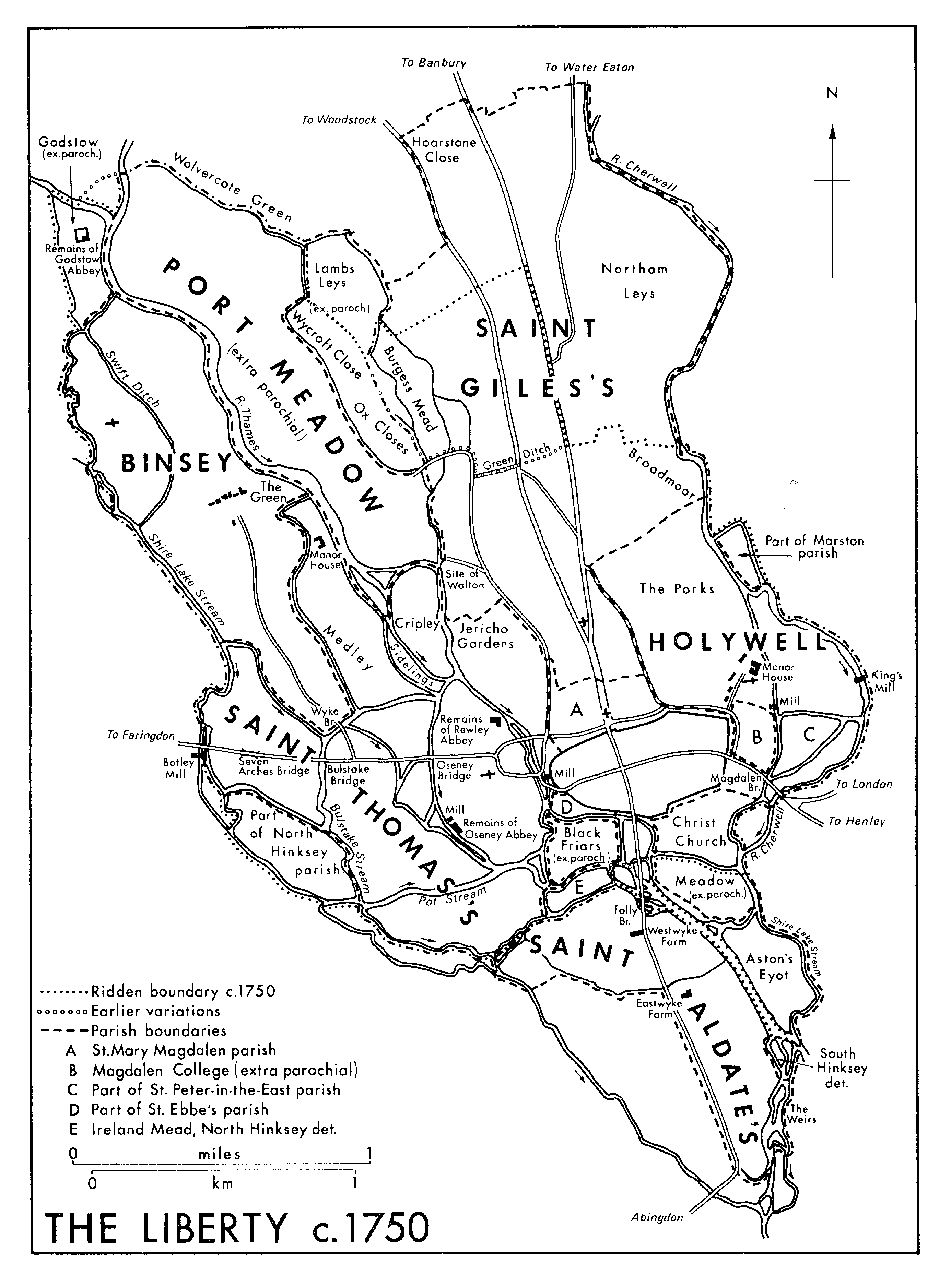
THE LIBERTY c. 1750
William the reeve outside the north gate occurs between c. 1190 and 1200; c. 1240 Simon Balehorn was bailiff of the hundred outside the north gate. (fn. 55) There was a constable of the hundred in 1390, and by 1627 there were two constables and two petty constables. (fn. 56) The hundred had its own coroners in 1285. (fn. 57) It does not seem to have possessed a gaol: malefactors caught in Northgate hundred were imprisoned at Headington in the custody of the Bullingdon hundred bailiff. (fn. 58) In 1627 and 1682 the homage presented the lords of the hundred for failing to provide a pound or stocks. (fn. 59)
BINSEY
The township of Binsey (c. 387 a.) lies north-west of Oxford, bounded on all sides by branches of the river Thames; (fn. 60) it lies partly on the first gravel terrace, partly on river alluvium. (fn. 61) In the 12th century it comprised the islands of Binsey to the north, and Langney to the south. An area around the church in the north-west forms an island, separated from the village by the Swift ditch, and although considered part of Binsey from an early date may originally have been called Thornbury (thorn-tree hill), considered in the 15th century to be an alternative name for Binsey. (fn. 62) South-east of Binsey lies Medley which has been joined to Binsey by modern drainage schemes. Binsey belonged to St. Frideswide's priory from an early date, and was said traditionally to have been given to St. Frideswide herself; there may have been a cell of the priory there c. 1130. (fn. 63) Langney was granted to St. Frideswide's by Oseney abbey c. 1190 and was held of the lord of Northgate hundred. (fn. 64) From 1244 the priory leased Langney to its tenants on Binsey. (fn. 65)
The village lies among river-meadows about a mile north of the built-up area of west Oxford. The houses border a large green; along the north side stands a row of 18th- and 19th-century rubble and brick cottages, roofed with slate or thatch. At the south-west corner is a rubble and slate farm-house, which contains some 17th-century work. To the north-east stands a public-house, the Perch, a two-storeyed rubble building roofed with thatch and slate; (fn. 66) it dates partly from the 17th century, but it is not known how long it has been an inn. It was recorded as the Fish in 1831, and was described in 1842 as 'well-known', (fn. 67) presumably because then, as later, it attracted visitors, on foot and by boat, from Oxford. About ½ mile north of the green lie the church and two small cottages. In the 16th century St. Frideswide's priory owned a house near the church called 'the court'. (fn. 68)
In the Middle Ages there was a settlement known as the Wyke on the south-eastern tip of Langney, close to the modern Wyke Bridge. It was first recorded c. 1190 (fn. 69) and was large enough to be considered a separate hamlet in the late 13th and early 14th centuries. (fn. 70) There was still at least one house on the site c. 1587, but it had disappeared by 1624. (fn. 71)
A lane runs to Binsey green and the church from the Botley road, crossing a stream of the Thames at Wyke Bridge. The bridge was first recorded in the later 17th century and was rebuilt in 1776 or 1777. (fn. 72) It may have replaced a ford next to Swerham for which the bailiff of Binsey paid Oseney abbey ½d. in 1317, although that ford probably lay further east than the later bridge. (fn. 73) The lane from the village to the church was laid out at inclosure in 1821, replacing an earlier footpath through the fields; other footpaths led from the church to Wytham and Godstow. (fn. 74) There was a ford across the river to Port Meadow, (fn. 75) and the inhabitants of Binsey claimed to have a right of way for their carts and cattle across the meadow towards Oxford. (fn. 76)
In 1381 44 Binsey inhabitants were assessed for poll-tax, although 7 bore the surname atte Wyke and may have come from that settlement; others may have been from Medley. (fn. 77) In 1524 only 5 men were assessed for subsidy, one at the comparatively high rate of 5s. (fn. 78) In 1648 13 were assessed, including Mr. Perrot, the tenant of the manor. (fn. 79) In 1662 38 hearths were taxed, and in 1665 31, of which 9 were in Thomas Crutch's manor-house at Medley. In 1668 48 people paid poll-tax. (fn. 80) In 1773 there were 11 houses in Binsey, 5 of them in disrepair, and a twelfth house had fallen down some years earlier. (fn. 81) The population rose from 55 in 1801 to 82 in 1821, declining slightly thereafter; in 1921, the last year for which a separate figure is available, it was 63. (fn. 82) In 1974 it was fewer than 30. (fn. 83) Most of the 18th- and 19th-century inhabitants were poor; in 1793 there were only one or two moderate farmers, and in 1904 the vicar asked help from Christ Church because there were no resident gentry to support clothing, coal, and other benefit clubs. (fn. 84)
Medley, although technically part of St. Thomas's parish, has been closely connected with Binsey throughout its history. Its inhabitants seem to have been entered with Binsey in medieval and early modern taxation records, (fn. 85) and some were buried in Binsey churchyard. (fn. 86) There were 2 cottagers at Medley in 1279 (fn. 87) and later the settlement seems to have comprised only the manor-house and associated buildings. In 1509 the house was assigned to the abbot of Oseney as his residence. (fn. 88) A boatyard on the Thames at Medley dates from the late 19th century. (fn. 89)
Their nearness to Oxford, at the end of a popular walk across Port Meadow, has made Binsey and Medley familiar to Oxford people of both town and university. Medley was a popular eating place; some 17th-century verses celebrated 'A place at which they never fail/Of custard, cyder, cakes and ale,/Cream tarts and cheese-cakes, good neats' tongues,/And pretty girls to wait upon's'. (fn. 90) Similar food and drink was served in 1767 at the Cheese Cake, adjoining the manor-house. (fn. 91) The unspoilt rural nature of the site attracted other visitors, including Gerard Manley Hopkins who lamented the felling of the 'Binsey Poplars' in 1879. (fn. 92)
MANORS.
BINSEY was confirmed to St. Frideswide's priory at its refoundation in 1122, and, like the other properties of the earlier house, was taken by Roger, bishop of Salisbury, and restored in 1139. (fn. 93) The priory's possession of the island seems to have been disputed by the townsmen of Oxford in 1139, (fn. 94) presumably because it was claimed to be part of Port Meadow, but thereafter the priory's title was unchallenged.
Langney was granted to Oseney abbey by Geoffrey de Clinton before c. 1143, (fn. 95) and, after a dispute over ownership, was granted by the abbey to St. Frideswide's between c. 1190 and 1200. The grant was confirmed by Hugh Plukenet as lord of the Northgate hundred, in which Langney lay. (fn. 96) In 1388, after a further dispute, Oseney remitted to St. Frideswide's a rent of 20s. a year from Langney. (fn. 97)
In 1279 the prior of St. Frideswide's held Binsey, assessed at ½ hide, and Langney, described as 'a meadow behind Oseney', of Hugh de Plessis at yearly rents. (fn. 98) By the end of the 13th century, however, the properties and rents seem to have been combined. (fn. 99) At the dissolution of St. Frideswide's Binsey passed with the priory's other possessions to Cardinal College, then, in 1532, to Henry VIII's College, and in 1546 to Christ Church. (fn. 100) It was then described as Binsey manor with appurtenances in the vill and fields of Binsey with Wyke, and St. Margaret's Well. Robert Perrot (d. 1550) acquired a 60-year lease of the manor, granted in 1518, and a grant of the reversion for 80 years from the expiry of the first lease. His son John (d. 1572), left two-thirds of the property to his brother Leonard and a third for various charitable purposes. (fn. 101) On the expiry of the first lease in 1578 Christ Church attempted to recover the property, but agreed in 1588 to lease two-thirds of the manor to Leonard Perrot for three lives. (fn. 102) The lease was renewed in 1624-5, but by 1680 the whole manor was in the hands of Christ Church. (fn. 103)
In the late 13th century it was said that WYKE had been included in the burgesses' grant of Medley to Oseney in 1147, (fn. 104) and in 1313-14 the abbot and convent were lords of Wyke. (fn. 105) In 1388 St. Frideswide's released to Oseney the rent of and suit of court from a croft at Binsey called Reynold's Wyke, perhaps identical with Wyke, (fn. 106) but there is no further record of Oseney's interest in Wyke, and it was included with Binsey in the grant to the bishopric of Oxford in 1546. (fn. 107)
MEDLEY seems to have been part of the burgesses' common pasture of Port Meadow. In 1138-9 the burgesses granted it to St. Frideswide's in exchange for land in the town, but in 1147 they gave it to Oseney. (fn. 108) The ensuing dispute between Oseney, St. Frideswide's, and the burgesses was settled in 1191 when the burgesses agreed to pay St. Frideswide's a yearly rent for Medley, and then granted the island to Oseney at a slightly lower rent. (fn. 109) In 1279 the abbot of Oseney was returned as holding the land and meadow of Medley, (fn. 110) and the island was again confirmed to Oseney, after a further dispute with St. Frideswide's, in 1388. (fn. 111) Med ley was first described as a manor in 1356. (fn. 112) The estate, then held by Henry Royse for a term of years, was among the former Oseney properties granted to the bishopric of Oxford in 1546. (fn. 113) It was taken from the bishopric by Elizabeth I, and in 1575 granted to John Herbert and Andrew Palmer of London. (fn. 114) The manor was later held by the Spencer family of Yarnton, to whom the occupant of the manor-house paid rent in 1712-13, (fn. 115) and from whom it passed, probably by sale, to Benjamin Sweet (d. 1744) who was said to have built a house at Medley c. 1723. (fn. 116) From Sweet the manor presumably passed to his heir at law Adrian John Sweet of Train (Devon), a bequest for charitable purposes having been found invalid. (fn. 117) A. J. Sweet presumably sold the estate which was then held by a succession of owners, many of whom ran the house as a public-house. (fn. 118) In 1811 it was described as Medley Farm. (fn. 119) In 1829 the estate was in the possession of William Tuckwell, (fn. 120) and in 1861 the manor and the estate, which included copyhold land in Binsey and in St. Thomas's parish as well as the freehold land at Medley, was sold at auction and acquired for Christ Church. (fn. 121) Christ Church sold the property, then known as Medley manor farm and comprising c. 120 a., in 1954. (fn. 122) Benjamin Sweet's house, according to an early 18th-century print, (fn. 123) had a symmetrical east front of 5 bays and stood in a walled garden running down to the river. It is hard to reconcile such a house with that which survived in 1975 which was probably the eastern end of a 17th-century house with a mid18th-century service wing on the north-west, unless the elevation depicted is that to the south. The garden wall is largely of re-used stone, including some 12thcentury voussoirs with chevron and beak-head ornament.
AGRICULTURE.
In 1279 the prior of St. Frideswide's had 21 villein tenants at Binsey of whom 14 owed labour services from Midsummer to Michaelmas. (fn. 124) The services were later described as mowing the meadow of Presteit, making hay with one labourer for a day, carting hay with one man from Midsummer to Michaelmas, and working three times a week with one labourer, except for the three autumn boon works; the villeins also owed 'sant', langafol (rent), ingafol (rent), churchscot, and tolcestre (a toll on ale). (fn. 125) In 1378 the priory had leased the whole of its southern meadow of Binsey (presumably Langney) and 'hok' (presumably Wyke) to Robert Watlington, an Oxford butcher, presumably for grazing. (fn. 126) Much of Binsey and the whole of Langney and Medley was meadow, and the inhabitants also held rights of common on Port Meadow, where their cattle were sometimes looked after by a herdsman employed by the village. (fn. 127)
The arable land lay to the north and west of Binsey village. (fn. 128) A yardland there c. 1739 consisted of 12 a. arable and 6 a. meadow in the common field. (fn. 129) In 1800 the arable was in a bad state of cultivation: it was cropped every year, and in many places floods destroyed the corn half way up the furrows. Flooding had also impoverished some of the grassland. (fn. 130) By 1818 the common field was 'in a shocking condition' from flooding, and 'almost useless' because of the way in which it was farmed; holdings were dispersed in a great many small pieces, the field was commonable until 15 November, although wheat should have been sown before that, and it was divided into 8 or 9 furlongs, so that nearly one-eighth of it was taken up in headlands. (fn. 131) In 1821 the 120 a. of common field were inclosed, all copyholds having been surrendered to Christ Church, who thus owned the commons absolutely. (fn. 132) After inclosure an increasing amount of arable was converted to pasture (fn. 133) and by 1975 there was very little arable left.
LOCAL GOVERNMENT.
In 1139-40 the burgesses of Oxford acknowledged that the canons of St. Frideswide's had their hundred in all things at Binsey; (fn. 134) in 1376 the canons claimed lordship and franchise and held courts leet for their tenants there. (fn. 135) The liberties apparently included a gallows. (fn. 136) Christ Church chapter likewise claimed court leet, court baron, and view of frankpledge, and continued to hold courts until 1835. (fn. 137) The court's main business was admissions to and surrenders of copyholds, but 17thcentury courts made by-laws governing the commons and the common field, and appointed a constable, tithingmen, and fieldsmen. (fn. 138)
Binsey was a separate unit for poor law purposes. Expenditure rose from £19 18s. 6d. in 1776 to £70 5s. 7d. in 1803 and £91 10s. in 1821. (fn. 139) After 1834 it was in the Abingdon Union. (fn. 140)
CHURCH.
Binsey chapel perhaps owed its existence to St. Margaret's well, presumably the holy well associated with the legend of St. Frideswide, (fn. 141) which is in the churchyard, just west of the church. The chapel was confirmed to St. Frideswide's in 1122 (fn. 142) and remained dependent on the priory throughout the Middle Ages. In 1341 it was attached to St. Edward's parish, (fn. 143) with which St. Frideswide's parish had been amalgamated in 1298. As late as 1552 Binsey had no burial rights, bodies being taken by river to Oxford for burial, but by 1558 there was a graveyard. (fn. 144) Until at least 1801 Christ Church treated the chapel as a peculiar; in 1752, for instance, the college forbade the churchwarden to attend the archdeacon's visitation. (fn. 145) In 1801 the living was described as donative, in 1856 as a perpetual curacy, and from 1891 as a vicarage. (fn. 146)
The living was taxed at 6s. 8d. in 1291, (fn. 147) but was not valued in 1535. In 1423 St. Frideswide's was ordered to give to the canon who served Binsey food and clothing for himself and his servant and 'honest living and support'. (fn. 148) In 1558 Christ Church paid a third of the curate's salary, Leonard Perrot the rest. (fn. 149) The living was augmented by Queen Anne's Bounty with grants of £200 each in 1743, 1750, and 1793 to meet benefactions from Christ Church; (fn. 150) in 1778 it was worth £53 a year, in 1802, £110, and in the late 19th century between £70 and £95. (fn. 151)
Simon, chaplain of Thornbury, imprisoned in Oxford in 1293, was the only recorded medieval chaplain. (fn. 152) After the Reformation almost all the chaplains or curates were students of Christ Church. John Singleton, appointed in 1659 and expelled from his studentship in 1660, later became a nonconformist preacher. (fn. 153) Some later curates were eminent, but their stay at Binsey was usually brief and they probably had little to do with the village. (fn. 154) J. A. Cramer, curate 1822-45, regius professor of modern history, began a period of longer incumbencies, and his successor Robert Hussey (1845-57), regius professor of ecclesiastical history, took his cure seriously and visited regularly. (fn. 155)
In the early 19th century there was one Sunday service and Holy Communion was administered four times a year to c. 10 communicants; the parishioners attended regularly. (fn. 156) In 1854 the Sunday service was attended by c. 20 people, and Holy Communion was administered once a month to c. 5 communicants; there was 'much godless apathy' in the village. (fn. 157) Congregations, described as very small and 'very far from learned', at times fell as low as 5 or 6, but increased after the restoration of the church in 1875. (fn. 158) The living was held in plurality with Wytham (Berks.) from 1919 to 1950, thereafter with St. Frideswide's, Oxford.
The church of ST. MARGARET comprises a chancel, nave, and south porch, as did the 12th-century church, of which the south door and the door jambs of the south porch survive. It was partially rebuilt in the 13th century when a central bellcot was added, windows inserted in the west and south walls, and a doorway, later blocked, in the north wall. In the 14th century the chancel arch was rebuilt and the chancel reroofed; in the 15th century the east and south windows of the chancel and the west window in the nave were inserted and the nave was probably reroofed. (fn. 159) A ceiling, later removed, seems to have been made in 1718, and in 1721 the bellcot was rebuilt to its original design. (fn. 160) The chancel was repaired in 1833. (fn. 161) The whole church was restored in 1875, (fn. 162) and repairs were carried out in 1933 and 1963. (fn. 163) In 1975 the church was unheated and lit by candles.
Monuments include those to Richard Tawney (d. 1756), and his sons Sir Richard (d. 1791), and Edward (d. 1800), all mayors of Oxford. Queen Anne's arms are displayed. The 12th- or 13th-century plain cylindrical font has a modern base. In the east window are fragments of 14th- and 15th-century glass. (fn. 164) The plate includes a silver chalice and paten-cover given by Daniel Porter in 1690. (fn. 165)
SCHOOLS.
A Sunday school was first recorded in 1814, (fn. 166) and William Corne, a former curate, by will dated 1818, left £100 for its support. (fn. 167) In 1823 there was a day-school, but it had closed by 1833, when only 2 boys and 8 girls attended the Sunday-school. (fn. 168) In 1846 a former curate, John Bull, gave a further £100, the income to be used for the parish school, and in the same year Corne's legacy was invested by Christ Church. (fn. 169) The Sunday-school continued, although in 1854 the curate reported that few of the children in the village were old enough to learn anything. (fn. 170) In 1878 a dame school was being run, at the vicar's expense, for the younger children; older children attended schools in Oxford. (fn. 171) Binsey was included in the Oxford School Board area in 1872.
HOLYWELL
The small parish of Holywell or St. Cross (c. 235 a.) lies immediately north-east of Oxford, beside the river Cherwell. Its church was throughout the Middle Ages a chapel of St. Peter-in-the-East, but the manor seems to have been quite distinct from Oxford in 1086, (fn. 172) and to have remained so until 1667. Claims in 1279 and 1285 that Holywell was within the town's liberty were unsuccessful, (fn. 173) and in 1315 the town failed to force the men of Holywell to do suit to its guild. (fn. 174) In 1349 the homage of the manor court stated that tenements in Holywell were not of the tenure or custom of the vill of Oxford, and in 1549 that the manor was not part of the vill or suburbs of Oxford. (fn. 175) In 1338, however, a suit between Merton College, lord of the manor, and the Augustinian friars over property outside Smithgate was heard in the town court, and Merton pleaded the custom of the town. (fn. 176) The bailiff of Holywell prevented the city coroner from holding an inquest in the manor c. 1285, and Merton protested at similar inquests in 1607 and 1622. (fn. 177) In 1383, however, the coroner of Northgate hundred held an inquest on a friar found dead in Holywell field, (fn. 178) and Holywell was assessed with the town and its liberty for taxes until the hearth tax. (fn. 179) There were further disputes over 'the liberty of Holywell' in 1619 and 1662-3, and in 1667 it was decided in the King's Bench that Holywell was part of the city. (fn. 180)
The parish bounds, first described in 1315, ran from Smithgate to 'Rome' at the junction of the modern Parks Road and Norham Gardens; thence to the river Cherwell and along the river to the garden of St. John's hospital; thence to Crowell at the north-east corner of the town wall, and along the line of the wall to Smithgate. (fn. 181) The inclosure of Magdalen College grove in the later 15th century caused the southern boundary to be moved slightly further north to follow the line of the new wall. (fn. 182) The section of the boundary along the town wall was frequently in dispute. In 1377 it was agreed that forfeitures arising between the outer bank and the inner wall of the town defences should be shared between the town bailiffs and those of Holywell; in 1383 the mayor swore not to interfere in Holywell, and the agreement of 1377 was confirmed in 1385. (fn. 183) A dispute between 1475 and 1484 about the town's right to dig a ditch outside the outer bank was apparently settled in Merton's favour. (fn. 184) The building of houses in the town ditch in the 16th century led to fresh disputes, and in 1583 the city ordered a search for the foundations of the wall at Smithgate to establish the boundary. (fn. 185)
The church (fn. 186) and manor-house lie roughly in the centre of the parish near Holywell mill-stream; the holy well or spring from which the parish took its name (fn. 187) seems to have been that immediately north of the church, known in the 18th and 19th centuries as the cold bath. (fn. 188) North-east of the manor-house, beside the river, was the cockpit, a circular building with a steeply pitched roof. (fn. 189) The parish was crossed by two roads; one, later Longwall Street and St. Cross Road, led from outside the town's east gate to the church; the other was Holywell Street and its eastward extension, Benseval, which led to Holywell mill; Benseval Street was taken into Magdalen College grove in the later 15th century. (fn. 190) The roads crossed each other at the north-east corner of the city wall by Crowell (crow's spring), which survived until the later 17th century; at the cross roads was a stone cross. (fn. 191) A place called Alms-house, recorded in the later 14th century, (fn. 192) may have been connected with one of the religious houses, the hospital of St. John, or the Augustinian friary, or possibly with the unidentified St. Peter's hospital recorded in 1338. (fn. 193)
In 1068 23 men held gardens in Holywell; (fn. 194) presumably they supplied the Oxford market. In the 13th century there were houses on the corner of the modern Parks Road and Holywell Street, along the north side of Holywell Street, and in Benseval Street, around the edge of the town. The settlement seems to have been largely, in fact if not in law, a suburb of Oxford. In 1377 48 people were assessed to the poll tax, including 15 servants of St. John's hospital, and in 1381 15 were taxed (excluding the 12 servants of St. John's hospital); none was engaged in agriculture. (fn. 195) In 1524 13 men were assessed to the subsidy, 6 of them servants of the two William Clares, lessees of the manor-house. (fn. 196) In 1665, by which date several houses had been built in the town ditch and on the north side of Holywell, 52 people were taxed on 244 hearths, and 12 were discharged by poverty on 24 hearths. (fn. 197)
MANOR.
In 1086 the church of St. Peter-in-the-East held HOLYWELL of Robert d' Oilly, (fn. 198) and the manor passed to successive rectors (fn. 199) until the church was appropriated by Merton College in 1294. (fn. 200) Throughout the 14th century the college kept Holywell in its own hands, administering it through a bailiff, but from at least 1403 the demesne was leased to farmers who included two Oxford butchers. (fn. 201) In 1531 Merton leased the manor to Edward Napper or Napier (d. 1558), (fn. 202) in whose family it remained until the end of the 17th century. (fn. 203) In the earlier 18th century the manor was administered by bailiffs, some of whom lived in the manor-house. (fn. 204) Later the demesne was leased to absentee landlords. (fn. 205)
The manor-house stands north of the church, at the junction of the modern Manor Road and St. Cross Road. In the 14th century the buildings of the court (curia), surrounded by a wall, included a hall, solar, chamber, and kitchen, a separate oven or bake-house, and outhouses including two granges, one built in 1292; a vinery was recorded in 1292, and a dovecot near the kitchen in 1338. (fn. 206) At least four gates led into the curia, one of them the great gate with a room over it. (fn. 207) In 1516 Merton built a new farm-house of two storeys with a hall and parlour, (fn. 208) which survived, much altered, in 1975 as the Balliol praefector's lodging. It had a passage entry, hall, parlour, and service room; a stair turret projecting from the south wall between the hall and parlour gave access to the upper floor and attics. The house was enlarged between c. 1555 and 1572 by Philip Huckle (fn. 209) who added north wings at both ends of the old house, and perhaps also a north range to complete a courtyard plan. The house was not occupied by the lessees after 1671, and in the mid 18th century it was converted into a workhouse. (fn. 210) In 1761 the derelict north-east corner was demolished, and in 1828 the house was divided into three tenements. (fn. 211) The sisters of the community of St. John the Baptist, Clewer (Berks.), tenants of the house from 1862 to 1929, restored the building and added a new north range. (fn. 212) Balliol College, tenants from 1930, made further alterations, demolishing the 19thcentury additions except for a wall containing Decorated windows on the south of the site, and adding in 1938 a north-east quadrangle, in neo-Georgian style on the east but in gabled and stuccoed style where it adjoined the 16th-century house. (fn. 213)
AGRICULTURE.
In 1086 there was land for one plough in Holywell, and 1½ plough working there; 23 men held gardens, and there were 4 a. meadow. (fn. 214) Presumably then, as in the later Middle Ages, almost the whole parish was held in demesne by the rector of St. Peter-in-the-East.
In the mid 14th century there were three ploughs on c. 132 a. of demesne arable, which formed a solid block of nine furlongs and three smaller pieces of land between the Cherwell and the modern Parks Road. (fn. 215) It was not divided into fields, but at least one furlong seems to have been left fallow each year, and some system of crop rotation was probably followed. Manuring was also practised; c. 1335 a lease of 1½ a. arable stipulated that the tenant should manure ½ a. each year, (fn. 216) and among the equipment on the demesne in 1341 were three sledges for carrying dung. (fn. 217) The main crop grown on the demesne was barley: c. 82 a. in 1340, c. 88 a. in 1343, c. 95 a. in 1346, and c. 82 a. in 1360; one furlong was usually sown with wheat and one with rye, and small quantities of dredge, peas, beans, and vetch were grown. (fn. 218) In the 14th century the sale of corn was the major element in the economy of the manor. It was normally sold in Oxford; but in 1391 the bailiff noted that 86 qr. of barley had been taken to Woodstock and Abingdon for sale because it had been burnt in the ricks and no one in Oxford would buy it. (fn. 219)
Livestock, particularly cattle, played an increasingly important part in the economy of the manor both as meat and as dairy animals, and cheese, eggs, butter, and milk from the dairy were sold in most years. Cows and bullocks were also sold regularly, presumably for meat, and bullocks or oxen and pigs were sometimes brought from other Merton estates for sale in Oxford. No sheep were kept on the demesne in the 14th century. (fn. 220)
Wages in money and kind were usually paid to two carters, two ploughmen, one or two drovers, and a cowherd. A swineherd was paid in 1297, and a dairyman in 1333. (fn. 221) Labourers were paid for reaping corn and for making hay in the demesne meadows of Bradmore, Frogmore, Mill meadow, Boleham or Milnesham, Oxlease, and the 'hoke', although most harvest work was task work until c. 1360. (fn. 222)
Most tenants of the manor and of St. John's hospital in the parish were cottagers cultivating gardens of c. ½ a. adjoining their houses where they kept a few animals and grew corn, vegetables, and herbs. (fn. 223) A few held acre or ½-acre strips in the fields, mainly in the Mill croft by the mill and elsewhere in the south-east of the parish, (fn. 224) or later, after the grant of much of Mill croft to St. John's hospital in the later 13th century, in Parish close north of Holywell Street. (fn. 225) The largest recorded holding was 6 a. and 2 butts which belonged to two houses in 1416. (fn. 226)
Most tenants kept pigs; in 1337 as many as 54 pigs and 8 sows strayed into the demesne corn. (fn. 227) Tenants' sheep and cattle were also recorded in the 14th century, (fn. 228) and sheep became increasingly important in the 15th and early 16th centuries: in 1446 flocks of 30 and 40 sheep strayed into the corn, and in 1549 a butcher had 30 sheep; in 1544 there was a manorial shepherd. (fn. 229)
On the demesne the change from direct management by the college bailiff to leasing to farmers seems to have led to a greater emphasis on livestock, and in particular to the introduction of sheep, 100 of which were stolen from the lord's park in 1450. (fn. 230) The butchers who were tenants of the demesne in the later 15th and 16th centuries, presumably used much of the land for grazing, and by 1672 there were c. 152 a. of permanent grass in demesne and only c. 34½ a. of arable. (fn. 231)
In 1336 a jury found that the warden of Merton, as lord of the manor, should have his several pasture in land in Holywell from harvest until it was sown again. (fn. 232) Rights of common were first recorded in 1544 when a horse common was worth 2 cow or sheep commons. In 1581 the manor court restricted the right of common for cattle to those who held land by their houses on which to keep them when the common was not open, limited the number of hog commons to 5 for each tenant, and forbade the selling of commons to foreigners, or the keeping of any horse except the mill-horse on the common. (fn. 233) Frequent orders were made that pigs should be ringed and should not be pastured in the fields. (fn. 234) In 1654 the court limited the use of the common to a total of 19 beasts. (fn. 235) Cow commons were attached to lands in Parish close, one common for each land, in the 17th and 18th centuries. (fn. 236) By the early 19th century the common (c. 5½ a.) was subject to commonage for 21 cows, although it was inadequate for a third of that number, and c. 1818 the college surveyor recommended extinguishing the commons. (fn. 237)
Much of the demesne seems to have been inclosed at an early date; the lord's park was recorded in 1354 and 1450, (fn. 238) and New Park close c. 1430. (fn. 239) In 1455 a tenant was presented for breaking the lord's 'land' at Irishman's pool and making great waste, (fn. 240) and in 1572 all tenants were ordered to make the lord's park sufficiently. (fn. 241) Between 1691 and 1758 the Parks doubled in size, from 42 a. to 79 a., taking in the arable on the west and north of the parish. (fn. 242) In 1607 Merton agreed that the tenants might inclose their land in Parish close, and the inclosure, which had begun by 1616, seems to have been complete by 1672. (fn. 243) In the 18th century 9 lands in the close belonged to 8 tenements on the north side of Holywell Street. (fn. 244)
The amount of arable on the demesne seems to have increased in the earlier 18th century; in 1758 c. 79 a. of the New Parks, 42 a. of which had been pasture in 1672, was arable. (fn. 245) In 1789, however, Merton allowed its tenant to put down a portion of the demesne to grass, and by 1801 there was no arable left in the parish. (fn. 246) The parish was still largely agricultural in 1849 when the pound was 'absolutely necessary' for keeping stray cattle, (fn. 247) but in 1854 91 a. were sold to the university for the Parks, (fn. 248) and by 1876, although there were still c. 85½ a. of pasture in Holywell, the development of South Parks Road had begun. (fn. 249) By the early 20th century most of the parish had been built up or was used as playing fields.
COURTS.
The liberties of Holywell were extensive. In 1086 the manor paid no geld or other dues. (fn. 250) Bevis de Clare, rector of St. Peter-in-the-East, claimed gallows there in 1279, and in 1285 showed that his predecessors had enjoyed the same liberty. (fn. 251) In 1337 a thief was condemned to death by the manor court and hanged, (fn. 252) and Merton established its right to a gallows in 1377. (fn. 253) The gallows, in Longwall, survived until the later 18th century when they were known as 'gownsmen's gallows'. The college, and presumably its predecessors, also claimed return of writs, felons' goods, escheats, and waifs and strays, and kept the assizes of bread and of ale and of weights and measures. (fn. 255) View of frankpledge and a three-weekly court, first recorded in 1271, were held by the bailiff; (fn. 256) wills devising property within the manor were proved before the court and pleas of debt were heard. Offences presented in the 14th and 15th centuries included blood-shedding, house-breaking, breach of the peace, and receiving thieves and stolen goods. (fn. 257) The most common offences, however, were agricultural ones, particularly allowing animals to stray into the corn. The constable and tithingman were elected annually, and some tenants were admitted to tenements. (fn. 258) In the 16th and 17th centuries the court made several by-laws, mainly about the use of the common, but in the 18th and 19th centuries the chief business was the presentment of nuisances. The last court was held in 1864. (fn. 259) In the 16th and 17th centuries the university claimed leet jurisdiction in Holywell. (fn. 260)
There was a manorial prison in 1292 when two prisoners died there, but as other prisoners were taken to Oxford Castle gaol it appears that Holywell, like other manorial prisons, could not keep prisoners for more than about three days. (fn. 261) A house called the prison, recorded in 1616, seems to have been on the north side of Holywell Street. A pillory, recorded c. 1270, seems to have been in the same area, perhaps at the corner of Longwall Street and St. Cross Road where the stocks stood until the 19th century. (fn. 262) In 1556-7 the homage instructed Merton to provide a tumbril, (fn. 263) and in 1604 the tenants were amerced for not having a cucking-stool or stocks in the manor. (fn. 264)
WALTON
Walton was first recorded in 1086; (fn. 265) the first element in the name is probably 'wall', (fn. 266) and suggests that the settlement dated from the 10th or early 11th century, after the walling of Oxford. The village, which may have begun as simply one of a number of farmsteads scattered over the gravel terrace north of Oxford, lay about ½ mile north-west of Oxford near the modern Walton Well Road; (fn. 267) by the late 14th century Oseney and Godstow's two manors of Walton covered almost the whole of St. Giles's parish. (fn. 268) In 1279 there were c. 46 dwellings in Walton village, and the abbot of Oseney held a further 5 cottages in Buricroft, near the site of the Radcliffe Infirmary. (fn. 269) The abbot's grange at Walton, presumably on the site of the later manorhouse, was recorded in 1306. (fn. 270) It lay on the west side of the high road, the modern Walton Street, and the tenants' cottages seem to have extended southwards along the same street. The street, or perhaps the settlement, was known as Walton hamel in the 14th century. (fn. 271) In 1381 49 persons paid poll tax, (fn. 272) but by 1541 there were only 8 tenants on Godstow's manor, and none, except presumably for the occupant of the manor-house, on Oseney's. (fn. 273) By the 1660s Walton was deserted, except for a farm, (fn. 274) perhaps the former Oseney manor-house. In 1556 there was an affray at Walton when the city coroner attempted to hold an inquest there, the bailiff of Northgate hundred claiming that it was within his jurisdiction. (fn. 275)
Another small settlement lay near the modern Jericho, in St. Thomas's parish. By 1279 there were 39 cottages in Twentyacre Close and c. 39 houses and cottages on the west side of Stockwell Street. (fn. 276) By 1377 Stockwell Street with Twentyacre was a separate hamlet or tithing, and in 1381 24 persons paid poll tax there. (fn. 277) The hamlet was recorded in 1418, (fn. 278) but had disappeared by 1510 when only a cottage and garden leased to Oseney abbey's shepherd were recorded there. (fn. 279)
MANORS.
In 1086 Roger d'lvri held a manor in WALTON assessed at 4 hides. (fn. 280) He or his successors seem to have granted it to the church of St. George in the castle, to which Henry I confirmed 3 hides in Walton c. 1127. (fn. 281) The fourth hide may be represented by Twentyacre, apparently also granted to St. George's in Henry I's reign. (fn. 282) The manor passed with the other possessions of St. George's to Oseney abbey in 1149. (fn. 283) The abbey added to its Walton estate before 1199 when Niel the dean gave Buricroft, which his father had acquired between 1154 and 1163 from Hugh Plukenet, lord of Northgate hundred. (fn. 284) In 1279 the abbot of Oseney held in Walton 13 tenements and 12 cottages of the gift of Henry d'Oilly, a croft of the gift of William the dean, and 4 furlongs of the king's demesne, as well as his property in Twentyacre and Stockwell Street. (fn. 285) In the 14th century the abbot held tenements in North Oseney and Walton which used to answer for ½ knight's fee. (fn. 286) In 1541 the manor and 4 closes in Walton were granted by the Crown to George Owen of Godstow, the king's physician. (fn. 287)
A hide in Walton was confirmed to St. Frideswide's priory in 1122, was taken by Roger, bishop of Salisbury, and restored to the priory in 1139. (fn. 288) It was presumably one of 4 hides close to Oxford which paid no geld and belonged to no hundred, and which the canons of St. Frideswide's held in 1066 and 1086. (fn. 289) Between c. 1210 and 1228 the priory granted the hide to William son of Niel the dean, whose family already held a ploughland in Walton. (fn. 290) William gave all his Walton property back to St. Frideswide's before 1235 in return for a corrody, the payment of his debts, and a lease for life of the principal house at Walton with its garden and meadow. (fn. 291) In 1241 the canons received further land in Walton from Simon Balehorn, (fn. 292) but between c. 1250 and 1260 they exchanged it and other land in North Oxford with Godstow abbey. (fn. 293) St. Frideswide's was not returned as holding any land in Walton in 1279, but its holding there may be represented by 3 houses and land in the fields and meadows worth c. £10 5s. a year which the priory held in Northgate hundred. (fn. 294) In 1358 St. Frideswide's exchanged most its remaining lands in Walton and Northgate hundred with Godstow, and the remnants of the property had been lost by the earlier 15th century. (fn. 295)
Godstow abbey built up a manor in WALTON during the 12th and 13th centuries. At its foundation Henry I granted the abbey 100s. worth of his demesne in Walton, (fn. 296) and c. 1154 Henry of Oxford gave a hide in Walton which he had acquired from Geoffrey de Clinton (fl. 1166). (fn. 297) All that land seems originally to have been part of Headington manor. (fn. 298) Between c. 1250 and 1260 and in 1358 Godstow acquired the bulk of St. Frideswide's estate in Walton. (fn. 299) In 1279 the abbey held 7 'hearths', 13 houses, 134 a., and 3 ploughlands in Walton in demesne, and received £12 9s. 5d. rent from other lands in the meadows and fields. (fn. 300) When the manor was granted to George Owen of Godstow in 1541 it comprised 4 houses, 3 cottages, more than 5 yardlands of arable, and a fishery in the Cherwell. A house in St. Giles's with appurtenant arable and meadow formed a separate estate. (fn. 301) Both manors of Walton passed from George Owen to his son Richard who in 1573 sold them to St. John's College. (fn. 302)
AGRICULTURE.
The arable and meadow of St. Giles's and St. Mary Magdalen parishes was by 1086 divided between the manors of Walton and Headington; it may once have formed the fields of an agricultural settlement at Oxford, but the only suggestion of a connexion between the medieval town and the fields is a late-14th-century reference to 'the butts of the free men of Oxford' by the path to Water Eaton. (fn. 303) Along the river Cherwell, the meadows of Bradmore, Wivelseye, Northam, Linches, Puttmede, and Halkwere belonged to Headington manor throughout the Middle Ages, and were usually held by tenants of that manor. (fn. 304) In the 12th and 13th centuries the arable was usually called the field or fields outside the north gate; (fn. 305) the name Walton field occurs in 1199, (fn. 306) but was not generally used until the end of the 13th century. The land east of the Banbury road was called Beaumont field from c. 1260, (fn. 307) but in the 14th and 15th centuries the whole of North Oxford was called Walton field. (fn. 308) In 1407 an estate was said to be in the vill, suburbs, and fields of Oxford and the name Oxford field was recorded in 1541. (fn. 309) St. Giles's field, the name used until inclosure in 1832, first occurred in 1542. (fn. 310)
In 1086 Roger d'Ivri's manor of Walton contained land for two ploughs; there was one plough in demesne, and the 13 bordars perhaps had a second. As the remainder of North Oxford was part of Headington manor some of Headington's 20 ploughs were probably employed there. (fn. 311) In 1279 the abbess of Godstow's 16 tenants held 125½ a. of arable with 16 houses in Walton and St. Giles's, and 4 men, of whom one held of Godstow, held a further 53½ a. of the lord of the Northgate hundred. No tenants were recorded on Oseney abbey's manor, but the abbey's profits from the fields and meadows were c. £26, presumably in rents. Godstow, in addition to the rents of its 16 tenants, received c. £12 10s., and St. Frideswide's c. £10, St. John's hospital, Cowley preceptory, St. Bartholomew's hospital, and Studley priory all received small sums. (fn. 312)
By the late 14th century, and probably as early as 1279, Godstow, Oseney, and the lords of the Northgate hundred had consolidated their holdings. Oseney abbey seems to have held closes, mainly of meadow, along the Thames, a block of arable in the north-west of the field in Thistledean and Lanerthulle (later Lark Hill) furlongs, and in the north of the field in Honey and Gyberysh furlongs. The land of Northgate hundred was concentrated in the east, in Northam. The remaining land was held by the abbess of Godstow and her tenants, the abbess's demesne being consolidated in the north of the parish. (fn. 313)
A detailed survey of Godstow's manor made between 1382 and 1386 (fn. 314) describes 375 a. of tenants' land dispersed in acre, ½-acre, and ¼-acre strips among three fields, which lay west of the Woodstock road, between the Banbury and Woodstock roads, and east of the Banbury road. The size and distribution of strips among the fields were very uneven. Godstow's tenants held 67 a. in the first field, 74 a. in the second, and 234 a. in the third, and there seems to have been a total of c. 136 a. in the first field, c. 162 a. in the second, and c. 312 a. in the third. (fn. 315) Only two of the 21 holdings described divided at all evenly among the three fields, but if the first two fields were taken together as one field of a two-field system, six holdings would divide fairly evenly, and four more could have done so if their owners had held additional land of the abbot of Oseney, whose land in the first field was leased to tenants. It is also possible that the third field was divided in some way, but no obvious division appears in the survey. Earlier grants of lands scattered in the fields were similarly unevenly distributed. (fn. 316)
The size of holdings in 1279 ranged from 21 a. to ½ a. on Godstow's manor and from 20½ a. to 11½ a. in Northgate hundred; those in 1382-6 from 53½ a. to ½ a. (fn. 317) None was described as a yardland or fraction thereof, although a house and a yardland were recorded on Godstow's manor in 1326. (fn. 318) The total area of tenants' land on Godstow's manor seems to have increased from c. 125 a. in 1279 to c. 375 a. in 1382-6. Three leases of demesne land, all dispersed in the fields, were recorded in 1358. (fn. 319)
Only one tenant in 1279, who held a moiety of a house and 11½ a. arable, seems to have been a townsman of Oxford. (fn. 320) In the 1380s, however, 11 of Godstow's tenants were Oxford men. They included two mayors, William Dagville with 53½ a., and John Shaw, a fishmonger (6 a.), (fn. 321) as well as an ostler, a butcher, a butcher's widow, a tanner, and a cobbler, all holding small pieces of land. (fn. 322) The remaining ten tenants all seem to have lived in Walton and St. Giles's; several belonged to families already established there in the late 13th century. (fn. 323) The practice of Oxford men acquiring land in the fields continued in the 15th century.
From an early date there were closes such as the croft of the three barrows or Buricroft, first recorded between 1154 and 1163. (fn. 325) Temporary inclosure was practised in 1318 when the 'Wohoc' was inclosed by the abbess of Godstow between 2 February and 1 August. (fn. 326) A croft called Brasenose and three tofts south of the 'ponfeld' (perhaps the pound by Walton well) were recorded in the 1380s, and Beaumont close adjoining the Carmelite friary c. 1538. (fn. 327) There were also some outlying farmsteads: in 1266 3 a. arable in Wythorpte (later Wycroft Close) was leased with a 'mansion', osier bed, croft, and Wyke meadow near Port Meadow; (fn. 328) in the late 12th or early 13th century Brooman le Riche held a house at Brooman's well (later Aristotle's well); (fn. 329) the field name 'Walcoteberwe' first recorded c. 1230, appears to refer to a barrow by a serf's cottage; (fn. 330) 'Ayladeshous', recorded between 1382 and 1386 and presumably associated with 'Aylardeslonde' recorded in 1387-8, may have been another outlying farm. (fn. 331)
Between Port Meadow and the easternmost stream of the Thames was the lot meadow of Bishop's eyot (later Burgess mead) and the adjoining Tenacre. Fulk Basset of Williamscote granted half Bishop's eyot to St. Bartholomew's hospital c. 1218, and by the later 13th century Studley priory held the other half. (fn. 332) In 1279 five men, all of whom held arable in Walton, held 7½ a. in Bishop's eyot of the hospital, and a sixth held 7 a. of Studley. (fn. 333) A number of prominent Oxford citizens held land in the meadow during the Middle Ages, including Stephen Simeon c. 1240, John of Ducklington in the mid 14th century, Margaret Northern in 1385, and William Dagville in 1469. (fn. 334)
There are references to labour services owed to Godstow abbey at harvest and hay-making in the 13th century, (fn. 335) but paid labour was also used on the manor. In 1305-7 the bailiff accounted for the cost of reaping 76 a. and binding 12 a. In 1312 8d. was received for works commuted, but meat and ale were bought, apparently for men harvesting the abbess's corn. (fn. 336) In 1318 ten tenants were amerced for not performing autumn works, (fn. 337) but there is no further record of labour services until the early 17th century when 8 tenants owed one day's work and 5 two days' work with a cart. (fn. 338) It is not clear whether such services, recorded as late as 1727, (fn. 339) were survivals or innovations.
In 1541 there were on Godstow's manor 2 free tenants, 3 customary tenants, 2 holding 2 yardlands each and the third a fishery, and 4 tenants at will, one holding a yardland. A tenement in St. Giles's Street with 3 a. arable, a barn and 4 closes in Walton, and meadow in Burgess mead, was leased separately for a term of years. (fn. 340) Most of Oseney's manor, on which no customary tenants were recorded, had been leased for a term of years; 4 closes were farmed separately. (fn. 341) By the late 16th century much of the agricultural land was held from St. John's College by members of the university or citizens of Oxford. A list of 22 men and their holdings in the fields, made between 1576 and 1586, included prominent members of the university and leading townsmen. (fn. 342)
Apart from a reference to a debt of rye and barley in 1281, (fn. 343) nothing is known of medieval crops. Livestock was important, and bullocks, cows, sheep, and geese were recorded in the 13th and 14th centuries. (fn. 344) Field names such as 'le shepyn piece' in 1482 and 'le shepe house' and 'shepehouse closes' in 1541 (fn. 345) indicate the continuing importance of sheep in the economy of the township, but 17th-century inventories record more cattle than sheep. Crops grown included wheat, barley, beans, and oats. (fn. 346) Many of the meadows and pastures were held as grazing land by Oxford butchers. (fn. 347)
Common of pasture is first mentioned in 1318, (fn. 348) and in 1322 land adjoining the Carmelite friary was commonable as soon as the sheaves were carried away, (fn. 349) but no further details are known before the mid 16th century. Then Northam ground was the common of the tenants of Walton and St. Giles's after 1 August; the bailiff of Northgate hundred kept his cattle in Northam leys from 3 May to Lammas, in the meadow behind Oseney from Lammas to Michaelmas, and in the field and leys of St. Giles's parish from Michaelmas to All Saints' Day; from All Saints' to 3 May he kept no cattle in Walton manor. (fn. 350) In 1630 the Walton manor court ruled that no horses or cattle should be put into the common fields after 18 October, unless they were tied or kept by a herdsman. (fn. 351) In 1669 it ordered that all ' great cattle' should be branded by the fieldsman, that no animals should be put on the commons between 20 April and Lammas, and that no horses or cattle should be kept in the common meadow or field after Candlemas. Of the meadows Brademore was commonable for sheep from 1 September, Burgess mead for sheep from 20 September and for horses and cattle from 30 September. (fn. 352) The stint laid down in 1669 and confirmed in 1692 was one sheep for an acre of arable and 3 sheep for 2 acres of pasture, a horse or a cow common being worth 6 sheep commons. This stint was observed in 1675 when 80 sheep commons worth 5d. each were attached to c. 40 a. in Northam leys, and horse commons were worth 2s. 6d. (fn. 353) Commons might be leased if they were offered first to other tenants of the manor. (fn. 354)
The first moves towards inclosure of the fields were made in the late 16th century, but although Sir Christopher Brome, lord of Northgate hundred, con solidated and partially inclosed his land in Northam leys, the planned general inclosure was not carried out, perhaps because of the difficulty of extinguishing common rights. (fn. 355) Some piecemeal inclosure seems to have taken place in the 17th and 18th centuries: Great and Little Hoarstone closes were first recorded in 1659, closes in Gilbert's leys in 1713, Pennies close and Howell's close near Worcester College in 1726, and Hither, Middle, and Farthest Larkhill closes in 1729. There was a house in Great Hoarstone close by 1659. (fn. 356)
Mixed farming continued in the 18th century, though at first the emphasis seems to have shifted slightly from livestock towards crops. Great Hoarstone close, which had been converted from arable to pasture in the mid 17th century, was mainly arable by 1707. (fn. 357) Blackhall farm in 1723 comprised 80 a. arable and 20 a. leys in St. Giles's field, with 7 a. meadow in Burgess mead, 4 a. meadow behind Oseney, and 1 yard of meadow at Botley; extra meadow in Copland's mead and Burgess mead and a further 4 a. arable was let with the farm. (fn. 358) Leys, first recorded in 1541, (fn. 359) occur frequently in 16th-, 17th-, and 18th-century deeds. In 1726 a distinction was made between 'lease' and 'lease arable ground'. (fn. 360)
In 1832 the remaining common fields were inclosed. The award dealt with c. 441 a., just under half the total area of St. Giles's parish, including building plots in St. Bernard's, Plantation, and Banbury Roads, and c. 30½ a. in Burgess mead. About 362 a. were held by St. John's College and its lessees, of whom the chief were Joseph Parker (c. 100 a.), Crews Dudley (c. 64 a.), and the duke of Marlborough's trustees (c. 58 a.). The remaining c. 79 a. freehold were held by Sir Joseph Lock (c. 36 a.), William Rowland, a corn and seed merchant (c. 12 a.), John Bull (c. 7 a.), and Lincoln, Oriel, Balliol, and New Colleges (c. 24 a.). (fn. 361) In 1877 there were still c. 323 a. pasture and c. 152 a. arable in the parish, farmed as four farms: Blackhall, Northern Meadow, and Hawkswell farms east of the Banbury road, and Diamond farm between the Banbury and Woodstock roads. (fn. 362)
COURTS.
Godstow and Oseney abbeys held courts and view of frankpledge for their Walton manors. Godstow's court, to which the abbey's tenants in St. Giles's as well as Walton village owed suit, (fn. 363) seems to have dealt mainly with agricultural matters, although cases of debt in kind and money were heard in the 13th and 14th centuries, and of assault and theft in 1482; in 1281 6 tenants' land was taken into the abbess's hand because it had been leased to free tenants of Oxford, contrary to the custom of the manor. (fn. 364) Oseney's court at Walton was attended by tenants of Walton, Worton (in Cassington), Twentyacre, Cowley, Sandford on Thames, and Bridgeset (St. Clement's); in 1340 tenants of Walton and Twentyacre were amerced for breaches of the assizes of bread and of ale and for marketing offences such as regrating, but a court of 1491 dealt with such manorial offences as the breaking of the parish pound. (fn. 365) A lease of Oseney's manor in 1431 included amercements and attachments for offences committed in Walton. (fn. 366)
St. John's College held courts until 1849, when the only business was the election of a hayward. (fn. 367) By the early 17th century the court met in private houses; a list of 1621 named 9 tenants who were to hold the court and provide the dinner in successive years. In 1829 the leases of 10 properties, including the Lamb and Flag inn, Blackhall farm, and the two moieties of Walton manor, contained reservations for the entertainment at manorial courts. (fn. 368)
OSENEY
Oseney was an island in the Thames between the mill-stream of Castle mill on the east and the stream which later became the main navigation channel of the Thames on the west. (fn. 369) The 19th-century suburb Oseney Town lies on the next island to the west. By the early 13th century Oseney island was divided, roughly along the line of St. Thomas's High Street, into two manors, North Oseney and South Oseney; the meadows further west, between Oseney and the Seacourt stream, were sometimes called West Oseney, but they did not form part of either of the Oseney manors.
The houses on the west bank of Castle mill stream (Warham bank) c. 1130 (fn. 370) were probably held by townsmen, or by fishermen fishing for the Oxford market; there is no evidence for any separate agricultural settlement at Oseney. In 1279 the houses in St. Thomas's parish, which included Oseney, were surveyed as part of the western wards of the town. (fn. 371) In 1381 the settlement was certainly urban in character: 90 people recorded in the parish included 13 involved in the cloth industry, 5 tailors with 3 servants, a brewer with 3 servants, 3 leather-workers, 4 tilers, 2 millers, a chapman, a horse-dealer, and a garlic monger; the only agricultural workers were perhaps 2 carters and 2 labourers; two men were servants of Oseney abbey and 14 other abbey servants were entered separately. (fn. 372) There was arable land in Oseney in the late 13th century, and Oseney field was recorded in 1285. (fn. 373) After the destruction of Oseney Abbey part of its site became meadow. Between 1711 and 1792 Christ Church allowed its tenants to plough Churchyard close, although it was to be sown with clover or other grass at the end of the lease. (fn. 374)
MANORS.
An estate at Oseney, perhaps associated with one at Great Tew, was devised by Archbishop Alfric of Canterbury (d. 1005) to St. Alban's abbey, (fn. 375) but although the abbey held an estate in Great Tew in the mid 11th century (fn. 376) there is no further evidence of its interest in Oseney, and after the Norman Conquest the island seems to have been divided between Robert d'Oilly and Roger d'Ivri. (fn. 377) Robert (II) d'Oilly granted his part, later called SOUTH OSENEY, to his foundation of Oseney abbey c. 1129. (fn. 378) The abbey held the manor until the Dissolution when it passed to Christ Church. (fn. 379) The college leased 'the site of the manor and grange of Oseney', usually in two moieties, to a succession of tenants, including William Stumpe and James Atwood, clothiers, (fn. 380) Dr. Martin Culpeper (1588), who also held land in Walton, and Edward Drubber, merchant tailor of London (1606). (fn. 381)
The name North Oseney was mentioned in 1205, (fn. 382) and a manor of NORTH OSENEY, of the honour of St. Valery, was first recorded in 1272. (fn. 383) Roger d'Ivri's interest in Oseney had probably passed to Reynold of St. Valery and John de St. John, both of whom had an interest in the church of St. George in the Castle, (fn. 384) and then to Bernard of St. Valery and his son Thomas who held land in North Oseney c. 1210. (fn. 385) The honour of St. Valery escheated to the crown in 1226 and was granted to Richard, earl of Cornwall (d.1272) in 1227; (fn. 386) Richard's son, Edmund, earl of Cornwall, in 1281 granted all his property in North Oseney, except for a place to hold the court of the honour of St. Valery, to his foundation of Rewley abbey. (fn. 387) Rewley held the manor until the Dissolution, when the site of the abbey was granted to George Owen of Godstow and then to Christ Church. (fn. 388)
The rest of the abbey's property in St. Thomas's parish, 19 houses east of Hollybush Row and north of St. Thomas's High Street, was granted to Edmund Powell of Sandford-on-Thames in 1544. (fn. 389) In 1574 Christopher Powell granted the property to Thomas Dutton of Sherborne (Glos.). (fn. 390) The manor then followed the descent of Sherborne, (fn. 391) until 1800 when James Dutton, Lord Sherborne (d. 1820), vested it in trustees. (fn. 392) The land was still called 'Dutton's Holdings' in 1821 (fn. 393) but by that date manorial rights had lapsed.
COURTS.
Both Oseney and Rewley abbeys held courts for their manors. (fn. 394) Oseney's court, which may have derived from Robert d'Oilly's holding or from the extensive privileges of the abbey, which was quit of suit to county and hundred and of view of frankpledge and sheriff's tourn, (fn. 395) was first recorded in 1294 when a debt case was removed there from the town court. (fn. 396) Profits of view and court were recorded in 1510. (fn. 397) In the 17th century Christ Church held courts leet at Rewley for its manor of Oseney; offences presented at two courts in 1657 included failure to repair roads or mounds or scour ditches, lack of stocks and pound, and the dangerous condition of chimneys. (fn. 398)
The endowment of Rewley abbey included view of frankpledge in North Oseney, (fn. 399) and in 1376 the abbey held a court leet for its tenants. (fn. 400) The right to the court apparently passed to the Duttons who in the 17th century held courts leet and baron and claimed stocks in their manor. (fn. 401) Although the courts were held in the lord's name the homage declared in 1667 that all profits belonged to the tenants, who also kept the court roll. The tenants, who held by indentures of 1606 for terms of 70 years and 1,000 years, owed no heriots, reliefs, customs, or services to the lord. The last recorded court, whose only business was to admit new tenants, was held in 1712. (fn. 402)
Until the mid 16th century the lords of the honour of St. Valery held a three-weekly court in North Oseney for the tenants of Oxfordshire and Berkshire manors of the honour. Assized rents, hidage, and ward-penny were collected, view of frankpledge held, and pleas, including trespass, heard. (fn. 403) The court was still held in 1538, but in 1542 there seem to have been no suitors. (fn. 404)
PORT MEADOW
Pasture outside the walls of Oxford, held in common by 'all the burgesses' in 1086 and yielding 6s. 8d., (fn. 405) may be identified as Portmaneit (burgess island) (fn. 406) for which, fifty years later, the burgesses were paying the same rent to the king. (fn. 407) The name Port Meadow, in use by 1285, (fn. 408) eventually prevailed. The land seems to have been used solely for pasture except during the siege of Oxford, when three successive hay harvests (1644-6) were granted, without enthusiasm, to the king. (fn. 409)
When its registration as common land became final in 1970 (fn. 410) Port Meadow comprised 342½ a. on the east bank of the Thames immediately north-west of the city. North of the meadow, divided from it by a shallow ditch, was Wolvercote common (c. 74 a.), formerly outside the city boundary but always part of the same common pasture, as were Wolvercote green (c. 6 a.) and Binsey green (c. 18½ a.) until cut off respectively by the railway and the dredging of the river in the 19th century. The pasture of 1086 was even larger, perhaps by some 150 a., for it included in the south the islands of Cripley and Fenneit (later Sidelings), (fn. 411) granted to St. Frideswide's priory c. 1138, and Medley, granted to St. Frideswide's c. 1138 and to Oseney abbey in 1147; (fn. 412) and in the north-east an indeterminate area, which included the later Wycroft close (c. 14 a.), granted to Godstow abbey in 1139. (fn. 413)
The pasture rights of Oxford men over the meadow were attached to membership of the freeman body not to holdings in the town: (fn. 414) whether that was so from the first is not certain, but the payment of a separate rent in 1086 suggests that even then the right to pasture was not merely an appurtenance of landholdings. In 1508 the town council approved a 30-year lease of the meadow to Alderman John Head for £4 a year, but if carried through the arrangement was short-lived; its significance remains obscure, but it may explain the university's accusation in 1534 that the town had enclosed and appropriated commons. (fn. 415) In 1628 the meadow, valued at £10 a year, was taken temporarily into the king's hands during a dispute between the city and the Exchequer over royal revenues. (fn. 416)
The control of Port Meadow remained with the city council, as representative of the freemen, until, after the Municipal Corporations Act of 1835, ownership of the soil became an issue: for the new corporation could no longer claim to represent the freemen, whose rights over Port Meadow were nevertheless preserved. There had been a growing division between corporation and freemen since 1762 when the freemen defeated the corporation's plan to clear its debts by inclosing and leasing or selling Port Meadow. (fn. 417) In 1821 the council's Port Meadow committee found it expedient to invite representation from the freemen (fn. 418) and thereafter, through specially convened 'common halls' or a freemen's committee, the freemen established a right of consultation or even decision in matters affecting the meadow. Legal opinion taken in 1840 and 1889, however, supported the view that the corporation was the owner, and in 1841 the revising barristers, rejecting a claim that all freemen were qualified to vote in county elections because of their interest in Port Meadow, argued that that interest was merely by licence from the corporate body and not an estate. (fn. 419) Ownership was not settled until the land was registered by the corporation under the Common Land Registration Act of 1965. (fn. 420)
Until 1835 the regular supervision of the meadow was the responsibility of the city bailiffs, and thereafter of a new city officer, the sheriff; in 1836 the freemen objected, without success, to the appointment as conservator of a sheriff who was not a freeman. (fn. 421) The pasturing was controlled chiefly by the holding of regular drives or 'drifts' of the meadow, sometimes three or four a year in the 16th century, more usually one or two. (fn. 422) In recent times the drive has been an annual event; by tradition, the gates are closed and guarded on the previous evening to prevent the removal of unlicensed cattle, at dawn the cattle are driven into a pound at Godstow Abbey and a small charge made for replevin, a larger fine for unlicensed cattle. (fn. 423) The town pound in Gloucester Green was used in the 16th century. (fn. 424)
In the 16th century the meadow was 'hained', usually from around Lady Day until May Day, (fn. 425) to allow the grass to grow. In 1554 the freemen claimed the right to graze any animal which they chose, and indeed, two years earlier, some were grazing 'great flocks of sheep'; (fn. 426) in practice, however, they afterwards limited the pasturing to horses and cattle (usually excluding male animals), (fn. 427) except that sheep were allowed on Wolvercote common under an agreement of 1562. (fn. 428) Poultry, especially geese, were numerous at Wolvercote end of the common. (fn. 429) Although freemen often claimed to pasture freely, they sometimes paid small sums for works on the meadow, for marking cattle, or for a herdsman's wages. (fn. 430) In the 16th century pasture was stinted according to the freeman's rank, the system reaching its most refined form in 1569 when the mayor was allowed eight commons, the aldermen six, and so down to the ordinary freeman with one. (fn. 431) By the early 17th century, perhaps because of the growing numbers of freemen, all were limited to one common only. (fn. 432) Stinting appears to have been abandoned by 1680, (fn. 433) and its suggested reintroduction in the 19th century (fn. 434) was apparently not acted upon. The letting of commons to other freemen was usually allowed, (fn. 435) but council acts of 1578 and 1680 allowing letting to strangers were exceptions to the usual strict prohibition of such practice, punishable by fine in 1583 and later by disfranchisement. (fn. 436) Although an order of 1569 forbidding freemen to take over more than two men's commons was later rescinded, the same principle evidently underlay an order of 1673 requiring a grazier applying for freedom to undertake not to make any profit from the Port Meadow grazing. (fn. 437) Freemen seem to have had no right to dig turf or gravel and in 1637 a man was prosecuted for selling clay from the meadow to Oxford brewers. (fn. 438) By 1970 c. 210 freemen had registered grazing rights in Port Meadow, sharing between them pasture for not more than 700 beasts. (fn. 439)
The intercommoning rights of Wolvercote, Medley, and Binsey were of ancient origin and arose, presumably, through vicinage. Common rights in Port Meadow attached in 1279 to the abbess of Godstow's demesne yardlands in Wolvercote passed in the mid 16th century to the Owen family, (fn. 440) and later to various owners, particularly the dukes of Marlborough and St. John's College, whose tenant at Wolvercote Farm established the right to hold or let 48 commons. (fn. 441) In the 16th century Wolvercote's pasturing was stinted by the yardland (fn. 442) but, though frequently challenged, the rights of cottagers were exercised and finally, in 1970, established. (fn. 443)
Disputes between Oxford and Wolvercote over Port Meadow recurred from the 13th to the 20th century. In 1285 and 1405 the abbess of Godstow was accused of inclosing large parts of the meadow; in 1494 the mayor and bailiffs, charged with unlawful seizure of cattle 'at Wolvercote' claimed that all the meadow lay in Oxford; in 1518 there was an affray on the meadow between the bailiffs and the Wolvercote husbandmen. (fn. 444) An arbitrated agreement of 1562, (fn. 445) after a prolonged and wide-ranging dispute between the city and the lords of Wolvercote, (fn. 446) established the central principle that the corporation owned the meadow within the city boundary and that Richard Owen owned Wolvercote moor and hurst; both parties agreed to place merestones on the boundary ditch but not to inclose, and the 6s. rent paid annually by Wolvercote was expressly recognized as a rent for intercommoning; Owen and his tenants were allowed to keep sheep on Wolvercote common during the winter. The bailiffs' right to drive the whole common had been vindicated in a suit over replevin a year earlier. (fn. 447) The agreement did little to prevent further disputes but intercommoning survived at least a dozen subsequent attempts to partition the meadow. (fn. 448) Under the Commons Regulation Act of 1899 the Woodstock R.D.C. in 1913 drew up a scheme for the Wolvercote portion of the meadow; the common was controlled by the parish council until 1928 and a committee of commoners thereafter. (fn. 449) By the 19th century, and probably much earlier, Wolvercote men were the principal beneficiaries of the common pasture: in 1910, for example, 284 of the 379 cattle at the drift belonged to Wolvercote commoners, (fn. 450) and the wide range of grazing rights established by c. 130 Wolvercote householders in 1970 (from a few geese to 60 head of cattle) far outweighed the rights established by the Oxford freemen. (fn. 451)
Binsey's rights were much disputed by the city in the 16th and 17th century, (fn. 452) and by then were claimed, as in Wolvercote, by both yardlanders and cottagers; the corporation argued that only freemen who happened to live in Binsey held grazing rights, and in 1605 planned to allow all the inhabitants to take up their freedom for 2s. 6d. each, an offer that was evidently rejected. (fn. 453) Binsey's rights, although still recognized in the late 19th century, had presumably ceased to be an issue after the ford between Port Meadow and Binsey was dredged out. (fn. 454) The attachment to Medley farm of commons for 12 or 13 beasts, challenged by the city in 1732, was finally established in 1970; (fn. 455) earlier it was recorded as a right to pasture 12 cattle, balanced by an obligation to provide a bull for the use of the commoners. (fn. 456)
Until the 19th century the chief entrance to Port Meadow was by Brooman's (later Aristotle's) well, the later Aristotle lane. (fn. 457) The abbess of Godstow was presented several times for closing the burgesses' common way there and was bound to repair it; (fn. 458) in 1562 the road was safeguarded and widened by agreement with Richard Owen, and thereafter both road and gate were frequently repaired by the city. (fn. 459) A herdsman's house, built at the entrance in 1582-3, and used along with temporary cabins for housing plague victims in 1603 and 1608, fell down c. 1629. (fn. 460) An approach further north, Wycroft lane, which passed along Wycroft close on the eastern edge of the meadow, is identifiable with the medieval way by 'My Lady's Hole', interpreted by Wood as the abbess of Godstow's 'hole or way' across the meadow but marked on later maps as a pond; (fn. 461) in 1562 George Owen took responsibility for repairing it and it con tinued to be used from time to time in the 17th century. (fn. 462) A ford at Walton Well gave access to the meadow at the south-east corner, but in the late 18th century was impassable for much of the year; (fn. 463) it is referred to so rarely that it seems unlikely to have been, as Wood asserted, (fn. 464) the principal medieval entrance. From the late 17th century there were repeated attempts by the city council to deny the inhabitants of Binsey, Medley, and Wytham the right to drive across the meadow, particularly from Walton Well, by placing posts and rails at the entrances, (fn. 465) but the right was upheld in a suit of 1797. (fn. 466)
Until the 19th century few topographical changes were made in Port Meadow. Horse-racing took place there from 1680 until 1880 (fn. 467) and involved laying out a pear-shaped course at the Wolvercote end, followed in the mid 19th century by circuits on the Oxford portion of the meadow. (fn. 468) Grandstands and booths were built for the races, the latter the subject of repeated disputes between the freemen and the corporation. (fn. 469) The construction of the Oxford canal in 1789 made Wolvercote green accessible from the meadow only by bridge. (fn. 470) In 1841 the sheriff, James Hunt, opened a bridge at Walton Well ford, known as Sheriff's bridge, which was opposed by many freemen (fn. 471) but survived as the chief entrance into the meadow. Hunt also built a raised walk running down-river from Toll bridge (named Giant's Causeway, in allusion to his physique), and excavated the ancient mound known as Round Hill, 'making its shape correspond with its name'. (fn. 472)
Part of the eastern edge of Port Meadow was sold for the construction of the Oxford to Banbury railway opened in 1850; a common hall agreed to use the purchase money for a 'capacious school' for freemen's children, but in the event it was used for an additional endowment to Nixon's school. (fn. 473) The money from a further sale of land, for the Bletchley railway line (1851) was used to establish a fund for needy freemen. (fn. 474) In the severe winter of 1860-1 part of a subscription to provide work for the poor was used to build a walk from Sheriff's bridge to Medley, (fn. 475) and the plan was continued by a private enthusiast, Dr. Richard Gresswell, who planted it with willows and flower borders and built another walk from Sheriff's bridge to Old Man's bridge (on Aristotle lane). He was prevented from completing a circuit of walks and from draining the meadow properly by the opposition of the freemen. (fn. 476) The Local Board opened a rubbish tip on the meadow's eastern edge in 1883, which was still in use in 1970; in 1894 the freemen's committee persuaded the city council to pay £10 a year to the freemen, presumably for access. (fn. 477) Allotments on the south-east corner of the meadow, grudgingly allowed by the freemen during the First World War, were in use until the 1960s. (fn. 478) In the early days of aviation the freemen rejected several applications from flying clubs to use the meadow, but the first aircraft to come to Oxford landed there in 1911 and there was an airfield at the northern end during the First World War. (fn. 479)
The unwillingness of the various interested parties to co-operate with each other preserved the meadow from many other attempts to change it, notably the inclosure proposals of 1649, to provide funds for poor-relief, (fn. 480) and of 1762, to clear the city's debt; (fn. 481) schemes of 1823 and 1843 to improve the meadow and its management; (fn. 482) and abortive inclosure schemes of 1853 and 1923. (fn. 483) Port Meadow survived as a unique feature of the landscape, of great ecological interest because of its unchanged use for over nine hundred years; (fn. 484) attempts in recent years to control ragwort by chemical means have caused friction with ecologists. (fn. 485) The generally poor progress of advocates of better grazing increased the meadow's utility as a recreational area, not only for walking and riding but also, during the regular winter floods, for boating and skating. (fn. 486)
OTHER MEADOWS
West of Oseney, between the stream leading to Oseney mill and the Seacourt stream, were meadows which owed rents to the lord of Headington and came to be considered part of Northgate hundred; from the later 13th century they formed the Biset fee. (fn. 487) The meadows, often described collectively as 'the meadows beyond Oseney', were divided into two parts by the Bulstake stream. To the east was Bulstake mead, with its adjacent hams and islands including Gocesham, Fulling-mill ham, and Snelleseye or Minchin mead, most of which was acquired by Oseney abbey in the 12th and early 13th centuries. (fn. 488) To the west was King's mead or Northleye, later called Botley mead, which was granted by Henry I to Abingdon abbey between 1102 and 1110, and leased by the abbey to its tenants at Botley and North Hinksey. (fn. 489) Oseney received its grants of meadow both from townsmen of Oxford and from the lords of manors in the county, such as Ralph Boterel of Hook Norton, Fulk son of Ranulph of Grove in Holton, and Humphrey de Monte of Whitfield (Northants.). (fn. 490) Perhaps such small portions of meadow had once been connected with houses in Oxford belonging to the rural manors.
From at least the early 13th century the meadows were held by Oxford townsmen or Botley men. (fn. 491) In 1279 more than 82½ a. meadow and two hams behind Oseney were held of the lord of Northgate hundred by the abbots of Oseney and Abingdon, the prioresses of Littlemore and Studley, and 13 Oxford men, including Walter Fettiplace (20 a.), John son of Walter Goldsmith (16 a.), and William the spicer (10 a.). (fn. 492) Later medieval holdings in the meadows were often associated with land in Walton. (fn. 493)
In 1162 the lord of Northgate hundred agreed that Abingdon abbey's tenants at Botley should have commons in the meadow between Botley mill and Bulstake (i.e. Northleye or King's mead) from 10 August to Michaelmas, as long as they looked after the hay, and paid 3 sheaves of corn at Michaelmas for each yardland and 'hearth-money' of ½d.; from Michaelmas to Lady Day they might have common in the whole meadow east of Bulstake on payment of 1d. for each horse or each 18 sheep. (fn. 494) In 1249 the abbot of Oseney was allowed to put 20 beasts into the meadows of the hundred with the lord's cattle after the hay harvest, (fn. 495) and the same stint was recorded in 1849 when James Morrell, Christ Church's tenant for c. 12 a. in Botley meadow, Oatlands, and Oseney meadow had common of cattle for 20 cows and a bull after Lammas. (fn. 496) In 1597 ancient custom allowed only 4 horses in Botley mead between Lady Day and 10 August. (fn. 497) Fullingmill ham and another meadow were inclosed by 1249, and Ox close was recorded in 1552, (fn. 498) but there is no other evidence for inclosure until in 1853 c. 166 a. in Botley meadow, Oatlands, and Oseney meadow were inclosed. The earl of Abingdon received c. 20 a. and James Morrell the younger c. 12 a. for common rights; all the other allotments were made for Lammas land meadow, presumably so called because it was commonable after Lammas. The largest allotment (c. 37 a.) was to Christ Church and its lessees, but James Morrell, who leased meadow from the bishop of Oxford, Christ Church, and New College, as well as possessing common rights and freehold meadow, received a total of c. 46 a. (fn. 499) In 1877 there were c. 364 a. pasture and meadow in St. Thomas's parish, excluding Medley, (fn. 500) but by 1975 much of it had been built over or turned into allotment gardens.
Meadows south of Folly Bridge, although outside the liberty, were partly included in the parishes of St. Michael at the Southgate or St. Aldate and played as great a part in the economy of the town as the other meadows. Except for St. Frideswide's meadow (the northern part of Christ Church meadow) all the meadows were held of Abingdon abbey. The southern part of Christ Church meadow, called Stockwell mead after the family who held it in the 13th century, (fn. 501) was given to St. Frideswide's in 1346 by Elizabeth, Lady Montague to support a chantry in the priory church. (fn. 502) Aston's eyot, south-east of Stockwell mead on the north bank of the Thames, was granted by Abingdon abbey to All Souls College in 1440. Among the college's tenants in the 16th century and 17th were several members of the Napper family of Holywell. (fn. 503) South of the Thames, in Swinsell, were two small settlements or farms, West Wyke and East Wyke. Abingdon abbey was leasing its Wyke by Grandpont to Oxford townsmen in the early 12th century. (fn. 504) In 1327-8 the relict of Roger of Swinsell claimed dower in Swinsell against the burgesses Richard son of William the spicer and Richard Cary. (fn. 505) Later in the 14th century the families of Goldsmith and Gonerby held land in Swinsell which included East Wyke; in 1361 it was acquired by University College. (fn. 506) Eastwyke Farm, on the east side of the Abingdon Road, is an early17th-century T-shaped house of 2 storeys with attics, built of rubble and ashlar with a stone slate roof; it retains some of its original moulded and mullioned windows. (fn. 507) Another estate in Swinsell, centred on West Wyke, was held by several Oxford men, including Alderman John Edgecombe, before being sold to Brasenose College in 1562. (fn. 508) The college retained the estate, leasing the meadows mainly to Oxford men, until the area was developed in the 19th century. (fn. 509)