A History of the County of Warwick: Volume 7, the City of Birmingham. Originally published by Victoria County History, London, 1964.
This free content was digitised by double rekeying. All rights reserved.
'Secular Architecture', in A History of the County of Warwick: Volume 7, the City of Birmingham, (London, 1964) pp. 43-57. British History Online https://www.british-history.ac.uk/vch/warks/vol7/pp43-57 [accessed 11 April 2024]
In this section
SECULAR ARCHITECTURE (fn. 1)
Public and Commercial Buildings within the 1838 Borough
The earliest building used for public meetings of which we have any architectural record was the Old or High Cross which stood in the Bull Ring and was demolished in 1784. It assumed its final form in 1702–3 when a square upper room was added to an existing arcaded market shelter; its hipped roof was surmounted by a cupola enclosed by a balustrade. The Welsh Cross, at the north end of High Street, was a similar but slightly smaller structure which, in 1706, received an upper story to be used as a guard-room. (fn. 2) By the end of the 18th century, although lacking an adequate administrative centre, Birmingham possessed several public buildings of a more specialized kind, all of which have now disappeared. (fn. 3) In 1708 the old timber-framed building of King Edward's School in New Street was replaced by a two-storied brick structure with projecting wings enclosing a three-sided forecourt. (fn. 4) The central feature of the main block was a tower of four stages and a cupola, a niche at the third stage containing a figure of Edward VI. The Blue Coat School, first built in 1724, was enlarged and faced with stone in 1792–4, the architect being John Rawsthorne. Its long four-storied front, with a central pediment and niches containing figures of a boy and girl in the school costume, survived on the east side of St. Philip's churchyard until 1935. (fn. 5) The workhouse in Lichfield Street, erected in 1733, received additional wings in 1766 and 1779, (fn. 6) and was described by Hutton as more like 'the residence of a gentleman than of six hundred paupers'. (fn. 7) The General Hospital in Summer Lane, the building of which lasted from 1769 to 1779, was a substantial three-storied structure, also having the appearance of a Georgian country house; two wings in the same style were added in 1790. (fn. 8) Two important 18thcentury inns were the Royal Hotel in Temple Row (fn. 9) (1772) with an elegant assembly room, and the Hen and Chickens in New Street (1798), its balconied front attributed to James Wyatt. (fn. 10) The striking classical façade of the Theatre Royal in New Street was designed in 1777 by Samuel Wyatt (fn. 11) in a style which, for elegance and sophistication, must have been far ahead of anything else in Birmingham at the time; it survived the fires of 1792 and 1820 and was finally demolished in 1902. (fn. 12) Matthew Boulton's warehouse, formerly at the junction of Lionel Street and Livery Street, dated from 1787 and was also designed by Samuel Wyatt; it was damaged by bombs in the Second World War and demolished in 1950. (fn. 13) A fine brick building in Suffolk Street, probably dating from the 1770s, housed the offices of the Birmingham Canal and formed the entrance to the Old Wharf. It consisted of a central octagonal block flanked by elliptical archways; beyond these were two-storied terminal blocks with Venetian windows. (fn. 14)
The first administrative building of importance was the Public Office, erected in Moor Street in 1805–7. (fn. 15) It was the work of William Hollins, the local architect and sculptor, and its front was of imposing if not particularly inspired design. Above a rusticated base the principal story was of six bays, divided by paired Ionic columns supporting an entablature and a balustraded parapet. Another building by Hollins, demolished in 1957, was the General Dispensary in Union Street (1808) which had a pedimented central block, its three bays divided by pilasters with fluted capitals showing Egyptian influence. Lower side wings were connected to the main block by screen walls containing doorways. Set in an arched recess above the central entrance was a panel of symbolic sculpture, almost certainly by the architect himself. (fn. 16) Sculpture by Hollins is also a feature of the Birmingham Proof House in Banbury Street, dating from 1813. (fn. 17) This building, designed by John Horton, 'architect and builder of Deritend', (fn. 18) has a two-storied brick front with a central curved gable. Below this and above the principal doorway is a semi-circular niche containing a fine carved group consisting of weapons, flags, and shields of arms.
The great Market Hall, designed by Charles Edge, was built between 1828 and 1835. (fn. 19) The principal entrances at the two ends faced the Bull Ring and Worcester Street, while along the Bell Street front, where the ground fell away, there was a row of basement shops. Above the rusticated basement the building had tall round-headed windows; each entrance was flanked by massive Doric columns supporting an entablature. Although reduced to a shell by enemy action in 1940, the walls of the building were still standing in 1962. (fn. 20)
In 1830 a site for a town hall, also to be used for concerts, was acquired at the junction of Congreve Street and Paradise Street. Among competing architects for its design were Charles Barry and Thomas Rickman but the promoters selected a scheme by the young J. A. Hansom and his partner E. Welch. The building was to take the form of a classical temple, based on that of Castor and Pollux at Rome. It soon became evident that funds were inadequate for this ambitious scheme: the contractors had submitted too low a tender and by 1834 the architects, as part guarantors, were made bankrupt. In the following year Charles Edge was appointed as supervising architect but work was still delayed by financial difficulties and the building was not completed until 1849. In particular the interior had to be modified to accommodate the huge organ provided by the musical committee of the General Hospital. (fn. 21) Externally the brick structure is faced with Anglesey marble and consists of a peripteral temple of the Corinthian order, raised on a high rusticated podium. The architectural weakness of the building lies in the fact that this sharp horizontal division is not reflected internally, where the hall rises through both stories. Thus the effect of the podium is weakened by many narrow roundheaded openings while there is no opportunity for an impressive entrance, approached by steps, at the level of the temple itself. Nevertheless when it was completed the town hall was by far the finest public building in Birmingham and a great source of pride to its inhabitants.
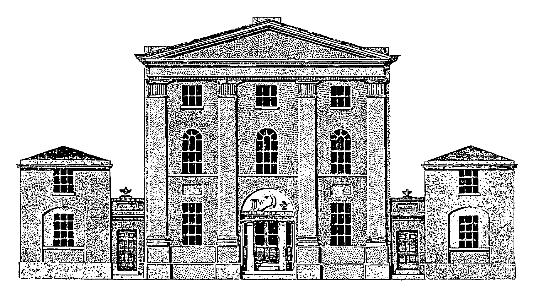
BIRMINGHAM GENERAL DISPENSARY
The Classical Revival gave the town many good smaller buildings in the 1820s and 1830s. They were mostly situated between Ann Street (now Colmore Row) and the upper end of New Street, an area which had remained undeveloped until this period. A striking example was Thomas Rickman's exhibition room for the Society of Artists (1829) with its Corinthian portico projecting over the pavement in New Street. (fn. 22) Almost the only survivor is the same architect's building for the Birmingham Banking Company (now the Midland Bank) erected in 1830 at the junction of Waterloo Street and Bennett's Hill. (fn. 23) The former Curzon Street station, which is still in use as a goods depot, was the last important building in this tradition. It was designed by Philip Hardwick, architect of the Great Arch at Euston, (fn. 24) and opened in 1842. The tall main block, originally containing the booking hall, is fronted by four giant Ionic columns and flanked by archways giving entrance to the station. An impressive industrial building of this period is the former electro-plating works of Messrs. Elkington, built above the Birmingham and Fazeley canal in Newhall Street and since 1951 the Museum of Science and Industry. It is said to have been designed by Josiah Mason (fn. 25) and was intended to be attractive to visitors with its long stucco front, classical porch, fine staircase, and large showrooms.
The first Gothic-Revival building to appear in the streets of central Birmingham, causing a considerable stir, was the rebuilt and enlarged King Edward's School designed in 1833 by Charles Barry (fn. 26) and demolished in 1936. His use of an early16th-century style with its strong vertical emphasis and its rows of pinnacled buttresses foreshadows his work at the Palace of Westminster. Another Gothic structure, obviously influenced by the school building, is Queen's College in Paradise Street, dating from 1843–5 and designed by Drury and Bateman; (fn. 27) it was refronted in 1904.
The latter half of the 19th century, which saw an enormous increase in the public and commercial buildings in central Birmingham, was a period of great diversity in architectural styles. All had some historical basis and many were influenced by continental models. As time went on the tendency was to employ more and more lavish ornament and for the plain stone or stucco facings of earlier years to give way to such materials as moulded brick, terracotta, polished granite and mosaic. The newlyconstructed Corporation Street was much admired in the late 19th century when the buildings in it were said to 'exhibit a pleasing variety of angle, height, and architectural style, in marked contrast to the dull uniformity which prevails in the great thoroughfares of other cities'. (fn. 28) More recently the verdict on Victorian Birmingham has been 'en masse the effect is an architectural jungle'. (fn. 29) Most of the important new buildings in the city were the work of local architects such as Yeoville Thomason, J. H. Chamberlain, J. A. Cossins, and W. H. Ward. (fn. 30) Early in the period a restrained Renaissance style was used for the Birmingham and Midland Institute (fn. 31) by the London architect E. M. Barry. Opened in 1858 this has a Corinthian order to the upper stories and a rounded angle at the junction of Ratcliffe Place and Paradise Street. The Central Lending Library which adjoins it was given a similar façade ten years later. After the great fire of 1879 (fn. 32) the front of the library was restored on the old lines, but the extension in Edmund Street and the highly-original interior of the reference library (fn. 33) (both opened in 1882) were carried out by Martin and Chamberlain. The use of mosaic externally and of locally-made decorative ironwork internally are characteristic of J. H. Chamberlain's work. An addition to the Midland Institute in Paradise Street (J. H. Chamberlain 1881) is of exuberantly Gothic design and in general this style was considered appropriate for buildings with any educational function. Mason's College (J. A. Cossins 1875–80) and the Municipal School of Art (J. H. Chamberlain 1885) are two notable examples. Other prominent Gothic buildings are the Exchange in Stephenson Place (Edward Holmes 1865) and the former Liberal Club (J. A. Cossins 1885) at the junction of Edmund Street and Congreve Street. The Chamberlain Memorial Fountain in Chamberlain Square is also Gothic, as was the canopy, resembling a miniature Albert Memorial, which formerly stood above a statue of George Dawson nearby. They were erected in 1880 and 1881 respectively, both being the work of J. H. Chamberlain. A heavy Renaissance style, becoming more and more ornate and latterly showing the influence of the French Second Empire, was also much favoured, particularly for commercial buildings. The Renaissance style was used at Snow Hill and New Street stations and later for the impressive new buildings along the north side of the widened Colmore Row. The Council House, designed by Yeoville Thomason and started in 1874, provides the most grandiose example. (fn. 34) The upper stories of the main façade have an applied Corinthian order with a much-enriched frieze and cornice. Mosaic figures fill the arch above the central portico and there is symbolic sculpture in the main pediment and in subsidiary segmental pediments near the angles. The front range is crowned by a dome below which internally is a grand vestibule and staircase. A suite of elaborately-fitted reception rooms occupies the principal floor. The City Museum and Art Gallery, built behind the Council House in 1884, continues the main lines of the earlier building on its Congreve Street front, the Corinthian order being repeated at the upper story of the large entrance portico. Adjacent to this, however, the tall clock tower, with its pyramidal tiled roof, shows signs of breaking away from the Classical tradition. The Council House Extension (1912 and 1919), which is connected to the original art gallery by a bridge over Edmund Street, returns to the Renaissance style in one of its 20th-century versions.
After the Council House the next landmark in Birmingham's architectural history was the building of the Victoria Law Courts in Corporation Street. (fn. 35) A competition for designs was won by Aston (later Sir Aston) Webb and E. Ingress Bell, the foundationstone being laid in 1887. The building is in a French domestic style of c. 1500 — roughly corresponding to 'early Tudor' in England — and the external work has been carried out in dark red terracotta. The grouping is informal, the great hall with its flanking octagonal turrets being set back slightly from the street frontage between gabled wings. All possible surfaces are covered with decoration but this is well executed and in keeping with the main design. Much sculpture is introduced including a statue of Queen Victoria by Harry Bates and symbolic figures designed by Walter Crane. Internally the great hall is also richly decorated, having an open hammer-beam roof and stained-glass windows. The building, completed in 1891, was universally admired and many of its features, including the use of ornamental terracotta, became identified with a 'Birmingham' style in architecture. (fn. 36)
Sir Aston Webb was also responsible for the design of the Birmingham University buildings on the Edgbaston site between 1900 and 1909. (fn. 37) His red-brick group was arranged on a geometrical plan and consisted of a semi-circular range with domed blocks radiating behind it and a straight range across the diameter of the semi-circle. These buildings are still incomplete so that it has never been possible to appreciate the scheme as the architect conceived it; on the other hand the limitations of this type of layout for an expanding institution have become only too obvious in later years. The most striking feature of the group is the tall detached clock tower within the semi-circle, built as a memorial to Joseph Chamberlain and modelled on the campanile at Siena. Among additional university buildings erected between the two world wars are the Students' Union (1930), St. Francis Hall (1937), both by H. W. Hobbiss in the Tudor style, and the Barber Institute of Fine Arts (1939), designed by Robert Atkinson and Professor T. Bodkin. A fine equestrian statue of George I from Dublin stands in the forecourt of the Barber Institute. To the north-west of the university site is the Queen Elizabeth Hospital (Lanchester and Lodge, architects) (fn. 38) which, to gether with the University Medical School, formed the largest building scheme in Birmingham during the period between the two World Wars.
At the city centre the monumental effect of the public buildings near the town hall must always have been marred by the fact that they were built piecemeal on comparatively restricted sites. Different ideals of urban layout were current in the 1930s when a new civic centre was planned to the north of Broad Street. (fn. 39) T. Cecil Howitt's neo-Georgian block of municipal offices (now known as Baskerville House), the only part of the scheme to be completed before the Second World War, is set back behind a wide formal garden. The Hall of Memory, standing at one corner of the garden, was erected as a war memorial in 1923–4 to the designs of Cooke and Twist; it is an octagonal domed structure of Portland stone and incorporates bronze statues by Albert Toft representing the armed and women's services. On the opposite side of Broad Street the Birmingham Municipal Bank (T. Cecil Howitt 1933) and the former Masonic Temple (R. Savage), in 1961 being converted into an Engineering and Building Centre, are in the same Classical tradition. Another large building of this period is the Fire Brigade Headquarters (H. Humphries 1935), built of brick with stone dressings in a more domestic Georgian style and occupying an island site of two acres at the north end of Corporation Street.
The greatest changes planned for central Birmingham after the Second World War were in connexion with the new Inner Ring Road scheme, started in 1957. (fn. 40) Apart from housing and schools, most of the new buildings completed by 1961 were commercial in character and many were sited on the course of the new road. They include the long row of shops and offices in Smallbrook Ringway and several tall blocks adjacent to the projected multilevel shopping centre at the Bull Ring. In Holloway Head and Dartmouth Street blocks of flatted factories have been erected to house small industrial firms displaced by redevelopment schemes. (fn. 41) Among other large-scale new buildings are Rackhams' department store in Corporation Street (T. P. Bennet & Son), Five Ways House in Islington Row (Cotton, Ballard & Blow), and the Birmingham Chamber of Commerce building at Edgbaston (J. H. D. Madin). All these are designed in a contemporary mid-20th century style, owing nothing to historical precedent. In many cases they tower above the surrounding buildings and give an entirely new skyline to the city.
Great changes have also taken place on the university site since 1957 where development is proceeding according to an overall plan by Sir Hugh Casson and Nevill Conder. (fn. 42) This provides for an open space north of the original 'diameter' range, with a new library (Verner Rees, Lawrence and Mitchell, 1960) on the axis of Aston Webb's central feature. To the east of the open space is an arts faculty building (1961) by the same architects, while on its west side biology laboratories (Playne and Lacey), a staff house, and a refectory (Casson and Conder) were nearing completion in 1962. Chemistry laboratories (Playne and Lacey, 1961) have been erected to the west of the original semi-circle. Further north a large area beyond Pritchatts Road has been designated as a site for halls of residence.
A statue of Lord Nelson by Sir Richard Westmacott was erected in the Bull Ring in 1809. Other statues in the city include those of Sir Robert Peel by Peter Hollins (1855), now in Calthorpe Park; Joseph Sturge by John Thomas (1862) at Five Ways; James Watt by Alexander Munro (1868) and Joseph Priestley by F. J. Williamson (1874), both in Ratcliffe Place; George Dawson by Thomas Woolner (1881), now in the Birmingham Reference Library; Queen Victoria by Thomas Brock (1901) in Victoria Square. There are also statues of the Prince Consort by J. H. Foley (1868) and of Queen Victoria by Woolner (1887) in the Council House. (fn. 43) In 1956 a bronze group by William Bloye, representing Matthew Boulton, James Watt, and William Murdoch, was erected outside the College of Commerce in Broad Street. (fn. 44)
Domestic Buildings within the 1838 Borough (fn. 45)
Two important moated houses, the manor house and the Parsonage, formed part of the medieval village of Birmingham. Both finally disappeared in the 19th century and little is known of their architectural history. (fn. 46) The oldest secular building to survive in the central area of the modern city is the 'Crown' inn at Deritend. This has been identified with the 'mansion house of timber' seen by Leland when he entered the town in 1538. (fn. 47) The building was thought by Toulmin Smith, who owned the property in the mid-19th century, to date from before 1400. (fn. 48) The character of the structure, however, suggests that it was rebuilt in the early 16th century. The house has two stories and a cellar, the lower part mostly of brick and the upper story, which is jettied on two sides, retaining much of its original close-studded timber-framing. The street frontage has a large gable at each end and a small gabled projection above the central doorway. This projection is supported on curved brackets at first-floor level and internally forms part of the socalled 'gallery chamber' above the hall; its plaster ceiling bears a fleur-de-lys and two star-shaped devices. (fn. 49) Each of the flanking gables has a cambered bressummer carved externally with a design of interlacing arches. (fn. 50) The house was divided into tenements in the late 17th century and owes its preservation to Toulmin Smith who opposed its demolition for street improvement on three separate occasions. (fn. 51) He thoroughly restored the structure in 1862 and added a brick wing facing Heath Mill Lane; this replaced some of the earlier outbuildings which had formed a quadrangle behind the house. (fn. 52)
The 'Golden Lion' inn was another survivor of the timber-framed houses which probably lined the main street of Deritend in the 16th and 17th centuries. It was taken down in 1911 and rebuilt by the corporation in Cannon Hill Park. (fn. 53) It dates from the late 16th or early 17th century and is a three-bayed structure of two stories and attics with modern brickwork below and timber-framing above. The decorative framed panels, containing herringbone and quadrant designs, are typical of the 'blackand-white' houses of the west midlands at this period. Several other examples still existed in the older streets of Birmingham in the late 19th century. (fn. 54) Stratford House, which still stands between Camp Hill and Moseley Road, is a slightly larger house than the 'Golden Lion' but of similar character. It is said to have been built by Abraham Rotton (fn. 55) and carries the date 1601 above the doorway. The ground floor and the back wall have been cased in brick but the three front gables and the two-storied gabled porch retain herringbone and quadrant timbering. The original building consisted of three bays and a cross-passage; a staircase wing was added in the early 19th century. The house, scheduled as an Ancient Monument, is now used as offices, having been restored c. 1955 with the help of a grant from the Historic Buildings Council. (fn. 56)
There is little evidence of later-17th-century building in Birmingham (fn. 57) but it may be assumed that timber finally gave way to brick as the domestic building material at this time. The following century saw an enormous increase in the number of better-class houses, both in the centre of the town and on its northern and eastern outskirts. Many of these Georgian houses were converted to industrial use as the town spread during the next hundred years and most of the remainder have been demolished. (fn. 58) The first important group to go was Old Square, largely destroyed in 1882 for the construction of Corporation Street. The Square, entered by a street in the middle of each side, dated from 1713 and consisted originally of 16 more or less uniform two-storied houses, their five-bayed fronts having angle pilasters, pedimented doorways, and dormer windows. In the last ten years of his life Dr. Johnson was a frequent visitor to No. 1, then occupied by his friend Edmund Hector; panelling from this house is preserved in a room at Aston Hall. (fn. 59) Part of a terrace in Temple Row, probably built soon after St. Philip's church (1711–19), survived until 1957 when it was demolished to make way for a modern store. The terrace consisted of narrow threestoried brick houses with stone doorways, windowheads, string courses, and balustraded parapets. Several originally had business premises behind them. In 1762 they were described as 'lofty, uniform and elegant' and 'inhabited by people of fortune who are great wholesale dealers in the manufactures of this town . . . this is the highest and genteelest part of the town of Birmingham'. (fn. 60) Throughout the 19th century the terrace continued to be occupied by manufacturers and professional men, including a high proportion of doctors. An almost unaltered Georgian house, since 1840 occupied as Dingley's Hotel, stands at the junction of Moor Street and New Meeting Street. It was built in 1745 for his own occupation by Joseph Smith, an iron merchant and a prominent nonconformist. Nos. 18 and 19 New Meeting Street form together a smaller house of the same period. The southern half of Newhall Street, formerly an avenue leading to New Hall itself, was developed after Colmore's private act of 1747. Two houses of 1760–69 on the west side were demolished in 1960, the larger (No. 22) having a three-storied front of five bays with a segmental pediment to the doorway and enriched keystones. At Anderton Square in Whittall Street a threestoried house with a central 'Dutch' gable is set back in a courtyard of smaller dwellings. (fn. 61) This is thought to have been built by Isaac Anderton, a toymaker, c. 1776, the surrounding houses being occupied by his work people; John Wesley is said to have stayed in the square in 1794. A group at the north end of Easy Row is still predominantly Georgian in spite of inserted shop fronts and a 19th-century Gothic building at its centre. The original houses were built between 1769 and 1782 and several retain good doorways with open pediments and fanlights. Nos. 17–19 were designed as a symmetrical unit, the central house being surmounted by a pediment. Round the corner in Great Charles Street three houses have similar doorways while a fourth, No. 7, is larger and somewhat earlier in date.
As with St. Philip's church and Temple Row, so the building of the other 18th-century churches, St. Bartholomew (1749), St. Mary (1774), and St. Paul (1779), was followed by that of dignified houses overlooking their churchyards; in Hutton's words: 'wherever a chapel is erected the houses immediately, as if touched by the wand of magic, spring into existence'. (fn. 62) Near the site of St. Bartholomew's only one mutilated house (No. 1 Jennens Row) survives, while most of St. Mary's Row has been altered as industrial premises. Between May 1780 and March 1781 the houses in St. Paul's Square had increased in number from three to fifty-five. (fn. 63) A hundred years later many had been replaced by warehouses and few were in private occupation. A few still stand, but the domestic character of the square has been completely lost. The fashionable suburb of Ashted, laid out in the last decade of the 18th century round the proprietary chapel which had been Dr. Ash's house, also declined rapidly in status. (fn. 64) As one of the corporation's post-1945 redevelopment areas, most of its remaining buildings have been demolished, but a partly derelict terrace on the south side of Ashted Row still preserves traces of architectural distinction. Its eleven double-fronted houses have three-light windows divided by columns while the doorways are surmounted by enriched friezes and segmental pediments.
Except at Edgbaston, Birmingham is not rich in houses built in the first twenty years of the 19th century — a period which in many towns saw the laying out of terraces, squares, and crescents on a large scale. In 1790 an ambitious scheme had been begun between Cambridge Street and the canal which was to have consisted of a crescent of 23 stone-fronted houses, designed by John Rawsthorne and built by Charles Norton. (fn. 65) Three years later only the flanking wings had been completed and the project was said to have failed because of the depression caused by the French wars. The five houses which remain, representing the east wing, have been converted into the Crescent Theatre, their rather plain stone facades having been preserved intact. In the 19th century this area rapidly became unsuitable for residential development owing to the concentration of industry along the canal. A half-derelict survival of its earlier phase is in Kingston Row, a street formerly crossing the canal, (fn. 66) where the stucco fronts of five terraced houses incorporate small-paned shop windows. Further south St. Peter's Place and St. Martin's Place, the latter a long terrace of late-18th-century brick cottages with small front gardens, form together a quiet backwater with almost a village atmosphere. (fn. 67)
Bennett's Hill and Waterloo Street, constructed across land which had remained open until after 1820, (fn. 68) contain some good stucco frontages of the Greek Revival period, notable examples being Nos. 35–37 Waterloo Street and No. 5 Bennett's Hill. It was laid down that all new houses on the south side of Ann Street were to have stone or cemented fronts (fn. 69) — an indication that, at this period, unfaced brickwork was considered suitable only for cheaper dwellings and industrial buildings.
The special character of Edgbaston as a residential suburb has already been described. (fn. 70) Its development started in the early 19th century when the 'villa', as opposed to the terrace house, was becoming the ideal for the wealthier town-dweller. A spacious lay-out with large garden plots was envisaged from the beginning and many of the bigger houses are virtually country mansions standing in their own grounds. Along the main thoroughfares, such as Hagley Road, Calthorpe Road, and Bristol Road, the arrangement is one of single houses and pairs, rather than of continuous terraces, and many of the frontages have great architectural distinction. On the north side of Hagley Road, immediately west of Five Ways, a row of three-storied terrace houses was already in existence by 1810; (fn. 71) several of these are still comparatively unaltered. The present Grosvenor Hotel which adjoins them has an ambitious stucco front in the Classical Revival taste of c. 1815. Further west are a number of notable early-19th-century houses, both of brick and stucco, all in the Classical style. Among them a stuccofronted terrace of six three-storied houses (Nos. 97– 107) has its upper stories divided into panels by engraved pilasters and its doorways and lower windows set in arched recesses. On the south side of Hagley Road at its west end are several large detached brick houses dating from soon after 1800, three of which are now part of Edgbaston High School. Many plots on this side have been cleared for the erection of mid-20th-century blocks of flats and offices. Nevertheless as one proceeds westwards along Hagley Road all the phases of 19th-century architectural taste can still be recognized, from the Classical examples mentioned above, through the 'Tudor' and 'Italianate' styles of the forties and fifties, to the full-blown Gothic Revival of thirty years later. In the Ladywood district north of Hagley Road the early suburban pattern has been almost obliterated by later working-class development and by the disappearance of the large houses in their own grounds which formerly stood there. (fn. 72) One survival, however, giving its name to Monument Road, is the former 'Perrot's Folly', a sevenstoried octagonal brick tower with Gothic windows and an embattled parapet; internally it contains rococo plaster-work. It was built in 1758 as a lookout tower by John Perrot and is now scheduled as an Ancient Monument. (fn. 73) Since the late 19th century the tower has been used as a meteorological observatory by the Birmingham and Midland Institute and in 1958 a successful appeal was launched for its repair. (fn. 74)
After 1838 the history of building within the new borough ceases to be concerned with the houses of Birmingham's well-to-do inhabitants who were moving well outside its boundaries. The central district was progressively occupied by public and commercial buildings (see above), while any undeveloped land immediately adjoining the built-up area was taken over for industry and for the housing of industrial workers. (fn. 75)
Buildings in the Areas added since 1838
Aston Hall, the most important secular historic building in Birmingham, lies in that part of ASTON ancient parish which remained outside the borough in 1838. (fn. 76) As the former manor house of Aston its description will be found elsewhere. (fn. 77) At Erdington, originally part of Aston parish, the oldest building is the 'Green Man' inn, a medieval timber-framed structure east of Bromford Lane. (fn. 78) It contains a much altered open hall of two bays, divided by a cruck truss and having a second pair of crucks in its south wall. At the north end of the hall is a two-storied cross wing, probably of early-16thcentury date, with much of its original timber in position. The building was altered in 1916 and a timber-framed stable block to the south-west was replaced by a new brick wing after the Second World War. (fn. 79) Along the main road at the southern end of Gravelly Hill there are early- and mid-19thcentury middle-class houses, arranged singly or in pairs, of the type found in all the outlying areas of Birmingham which were developing at this period. Further north many late Victorian villas are set in large gardens. St. Mary's College, lying just inside the city boundary at New Oscott, was built between 1835 and 1838, Joseph Potter of Lichfield being both architect and builder. (fn. 80) After 1837 A. W. N. Pugin was employed to design the interior fittings and in 1860 additions were made by E. W. Pugin. The building is of red brick with stone dressings in the Tudor style, the principal feature of the entrance front being a central tower with oriel windows to the upper stories. Other notable 19th-century buildings at Erdington are Erdington Abbey (1879–98) (fn. 81) and Sir Josiah Mason's Orphanage (1868 with additions of 1874). The latter, a large block of red brick buildings with central and western towers, was designed by J. R. Botham in a Romanesque style; Josiah Mason (d. 1881) is buried in the chapel. (fn. 82) At the Lyndhurst estate a group of stucco-faced detached houses, standing in large gardens and dating from c. 1840, was demolished in the late 1950s. The 38 a. site has been used for a 'mixed-development' housing scheme, incorporating several tower blocks of flats as well as lower buildings; in 1961 the estate won a Civic Trust amenity award. (fn. 83)
At SHELDON a number of old farmhouses, which included Outmoor Farm and Mackadown Farm, (fn. 84) have been taken down since the Second World War to make way for new housing. In 1960 Moat Farm in Church Road was demolished and the moat surrounding it was filled in. A partly timber-framed house about 100 yards to the southwest, used for a time as the presbytery for the new church of St. Thomas More, was demolished in 1962.
Most of the older buildings in the three former Worcestershire parishes of Yardley, King's Norton, and Northfield have been described in an earlier volume (1913). (fn. 85) At YARDLEY, Hall Green Hall was demolished in 1936, (fn. 86) Fox Hollies Hall between 1933 and 1937, (fn. 87) and Lea Hall in 1937. (fn. 88) Blakesley Hall was thoroughly restored by the corporation in 1935 and opened as a branch museum devoted to local history and archaeology; early fire engines are housed in its 18th-century barn. (fn. 89) Hay Hall was acquired in 1917 by Reynolds Tube Company Ltd. and is still standing as part of their factory premises in Redfern Road, Tyseley. The central part of the house has an arch-braced collar-beam roof truss and may well represent an open hall of the 14th or 15th century. Timber-framing is exposed externally on its south-east wall which has at one end a twostoried timbered porch containing a pointed arch. A solar wing to the north-east has stone-mullioned windows and was either encased in diaper-patterned brickwork or newly built in the 16th century. It is of three bays divided by open roof trusses which were later enclosed in a dormered attic. Tudor wallpainting and a fragment of stained glass have survived. The house was damaged by fire in 1810 and it was probably soon afterwards that the fivegabled south-west front was rebuilt. The building was restored and altered in 1948. (fn. 90)
At KING'S NORTON, Hawkesley Hall, a mid19th-century house on a moated site, is now used as a farm. In 1958 the site of Hawkesley Farm, about 1½ mile to the west, was incorporated in a new housing scheme which won a Civic Trust amenity award in 1961. (fn. 91) Part of the moat has been preserved and now encloses one of the estate's three tower blocks of flats, as well as several old people's bungalows set round a green. Bell's Farm to the east of Walker's Heath is a largely 17th-century house approached through a gateway with sandstone piers and ball finials. The front, which is of brick and has twin gables, a central doorway, and altered windows, is flanked by tall chimneys with fluted stacks, one of which bears a date tablet of 1661. The walls are now roughcast, but exposed moulded bressummers to the side and rear gables suggest that the back of the house is timber-framed and of 16th- or early-17th-century date. Part of a moat survives in the farmyard. Highbury Hall, built by Joseph Chamberlain for his own occupation in 1879– 80, was named after Highbury in London where his early years were spent. The house was designed by J. H. Chamberlain and is a brick mansion with stone dressings, having many gabled wings and Gothic bay windows. The gardens, parts of which are now a public park, were elaborately laid out and included orchid houses. After Chamberlain's death in 1914 the house became a hospital and was extended in 1922. In 1932 the property was given to the corporation. Chamberlain's study and breakfast room were opened as a memorial museum in 1934, the remainder of the house being used as a home for aged women. (fn. 92)
NORTHFIELD retains more village character in the area immediately surrounding the churchyard than any of the other parishes which have been absorbed into Greater Birmingham. The buildings are not of great individual interest but include a group of cottages dated 1750 and the Great Stone Inn, a whitewashed brick house of about the same date. Behind the cottages a row of early- or mid19th-century nailers' houses still has small detached nail-shops at the rear. Immediately north of the inn the sandstone walls of the old village pound, probably dating from the 17th century, have been restored and the space within has been turfed over. The 'great stone', which formerly stood against the angle of the inn itself and is one of a number of glacial boulders found in this district, (fn. 93) has been placed inside the pound. Groups of 18th- and early19th-century brick cottages survive in Church Hill, Church Road, Bristol Road, and Bell Lane. The site of Weoley Castle (fn. 94) was partly excavated before the Second World War and plans were made showing a 13th-century guest house, chapel, great hall, kitchen, and dairy. In 1955 the site came under the control of the Archaeological Department of Birmingham City Museum. During excavations undertaken in 1960–61 the remains of a timber hall, probably of late 12th-century date, were discovered below the level of the 13th-century manor house. (fn. 95) Castle Farm, Wychall Farm, and Middleton Hall Farm have all been demolished.
Bournville village began to develop immediately west of Cadbury's factory in 1895. (fn. 96) Many of the architectural features of the earliest houses, mostly arranged in pairs along tree-lined roads, can be recognized in suburbs built all over the country in the following 40 years. The village grew up at a time when many architects were showing an increasing interest in traditional domestic building and were turning away from the various imported late 19th-century styles, with their often meaningless applied decoration. This tendency is reflected in Bournville's public buildings which are grouped round a triangular green. They include the primary school (1905), a separate school for infants (1910), the Friends' Meeting House (1905), and Ruskin Hall (1905 with a later addition). All were designed by W. A. Harvey and are built of soft red brick in a domestic Tudor style, having stone dressings, gables, and steeply-pitched tiled roofs. The square tower which forms part of the school building is surmounted by a cupola containing a carillon of 48 bells, erected in 1934 to replace a smaller belfry. A row of shops with half-timbered upper stories had been built near the green by 1904. The octagonal 'rest-house' in the centre of the green, modelled on the early-17th-century yarn market at Dunster (Som.), dates from 1914. Two ancient timberframed houses, Selly Manor and Minworth Greaves, have been reconstructed on a corner site to the north-east. (fn. 97) The manor house at Selly, which stood a mile away, was in existence in the early 14th century but may well have been rebuilt after 1400; it had been divided into three cottages before 1896 (fn. 98) and was acquired by George Cadbury in 1907. The west wing, thought to be the oldest part of the present building, has close-studded wall-framing, a jettied gable end and an outside staircase. Minworth Greaves house came from outside the north-east boundary of the city in 1911 and was re-erected c. 1930. It incorporates a two-bayed hall of medieval cruck construction, the third bay and the gallery being modern additions.
HARBORNE has no definite nucleus of old buildings and few which date from before the 19th century. Along High Street and Vivian Road there are several rows of late-18th- and early-19thcentury cottages, some brick and some stucco-faced. Harborne Terrace, probably built c. 1800, was originally occupied by nail-makers and within living memory a detached nail-shop stood behind each house. (fn. 99) The earliest residential streets, such as High Street, Greenfield Road, and the streets between them, contain small middle-class houses of no particular architectural distinction. Greenfield House is a larger and probably older house which was occupied by David Cox between 1841 and 1859. (fn. 100) It appears to have been faced with stucco, enlarged and given some of its 'picturesque' features at this period. The more important country houses, built by wealthy Birmingham men in the late 18th and early 19th centuries, lay to the south of the village. Harborne House, now Bishop's Croft, is described elsewhere. (fn. 101) Metchley Abbey, where E. A. Freeman was born in 1823, is a rambling house built in the Gothic taste of c. 1800 with mid-19thcentury additions in the same style; it was divided into two dwellings about 100 years ago. (fn. 102)
At HANDSWORTH the only ancient secular building is the so-called 'old town hall', a timberframed structure thought to date from the 15th or early 16th century. (fn. 103) It is of three bays, having gable-end and intermediate cruck trusses, making four pairs of crucks in all. A chimney at the east end and some former brick infilling may have dated from 1625 and it is probable that at least parts of the upper floor were inserted at the same time. In 1946 (fn. 104) the building, used as three tenements at least since the early 19th century, was reconstructed to form two dwellings with tiled roofs, dormer windows, and new brick infilling between the timbers.
Soho House, the home of Matthew Boulton from about 1766 until his death in 1809, still stands in what is now Soho Avenue. When Boulton acquired the lease of his property on Handsworth Heath in 1761 it included an uncompleted house which he made habitable and later enlarged. (fn. 105) His alterations were spread over a long period and the building probably did not assume its final form until 1799. Ten years earlier, however, he was employing Samuel Wyatt as architect and the foundations of new reception rooms were being laid. Among other fittings Wyatt sent a water closet from London at a cost of £11 2s. 3d. At some period heating plants were installed, ducts through the house being supplied with warm air from stoves in the cellars. In 1796 James Wyatt, Samuel's more famous brother, submitted plans and elevations which apparently provided for a third story to part of the existing house and for extensions to a south-west wing; there was also a proposal to enlarge the stables. Supervision of the work was evidently inadequate and by 1798 Samuel was again in charge, probably completing the scheme to his brother's designs. There is no evidence that Robert Adam was ever employed here. (fn. 106) In 1861 the house was taken over as a vicarage for the new church of St. Michael and most of the south-west wing and several outbuildings were demolished. While the house was occupied as a hotel in the 20th century a first-floor addition to what remained of the wing was built. In 1956 the property was acquired by the General Electric Company for use as a hostel for student apprentices. The present house, apart from its modern addition, represents the original mid18th-century building as enlarged and remodelled by the Wyatts. The principal entrance front of three stories and seven bays is faced with slate, giving the appearance of finely-jointed ashlar masonry. It is divided by four tall Ionic pilasters supporting an entablature with a boldly projecting cornice. The central three-light windows, the upper one semicircular, are set in an arched recess; below them the semi-circular Ionic porch, which had been taken down, was reconstructed in its original form in 1957. This elevation, including its top story, was almost certainly the work of James Wyatt. Internally the comparatively small rooms and the unimpressive staircase may be legacies from the original house or from Boulton's first modest additions. The principal rooms, however, are elegantly fitted, the central bay-windowed parlour having a bowed end, niches, and a groined ceiling supported on Ionic columns. Three pairs of fine mahogany doors in the hall were supplied by Samuel Wyatt in 1799. The Soho Manufactory, standing on low ground beside the Hockley Brook about 100 yards from the house, was demolished in 1862–3. (fn. 107) It is said to have been begun in 1764 but it was some years before it could be completed and extensions were made at various times. In size and general impressiveness the buildings were something quite new in industrial architecture. The front range of the main quadrangle was of three stories with a four-storied tower-like feature in the centre, surmounted by a cupola. This front elevation was flanked by the pedimented gable-ends of the side wings. The upper stories of the side wings were said to have contained workmen's dwellings. (fn. 108) The Soho estate was broken up for building in the 1860s and the only survivals of the firm's activities are at Soho Foundry just outside the city boundary in Smethwick. Here some original foundry buildings, workmen's cottages, and an early gas holder are incorporated in the works of W. & T. Avery Ltd. Heathfield Hall, built for his own occupation by James Watt in 1790 and demolished in 1927, lay within the triangle bounded by Hamstead Road, Church Hill Road, and Heathfield Road. It was a two-storied stucco house with a low-pitched roof and a trellis verandah between two projecting wings. (fn. 109) Sycamore House, the home of William Murdoch, was a smaller square building with a Doric porch and flanking single-storied wings. It stood to the west of Queens Head Road and was also demolished in 1927.
During the brief life of Handsworth as a superior residential suburb (fn. 110) several of the principal roads were built up with moderate-sized houses, arranged singly, in pairs, or in short terraces. Many of those dating from the first half of the 19th century are of attractive design but all have now declined in social status or have been converted to commercial use. Near the parish church there are one or two gabled cottage-style residences dating from the 1840s, while Handsworth Wood, which survived longest as a high-class suburb, contains much ornate lateVictorian domestic architecture. Two notable individual buildings at Handsworth are St. Mary's Convent in Hunters Road (A. W. N. Pugin, 1841– 7) (fn. 111) and the Wesleyan Theological College (1880) built of brick with stone dressings and designed by Ball and Goddard in an early Tudor style. (fn. 112) At Old Oscott, in the Perry Barr division of the ancient parish, the buildings at the Convent of Mercy, Maryvale, have a nucleus which dates from before 1794 when the original Oscott College was opened there. (fn. 113) Additions made before 1820 are mostly of very plain red brick externally but include a stone colonnade and an exhibition room built in 1816. The old chapel of 1778 is in the Classical style but there is also a Gothic chapel at a higher level which dates from 1820. (fn. 114) Perry Bridge, known locally as the 'zig-zag' bridge because of the line of its parapets, is a stone structure of six irregular arches, having cutwaters to the piers and refuges at road level. It was rebuilt or extensively repaired about 1709 and in 1932 a new concrete bridge was built beside it. The old bridge is scheduled as an Ancient Monument and was underpinned in 1956. (fn. 115)
Workers' Housing in Birmingham (fn. 116)
By the early 19th century most of the less wellpaid workers in central Birmingham were living in courts, more or less cramped according to the space available for building in an already largely developed area. The dwellings often backed on to industrial buildings or on to one another. An early example of such a court, probably more generously planned than many others, is Anderton Square, dating from c. 1776. (fn. 117) The court is approached from Whittall Street by a covered passage through a front range of buildings which include at least two 'back-to-back' workers' houses, one entered from the passage and the other from the court. Similar houses, backing on to adjacent buildings, form the two sides of the court, while the master's house occupies the further end, opposite the entry. There were formerly privies in the north-west corner of the court and a well near its centre. Each house consisted of a coal cellar and three rooms, one above the other, the entrance door opening straight into the ground floor room and the staircase leading off it. The condition of some of these older courts was already causing concern at the time of the sanitary report to the General Board of Health in 1849. (fn. 118) Many were described as 'closely-built, narrow and ill-ventilated'; their surfaces were bad and there was 'want of good privy accommodation, in some none at all'. Even some of the newer houses at this period, particularly near the River Rea, were shoddily built and soon in need of repair. In general, however, each family was said to occupy a separate house and there was 'no congregation of families in flats and cellars'. (fn. 119) Many of the insanitary courts were swept away by the redevelopment at the town centre in the middle and at the end of the 19th century, notably by clearance for the railway stations and after the Artisans' Dwellings' Act of 1875. (fn. 120)
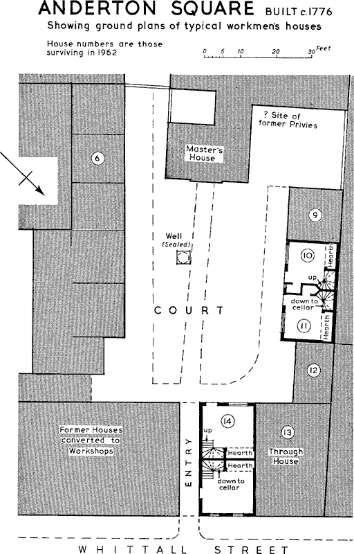
ANDERTON SQUARE
Built c. 1776 Showing ground plans of typical workmen's houses
Mid-19th-Century Back-To-Back Houses
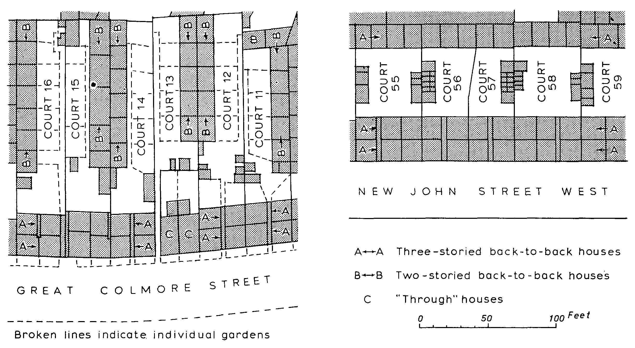
The courtyard system, on a slightly more generous scale, was perpetuated in the many new areas which were built up after 1830. The usual layout consisted of a row of houses facing the street and backing on to it a second row opening on to a series of courts. Often the front terrace was of three stories while two-storied rows formed the back or sides of the courts. These backed in their turn on other rows which opened on to adjacent courts. The only access to the courts, which contained communal privies, ash pits, and wash-houses, was by narrow covered passages through the double terrace facing the street. The internal arrangement of the three-storied houses varied slightly in detail but was essentially the same as at Anderton Square. Each had a coal cellar and three rooms, one above the other, with a narrow and often unlighted space partitioned off for the staircase; in the two-storied houses the upper floor was divided into two small bedrooms. This general layout seems to have persisted almost unchanged until the late 19th century. (fn. 121) In 1849 the newer courts had been considered 'excellent in their arrangement': their surfaces were 'carefully laid with blue brick' or divided into small gardens. Criticism was mainly of inadequate sanitary arrangements and the fact that the ash pits and privy middens were combined. (fn. 122) By the time of the report of the Special Housing Inquiry in 1914, when there were still over 43,000 back-to-back houses in Birmingham, the corporation had powers to enforce certain improvements and repairs: in general privy middens had been replaced by pan closets and later by water closets, (fn. 123) while in some cases cellars had been filled in and sinks installed in the houses. Once more the main objection to these houses was 'the degrading and disgusting condition of their outbuildings . . . the closet question is really at the root of the proper housing of the working classes'. Owing to a growing shortage of houses with low rents, however, it was realized that back-to-back dwellings would continue in use for many years. (fn. 124) Between the two World Wars, when the shortage was even more acute, only a limited amount of slum clearance was possible in spite of the corporation's vast new housing schemes on the city outskirts. At this period valuable pioneer work was done by the Copec House Improvement Society, founded in 1925. By the acquisition and alteration of a few properties in the worst areas it was shown how sanitary accommodation could be increased, light and air introduced into the courts by the demolition of 'front' houses, and, in some cases, how front and back houses could be combined to form one 'through' house. (fn. 125) After the Second World War the acquisition by the corporation of five central areas for redevelopment heralded a more wholesale attack on the problem. By 1960 demolition was proceeding rapidly although there were said to be still 25,000 back-to-back houses in the city. (fn. 126)
Late-19th-Century Tunnel-Back Houses
The model by-laws adopted by the borough in 1876 laid down that every dwelling should have a minimum air space on at least two sides, thus putting an end to the building of back-to-back houses in Birmingham. (fn. 127) The density of new housing was thereby much reduced. A more open courtyard layout with small front gardens but often with communal closets and wash-houses seems to have persisted for some years (fn. 128) and many houses at this period were built in short terraces at rightangles to the street.
The two-storied terraced cottages with four rooms and individual back yards which were built in such numbers in some expanding towns in the 19th century (fn. 129) never seem to have been provided for the lower-paid workers in central Birmingham. Probably the value of land was always too high to make this profitable. Where such cottages existed they were originally intended for those who could afford slightly higher rents. Several examples surviving from the first half of the 19th century, although now (1961) in poor repair, show distinct architectural character. In New John Street West and Guest Street, for example, some quite elegant terraces are stucco-fronted and have Classical or Gothic doorways. Plans of a terrace in Bridge Street West were given in the sanitary report of 1849; here the layout was commended but the juxtaposition of water supply and cesspools was criticized. These houses, which still stand, have two rooms to each floor and individual back yards containing washhouses and closets; externally there are 'Tudor' hood-moulds above the windows and decorative eaves fascias. Such cottages were originally let at 5s. a week while the rents of the newer back-to-backs were from 2s. 6d. to 3s. 6d. (fn. 130) Still better terraced houses, mostly along the main roads, are found in all the areas which developed at this period, showing that there was demand for accommodation by a wide range of income groups. Later these superior houses were often converted into retail shops or small industrial premises.
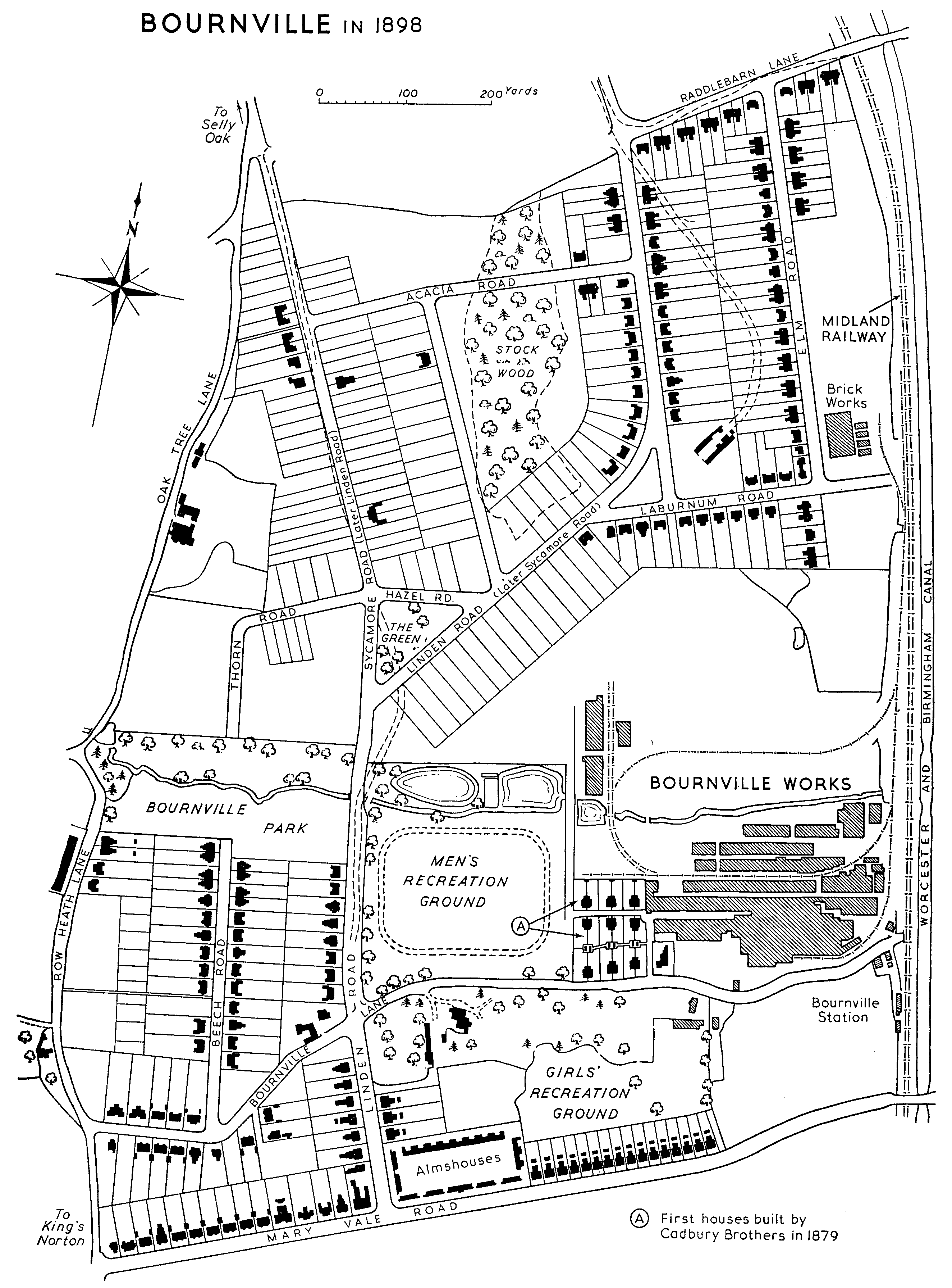
BOURNVILLE in 1898
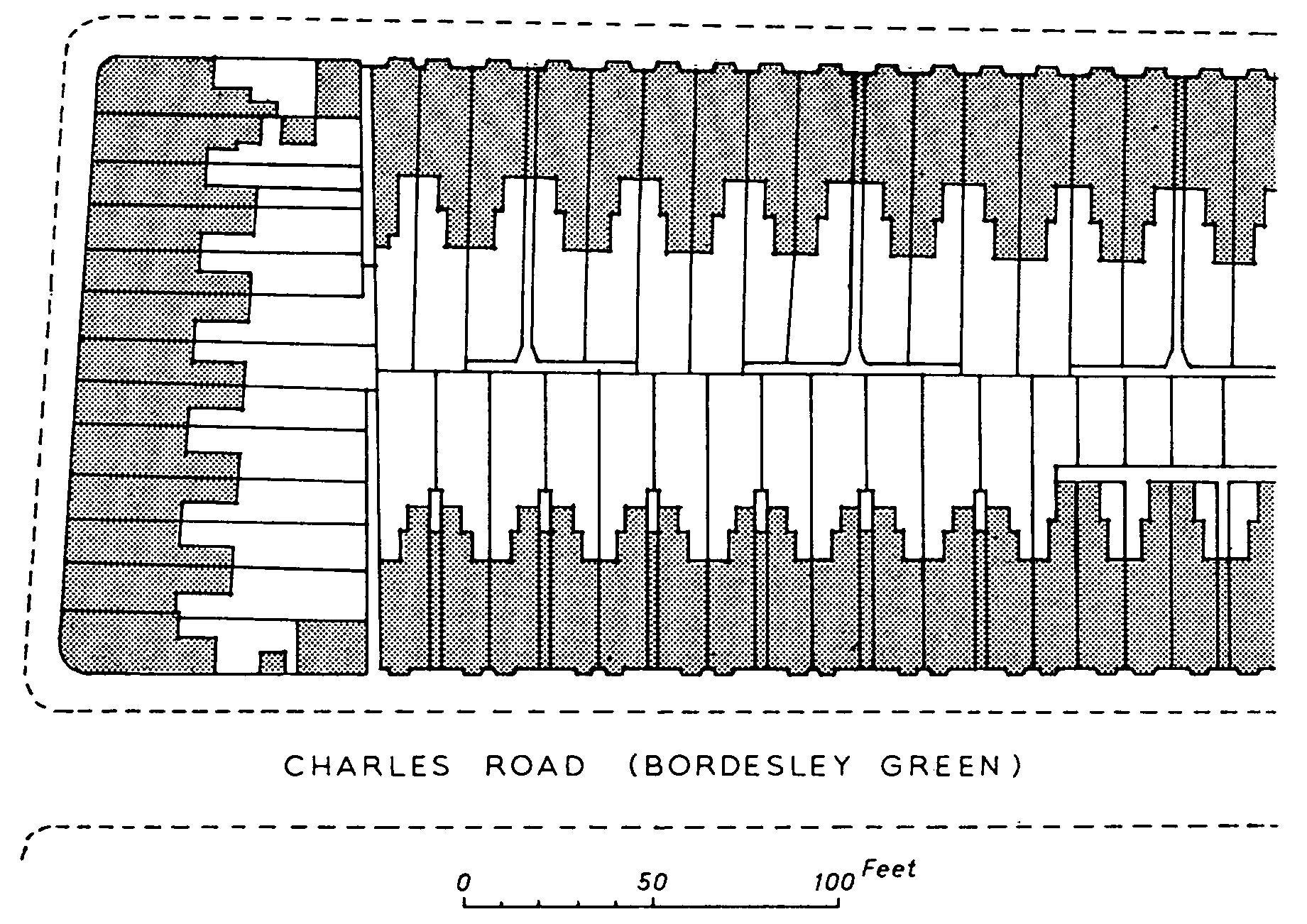
The so-called 'tunnel-back' house was a late-19thcentury version of the terraced cottage which developed because of the generally improved standards and the adoption of building by-laws. It consisted of a front and back room on each floor with a wash-house or scullery, generally having a third bedroom above it, housed in a projecting wing at the rear. Behind this again were a coal store and water closet. The advantage to the developer of this long narrow plan was the small frontage occupied by each house, enabling a maximum number to be built on any given site with a minimum of roadmaking. It was well adapted to continuous terraced housing where back access could be provided at intervals by entries from the street, but it could also be used for semi-detached pairs. The tunnel-back was, in fact, the basic plan for small urban dwellings all over the country in the late 19th and early 20th centuries. In the outlying areas of Birmingham, now often known as the 'middle ring', many hundreds of streets were laid out with terraces of this type. The tendency was for the better-paid workers to move out to them, leaving the poorer tenants to occupy the older houses near the city centre. (fn. 131)
Until the First World War almost all the workingclass housing in Birmingham was built for profit by private developers. The only schemes carried out by the corporation were those in Ryder Street (1889–90), Lawrence Street (1891), and Milk Street (1898). (fn. 132) The Ryder Street scheme consisted of 22 four-roomed cottages with indoor closets but communal back yards. In Lawrence Street there are 82 similar cottages arranged in a series of terraces at right-angles to the street, again with communal courts between the rows. All the terraces have the arms of the city at their gable ends. The Milk Street scheme was an experiment in tenement housing which was not very successful. The three-roomed flats are in blocks of two stories, the upper flats having balcony access and ducts to convey refuse to incinerators in the yards below.
Among building-society projects of about this period (fn. 133) a notable example was the estate at Harborne developed about 1908 by Harborne Tenants Ltd. under the chairmanship of J. S. Nettlefold. This consisted of about 500 houses and was laid out on garden-city lines at fewer than ten houses to the acre. (fn. 134) Nevertheless the planning and financial direction were so competent that the self-contained cottages could be let for as little as 5s. a week. (fn. 135) By far the most important scheme of this kind, however, was that at Bournville, initiated by George Cadbury. (fn. 136) When the Cadbury firm moved from the town centre in 1879 several semi-detached houses were built for key workers. These were on the tunnel-back plan and stood in large gardens. In 1895, and more particularly after the Bournville Village Trust was founded in 1900, the estate was much extended; it was never intended exclusively for employees of the Cadbury firm, nor were the dwellings of uniform size. Various experiments were tried, both in the financing of different schemes and in the design and layout of the houses. Bournville became nationally and internationally famous, many of its features influencing the garden-city movement of the early 20th century. As the aim was to produce a village setting, so the grouping of the houses was open and informal. Architecturally the ideal was to avoid monotony and to concentrate on rural rather than urban styles. Even before 1900 the accepted tunnel-back plan was giving way at Bournville to an improved 'cottage' plan, made possible by the provision of wider frontages. In this the scullery and third bedroom were included in the main block and a projecting rear wing was eliminated; thus well-lighted back rooms could be provided overlooking the garden. This basic plan, particularly as applied to small semi-detached houses, became the standard one for local-authority housing all over the country after the First World War.
With the granting of housing subsidies on a national basis after 1918 the responsibility of providing small rented dwellings passed almost entirely to local authorities. Even before the war such building had ceased to be profitable for private developers in Birmingham and had come almost to a standstill. (fn. 137) Between the two World Wars over 46,000 municipal houses were built, mostly at a density of twelve to the acre and arranged in pairs or short terraces. (fn. 138) The majority were of the threebedroomed type, having bathrooms either upstairs or down. Vast new suburbs were created of which Kingstanding was the largest and Weoley Castle at Selly Oak one of the most ambitiously planned. Characteristic features of this layout were numerous culs-de-sac, curving roads, and the provision of central community buildings. The only municipal flats built in the early part of this period were in Garrison Lane, Bordesley, begun in 1925; these were in three-storied blocks with mansard roofs and Georgian sash windows, the individual flats being approached by communal halls and staircases. After the Housing Act of 1930, however, it became increasingly necessary to provide higher-density housing for families displaced by slum clearance. At first this was in the form of two-storied blocks of flats, each flat having separate external access. (fn. 139) At the Ashcroft Estate, Great Brook Street, the Birmingham tradition was carried on by arranging the blocks round large courtyards, the central spaces being of asphalt and the perimeters divided into small gardens. As time went on more tenement dwellings were provided, several large-scale schemes, such as that at Emily Street, showing the influence of contemporary east-European housing. (fn. 140) Nevertheless by 1939 flats constituted only about 4 per cent. of all the new dwellings built by the corporation. (fn. 141)
Immediately after the Second World War the policy in Birmingham was to meet the acute housing shortage by erecting temporary pre-fabricated bungalows, followed by permanent buildings, preferably in the form of small houses. (fn. 142) It soon became evident, however, that the size of the problem and the dwindling amount of available building land would necessitate higher-density housing. By 1957 it was the declared policy of the recently-formed city architect's department to provide in the central area one-third of all dwellings in tall blocks of flats, another third in multi-storied maisonettes, and the remainder in individual houses. Over 100 blocks of up to twelve stories in height had already been completed within the city boundaries by 1957 and many more were planned or under construction. (fn. 143) On selected suburban sites widelyspaced tower blocks rising to sixteen stories are now (1961) a striking new feature of the Birmingham landscape. Both in the five central redevelopment areas and in the suburbs the aim has been to plan comparatively large districts as a whole, providing within them not only shops, schools, and other community buildings but also dwellings for those with widely different incomes and housing needs. This policy of 'mixed development' has led to great variety in the size and planning of individual dwellings. In addition to houses and flats, each area has its quota of old people's bungalows and there has been increasing use of two-storied family maisonettes, built one above the other in blocks of four or six stories. (fn. 144)