A History of the County of Gloucester: Volume 5, Bledisloe Hundred, St. Briavels Hundred, the Forest of Dean. Originally published by Victoria County History, London, 1996.
This free content was digitised by double rekeying. All rights reserved.
'Lydney', in A History of the County of Gloucester: Volume 5, Bledisloe Hundred, St. Briavels Hundred, the Forest of Dean, (London, 1996) pp. 46-84. British History Online https://www.british-history.ac.uk/vch/glos/vol5/pp46-84 [accessed 11 April 2024]
In this section
LYDNEY
The large parish of Lydney (fn. 1) lay 21 km. southwest of Gloucester on the west bank of the river Severn. It contained the small town of Lydney with an adjoining village called Newerne, the village of Aylburton, and scattered farmsteads in the tithings of Purton, Nass, and Allaston. Aylburton developed separate institutions of parish government and assumed the status of a civil parish in the late 19th century, while remaining a chapelry of Lydney.
Although Lydney had a market from 1268 and some inhabitants later held by burgage tenure, the town remained small and insignificant for much of its history. The parish was dominated by its landowners, particularly after the late 16th century when most of the land was formed into a large estate by the Winters, who were succeeded in possession by the Bathursts in 1723. The estate was unusually rich in non-agricultural resources, including fisheries, mineral deposits, and extensive woodland, and its owners also profited from the establishment of ironworks at the start of the 17th century and the reclamation of saltmarsh in the early 18th. In the early 19th century the building of a tramroad and harbour to serve the coal trade of the Forest of Dean began to transform Lydney's economy, which later benefited from the growth of the ironworks into a tinplate factory and from railway building. In the mid 20th century the town's success in attracting new industry made it one of the main centres of employment for the Forest region, and by 1990 it had been much enlarged by suburbs.
The ancient parish covered 7,077 a. (2,864 ha.), with Aylburton later forming a separate parish of 1,883 a. (762 ha.). (fn. 2) In 1935 29 a. (12 ha.), near New Mills in the angle formed by the Newerne stream and a tributary brook, were added to Lydney from West Dean. (fn. 3) The whole parish lay within the jurisdiction of the Forest of Dean by 1228, but it was disafforested in the early 14th century. (fn. 4) As a result, a number of its woods were termed purlieus in the 16th century, (fn. 5) a name retained by one large wood, the later Purlieu common in Purton. Former parts of the royal demesne woodland adjoining the parish, the Snead (later called Maple Hill) and Kidnalls, covering c. 280 a. on the east side of the valley of the Newerne stream, are included in this account. The two woods were granted on lease by the Crown in 1626, (fn. 6) and the reversion was included in a grant of the bulk of the royal Forest land to Sir John Winter in 1640. (fn. 7) He retained it when he surrendered his other rights under the grant in 1662, (fn. 8) and the Snead and Kidnalls descended as part of his Lydney estate and were regarded as outside the Forest bounds. They remained extraparochial until 1842 when they were included in the new township of West Dean. (fn. 9)
The long north boundary, between the ancient Lydney parish and what were formerly parts of Newland and the extraparochial Forest, follows an irregular course across the hillsides. At its west end above Alvington parish it includes the former Prior's Mesne estate, which was assarted from the royal demesne of the Forest in 1306 by Llanthony priory. (fn. 10) The priory owned both Aylburton and Alvington manors, which left the boundary between them a matter of dispute after the Dissolution. Prior's Mesne was claimed by the lords of both manors in the 1580s (fn. 11) and was later secured by the lord of Aylburton. About 1710 the owners of the two manors were disputing common land lying south of Prior's Mesne (at the later Glebe farm) and it was claimed on the part of the owner of Aylburton that the boundary at that point was Woodwards brook running west and south of the disputed land; (fn. 12) in that dispute the owner of Alvington evidently established his claim, for the land was later part of Alvington common, with the parish boundary north and east of it, joining the brook at the south side of Ferneyley wood. (fn. 13) A feature described as the Forest ditch or the great old ditch defined the boundary between Prior's Mesne and the land in Alvington common c. 1710. It was no longer discernible in 1990 but on part of the boundary, south of the house called Aylburton Lodge, there was a drystone wall of massive dimensions, apparently part of a longer wall built following the dispute. (fn. 14)
The south-west boundary descends Woodwards brook into the riverside meadows but close to the river makes a sharp south- westerly turn along a drainage dyke to the inlet called Cone Pill, including the whole river frontage of Alvington and part of that of Woolaston. (fn. 15) That illogical boundary, evidently in part the result of land being gained from the river, (fn. 16) was presumably not established until after 1277 when Llanthony priory became owner of Aylburton as well as Alvington; it was perhaps still not settled in 1318 when the priory and Tintern abbey (Mon.), owner of Woolaston, were disputing part of the Stirts, the tract of land on the river side of the boundary. (fn. 17) By 1602 the Stirts was accepted as being part of Aylburton but, having formed part of Llanthony's demesne, it was claimed not to be tithable to Lydney church. (fn. 18) The north-east boundary of Lydney parish descends a brook, called Lanes brook by 1300, (fn. 19) to reach the Severn at Purton Pill, and the river forms the long south-east boundary.
The boundary between the civil parish (formerly chapelry or tithing) of Aylburton and the rest of the ancient parish descends Park brook beside Lydney woods and park and crosses the level to the Severn by an irregular course, which was partly determined after alterations in the river bank. (fn. 20) A straight stretch on the north-east of land called Aylburton mead is marked by a double ditch and a bank, possibly the 'Meredich' (boundary ditch) mentioned as a bound of land in the mead in 1229. (fn. 21)
The north-east part of the parish is rolling countryside, lying at 30–80 m. south-east of the main Gloucester—Chepstow road, where a hill called Gurshill by the 13th century (fn. 22) is the main feature, and rising to c. 140 m. at Needs Top on the north boundary. On the Severn the land ends in river cliffs, which are at their steepest between the wood called Warren grove and the headland called Nass Point, upstream of the entrance to Lydney harbour. (fn. 23) The headland, from which the tithing of Nass was named, (fn. 24) was a more pronounced feature of the riverside before new land formed in a large bay to the south-west of it. (fn. 25) In the south-west part of the parish the main road forms a rough division between a wide riverside level and steep well wooded slopes which reach over 200 m. at Prior's Mesne. The level is formed of alluvium, the east and central areas of the Old Red Sandstone, and the higher ground to the north-west of Drybrook Sandstone with the coal measures above; in Aylburton tithing there is also an intervening band of carboniferous limestone. (fn. 26)
Most of the broad tract of level ground in the south part of the parish has been reclaimed from the Severn over the centuries. The inner edge of the level is most clearly defined below Aylburton village, where a branch of Park brook follows it to a place called Stockwell green, 325 m. south-east of the main Chepstow road and c. 1.4 km. from the present river bank, and a lane follows it from Stockwell green into Alvington parish. To the north-east, the excavation of a Roman villa, c. 200 m. south-east of the Chepstow road, revealed that the site had been a small headland on an early river bank. (fn. 27) A tradition was recorded in the 1770s that the river once ran close to the south side of Lydney churchyard, (fn. 28) which is c. 1.6 km. from the present bank.
The physical evidence suggests that most of the level, extending to a line some way south-east of the mid 19th-century South Wales railway, was won from the river within the Romano— British period. (fn. 29) At the time of the first documentary record, in the early 13th century, the part belonging to Aylburton tithing was known by the general designation of Aylburton's marsh and was farmed as open field and common meadow. (fn. 30) Land was recorded, among other places, at 'the hill' in the marsh, evidently a low rise where the railway runs through a cutting, and in the Stirts, the part of Aylburton tithing that extends in front of Alvington and Woolaston to Cone Pill. (fn. 31) Woodwards brook then entered the river at the north-east end of the Stirts by an inlet called Wose Pill, (fn. 32) which later silted but remained visible in field boundaries. Of the remains of the sea walls (actually earthen banks) traversing the level, one crossing the Stirts from Cone Pill to Wose Pill probably marks the line of an early-medieval river bank. From Wose Pill a long sea wall ran north-eastwards to the site of the early 19th-century Lydney harbour, (fn. 33) part following a stretch of the boundary between Lydney and Aylburton tithings which runs roughly parallel to the river. It is suggested that the sea wall was built to contain an early-medieval inundation of the level. (fn. 34) A field on the landward side of a surviving stretch of the wall, in which ridge and furrow was visible in 1990, was known as Shortlands by 1322 (fn. 35) and may have been named after its strips were truncated by the inundation.
The addition of land to the level was apparently in progress once more by the early 14th century. A 30-acre pasture called the New Stirts was recorded in 1312 (fn. 36) and was probably in the outer part of the Stirts which in distinction to the inner part appears not to have been cultivated in strips. (fn. 37) In 1322 there was land, designated 'at Foremarsh', adjoining Wose Pill, (fn. 38) probably on its north-east side in front of Shortlands. By the mid 16th century a narrow strip of land called Aylburton Warth (fn. 39) had begun to form in front of the Stirts and there was land, known as the Marsh, (fn. 40) on the river side of the old sea wall between Wose Pill and the site of the later harbour. In the early 19th century Aylburton Warth, including the silted pill, covered c. 80 a., and the Marsh, most of which was in Lydney tithing with a smaller, south-western part in Aylburton, covered c. 195 a. A later major addition was land called the New Grounds in front of the Marsh. (fn. 41) Silting against the bank there had begun by 1664 (fn. 42) and c. 300 a. had emerged from the river by 1682 when Charles Winter, owner of the Lydney estate, and William Jones, owner of Nass manor, both laid claim to it. (fn. 43) Before the dispute could be resolved the river's channel shifted, washing away the new land, but in 1730 it began to form again in much the same place and the dispute was renewed by the successors of Winter and Jones. (fn. 44) By arbitration in 1734 the bulk of the New Grounds, said to be 240 a., was awarded to the Lydney estate and the north-eastern end, later said to be c. 40 a., to Nass manor. (fn. 45)
Part of the New Grounds had apparently been washed away again by the beginning of the 19th century when it covered only c. 207 a. (fn. 46) Land there was certainly lost in the mid 19th century, when a new sea wall and breakwaters were built to defend the bank, (fn. 47) and again in the mid 20th, when the bank was reinforced by piling stones. (fn. 48) Further down river, however, there was a build up of land against Aylburton Warth in the first half of the 20th century, roughly doubling the part of Aylburton lying in front of Alvington. (fn. 49)
A number of streams crossed the parish to drain into the Severn at the level. The original pattern has been much altered by the changing river bank, the needs of the Lydney ironworks, and by the building of the new harbour. At the start of the 19th century the Newerne stream (fn. 50) (sometimes called Cannop brook or the Lyd), flowing down the centre of the parish through Newerne village, formed the head of an inlet called Lydney Pill at a point just north of the later South Wales railway line; (fn. 51) Plummer's brook (formerly called Woodfield (fn. 52) or Nass brook (fn. 53) ), crossing the north-eastern part of the parish, reached that pill further south at a place called Cross Pill; and Park brook (formerly Pailwell brook), (fn. 54) flowing down to Aylburton, had a branch running from that village across the fields to the ironworks called Lower Forge, north- west of the head of the pill. Lower Forge was also supplied by a stream which rose on Red hill, north-east of Lydney park, and served an iron furnace near the point where it crossed the Chepstow road, and, by the late 17th century, by a long leat which branched from the Newerne stream north of the Chepstow road. (fn. 55) At some time between 1778 and 1790 the lessee of the Lydney ironworks built a narrow canal (fn. 56) from Upper Forge at the north boundary of the parish down to Lower Forge. The canal, usually known as the Cut, runs close to the Newerne stream in the upper part of its course but in its lower course, which presumably adapted the existing leat, it takes a more direct line some way west of the stream, crossing the Chepstow road between Lydney and Newerne; from Lower Forge there was also a short branch of the canal down to the head of Lydney Pill. (fn. 57) About 1814 another lessee of the ironworks built a new feeder stream to Lower Forge, replacing the existing branch of Park brook; (fn. 58) it left the brook north-east of Aylburton village and ran through the lower part of Lydney park to join the Red hill stream south of the Chepstow road. (fn. 59)
Following the formation of the New Grounds in the entrance to Lydney Pill in the 1730s, the pill reached the Severn by a long channel, winding along the north-west side of the new land to emerge downstream of it at the point where the boundary between Lydney and Aylburton was fixed, and by a lesser channel called the Eastern Way, taking a more direct course down the north-east side of the new land. (fn. 60) The building of Lydney harbour between 1810 and 1813 (fn. 61) obscured the upper part of the pill and took most the water that had drained into it. By 1990 the Eastern Way had silted up, while the main channel, which by the early 20th century entered the river some way above its old mouth, was reduced in size and distinguished from the many drainage ditches crossing the level only by its sinuous course. (fn. 62)
Woodwards brook, on the south-west boundary of the ancient parish, has also been called at various times Sandfords, Colliers, and Ferneyley brook. (fn. 63) Wose Pill, where it entered the river, also received a western branch of Park brook, flowing from Aylburton village and sometimes called Stockwell brook. After the silting of the pill the combined brook took a circuitous course along the north-west side of Aylburton Warth to Cone Pill. (fn. 64) By the mid 20th century, however, it had been diverted into a large new drainage dyke built down through the Stirts and the warth. (fn. 65)
The slopes of the north-western half of the parish were once covered by a continuous belt of woodland, which was probably not significantly depleted until the early modern period. In the eastern part of the parish the pattern of ancient, inclosed farms, including one named Hurst, (fn. 66) was presumably formed from woodland in Anglo-Saxon or early medieval times. In 1086 Lydney manor included a wood measuring 1 league by ½ league. (fn. 67) A large wood, comprising that later called Old Park wood with adjoining woodland between Park brook and the Newerne stream, belonged to the earl of Warwick's Lydney manor in the 13th century. (fn. 68) The parish being then within the jurisdiction of the Forest, the wood was several times forfeited to the Crown for contravention of the forest laws against waste. Similar penalties were incurred in respect of woods belonging to the lords of Aylburton manor, (fn. 69) probably including the later Aylburton common and the wood to the north called Old Bargains.
In the late 16th century all the several woodland on the north- western slopes of the parish passed to the Winters' Lydney estate, which had 1,679 a. (including the extraparochial Snead and Kidnalls) in 1678. (fn. 70) In 1839 there were c. 1,400 a. of woodland in the parish, all of it belonging to the Lydney estate except for some small groves on the cliffs in Purton and Nass and a wood on the Prior's Mesne estate in Aylburton. (fn. 71) From the early 17th century much of the produce of the woodland of the Lydney estate was consumed by its ironworks, (fn. 72) and in the late 18th century timber and bark were supplied to local merchants, tanners, and shipbuilders. (fn. 73) The main tract of woodland, lying east of Park brook, included the great wood called Old Park, which had presumably been imparked by one of the earls of Warwick after Lydney was excluded from the Forest. South of Old Park wood the lords of the manor created a second park, called the new park or the deer park, before the mid 17th century. (fn. 74) Later it was planted and landscaped as an amenity of a large manor house built at its south end in the late 17th century. (fn. 75) Kidnalls and some other outlying woods were sold to the Forestry Commission before 1947. (fn. 76) In 1990 the Lydney estate retained 485.5 ha. (1,200 a.) of broadleaved woodland and conifer plantation, which was managed primarily as a commercial timber enterprise, though game was preserved in some parts. (fn. 77)
Other woodland, which was subject to common rights, was gradually cleared of trees to become open pasture. Allaston Meend, comprising a compact area south of the house called Soilwell and a long roadside strip extending down Primrose hill on the road to Newerne, (fn. 78) was denuded of trees in the early 17th century by the Winters to make charcoal for their iron furnace. The last trees, a grove adjoining Soilwell, were felled by Charles Winter in 1677 during a dispute with the owners of Soilwell over rights in the common. (fn. 79) Aylburton wood, (fn. 80) later called Aylburton common, which covered c. 220 a. in the central part of Aylburton tithing, contained only a few trees by 1722. The Purlieu, at the north-east end of the parish, was still well wooded in 1722, as were two smaller commons, the Tufts, on the north boundary by the Newerne stream, and Needs Top, (fn. 81) on the north boundary west of the Purlieu. The commons, which covered a total of 542 a. in 1839, were inclosed in 1864. (fn. 82) Little of the former common land was ever put under the plough, and in 1990 some parts, including the brackencovered south-west slopes of Aylburton common, remained rough grazing.
On Camp hill, a spur of land overlooking Park brook at the south end of Old Park wood, an Iron Age hillfort was used as the site of an extensive complex of Roman buildings. Some walls still stood to a height of several feet in the early 18th century. Later that century there was some digging and removal of artefacts from the site, and the owner Charles Bathurst excavated there after 1804. (fn. 83) Detailed excavation during 1928 and 1929 revealed that in the early Romano-British period the occupants of the site had engaged in iron mining and that in the 4th century A.D. a temple with a pilgrims' guesthouse, baths, and other associated structures were built. The finds, including votive objects, (fn. 84) were housed in a private museum built on to Lydney Park house in 1937, (fn. 85) and the footings of the buildings excavated were left open to view. Two classical statues, once thought to be Roman but evidently made c. 1700 as garden ornaments, formerly stood at the eastern approach to the temple site (fn. 86) but were moved in the mid 20th century to the gateway of a new garden laid out in a valley below. Little Camp hill, a smaller hill south of Camp hill, is crowned by the earthworks of a Norman castle. (fn. 87)
An ancient road known as the Dean road, thought to be Roman, can be traced from Highfield hill, on the main Gloucester–Chepstow road north-east of Newerne, through Allaston tithing, and into the Forest; considerable remains of kerbstones and paving survive on a disused stretch east of Soilwell. (fn. 88) The Gloucester–Chepstow road, which runs south-westwards through the parish and provided the main street of its three villages, is thought to be on a Roman route, but only parts of the road follow the ancient course. Until 1810 it crossed Lanes brook from Awre parish on a different course, following a lane up Gurshill, (fn. 89) beyond which an ancient lane continued to Nass by way of Warren grove and Cliff Farm. (fn. 90) The old alignment up Gurshill suggests that the original importance of that part of the road was as a route to a river crossing near Nass Point. (fn. 91) The route to Lydney perhaps once branched from the Nass road north of Warren farmhouse and followed a footpath that leads past Hurst Farm. By the 18th century, however, it turned sharply westwards at Gurshill to join the course of the present road at Woodfield bridge on Plummer's brook, and that was the route adopted as the Gloucester–Chepstow turnpike road in 1757. In 1809–10 the turnpike trust avoided Gurshill by building a new line of road from Awre parish across the Purlieu to Woodfield bridge. (fn. 92) South- west of Lydney town the Chepstow road once followed a straight course to Aylburton village, giving its name to the small hamlet of Overstreet, on the site of which the first Lydney Park house was built c. 1690. (fn. 93) In 1736 the road was diverted to the south-east, (fn. 94) rejoining its former course just south of the house, and in 1818 a further alteration moved it from north to south of the buildings of Park Farm. (fn. 95) South-west of Aylburton village the Chepstow road left the parish at Sandford bridge (fn. 96) until the early 1960s when the bridge was bypassed by a road improvement. (fn. 97)
A lane which climbs steeply up the east side of Gurshill from Purton hamlet to join the old Gloucester–Chepstow road was a turnpike under the Forest of Dean trust from 1796 to 1888; (fn. 98) there was a tollbooth just east of the junction. On the Gloucester–Chepstow road, which remained a turnpike until 1871, a turnpike gate was put up in 1759 at the north-east end of Lydney town at the junction with the Bream road, (fn. 99) which was the principal route up to the Forest until 1902 when Lydney rural district built Forest Road as part of a new main road up the Newerne valley. (fn. 100) In the east part of the parish much of the old road system has gone out of use, partly as a result of the building of railways across it in the mid 19th century. The road between Gurshill and Nass, mentioned above, was joined at Warren grove by a road linking Purton hamlet to Nass by way of Wellhouse, (fn. 101) and another road, providing a route between Purton hamlet and Lydney town, branched off at Warren grove to join Nass Lane at Crump Farm. (fn. 102)
A passage across the Severn from Purton hamlet to the place of the same name in Berkeley parish was evidently in use by 1282 when Hamelin the ferryman (le passur) was among owners of boats at Lydney's Purton. (fn. 103) The rights in the passage evidently belonged to the lord of Purton manor in 1325. (fn. 104) In 1574 a three-quarter share in the passage was sold by Thomas Morgan to Sir William Winter. (fn. 105) The Winters acquired the other quarter share and leased the passage together with the house called Purton Manor to the Donning family before 1607, (fn. 106) and the passage then descended with the Purton Manor estate. (fn. 107) In 1600 the keeper of the passage was presented at quarter sessions for excessive charges. (fn. 108) In 1726 Martin Inman, whose family continued as lessees for the next 150 years, (fn. 109) operated Purton passage with a number of boats and kept the passage house inn. In 1740 the removal of a large rock from the river bed on the Berkeley side caused the river to shift its channel with the result that only a single crossing could be made each day. Much custom had been lost by 1750, when the river returned to its old channel, and the passage was damaged by a further shift the following year. (fn. 110) It appears to have been in full use again by the end of the century. (fn. 111) In the late 18th century and the early 19th people often forded the river at Purton but some, misjudging the times of the tide, were drowned. (fn. 112) Purton passage was closed in 1879 when the Severn railway bridge, which included a footway, was opened just downstream of it. The railway company compensated the owner and took the ferryman into its employ. (fn. 113)
Plans for a tramroad to link the mines of the west part of the Forest with the Severn at Lydney and the Wye at Lydbrook were under discussion from 1799, and an Act of 1809 authorized the building of the Lydney and Lydbrook Railway which, at its south end, was to follow the Newerne valley down to Lower Forge. A further Act of 1810, which renamed the project the Severn & Wye Railway and Canal, gave powers for a tramroad to a place just south of the head of Lydney Pill and for a harbour, in the form of a short canal, extending from the end of the tramroad to the Severn between Nass Point and the branch of the pill called the Eastern Way. The undertaking was completed in 1813, and in 1821 a new outer harbour and lock were added at the river end and the tramroad was extended the full length of the harbour. Locomotives were run on the tramroad from 1864. Parts of it were abandoned in 1868 when a railway line was laid beside it, but stretches remained in use for some years to serve the Lydney tinplate works. (fn. 114)
The South Wales railway, which became part of the G.W.R. system in 1863, was built across the south-east side of the parish in 1851. (fn. 115) A station was built near the head of Lydney harbour and another, called Gatcombe station, at Purton. (fn. 116) In 1868 the Severn & Wye Co. laid a broad gauge railway beside its tramroad north of the G.W.R. line; it was opened in 1869 and converted to standard gauge in 1872. A station was built at what became known as Lydney Junction, at the terminus of the line just north of the G.W.R. line, and another was built at Lydney town. In 1872 an Act authorized the building of the Severn Bridge railway, which was to run from Lydney Junction, cross the Severn by a bridge from Purton to Sharpness, and join the Midland Railway's Bristol–Gloucester line at Berkeley Road. The massive Severn railway bridge, designed by G. W. Keeling and G. W. Owen, was begun in 1875 and completed in 1879. It was formed of a series of bowstring girders on tubular piers and had a pair of wide central spans and 19 lesser spans. Severn Bridge station was built at the approach to the bridge on the Lydney side and the station at Lydney Junction was replaced by another at the start of the new line. At the opening of the railway in 1879 it was amalgamated with the Severn & Wye and in 1894 the combined railway passed into the joint control of the G.W.R. and M.R. Passenger services north of Lydney town were withdrawn in 1929. (fn. 117)
In 1960 two oil tankers collided in the Severn at night and were carried against the railway bridge, bringing down two spans. The bridge was not reopened and was demolished between 1967 and 1970. The former Severn & Wye line between Lydney town and Severn Bridge station was closed in 1964, (fn. 118) but the line north of the town was used to carry stone ballast until 1976, being officially closed in 1980. In 1983 the part of the line north of the town was bought by the Dean Forest Railway Co., a steam preservation society which had occupied premises at an old colliery at Norchard since 1978. In 1990 the society ran steam trains on parts of the track and had plans to reopen the line between Lydney town and Parkend. (fn. 119) By then the station on the main South Wales line, the only one surviving in the parish, had been reduced to an unmanned halt.
The reasons for the development of the two separate but closely adjoining villages of Lydney and Newerne are obscure. Lydney was presumably in existence by the 9th century when an estate of the name was recorded, and Newerne, meaning 'the new house', (fn. 120) was probably founded before 1066. The two villages apparently became part of a single estate soon after 1086 when William FitzOsbern united various manors in the area. A later division, before 1285, into two manors called Lydney Warwick and Lydney Shrewsbury (fn. 121) was not, as might have been expected, based on the two separate settlements, for in 1558 both manors had tenants in both places. (fn. 122) Nor can the continuing distinction between the two settlements be readily related to an attempt made in the 13th century to establish a borough and market town. A market was granted in 1268 (fn. 123) and there were 25 burgages on Lydney Shrewsbury manor in 1322. (fn. 124) The market's site was later, and probably from the 13th century, at Lydney's medieval town cross, and perhaps the bulk of the burgages were in Lydney, but the later disposition of Lydney Shrewsbury's tenants (fn. 125) suggests that some of the burgages mentioned in 1322 were in Newerne.
The attempt to establish a borough and market town was ultimately unsuccessful and the twin settlements remained small and physically distinct until the mid 19th century. Lydney, which in 1818 contained only c. 37 houses and was styled a village, was formed by Church Road, which branched from the main Gloucester– Chepstow road south-eastwards to the parish church, and by the main road from the junction with Church Road north-eastwards as far as the junction with the road from Bream. Newerne village, which had c. 27 houses in 1818, began c. 200 yd. beyond the Bream road at the foot of a short hill, where the Severn & Wye tramroad and the later railway crossed the main road, and extended beyond the Newerne stream as far as the junction with Nass Lane. (fn. 126) The Newerne stream, which was bridged by a county bridge, (fn. 127) formerly flowed along the south-east side of Newerne's street to the Nass Lane junction, (fn. 128) but in 1924 it was diverted into a new channel running south-east from the bridge. (fn. 129)
In Lydney town the main concentration of houses was probably always on the Gloucester– Chepstow road, which became known as High Street, but Church Road was also fairly well built up in late medieval and early modern times, so that the town cross and small market place at the junction of the two streets were more obviously the hub of the town than was the case in the early 19th century. Some buildings used for trade once stood around the church: a shop next to the churchyard was mentioned in 1416 (fn. 130) and another, opposite the churchyard, in 1527. (fn. 131) A building called the Shambles stood nearby in 1558. (fn. 132) Dairy Farm, on the west side of the road near the church, presumably occupies the site of the dairy house mentioned c. 1600, (fn. 133) but it was rebuilt in the early 19th century and was derelict in 1990. At least two other farmhouses, one called the Chantry, stood on Church Road north-west of Dairy Farm in the late 17th century, (fn. 134) and there were some old cottages further up the road, nearer to the market place. (fn. 135) The town cross at the market place dates from the 14th century and has a pedestal with ogeeheaded niches raised high on a stepped base; its missing shaft and head were renewed in 1878 in memory of the Revd. W. H. Bathurst and the cross was further restored in 1957. (fn. 136) A small market house adjoined the cross until the 1870s. (fn. 137) A church house, recorded from c. 1600, (fn. 138) was on the east side of the market place and the pound was on the west. (fn. 139) The houses along Lydney's High Street and Newerne's single main street (later called Newerne Street) were apparently small and of little architectural distinction. (fn. 140) Those in High Street included by 1656 the Feathers, (fn. 141) the town's chief inn, often known simply as the Lydney inn. Its full sign was given in 1681 as the Hand of Feathers and in the late 18th century as the Plume of Feathers (fn. 142) and was derived from the crest of the Winter family, (fn. 143) owners of the Lydney estate. A short way south-west of the Feathers a 16th-century house called the Old Manor House survived until 1975. (fn. 144) The houses on the north-west side of High Street included the King's Head inn, which closed before 1766, (fn. 145) and two which remained farmhouses into the early 19th century, Malthouse Farm, near the market place, and Elm Farm, recorded from 1678 by the junction with the Bream road. (fn. 146) Newerne included at least one inn, the Swan, by 1777. (fn. 147)
Lydney and Newerne were refashioned as a result of the industrialization of the parish in the 19th century. In 1990 nothing survived which, on external evidence, dated from before the late 18th century and most of the houses were no older than the mid 19th. Newerne could still be regarded as a separate village in 1851 (fn. 148) but the gap between it and Lydney was filled later, with a new police station and magistrates' court of 1876 (fn. 149) one of the first buildings to go up on what became known as Hill Street. In the long main street that resulted from the amalgamation of the two settlements the houses were generally small and of poor quality, many having shops on the ground floor. Among the few larger houses are the early 19th-century Althorpe House by Bream Road, which was the home of the coal proprietor David Davies (d. 1868), (fn. 150) and Severn House, built beside the railway, apparently c. 1829, as the headquarters of the Severn & Wye Railway Co. (fn. 151) The Feathers hotel was rebuilt in the early 19th century and extended in the early 20th. In Newerne Street the Swan, on the south-east side, was joined by a number of public houses, including the Bridge inn, built at Newerne bridge in 1844, (fn. 152) and the Royal Albert, opened before 1851 opposite the end of Nass Lane. (fn. 153)
Expansion of the town away from the main street in the late 19th century took the form of small dwellings for industrial workers, usually built in pairs of the local dark Forest stone. It began in the 1850s when houses were built on Albert Street, the road leading from Newerne towards Primrose Hill, (fn. 154) and Queen Street, leading off Albert Street, was laid out and built up. (fn. 155) At the same period or soon afterwards cottages were built some way out of Newerne on Tutnalls Lane (later Tutnalls Street), which runs southwards along a low ridge overlooking the Newerne stream. (fn. 156) In the 1880s a number of short streets of similar small dwellings were formed on the south-east side of the main street of Lydney and Newerne, (fn. 157) and in the 1890s and the early years of the next decade houses were built on Stanford Road, leading off Bream Road on the other side of the main street. (fn. 158) The focus of the expanding town remained the old market place and cross: in 1888–9 a town hall, designed in Jacobean style by W. H. Seth Smith, was built there in the angle of the Chepstow road and Church Road, and in 1896 the Lydney Institute, in a similar style, was built on the Chepstow road adjoining. (fn. 159)
During the 20th century Lydney was much enlarged, principally by the progressive formation, mainly with council estates, of the suburb of Tutnalls on the ridge bounded by Tutnalls Street and Nass Lane. Before the First World War speculative development in and around the town included 49 houses in two long terraces called Mount Pleasant built shortly before 1909 at what was then a fairly isolated site in the south part of Tutnalls. (fn. 160) A few small houses were also added to those on Tutnalls Street at the same period. (fn. 161) On the north side of the town Grove Road, leading from Stanford Road up to a new cottage hospital, was laid out in 1908–9 and its lower part built up with semidetached houses, (fn. 162) and at the same time a small group of houses was built on Spring Meadow Road, (fn. 163) a street formed between the new Forest Road of 1902 and the road up to Primrose Hill. In 1919 Lydney rural district council bought land on the east side of Tutnalls Street and by 1924 had completed 50 council houses, mainly in short terraces, centred on Severn Road. (fn. 164) During the next three years a private developer built another 40 small semidetached houses on an adjoining part of the site under a scheme subsidised by the council. (fn. 165) Between 1926 and 1928 the council built 55 semidetached houses on Spring Meadow Road (fn. 166) and the same private developer undertook another subsidised scheme on the adjoining part of Forest Road. (fn. 167) Between 1930 and 1933 the council built 86 houses, of a small semidetached type found best suited to local needs, in two estates adjoining Regent Street and Oxford Street on the south-east side of the town. (fn. 168) In 1935, partly to rehouse occupants of houses in Albert Street demolished under a clearance scheme, (fn. 169) the council began another estate at Tutnalls adjoining Nass Lane. (fn. 170) There was private building during the 1920s and 1930s on Highfield Road (the Gloucester road northeast of the town), (fn. 171) on the upper part of the road to Primrose Hill, which was called Chapel Road until 1932 when it was renamed Springfield Road, (fn. 172) and on the upper part of Grove Road, where some large detached villas were put up. (fn. 173) The largest private scheme of the years between the wars comprised over 40 semidetached houses built in 1938 at Templeway, north-west of and parallel to Lydney High Street. (fn. 174)
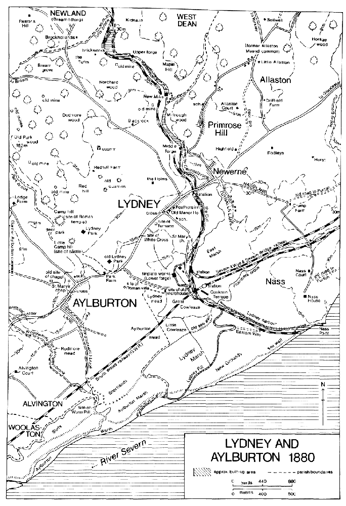
LYDNEY AND AYLBURTON 1880
After the Second World War, against a background of the national housing shortage and the needs of the new factories that were established in Lydney, the rural district council continued to develop its Tutnalls estates. Until its schemes could be completed a hutted camp in the grounds of Nass House, occupied by the American army during the war, was used until the mid 1950s as temporary housing. (fn. 175) The council enlarged the Nass Lane estate in the late 1940s, (fn. 176) and in 1950 began a large new estate based on Harrison Way, where 120 houses had been built by 1957. (fn. 177) In 1956 it began building small semidetached bungalows for old people at Klondyke Avenue on the north side of Tutnalls, and that estate eventually included c. 100 such dwellings. (fn. 178) In the late 1960s and the early 1970s the council built some blocks of low-rise flats at Tutnalls and in the town, on the west side of Bream Road. (fn. 179) By 1972 there were 666 councilowned dwellings in Lydney. (fn. 180) Private building began again in 1957 with the first houses of the Highfield estate, in the angle of Nass Lane and Highfield Road; (fn. 181) in 1964 the Lakeside estate of over 100 houses, on the south edge of Tutnalls, (fn. 182) and the Templeway West estate, on land of the Holms farm adjoining Templeway, were begun; (fn. 183) 2and in 1966 the Lynwood Park estate on the east side of Springfield Road was begun. (fn. 184) All those estates were enlarged at intervals during the next 25 years, the Lynwood Park estate merging with another estate higher up the hill to engulf the 19th-century hamlet of Primrose Hill.
On the main street of the town there was piecemeal redevelopment during the later 20th century. The Lydney end of the town remained relatively little affected in 1990, while the Newerne end had become the principal shopping area, aided in particular by a new bus station opened at Hams Road at the north end of Tutnalls Street in 1960 (fn. 185) and by the building of a large supermarket with adjoining public car park on the north-west side of the main street in the 1970s. (fn. 186)
North of Lydney town there were a few outlying dwellings, the earliest of them probably the Holms, west of the Bream road. In 1558 it was the centre of a freehold estate belonging to the Hyett family, (fn. 187) which sold it to the Winters in 1600, (fn. 188) and the farmhouse was rebuilt in the 19th century. There was a farmhouse at Blackrock on the Bream road further north by 1600. (fn. 189) Three ironworks on the Newerne stream above Newerne had groups of cottages for the workers by 1844. (fn. 190) Most of the cottages were dilapidated in 1889 and were probably demolished soon afterwards when the works were abandoned, leaving a small group at New Mills, the middle site, in 1990. Of the works themselves there were then only some ruins at Upper Forge, but the beds of the great ponds, which filled the valley bottom for over a mile, (fn. 191) and the stone-built dams remained.
South of Lydney town the harbour, the railways, and the growth of the tinplate works at Lower Forge caused sporadic building at the far end of Church Road in the 19th century. Two short rows of cottages, one of them on the site of an old warehouse, were built early in the century near the old head of Lydney Pill, just north of the later South Wales railway line. (fn. 192) South of the railway, beside the head of the harbour, the Severn & Wye Railway Co. built Cookson Terrace, named after its chairman Joseph Cookson, in 1859. (fn. 193) It is formed of nine gabled dwellings, of which the central one is larger than the others and housed the Railway hotel until c. 1970. (fn. 194) Before 1880 the part of Church Road between the church and the bridge over the Cut was diverted to the west and renamed Station Road, (fn. 195) and three terraces of cottages were built on its new straight course in 1898–9. (fn. 196) From the early 1940s land adjoining Station Road and on the north-east side of the harbour was extensively developed for industry. (fn. 197)
South-west of Lydney town, by the boundary of Aylburton tithing, a small hamlet called Overstreet formed on the main Chepstow road. (fn. 198) In the early 17th century it contained several houses, (fn. 199) but most were replaced or became outbuildings to the large manor house called Lydney Park that was built there c. 1690. (fn. 200) Overstreet Farm mentioned in 1660 and again in 1715 (fn. 201) was probably on the site west of the manor house that was later occupied by stables and a keeper's house. In the early 19th century a substantial farmhouse called Park Farm was built south-west of the manor house for the home farm of the Lydney estate. (fn. 202) Lydney Park was demolished and replaced by a new house built on the hillside to the north-west in the late 19th century but the estate was still farmed and administered from buildings at the old site in 1990.
The tithing of Nass (usually spelt Naas in the late 20th century), south-east of Lydney, was settled by 1066. (fn. 203) Nass Court, site of the ancient manor house, and Nass House, built in the mid 17th century, stand close to the river at the end of Nass Lane and were once part of a larger hamlet. In 1651 there were three small farmhouses on the same part of the lane, but in the following year William Jones, owner of Nass House, bought them (fn. 204) and he probably demolished them soon afterwards. (fn. 205) In 1651 there was also a dwelling at Plummer's Farm, where Nass Lane crosses Plummer's brook, and another at Crump Farm, where the lane joined the old road from Purton hamlet; both farmhouses were tenanted by members of the Crump family, (fn. 206) which probably bought the freehold of Crump Farm later in the 17th century. (fn. 207) Cliff Farm, which stands above the river on the old Purton– Nass road, probably occupies the site of a farmhouse which William Jones also added to his estate in 1652. (fn. 208) All three of the outlying farmhouses in Nass tithing were rebuilt during the 18th century or the 19th.
Purton tithing, at the north-east end of the parish, was also inhabited by 1066, (fn. 209) and later comprised scattered farmsteads and a small hamlet on a cliff above the mouth of Lanes brook. The inhabitants of the hamlet gained their livelihood in part from the river trade, fisheries, and the passage across the Severn. A chantry chapel founded there in 1360 (fn. 210) was probably intended to serve travellers using the crossing, who were later accommodated by a passage house inn. The inn, mentioned from 1726, (fn. 211) had the sign of the Ship in the early 19th century (fn. 212) and became the Severn Bridge hotel after the opening of the nearby railway bridge; (fn. 213) it remained open as the Old Severn Bridge hotel in 1990. In 1651 the hamlet included a manor house and a number of small farmhouses. (fn. 214) In 1990 it comprised only the manor house, the substantial early 18thcentury hotel building, and two smaller houses.
The farmsteads of Purton tithing were mostly built on hilltop sites. Two were the centres of medieval freehold estates: Wellhouse, overlooking the river south of Purton hamlet, was demolished in the 18th century, (fn. 215) and Warren, above the Plummer's brook valley, was unoccupied from c. 1930 (fn. 216) and survived as a roofless ruin in 1990. Warren was rebuilt in the earlier 17th century as a stone farmhouse on a symmetrical plan. The main range, which is raised above a rock-cut cellar, has a central two-storeyed porch on the westside and a staircase projection on the east. The roundheaded wooden doorway with carved decoration in the spandrels was one of the few features still intact in 1990. A house near the road junction at the summit of Gurshill, and Nursehill and the Wards, further south, were all recorded from the early 17th century. In 1607 Nursehill was on lease to a branch of the Donning family of Purton, (fn. 217) which bought the freehold later in the century. (fn. 218) The farmhouse is a long range of the earlier 17th century, described as new-built in 1651, (fn. 219) but it was much altered in the 19th and 20th centuries. Stone gate-piers were built opposite the west entrance in the later 17th century. A house beside Lanes brook where the Gloucester–Chepstow road entered the parish was mentioned at the beginning of the 17th century, (fn. 220) and another called Purlieu House in 1739 (fn. 221) was perhaps at the site of Purlieu Farm, where the farmhouse was replaced by a bungalow in the later 20th century. On the Purlieu common four cottages were built by squatters before 1680 (fn. 222) but at the inclosure in 1864 only two survived, on an encroachment adjoining the parish boundary. (fn. 223) That no significant settlement was established was presumably due to the vigilance of the commoners, who in 1807 were reported to be active in suppressing encroachments and illegal dwellings. (fn. 224) On the former Needs Top common, just within the parish, near the Forest settlement of Oldcroft, a few cottages were built soon after the inclosure. (fn. 225)
Allaston tithing lay between Plummer's brook and the Newerne stream. Its principal farmsteads, called Soilwell, Allaston Court, Rodley Manor, and Hurst, were established in the Middle Ages as the centres of small manors. (fn. 226) Driffield Farm (formerly Lower Allaston Farm) (fn. 227) on Driffield Road, leading up the hill from the main Gloucester road, is an L-shaped 17th-century farmhouse which was altered in the 19th century. A farmhouse stood at the Hulks by the Yorkley road near the north end of the tithing in 1668 (fn. 228) but the site comprised only farm buildings in the early 19th century. (fn. 229) A pair of farm cottages was later built there and was being restored as a single house in 1990. About 1820 a large villa called Highfield was built beside the Gloucester road north-east of Newerne, perhaps for the ironmaster John James (d. 1857), who was living there by 1839. (fn. 230)
By 1680 five cottages had been built on Allaston Meend common and, in spite of the manor court's repeated orders that they be demolished, were still there 25 years later. (fn. 231) Those cottages, though none of that date survived in 1990, evidently began the formation of the hamlet of Primrose Hill, on the narrow strip of Allaston Meend that extended down the road to Newerne. In the early 19th century there were two loose groups of cottages, one around the junction with the lane to Allaston Court (later Court Road) and the other at a place called Lower Meend near the south end of the common. Following inclosure, (fn. 232) the building of cottages for industrial workers between the two older groups in the late 1860s and the 1870s enlarged Primrose Hill into a long roadside settlement. The new cottages, mostly of the dark Forest sandstone, were set square on to the road unlike the pre-inclosure dwellings. (fn. 233) A school was built for the hamlet in 1876 and a mission church in 1903, (fn. 234) and the Severn View public house near Lower Meend had opened by 1880. (fn. 235) Before the First World War and during the 1920s and 1930s there was much infilling with new houses and bungalows, (fn. 236) and from the 1950s bungalows were built along the road above Primrose Hill, linking the hamlet to a small group of late 19th-century cottages near the junction with Driffield Road. In the late 1960s and early 1970s a large private housing estate, mainly of bungalows, was built on the east side of Primrose Hill on land of Allaston Court farm, (fn. 237) and it was extended in the late 1980s.
Aylburton village, in the south-west part of the ancient parish, was a populous settlement from the early Middle Ages and had a chapel of ease by 1219. (fn. 238) The village evolved as a single long street on the Gloucester–Chepstow road, but its chapel was built high above the village on a spur of land, where there may have been a prehistoric fortification. (fn. 239) At the junction of the village street and the lane that led up to the chapel (called Chapel Hill) stands a stepped 14th-century cross, similar to that at Lydney. At the start of the 17th century there were houses at the head of Stockwell Lane, which led from the south-west end of the village to the fields on the riverside level and the site of Wose Pill, and others at Millend (later Milling) at the north-east end of the village. (fn. 240) Between those two points the street was evidently built up with small farmhouses, for 17 houses with small farms attached belonged to the Winter's Aylburton manor in 1718. (fn. 241) Only a few of the early farmhouses survived in 1990 and those had been much altered in the modern period. The oldest (no. 32, Aylburton High Street) was possibly the messuage of one of two freehold estates absorbed by Aylburton manor in the late 16th century. (fn. 242) Its entrance probably preserves the line of the screens passage of a small medieval hall, from which there survives an embattled dais beam, with cut-back shields and heads, and a smoke-blackened central cruck truss and windbrace. North of the hall the service end was reconstructed in the 17th century, perhaps when an upper floor and chimney stack were inserted in the hall, and the adjoining dwelling on the south appears to preserve the form of a 17th-century cross wing. A small L-shaped 17th-century building, housing the Cross inn in 1990, stands at the foot of Chapel Hill, and Old Court House, on the south-east side of the village street, is another small farmhouse of similar type, much altered and restored. Cross Farm, south-west of the junction with Chapel Hill, incorporates part of an early house but was remodelled in the late 19th century; a small factory for processing bacon was built adjoining it in 1922. (fn. 243) A short row of cottages near the bottom of the lane leading up towards Coleford is probably 17th-century in origin.
The consolidation of the farmland into two or three large farms and the growth in the number of tradesmen and tinplate workers in Aylburton led to much alteration in the character and appearance of the village during the 19th century. In the mid 19th century a continuous row of cottages, mostly faced in roughcast, was built along the south-east side of the street from opposite the Coleford road to near Park brook, and between 1890 and 1910 stone-built estate cottages, usually in pairs, were built for the Lydney estate in various parts of the village. (fn. 244) The medieval chapel was taken down in 1856 and re-erected on a site more convenient for the villagers near the bottom of the Coleford road, which was named Church Road. A school was built on the opposite side of Church Road in 1870. (fn. 245) Between 1936 and 1938 Lydney rural district built four pairs of council houses on Stockwell Lane, (fn. 246) and in 1950–1 it built a small estate called Milling Crescent east of Church Road, (fn. 247) adding some old people's bungalows there in the late 1950s and early 1960s. (fn. 248) Later in the 20th century a few small private houses were added to the village street, and some larger, detached dwellings were built on Chapel Hill near and above the old site of the chapel.
The few ancient outlying dwellings of Aylburton tithing included Lodge Farm, established before 1717 by the owners of the Lydney estate on the west side of the park woodlands, (fn. 249) and Prior's Mesne Lodge (later Prior's Lodge) high on the north boundary. The south part of the Prior's Mesne estate, a former coney warren, was sold in the 1830s (fn. 250) and later formed the grounds of three houses. A small farmhouse called the Warren, which stood close to the St. Briavels boundary by the early 18th century, (fn. 251) was perhaps the home of the warrener employed on the estate in 1703; (fn. 252) it was enlarged to form a substantial house c. 1890. (fn. 253) Another farmhouse, built a short way north-east of the Warren by the early 19th century, was enlarged and remodelled in Tudor style in the middle of the century and given terraced gardens, becoming known as Prior's Mesne House. (fn. 254) In the 1890s its owner Surgeon-General Henry Cook created a 'wild garden' of exotic plants in part of its grounds. (fn. 255) Part of the former warren lying east of the Alvington road was sold in 1832 by James Croome of Berkeley to his brother Daniel, an attorney, who built himself a house there before 1843, later enlarging it. In 1858 a new owner William Knight built Devonshire Villa (later Aylburton Lodge) beside Croome's house, which was demolished a few years later to make way for a coachhouse and stables. (fn. 256) South of the Prior's Mesne estate, Rockwood, a Regency villa with verandah and ground-floor bow windows, was built beside the Aylburton–Coleford road c. 1815.
Aylburton common, occupying much of the lower slopes of the tithing, was apparently not settled at all before the beginning of the 19th century. Before 1818 six or seven small cottages were built on encroachments at Upper Common where lanes form a triangle on a plateau. (fn. 257) A few more houses were added in the same area after inclosure in 1864, and in the later 20th century most of the older cottages were restored and extended and new houses built among them. Other houses were built after inclosure near the lower edge of the common in the valley of Woodwards brook, where the Traveller's Rest beerhouse had opened by 1880. (fn. 258) About 1907 Sandford Terrace, (fn. 259) a row of brick houses, was built further down the valley, overlooking the Chepstow road, and other houses were built in the same area later in the century.
In 1327 94 inhabitants of the parish were assessed for subsidy, 42 of them in Aylburton. (fn. 260) In 1563 there were said to be 155 households in the parish, 50 of them in Aylburton. (fn. 261) In 1603 there were said to be 509 communicants, (fn. 262) and in 1608 171 able-bodied men were mustered, distributed as 60 in Aylburton tithing, 52 in Lydney tithing, 24 in Allaston tithing, 19 in Purton tithing, and 16 in Nass tithing. (fn. 263) In 1650 a total of only 104 families was recorded, which, if accurate, suggests a loss of population, perhaps accentuated by local dislocation during the Civil War. (fn. 264) About 1710 the population was estimated at c. 700 in 153 houses, (fn. 265) and there had apparently been little change by c. 1775, when there were said to be 661 inhabitants, made up of 246 in Lydney, 231 in Aylburton, 105 in Allaston, 44 in Purton, and 35 in Nass. (fn. 266) By 1801 the total population had risen to 1,032, with 783 in Lydney, Allaston, Purton, and Nass, and 249 in Aylburton. In the earlier 19th century, as the parish began to benefit from its docks and tinplate works, the population increased by some 2½ times. Lydney and the three north-eastern tithings had 1,989 inhabitants by 1851, and the population of that area continued to grow steadily, reaching 3,559 by 1901, 4,811 by 1951, and, following the growth of housing estates, 7,246 by 1981. Aylburton tithing (later the civil parish) also maintained a steady rise in population during the 19th century and early 20th: it rose to 588 by 1851, 731 by 1901, and 921 by 1921. There was then a decline to 718 by 1981. (fn. 267)
Although the parish had a number of lesser gentry families in the early modern period, including the Jameses of Soilwell and the Joneses of Nass, the influence of the owners of the large Lydney estate was paramount. It continued after the industrialization of the town, with the Bathursts providing many of the new amenities, but industrialists also played a role in the community, among them R. B. Thomas (d. 1917), managing director of the Lydney tinplate works, (fn. 268) and G. B. Keeling (d. 1894), secretary and later managing director of the Severn & Wye Railway Co. (fn. 269)
Some inns of the town are mentioned above. There was a total of 14 public houses in 1891. (fn. 270) A friendly society with 70 members was meeting in Lydney by 1804. (fn. 271) A mechanics' institute was founded in 1843 (fn. 272) and in 1897 there was a mutual improvement society. (fn. 273) By 1879 assembly rooms had opened at Newerne, (fn. 274) and from 1889 the new town hall was the principal public meeting place. The town hall was built by a non-profit making limited company, which vested it in trustees in 1957, and in 1968 it was transferred to the parish council. (fn. 275) The Lydney Institute, opened in 1897 principally to house the school of science and art, also included a library, reading room, and billiards room, (fn. 276) and it came to be used as a social club by the workers at the tinplate factory. (fn. 277) The Regent Hall, in Bath Place at Newerne, was built in 1930 by the Lydney branch of the Labour party but was also used by other organizations, including a W.E.A. branch, whose members started a public library in a disused shop in Newerne Street in the mid 1930s. (fn. 278) A branch of the county library had opened by 1957 and moved to new premises in Hill Street in 1963. (fn. 279) There was a Lydney band in 1859, (fn. 280) and a new drum and fife band was formed in 1890 and a brass band in 1892. (fn. 281) A cinema called the Lydney Picture House was opened in 1913 and closed in 1964. (fn. 282) A newspaper, the Lydney Herald, was published for a few months in 1863, and another, the Lydney Journal, appeared between 1865 and 1867. The Lydney Observer, a weekly, was begun in 1875, (fn. 283) and continued publication in 1990 as part of the Forest of Dean Newspapers group.
In 1789 Thomas Bathurst organized horse races on Lydney mead south of the town. Apparently a new venture that year, (fn. 284) the meeting does not seem to have become a regular event. From the late 19th century Lydney developed a strong sporting tradition. A rugby club was formed in 1887 and c. 1920 moved to a ground south of Newerne. The team became one of the most successful in the region, many players reaching the county side. (fn. 285) A football club for Lydney and Aylburton was formed c. 1887 and was succeeded by a new Lydney club c. 1911; a hockey club was formed c. 1905; (fn. 286) and a cricket club played on a pitch in Lydney park in the early 20th century. (fn. 287) A golf club, with links near the Holms, was formed in 1909, (fn. 288) and in the mid 20th century a golf course was laid out south of Tutnalls. (fn. 289) In 1920 an open-air swimming bath was built near the Chepstow road south-west of the town and given to the inhabitants of Lydney and Aylburton by Charles Bathurst, later Viscount Bledisloe. (fn. 290) After the Second World War most sporting activities were concentrated on a new recreation ground laid out south of Newerne, between the Newerne stream and the Cut, where Viscount Bledisloe and the local industrialist John Watts gave land in 1946. They inaugurated the Lydney Recreation Trust, and during the next eight years marshy land was drained, by diverting part of the stream and digging a lake, and cricket and football pitches and tennis courts were formed. A new cricket square laid later was used for occasional county games after 1963. In 1968 the trustees conveyed the whole recreation ground, which other gifts had enlarged to 51 a., to the Lydney parish council. (fn. 291) In 1990 the council also administered Bathurst Park, a public park north-east of Church Road, which Charles Bathurst and his son (later Viscount Bledisloe) gave to the town in 1892 to mark the latter's coming of age. (fn. 292) A yacht club was established c. 1962 with its premises at a former boatbuilding yard at the entrance to Lydney harbour. (fn. 293)
In Aylburton an inn called the Hare and Hounds had opened by 1796 when two friendly societies for inhabitants of the village met there. (fn. 294) The inn, which stood near the north-east end of Aylburton, was demolished in the mid 20th century, (fn. 295) but two other public houses, the George and the Cross, both open by the 1870s, (fn. 296) served the village in 1990. A field adjoining the village was used as a recreation ground from 1898, and from c. 1933 a local committee managed it as a playing field. A village hall was built on the south-east side of the village street in 1920–1 as a memorial to the dead of the First World War. (fn. 297)
Mains water was supplied to Lydney town in 1902 when Lydney rural district built a pumping station at Ferneyley springs near the west boundary of Aylburton and a reservoir above Lodge Farm near its east boundary. (fn. 298) In the early 1950s boreholes at Rodmore, in St. Briavels parish, and old mine workings at the Tufts were tapped for additional supplies, and a new reservoir was built at Chapel Hill, in Aylburton, in 1956. From 1969 the supply was supplemented from the Buckshaft scheme of the North West Gloucestershire water board, in which the rural district was a partner, and from 1976 most of the town and parish received river Wye water from the Mitcheldean works of the SevernTrent water board. (fn. 299) Aylburton had a supply from 1912 when a subscription was raised to lay pipes from a spring above the village, and some houses continued to use that source after 1950 when the rural district's mains were extended to the village. (fn. 300) The Lydney Gas Light and Coke Co. was established by local businessmen in 1860, reviving a company first formed in 1856. It built its works beside the Cut south of Newerne and began to supply Lydney and Newerne in 1861, when 44 street lamps were lit at the expense of the parish vestry and 200 private users were connected. Extensions to the mains matched the growth of the town in the late 19th century and early 20th, and in 1915 there were 149 public lamps, then the responsibility of the parish council. (fn. 301) In 1946 the company took over the Coleford gas company and began a considerable extension to its area of supply, continued after nationalization in 1948. (fn. 302) The Lydney gasworks were closed in 1957. (fn. 303) Electricity was laid on to the town c. 1925 by the West Gloucestershire Power Co., which had built its power station at Norchard colliery in the parish. (fn. 304) A sewerage system was built by the rural district council c. 1900 (fn. 305) with the main outfall running under the fields to the Severn beyond the New Grounds. (fn. 306) A treatment plant was built and new sewers laid in the 1970s. A volunteer fire brigade for the town had been formed by 1912. (fn. 307) In 1932 the rural district established a new brigade and built a fire station at the entrance to Oxford Street, which remained in use after the brigade was absorbed by the county fire service in 1948. (fn. 308)
A cottage hospital to serve Lydney and Aylburton was opened in a house in Aylburton village in 1882 by Mary, wife of Charles Bathurst; it was maintained by subscriptions, collections, and the patients' contributions. In 1908 it moved to a new building at the top of Grove Road, north of Lydney town. The hospital was enlarged between 1935 and 1937 by the addition of a maternity wing and out-patient department, given by Viscount Bledisloe as a memorial to his first wife, and a new physiotherapy centre was completed in 1963 as a memorial to Viscount Bledisloe. The hospital passed to the local hospital management board in 1948 (fn. 309) and, as the Lydney and District hospital, it remained open under the Gloucester district health authority in 1990. The authority also ran a health centre on the north of Newerne Street. In 1955 a cemetery, managed by Lydney parish council, was opened on the west side of Church Road. (fn. 310)
During the Civil War there were some minor actions and considerable destruction and plundering at Lydney. Sir John Winter fortified his manor house, White Cross, as a royalist stronghold, and the fighting, mainly during 1644 and early 1645, included skirmishes at Soilwell and Nass where the parliamentary forces of Gloucester had placed garrisons in an attempt to contain Winter. (fn. 311)
The composer Herbert Howells (1892–1983) was born and educated at Lydney, (fn. 312) and the Chaucerian scholar Professor Nevill Coghill (1899–1980) lived at Aylburton in his later years. (fn. 313) F. S. Hockaday (d. 1924), a colliery proprietor who lived at Highbury House (fn. 314) on the north side of the town, devoted many years to studying and indexing the archives of Gloucester diocese. (fn. 315)
MANORS AND OTHER ESTATES.
Burgred, king of Mercia 852–74, granted an estate at Lydney to Ethelred. Ethelred evidently gave it to Glastonbury abbey (Som.), (fn. 316) but in 972 an estate of 6 'mansae' in Lydney belonged to Pershore abbey (Worcs.). (fn. 317) Soon after the Norman Conquest four estates in Lydney were granted by their lords to William FitzOsbern, earl of Hereford, who formed them into a single manor: they were the 6 hides of Pershore abbey, 3 hides of the bishop of Hereford, and a total of 3½ hides held by two thegns. (fn. 318) An estate of 2½ hides at 'Niware' which was formerly part of Herefordshire but which the sheriff of Gloucestershire added to his county 'in the time of Earl William' can probably be identified as Newerne (fn. 319) and may have been one of the thegns' estates. It seems most likely that FitzOsbern's new manor comprised the later Lydney, Allaston, and Aylburton tithings. Nass, Purton, and Poulton (in Awre) were also amalgamated by FitzOsbern, for whom the Lydney area evidently had a strategic and logistical significance in the years immediately following the Conquest, presumably as a crossing-point of the Severn; he also built a small castle on the opposite bank, in Berkeley. (fn. 320)
FitzOsbern's estates passed to the Crown on the rebellion of his son Roger in 1075, and the later pattern of tenures and overlordships indicates that all of Lydney parish, with the probable exception of Aylburton, was included in a royal grant to the earls of Warwick. William (d. 1184), earl of Warwick, is the first found recorded in connexion with the Lydney estates (fn. 321) but the earls may have been in possession for many years before that. (fn. 322)
Later the part of the parish based on the twin settlements of Lydney and Newerne was included in two manors, one held in demesne by the earls of Warwick and the other held from them by the Talbot family. The earls' manor, which became known as LYDNEY WARWICK, (fn. 323) was recorded from 1205, when during the minority of Henry, son of Earl Waleran, it was granted to Thomas Basset, (fn. 324) Henry's future father-in-law. It descended with the earldom of Warwick until the late 15th century. (fn. 325) In 1317 it was granted to Hugh Despenser the elder during the minority of Thomas de Beauchamp; (fn. 326) in 1397 on the forfeiture of a later Earl Thomas de Beauchamp it was granted to John de Montague, earl of Salisbury; (fn. 327) and Margaret, widow of the younger Thomas, held it in dower from 1401 to 1406. (fn. 328) In 1478 and 1486 it was in the hands of the Crown during the minority of Edward, heir of the attainted and executed George, duke of Clarence and earl of Warwick, (fn. 329) but in 1487 it was in possession of Anne, widow of Richard Neville, earl of Warwick. She granted it that year to the Crown. (fn. 330) The Crown retained Lydney Warwick manor (fn. 331) until 1547 when it granted it to Thomas Seymour, Lord Seymour, (fn. 332) who was attainted and executed in 1549. In 1550 the manor was granted to John Dudley, earl of Warwick, (fn. 333) who sold it in 1551 to Sir William Herbert, (fn. 334) created that year earl of Pembroke. Pembroke sold it in 1560 to William Winter, (fn. 335) with whose other Lydney estates it then descended.
A manor later called LYDNEY SHREWSBURY (fn. 336) was held by Richard Talbot from the earl of Warwick in 1285; (fn. 337) the overlordship of the earls of Warwick was recorded until the mid 16th century. (fn. 338) Richard Talbot died in 1306 and Sarah Talbot, apparently his widow, held the manor in 1316. (fn. 339) It passed to Richard's son Gilbert, later Lord Talbot, whose estates were forfeited temporarily after his capture at Boroughbridge in 1322. From Gilbert (d. 1346) (fn. 340) the manor descended in direct line to successive Lords Talbot, Richard (fn. 341) (d. 1356), Gilbert (d. 1387), (fn. 342) and Richard. Richard granted it in 1392 to Joan, daughter of Thomas of Woodstock, duke of Gloucester, on her betrothal to his son Gilbert. On Joan's death in 1400 it reverted to Richard's widow Ankaret, (fn. 343) who married Thomas Neville (d. 1407) (fn. 344) and died in 1413. (fn. 345) Ankaret was succeeded by her son Gilbert, Lord Talbot (fn. 346) (d. 1418). His daughter Ankaret died in infancy in 1421 and the manor passed to her uncle John Talbot, later earl of Shrewsbury. (fn. 347) It then descended with the earldom of Shrewsbury, (fn. 348) Catherine, widow of John Talbot (d. 1473), holding it in dower. (fn. 349) In 1552 Francis Talbot, earl of Shrewsbury, conveyed Lydney Shrewsbury to the earl of Pembroke, (fn. 350) who sold it, probably with Lydney Warwick in 1560 and certainly by 1562, (fn. 351) to William Winter.
William Winter's father John Winter (d. 1546), a sea captain of Bristol and Deptford (Kent), owned a house at Lydney, (fn. 352) and William was described as late of Lydney in 1554 when he was pardoned for joining Wyatt's rebellion. (fn. 353) William, who was knighted in 1573 and was one of the commanders against the Armada in 1588, (fn. 354) added numerous estates in the parish to the two Lydney manors and was succeeded at his death in 1589 by his son Edward. (fn. 355) Edward, who also followed a naval career and was knighted in 1595, (fn. 356) was warden of the Forest and constable of St. Briavels 1601–8. (fn. 357) He died in 1619 and was succeeded by his son John, (fn. 358) who was knighted in 1624 and became secretary to Queen Henrietta Maria in 1638. In 1640, for a large sum of money, he had a grant in fee of the bulk of the royal demesne land of the Forest. (fn. 359) In the Civil War Sir John led the royalist forces in the Forest area, engaging in numerous skirmishes with the parliamentary garrison of Gloucester until driven from Lydney in 1645. (fn. 360) His estate was discharged from sequestration in 1647, (fn. 361) but in 1649 he was among 12 leading royalists condemmed to perpetual banishment and confiscation, and, failing to leave England, he was imprisoned in the Tower. (fn. 362) In 1651 or 1652 he bought the estate back from the commissioners for delinquents' lands, but to meet the resulting debts many farms in Purton, Nass, and the adjoining parish of Awre were sold to the tenants, and Sir John and his son and heir William also negotiated a long series of mortgages. In 1668, when a further large sale of lands in Awre and Allaston was made, (fn. 363) Sir John still had some rights in the estate (fn. 364) but he had evidently released them to William by 1674 when William made a will leaving an annuity to his father. (fn. 365) William Winter (d. by 1677) was succeeded by his brother (Sir) Charles (fn. 366) (d. 1698), who left the estate to his widow Frances. (fn. 367) Before 1714 she married Thomas Nevill but, continuing to style herself Dame Frances Winter, retained sole control of the estate. The estate was still subject to the earlier mortgages, part of the burden being cleared by the sale of lands in Aylburton in 1718. Dame Frances died in 1720, (fn. 368) and in 1723 her heirs and trustees sold the Lydney estate to Benjamin Bathurst, a son of Sir Benjamin Bathurst of Cirencester. (fn. 369)
Benjamin Bathurst (d. 1767), who was successively M.P. for Cirencester, Gloucester, and Monmouth, (fn. 370) apparently made his Lydney estate over to his son Thomas before 1759. (fn. 371) Thomas (d. 1791) (fn. 372) was succeeded by his brother Poole Bathurst (d. 1792), who devised it to his widow Anne with reversion to his nephew Charles Bragge. (fn. 373) Bragge, who succeeded on Anne's death in 1804 (fn. 374) and assumed the name Bathurst, was Chancellor of the Duchy of Lancaster 1812–23 and died in 1831. The estate, which in 1818 comprised 3,435 a. of farmland, woodland, and parkland in the parish, (fn. 375) passed successively to his sons Charles (d. 1863) and the Revd. William Hiley Bathurst (fn. 376) (d. 1877), to William's son Charles (d. 1907), and to Charles's son Charles. The youngest Charles Bathurst, who was governorgeneral of New Zealand 1930–5, was created Baron Bledisloe in 1918 and Viscount Bledisloe in 1935. (fn. 377) He died in 1958 and the estate and viscounty passed to his son Benjamin (d. 1979) (fn. 378) and then to Benjamin's son Christopher. Some farms and woodland in the north-east part of the parish were sold in the 20th century but other land in Aylburton and in the adjoining parish of Alvington was acquired, and the estate comprised over 1,214 ha. (3,000 a.) in 1990. (fn. 379)
An early lord of Lydney presumably occupied the small castle which stood on Little Camp hill in Lydney park, overlooking the Park brook valley. Built some time in the 12th century and probably demolished soon after the end of that century, it comprised a rectangular keep, a walled inner court, and an outer bailey defended by a ditch and bank. (fn. 380) A manor house was recorded on Lydney Warwick manor in 1315 (fn. 381) but there was no house in 1369. (fn. 382) The Talbots had a capital messuage on their manor in 1322, (fn. 383) and in 1558 the site of Lydney Shrewsbury manor was called Abbot's Court. (fn. 384) The reason for that name is obscure, as there appears to have been no monastic owner in that part of the parish after Pershore abbey in the 11th century. A house in the main street of Lydney, a short way north-east of the market place, was known as the Old Manor House in 1880 (fn. 385) and was probably the original dwelling of the Winter family. John Winter's house was evidently a substantial one in 1538 when he complained that it had been attacked by a mob led by members of the Baynham family, (fn. 386) and his son William's mansion was described as next to the cross in 1558. (fn. 387) The Old Manor House, a gabled building apparently dating from the 16th century but with later additions, was demolished in 1975. (fn. 388)
Sir William Winter, probably soon after he bought the two Lydney manors, built a large new house called White Cross (fn. 389) just beyond the south-west end of the town, on the south-east side of the Chepstow road. White Cross was fortified by Sir John Winter during the Civil War and in May 1644, under his wife Mary, it withstood an attack by the parliamentary forces of Edward Massey. When he was forced to leave Lydney in April 1645 Sir John burned the house down. (fn. 390) Part of it apparently remained standing in 1673, by which time an ironmaking furnace had been built on the northeast part of the grounds. William Winter was then living at a house called the Court, (fn. 391) perhaps the one later called the Old Manor House. The site of White Cross was later marked only by earth banks, presumably raised as part of its Civil War defences.
A new manor house, known as Lydney Park, was built by Sir Charles Winter at Overstreet at the south end of the deer park, close to Aylburton village. He apparently completed it in 1692. (fn. 392) It was a tall, plain house on an L plan, having three storeys and attics and a front of seven bays to the south-east. Improvements that Benjamin Bathurst was making in the late 1720s (fn. 393) may have included the seven-bay orangery that later adjoined the north-east corner. In the early 1770s the entrance front was to the south-west, where there was a walled garden (fn. 394) and a stable block. About 1830, as part of alterations designed by Thomas Greenshields, the orangery was remodelled and a floor of service rooms added above it. (fn. 395) Landscaping of the adjoining parts of the park in the late 1720s included the planting of clumps of elms, (fn. 396) and in 1736 the main Chepstow road, which ran next to the house, was diverted to the south-east and the park extended to the new line. (fn. 397) By the early 1770s the park had a number of ornamental features, and a terrace and Gothick summer house had been built on Red hill on the north-east side of it. (fn. 398)
In 1877 a new Lydney Park house was built further north and higher up the hillside than the old one, which was demolished, except for part of the stable block, in 1883. The new house, a Tudor-style mansion in rusticated stonework with a castellated tower at one corner, was designed by C. H. Howell. (fn. 399) From 1940 to 1948 it was occupied by a school and Viscount Ble disloe lived at Redhill House, built in the late 19th century on the north-east side of the park. From 1950 Lydney Park was occupied by his son and eventual successor, who created an ornamental garden in a wooded valley northwest of the house. (fn. 400)
In 1066 Earl Harold held the manor of NASS, assessed on 5 hides, and soon after the Conquest William FitzOsbern joined it to the manors of Purton and Poulton (in Awre) to make a single estate. (fn. 401) Following the rebellion of FitzOsbern's son Roger, Nass, Purton, and Poulton were in the king's hands in 1086 and they later resumed their separate identities, apparently after inclusion in a royal grant to the earls of Warwick. (fn. 402) Nass manor is recorded again in 1300 when Walter of Nass was its lord, (fn. 403) and in 1322 Walter held a house and 50 a., presumably comprising only the demesne land, from the Talbots' manor; (fn. 404) the manor continued to be held from Lydney Shrewsbury manor. (fn. 405) Thomas Rigg and Catherine his wife held Nass manor in 1400, (fn. 406) and in 1419 their daughter Joan held it with her husband Robert Greyndour. (fn. 407) Nass manor then descended with Clearwell, in Newland, until 1611 when it was among estates of the Baynham family (fn. 408) that passed to the Vaughans. Between 1658 (fn. 409) and 1668 John Vaughan of Ruardean sold the manor with the house and farm called Nass Court, to William Jones, owner of the Nass House estate, who had been lessee of the farm since 1650 or earlier. (fn. 410)
The Jones family was established at Nass by 1577, when William Jones owned a small freehold, (fn. 411) and it later bought from the Winters a larger estate. The Winters' estate at Nass included land that Joan Greyndour gave to endow a chantry at Newland in 1446 and William Winter bought in 1559, (fn. 412) and possibly also land that Joan and her second husband alienated in 1481. (fn. 413) In 1607 Sir Edward Winter owned several small farms, one of which was on lease to Charles Jones; (fn. 414) in 1651 three were on lease to Charles's son William, who bought the freehold of the estate the following year. (fn. 415)
William Jones's combined estates at Nass passed at his death in 1667 or 1668 (fn. 416) to his son Charles (d. 1689). About 1679 Charles settled Nass on the marriage of his son William, (fn. 417) whose widow Anne held it in 1685. (fn. 418) It passed to Roynon Jones (d. 1732), (fn. 419) whose widow Anne settled Nass House and a large part of the estate on the marriage of her son William in 1735; she retained Nass Court and other lands, which were confirmed to her for life in 1763. (fn. 420) William Jones died in 1775 (fn. 421) and the Nass estate then passed in direct line of descent to Roynon (d. 1817), (fn. 422) the Revd. Edward (fn. 423) (d. 1847), Edward Owen Jones (fn. 424) (d. 1872), and William Charles Nigel Jones (d. 1915). (fn. 425) In 1916 the estate, comprising Nass House, Nass Court, Cliff Farm, and c. 440 a., was offered for sale by its mortgagees. John Biddle, tenant of one of the farms, (fn. 426) bought the estate c. 1920, and his family owned and farmed it in 1990. (fn. 427)
Early owners of Nass manor may have built a small castle there. In 1558 Nass cliff was known alternatively as 'Nass Castle', (fn. 428) and in 1737 the Joneses claimed that a castle had anciently stood on their manor. (fn. 429) Its most likely site appears to be at Nass Point, at the south end of the cliff, guarding the entrance to Lydney Pill. A hall and farm buildings were recorded on the manor in 1443, (fn. 430) probably at the site of Nass Court, on the west side of Nass Lane. The small farmhouse at Nass Court contains one early 17th-century window and may date from a rebuilding of that date but it has been much altered at a later period. On the lane to the east stands a buttressed barn of eight bays which formerly had a base-cruck roof and probably dates from the 16th century. Nass House, on the lane further south, is a large late 17th-century mansion. It was probably built by William Jones in the 1660s after he had enlarged his estate but it may be on the site of an earlier dwelling of the Jones family. The house, which is largely built of rubble but incorporates some blocks of ashlar, has a north front of seven bays and a south front of six bays with a centre that is recessed to a staircase tower. The elevations are gabled but the tower is capped by a flat roof with a cupola. A service wing was added on the west, probably in the early 18th century, when several of the rooms in the house were panelled. A walled forecourt abuts the house on the south side, and on the north there was a long avenue of lime trees, (fn. 431) felled in the mid 20th century. The house, which has undergone little alteration since it was built, was apparently little used by the Joneses after c. 1770 when they built a new house at Hayhill on their Ruddle manor, in Newnham. (fn. 432)
Before 1066 the manor of PURTON was severed from Awre manor, to which it had been attached as a contributor to the royal farm, and, as mentioned above, it was later included in FitzOsbern's amalgamation of manors. (fn. 433) By the early 13th century Purton had been acquired by Maurice de Gant (d. c. 1230) who granted it at farm to his tenants. (fn. 434) In 1242 Maurice's widow Margaret Somery held Purton with Over (in Almondsbury) from the earl of Warwick as ¼ knight's fee. (fn. 435) It later passed to Maurice's nephew and heir Robert de Gurney (d. c. 1269), whose son Anselm (fn. 436) granted the manor shortly before 1285 to his son William. (fn. 437) By 1303 Purton was held by John ap Adam, (fn. 438) who had married Elizabeth de Gurney, daughter of William's brother John. John ap Adam died c. 1311, and in 1325 his son Thomas granted the whole or the bulk of his Purton estate to John of Walton for life. (fn. 439) In 1328, however, Thomas granted the manor to William of Cheltenham, who then or later had a grant from John of Walton of his interest. (fn. 440) It is probable that in those transactions William of Cheltenham was acting for his patron Thomas of Berkeley, Lord Berkeley, and that later he had the manor in his own right by gift of Lord Berkeley. (fn. 441) In 1360 William gave 12 houses and 12 yardlands at Purton, evidently the bulk of the estate, as the endowment of a chantry chapel, (fn. 442) and in 1366 he granted the remainder of his estate to Maurice, Lord Berkeley, reserving a life interest, which however he surrendered to Maurice the following year. (fn. 443)
The chantry estate and the Berkeleys' estate both continued to be known as Purton manor. The former was sold by the Crown in 1549 after the dissolution of the chantries to Sir John Thynne and Thomas Throckmorton, (fn. 444) and before 1560 it was acquired by William Winter. (fn. 445) The other estate descended with Tucknall manor in Lydney and with Awre manor, (fn. 446) and in 1546 it was held in dower by Queen Catherine Parr, formerly the wife of John Neville, Lord Latimer. (fn. 447) Later it seems to have become regarded as part of Tucknall manor, a survey of which in 1577 included free rents in Purton and the fishing rights adjoining the tithing, (fn. 448) and it evidently passed to the Winters with Tucknall in 1595. Much of the land at Purton was sold to the tenants in the 1650s (fn. 449) but the Winters and their successors the Bathursts retained the manorial rights and some farmland. (fn. 450)
Purton Manor, the chief house of the chantry estate, and the demesne lands belonging to it were sold by the Winters in 1657 to William Donning, (fn. 451) whose family had leased them from before 1607. (fn. 452) In 1673 William (d. 1680) settled most of his estate on the marriage of his son Thomas, (fn. 453) who held it at his death in 1714. (fn. 454) In 1740 and 1752 the estate belonged to Sir John Hynd Cotton, Bt., and others. (fn. 455) By 1791 the owner was Edward Eliot, Lord Eliot (d. 1804), (fn. 456) and the estate, comprising Purton Manor farm, which had absorbed the adjoining Wellhouse farm, and Hill farm, based on a house at Gurshill, passed to his son John Craggs Eliot, (fn. 457) who was created earl of St. Germans in 1815. The earl (d. 1823) was succeeded in his estates and title by his brother William, who sold Hill farm in 1830 to Charles Mathias of Lamphey Court (Pemb.), the promoter of a scheme to build a railway line from the Forest to Purton Pill. (fn. 458) Purton Manor and the rest of the estate were acquired before 1839 by James Croome of Breadstone, in Berkeley. (fn. 459) Croome (d. 1865) was succeeded by his eldest son John James Croome but his younger son Thomas Breadstone Croome (fn. 460) owned the estate by 1870. (fn. 461) James Croome and his successors enlarged their estate to include most of the farms of the east part of the parish, and at his death in 1909 T. B. Croome owned Purton Manor, Warren, Hill, Hurst, Rodley Manor, and Crump farms, a total of c. 900 a. The estate passed to James Croome-Jackman (d. 1925), and was apparently sold and split up before the Second World War. (fn. 462) Purton Manor farm was bought in the late 1940s by Mr. D. J. Aldridge and he and his family owned and farmed it together with adjoining farms in 1990. (fn. 463)
Purton Manor, which stands on a cliff overlooking the Severn, was the home of the priests who served the adjoining chantry chapel until the mid 16th century. (fn. 464) The low west range of the present house was probably built in the 16th century as the central room of a house which was otherwise demolished in the early 17th century when the three-storeyed east block was built. That block has a near symmetrical plan with one room on either side of a central stair; the older range became the kitchen and other service accommodation was provided in a two-storeyed lean- to in the angle between the two ranges. The north-eastern ground- floor room has a moulded plaster ceiling and an overmantel bearing the date 1618 and the initials of members of the Donning family, then the tenants. (fn. 465) West of the house is a 17th-century stable block with three gables and decorated circular windows.
Lands at Lydney that the brothers Ralph and Niel de Mundeville held under the overlordship of Waleran (d. 1204), earl of Warwick, apparently comprised or included an estate that was later called the manor of TUCKNALL. They were succeeded by Richard de Mundeville, (fn. 466) who held ½ knight's fee from the earl of Warwick in 1242. (fn. 467) The estate passed to Philip de Mundeville (fn. 468) who apparently granted it to John of Nass and Walter (or William) Warren; in 1285 they held 1/6 knight's fee from Philip. (fn. 469) In 1303 Walter Warren held 1/10 fee at Tucknall (fn. 470) and his estate, which was later held from Lydney Warwick manor, passed to another Walter Warren by 1346, (fn. 471) and to Thomas, son of Henry Warren, who in 1350 sold it to Thomas of Berkeley, Lord Berkeley. (fn. 472) It then descended with Awre manor, (fn. 473) passing to Sir Edward Winter in 1595. (fn. 474) Tucknall manor has not been found named among the Winters' estates after 1619, (fn. 475) and in 1677 it was described as having been absorbed in Lydney Shrewsbury manor. (fn. 476) In 1577 it comprised a widely scattered group of lands in the eastern tithings of the parish, most of them held freely from it by chief rents. The name of the manor was taken from a place south-east of Newerne, surviving in a corrupt form as Tutnalls: Tucknalls green (fn. 477) and other lands called Tucknalls were mentioned in that area in the late 17th century. (fn. 478)
Before 1538 Walter Yate of Arlingham bought from William Bashe, vicar of Arlingham, a reversionary right to lands in Lydney parish after the life interest of James Cooke, (fn. 479) and at his death in 1546 Walter held the manor of ALLASTON from the Latimers' Purton manor. (fn. 480) He apparently left it, together with his Wellhouse estate at Purton, to a younger son John Yate, (fn. 481) who in 1557 conveyed the house called Allaston Court and lands, then said to be held from Lydney Warwick manor, to Thomas Browne. (fn. 482) In or shortly before 1568 Allaston manor was acquired by William Winter. (fn. 483) The Winters sold much of the land, including Allaston Court farm, in 1668 to Gloucester corporation as trustee of Sir Thomas Rich's school in that city, (fn. 484) and the corporation also acquired Driffield farm from Dame Frances Winter in 1712 in a belated adjustment to meet the value of the lands agreed at the sale of 1668. (fn. 485) The Gloucester United Schools Governors, successors to the corporation's trust, (fn. 486) sold their 292- acre Allaston estate in 1907. (fn. 487) Most of it, including Allaston Court and Driffield farms, was bought then or shortly afterwards by Charles Bathurst and added once more to the Lydney estate. (fn. 488) A farm called Little Allaston and the manorial rights had continued as part of that estate after 1668. (fn. 489) The Lydney estate sold most of its Allaston lands in the mid 20th century. Allaston Court farm was acquired by the tenants, the Liddington family, which retained the house and a small acreage in 1990, most of the land having been sold for building. (fn. 490) Allaston Court was rebuilt in the late 17th century as a gabled stone farmhouse of two storeys and attics, (fn. 491) and in the early 19th century it was doubled in size by an extension to the southwest.
An estate at the north end of Allaston tithing known as SOILWELL, and sometimes as Sully, was said in the late 17th century to have been an assart from the waste of the Forest, (fn. 492) and the fact that it was held directly from the Crown without the intervening lordship of the earls of Warwick or their successors also indicates such an origin. (fn. 493) It was evidently the land called the park of Sully that John of Sully held in 1284 when he was given deer from the Forest to stock it. (fn. 494) No later record of the estate has been found before c. 1600 when it was among estates in the parish that had been acquired by Thomas James, merchant and alderman of Bristol. (fn. 495) The small Warren estate in Purton, named from the family that owned it from 1322 or earlier, (fn. 496) came to Thomas before 1581 (fn. 497) from his mother Margaret, daughter of William Warren of St. Briavels, (fn. 498) and Thomas also bought the Rodleys estate in Allaston. (fn. 499) Thomas James (d. 1619) (fn. 500) was succeeded by his son Edward (fn. 501) (d. 1628), Edward by his infant son Thomas, (fn. 502) who came of age c. 1647 (fn. 503) and died in 1671, (fn. 504) and Thomas by his son Thomas, a minor in the guardianship of his mother Elizabeth until c. 1680. (fn. 505) The last Thomas (d. 1702), who lived at Warren, devised his estates, apart from Rodleys, to his son Edward, (fn. 506) but Soilwell and Warren passed, probably before 1707, (fn. 507) to Thomas's brother William (d. 1727). William was succeeded by his son William, (fn. 508) who was clerk of the peace for Gloucestershire from 1723 until his death in 1742. (fn. 509) The younger William left his estates to be sold, (fn. 510) but his daughter Frances James was described as of Soilwell at her death in 1766. (fn. 511) The James family sold the estate to Richard Williams, who apparently sold to John Townley, the owner in 1791. (fn. 512) Peregrine Townley owned it in 1802. His estate was offered for sale in 1838, when Warren was bought by James Croome and added to the Purton Manor estate. (fn. 513) Soilwell belonged in 1839 to Blanche Taylor. (fn. 514) In 1864 John Trotter Thomas of Coleford owned the house and 124 a. (fn. 515) He sold the estate in 1870 to Arnold Thomas, whose widow put it up for sale in 1920. (fn. 516) Lord Bledisloe bought it soon afterwards and the farmland remained part of the Lydney estate in 1990, (fn. 517) Soilwell house having passed into separate ownership.
There was apparently a house at Soilwell by the late Middle Ages. It was rebuilt in 1661 (fn. 518) as a tall house of stone with two storeys and attics, the ground floor raised on cellars; it has a three-room plan with three chimney stacks on the rear wall. The entrance is by a porch at one end of the central hall and a stair turret rises from a doorway at the other end. The principal rooms were fitted with panelling in the mid 18th century when a small addition was made at the back. The walled front garden with cross paths may be contemporary with the house.
Before 1204 the brothers Ralph and Niel de Mundeville, apparently owners of Tucknall manor, (fn. 519) gave 1½ yardland at a place called Archer's Hall in Lydney to Alan, chamberlain of Waleran, earl of Warwick. Alan granted the land to Kenilworth priory (Warws.) but later granted it to Llanthony priory, Gloucester, which had a quitclaim from Kenilworth (fn. 520) and had two tenants at Archer's Hall in 1287. (fn. 521) Llanthony apparently alienated the estate before the Dissolution. (fn. 522) It was presumably the small manor in the south part of Allaston tithing that was held from Tucknall in the 16th century (fn. 523) and was known as ARCHER'S HALL, ALLASTON, or RODLEYS. William Kingscote (d. 1524) of Kingscote owned houses and lands there, and his son William (fn. 524) had the manor at his death in 1540. William, son of the younger William, succeeded (fn. 525) and his son Christopher Kingscote conveyed the manor in 1590 to Thomas James. (fn. 526) Rodleys manor then descended with Soilwell (fn. 527) until 1689 when Thomas James (d. 1702) conveyed it to his brother Richard, who died without issue in 1694. (fn. 528) Rodleys then reverted to Thomas, who settled it on his wife Joan, and in 1711 Joan joined in a settlement of the manor on their son Edward and his heirs. (fn. 529) By 1752 the manor house was occupied by Thomas James, (fn. 530) who died in 1761. (fn. 531) Edward Jones owned Rodleys manor c. 1775 and in 1791, (fn. 532) George Jones owned the house and 95 a. in 1839, (fn. 533) and the representatives of Elizabeth Anne Jones owned that estate in 1864. (fn. 534) It later formed part of the Croome family's estate. (fn. 535) The house, known as Archer's Hall or Rodleys in 1564 (fn. 536) and as Rodley Manor in the 20th century, was rebuilt in the early 19th century. By 1990, when part of the farmland had been built on, the house was derelict.
In 1285 small unidentified estates were held from the earl of Warwick by Richard de Alington, who had 1/10 knight's fee, Thomas Pavy, who had 1/6 knight's fee, and Hugh de Chavelinworth, who had 1/6 knight's fee. (fn. 537) Richard's estate was perhaps the 1/10 knight's fee in 'Yerdeshulle' that was held by members of the Wyle (or Byle) family in the early 14th century and by Richard Barrett in 1402. (fn. 538) The place name has been identified as Gurshill (fn. 539) and possibly the estate was later represented by one of the farms in that area.
A small manor called HURST in Allaston was held by Thomas Rigg and Catherine his wife in 1400 (fn. 540) and passed with Nass manor to the Greyndours. (fn. 541) It was probably the estate, including 2 messuages and 120 a., that John and Joan Barre conveyed to Thomas Morgan in 1466, (fn. 542) for Thomas a Morgan, alderman of Gloucester, owned Hurst at his death in 1534. (fn. 543) Men called Thomas Morgan of Hurst, probably fathers and sons in succession, died in 1568, (fn. 544) c. 1613, (fn. 545) 1664, and 1704, and Richard Morgan of Hurst died in 1717. (fn. 546) Hurst was later owned by Probert Morgan (d. 1759), (fn. 547) whose widow held it c. 1775, (fn. 548) and the Morgan family still owned the estate in 1791. (fn. 549) In 1839 the house and 233 a. belonged to Henry Morgan Clifford. (fn. 550) In 1864 and 1926 Hurst was part of the Croome family's estate. (fn. 551) In 1942 it was bought by a branch of the Biddle family, and in 1990 the farm, covering 240 a., was owned and worked by Mr. D. R. Biddle. (fn. 552) The house, which stands on a low hill in the south part of Allaston tithing, has a north range of two storeys and attics with a fourbayed, cruck-framed roof. About 1800 the west end of that range was refronted and a new wing was built against its south side.
A small estate in Purton tithing, held from the Latimers' Purton manor, was called the manor of WELLHOUSE in 1546 but has not been found described as a manor later. It was owned by Walter Yate (d. 1546), who devised it to a younger son John, (fn. 553) and it passed with Allaston manor to William Winter before 1568. In 1542 Walter Yate had leased the house and lands for 60 years to Laurence Gough, (fn. 554) whose family retained the lease until its expiry. (fn. 555) In 1623 Sir John Winter leased Wellhouse with 106 a. to George Donning, who was succeeded by his son Thomas. (fn. 556) Thomas bought the freehold from the Winters in 1659 (fn. 557) and died in 1675 or 1676. (fn. 558) The estate later passed to William Donning of Nursehill (d. 1715) and at a partition of his estates among his daughters was divided between Mary, wife of the Revd. Thomas Mantle, and Isabel, later the wife of Samuel Dudbridge of Woodchester. (fn. 559) By 1745 Wellhouse had been acquired by the owners of the adjoining Purton Manor estate, with which it then descended. Most of the house had fallen down by 1745 and its site, south-west of Purton hamlet overlooking the part of the river called Wellhouse Bay, was marked later only by a barn, (fn. 560) of which ruins remained in 1990.
Aylburton was not named in Domesday Book but in 1300 was thought to be ancient demesne of the Crown (fn. 561) and so it was presumably among the Lydney estates amalgamated by FitzOsbern. It was apparently not among the land later granted to the earls of Warwick, (fn. 562) for it was held directly from the Crown in 1285. (fn. 563) The earliest record found of the manor of AYLBURTON was in 1167 when it was held by Hugh de Lacy (fn. 564) (d. 1186), whose son Walter succeeded to it in 1189. (fn. 565) In the early 13th century Walter granted the manor, excepting a moiety of the tenant land which was in the possession of William son of Warin, to Philip de Coleville (fn. 566) (fl. 1229, 1244). (fn. 567) Philip was succeeded before 1258 by William de Coleville, (fn. 568) who shortly before 1272 granted the manor to Bartholomew de Mora. (fn. 569) Another estate in Aylburton, perhaps comprising the lands reserved in Walter de Lacy's grant, was held by Vivian de Roshale in 1258, passing by 1270 to Fulk de Lacy, (fn. 570) who granted it to Bartholomew de Mora. (fn. 571) In 1277 Bartholomew granted Aylburton manor to Llanthony priory, Gloucester, (fn. 572) which retained it until the Dissolution.
In 1559 the Crown sold Aylburton manor to William Winter, (fn. 573) and two smaller freehold estates at Aylburton were added to the Winters' Lydney estate in 1599. In 1367 Thomas Gainer was dealing with an estate comprising a ploughland and other lands, (fn. 574) and his estate was presumably one of the two freeholds for which Thomas Buck and Edward Cottington did homage to the prior of Llanthony in 1515. (fn. 575) Thomas's estate passed to Matthew Buck (d. 1540), whose son and heir Thomas (fn. 576) was presumably the Thomas Buck who bought the other estate from John Cottington of Leigh upon Mendip (Som.) in 1573. In 1599 James Buck sold the two estates, each with a chief house, to Sir Edward Winter. (fn. 577) In 1718 Dame Frances Winter sold the bulk of the tenant land belonging to the Lydney estate in Aylburton to John Lawes, (fn. 578) but much of it was evidently bought back later by the Bathursts, who were the only large landowners in the tithing in 1818. (fn. 579) A court and other buildings were mentioned on the manor in 1277, (fn. 580) but by the early 16th century Llanthony priory maintained a manor house only on its adjoining manor of Alvington, with which Aylburton was administered. (fn. 581)
An estate, comprising land in the north of Aylburton tithing, in Bream tithing of Newland, and in St. Briavels, was based on a house at the parish boundary that was called at various times PRIOR'S MESNE LODGE, BREAM LODGE, and PRIOR'S LODGE. It originated in 212 a. of the waste of the Forest that the Crown allowed Llanthony priory to assart in 1306. (fn. 582) The priory's tenants of Aylburton and Alvington manors were allowed to common in the assarted land, usually known as Prior's Mesne, and after the Dissolution the lords of the two manors disputed the right of soil. A large house built there by William Compton of Alvington in or shortly before 1581 was demolished by a mob, supposedly instigated by Sir William Winter, lord of Aylburton. In 1584, however, the Crown claimed ownership of Prior's Mesne and sold it to two speculators, whose right was acquired soon afterwards by Winter. Successfully resisting the continuing claim that it was part of Alvington manor, the Winters later held it in severalty. (fn. 583) Prior's Mesne Lodge had been built by 1656 when the Winters sold it with the north part of Prior's Mesne and lands in the adjoining parishes to John Parry of London, (fn. 584) who sold his estate in 1662 to William Powlett. The southern part of Prior's Mesne, comprising a large coney warren, was sold by the Winters to James Barrow of Bream, who sold it before 1681 to William Powlett, his brother-inlaw. (fn. 585) Powlett (d. 1703), a serjeant at law, (fn. 586) left the estate to James Barrow's son John, who died childless c. 1713, with successive remainders to James (d. by 1718), his wife Barbara, their daughter Mary Lawrence, and Mary's younger children. (fn. 587) The subsequent descent in the Lawrence family is complicated, but later occupants of the estate, though not necessarily owners of all rights in it, were Mary's son Powlett Lawrence (d. by 1756), his brother Barrow Lawrence (d. 1770), and Barrow's daughter Ann, wife of Thomas Baron. On Baron's bankruptcy in 1775 assignees took possession of the estate and mortgaged it for the benefit of his creditors, and in 1794 the mortgagee John Paul foreclosed. (fn. 588)
In 1802 John Paul sold the Prior's Mesne estate to John Wade of Awre and John Matthews of Newnham. In 1803 Wade released his right to Matthews (d. 1808), whose trustees sold the estate, which then comprised 410 a. in Aylburton and the adjoining parishes and was reputed to be a manor, to Josias Verelst in 1812. Verelst (d. 1819) left it to his wife Margaret (fn. 589) who offered it for sale in 1820. (fn. 590) It was bought then or later by Robert Purnell of Dursley, who sold 208 a., the former coney warren lying west of the Aylburton—Coleford road, to James Croome in 1832. Croome sold the warren piecemeal before 1839 (fn. 591) and it later formed the pleasure grounds for a number of houses, (fn. 592) but in 1845 he bought from Purnell the remainder of the estate, including Prior's Mesne Lodge and land on the east side of the road. Croome died in 1865 and his son J. J. Croome sold Prior's Mesne Lodge in 1870 to James Hughes, a timber merchant. It changed hands fairly frequently later, and in 1961 was bought by a Lydney businessman Mr. A. M. R. Watts, (fn. 593) the owner in 1990.
Prior's Lodge (as it was usually called in the 20th century) incorporates at its west end a small L-shaped house of the earlier 17th century. In the 1690s William Powlett (fn. 594) added to the east end a taller block, which included a well staircase with corkscrew balusters. In the late 18th century the house was remodelled externally and given pediments above the east and west elevations. Refitting continued in the early 19th century and towards the end of that century service rooms were built into a shallow central recess in the north elevation. Just below the house on Park brook there was a small lake called Prior's (or Chelfridge) pool in 1608, (fn. 595) possibly a fishpond dating from Llanthony priory's ownership. Josias Verelst apparently enlarged it in the early 19th century. (fn. 596) He also built the entrance lodge on the road west of the house. (fn. 597)
In 1219 when Lire abbey (Eure) granted its church of Lydney to the dean and chapter of Hereford it reserved to itself 1 yardland in Nass and ½ yardland in Lydney. (fn. 598) The ½ yardland was held from the abbey by Walter Wyther at his death in 1270 (fn. 599) and was evidently the house and 12 a. held by his son-in-law William Boter (d. c. 1285). (fn. 600) Lire's property in the parish has not been traced later.
The Lydney rectory estate belonging to the dean and chapter of Hereford from 1219 (fn. 601) comprised the corn tithes of the parish and of the chapelry of St. Briavels. It was granted on long leases during the 18th and 19th centuries. (fn. 602) The rectory was valued at £100 in 1603 (fn. 603) and at £160 c. 1710, (fn. 604) and the tithes of Lydney and Aylburton were commuted for a corn rent charge of £420 in 1839. (fn. 605) The dean and chapter had a house or farm building at Lydney in 1270 when they were accused of harbouring poachers who supplied them with venison from the Forest. (fn. 606) A small meadow adjoining the vicarage house was owned by the chapter until 1805, when it granted it to the vicar, (fn. 607) and may have been the site of the rectory buildings.
ECONOMIC HISTORY.
Agriculture.
In 1086 the new manor formed from four estates at Lydney by William FitzOsbern had 3 teams in demesne. (fn. 608) In 1315 100 a. of underwood and heath subject to the commoning rights of tenants was the only demesne land mentioned on Lydney Warwick manor, (fn. 609) but in 1527 there was demesne land, meadow, and pasture leased among tenants. (fn. 610) The manor later called Lydney Shrewsbury had 44 a. of arable and 10 a. of meadow in hand in 1322 and other demesne land was held by a tenant. (fn. 611) By 1426 the demesne of Lydney Shrewsbury was all on lease. (fn. 612) The ancient demesne lands of the two manors were apparently represented later by the group of closes on the Lydney estate lying south-west of the town on either side of the Chepstow road. (fn. 613) Nass manor in 1066 had 1 team in demesne, while Purton and Poulton (in Awre) had 2 teams and 2 servi between them. (fn. 614) In 1444 Nass manor had 100 a. of arable, 6 a. of meadow, and 20 a. of wood in demesne. (fn. 615)
In 1066 of the four estates at Lydney later amalgamated by FitzOsbern, the largest, that of Pershore abbey, had as tenants 6 villani with 4 teams, but in 1086 a possibly incomplete statement of the tenants ascribed only 8 bordars to the united manor. (fn. 616) In 1315 Lydney Warwick manor included 24 free tenants, (fn. 617) and in 1558 its tenant land was mainly in small parcels held freely, though there were also 5 customary tenants and 2 tenants at will. (fn. 618) In 1322 the later Lydney Shrewsbury manor had 22 free tenants, mostly holding small parcels of land, a number of bondmen, some of whom occupied holdings of 18 a. in return for cash rents, mowing work, and 8 days' reaping, and 25 tenants of burgages, owing 12d. rent each, suit of court, heriots, and reliefs. (fn. 619) Burgage tenure, presumably introduced in the 13th century in connexion with the establishment of a market, (fn. 620) has not been found recorded after 1443, (fn. 621) but some of the burgages were evidently represented later by the tenements in Lydney and Newerne held freely from Lydney Shrewsbury in 1558. That manor then had other freeholders who held land with no houses, 9 copyholders, and 4 tenants by indenture. (fn. 622) In 1066 the tenants of Nass manor were 10 villani and 2 bordars with 9 teams between them, and those of Purton and Poulton 15 villani and 2 borders, also with 9 teams. (fn. 623) The 12 houses and 12 yardlands recorded on Purton manor in 1360 were probably held by customary tenants; (fn. 624) later evidence suggests that the yardland on the manor comprised 24 a. (fn. 625) A brief extent of Nass manor in 1444 mentioned only rents of free tenants. (fn. 626)
The fragmentation of the north-east part of the parish into numerous small manors perhaps hastened the decline of the traditional customary tenures. Apart from those mentioned above on the two Lydney manors in 1558, there were 6 or more customary tenants on Purton manor in 1579, (fn. 627) 2 on Tucknall in 1577, (fn. 628) and at least one on Allaston in 1568. (fn. 629) Customary tenures comprised only a small proportion of holdings by c. 1600 when a rental, possibly incomplete, of the Winters' five manors and other estates in the north- east part of the parish listed over 67 tenancies by indenture for years or lives, 22 tenancies at will, and 17 copyholds, besides numerous small freeholds. (fn. 630) Some of the manors that remained independent of the Winters' Lydney estate, that is Soilwell, Hurst, Rodleys, and the reduced Nass manor, probably comprised only single demesne farms.
By the 17th century, and probably for many centuries previously, there was a pattern of scattered, small or medium-sized, enclosed farms in the north-east part of the parish. In 1651 there was a total of 26 tenant farms on Purton manor and the Winters' part of Nass manor: 8 of them had between 7 and 18 a., 16 had between 23 and 57 a., and there were two larger farms — Purton Manor with 78 a. and Wellhouse with 106 a. (fn. 631) Most of those farms became freeholds following sales by the Winters in the 1650s and 1660s and some were consolidated in larger units, including those at Nass which were taken in hand after being sold to the Jones family. (fn. 632) Copyhold tenure is not found recorded after 1651 and probably ended in the north-east part of the parish in the late 17th century. By the late 18th century the farms which remained part of the Lydney estate were usually held by leases for 7, 14, or 21 years. (fn. 633)
Aylburton tithing remained a more compact unit and retained a more traditional system of tenures. In 1539, when the demesne land was on lease with that of the neighbouring Alvington manor, Llanthony priory was receiving rents from free and customary tenants, (fn. 634) and c. 1600 Aylburton manor had 17 freeholds, 22 tenements held on leases for years or lives, 17 copyholds, and various parcels of land held at will. (fn. 635) In 1718, when the Winters sold much of the tenant land, the manor included 16 leasehold farms, ranging in size from 7 to 64 a. (fn. 636) and almost all based on small farmhouses on the village street. The consolidation of the land into two or three large farms by the early 19th century (fn. 637) perhaps followed the buying back of much of the land for the Lydney estate.
In the 16th and 17th centuries only vestiges survived of open fields, which outside Aylburton tithing had probably never been extensive. In 1558 tenants on Lydney Shrewsbury manor had parcels of arable in Church field, (fn. 638) lying west of the upper part of Church Road, and in 1651 tenants of Purton manor had arable in a field called Moor field. (fn. 639) A small open field called Broad Holes (perhaps originally Broad Doles) survived at Tutnalls in 1839 (fn. 640) and was apparently inclosed before 1864. A principal part of the medieval open fields of the two Lydney manors was apparently in land later called Great and Little Cowleaze, comprising c. 60 a. (fn. 641) within the old sea wall west of the head of Lydney harbour, for it was covered by ridge and furrow in the mid 20th century. (fn. 642) In 1793, and probably for many years previously, the two Cowleazes were under grass and held in severalty by the Lydney estate. (fn. 643)
Land called Foremarsh, where tenants of the Lydney manors had common meadow in 1558, was presumably in the north-east part of the tract of land later called the Marsh, extending across Lydney and Aylburton tithings on the outside of the old sea wall. Tenants then also had meadow in Eastmarsh, lying beside the Newerne stream south-west of Tutnalls, and in South mead, (fn. 644) which was probably the common meadow later called Lydney mead, south of Lower forge. The Marsh and Eastmarsh were later held in severalty by the owners of the Lydney estate but Lydney mead, which contained 37 a. in 1818, (fn. 645) remained uninclosed until 1864.
In the Middle Ages the open fields of Aylburton tithing were mainly on the inner part of its level, then usually known as Aylburton's marsh. Until extensive new ploughing in the later 20th century the land there was largely in ridge and furrow, the main exceptions being at Aylburton mead, on the east, adjoining Lydney tithing, and at the smaller Rodmore mead, on the west, adjoining Woodwards brook by the lane leading from Stockwell green to Alvington Court; (fn. 646) there was meadow land in both areas in the 13th century. (fn. 647) Most of the arable of Aylburton tenants mentioned during the 13th century and the early 14th was in the level, some of it specified as on the hill in the marsh, a low rise west of Aylburton mead, in Shortlands, south of the hill and just within the old sea wall, and at Rodmore, presumably adjoining Rodmore mead. (fn. 648) There was also some arable on the higher ground between the edge of the level and the Chepstow road: land was mentioned in Kingarstone, on the north-east side of Stockwell Lane, and in 'la Buttine', (fn. 649) probably the open field later called Bittam or Bitterns by Woodwards brook near the Alvington boundary. In the early 13th century some tenants had arable in the Stirts (fn. 650) in the part of Aylburton that lay south-east of Alvington. Land called the New Stirts, which was probably in the outer part of the Stirts and recently reclaimed, was used as a common pasture at the beginning of the 14th century. In 1312 and 1331 tenants released common rights there to Llanthony priory, which had a grant of other land in the Stirts in 1317, (fn. 651) and by the early 16th century the priory held the Stirts in severalty as part of its demesne farm based in Alvington. (fn. 652)
In the later 16th century tenants of Aylburton manor had open- field arable in Shortlands, Bitterns, Aylburton field, and the Wurthen, the last two being perhaps parts of the level, and they had common meadow in Aylburton mead, Rodmore mead, and in Aylburton's part of the Marsh, beyond the old sea wall. Aylburton Warth, which had formed at the riverside beyond the Stirts, was a common pasture for cows in 1565 (fn. 653) and later. Most of Aylburton's open-field land was enclosed by private agreement and converted to grassland. In 1818 the uninclosed land remaining in the tithing was 7 a. in Bitterns field, 69 a. of meadow (most of it held by farms on the Lydney estate) in Aylburton mead, 6 a. in Rodmore mead, and Aylburton Warth, which was then stinted for a total of c. 65 cows. (fn. 654)
The tenants had extensive common of pasture on the hills, principally on the Purlieu and Allaston Meend in the north and on Aylburton common. (fn. 655) In Aylburton common the tenants of Alvington manor, formerly in the same ownership, intercommoned with those of Aylburton in the late 16th century. (fn. 656) Common rights in some other areas of the woodland and waste were restricted by the manorial lords after the Middle Ages. In 1577 tenants of Tucknall manor claimed that Sir William Winter had inclosed Dodmore wood, north of Lydney Park woods, and other grounds which had been common to them. (fn. 657) Later the Winters extinguished rights which the men of Aylburton and Alvington claimed in Prior's Mesne in the 1580s, turning c. 200 a. there into a coney warren. That large warren became farmland in the mid 18th century (fn. 658) and parts were later planted. (fn. 659) Although the parish was excluded from the Forest in the early 14th century, all its tithings continued to claim common rights in the royal demesne land in return for an annual payment of herbage money. (fn. 660)
The emergence of the saltmarsh called the New Grounds from the river in the 1730s added a valuable asset to the Lydney estate, whose owners secured title to most of the land (fn. 661) and later leased the remainder from the Nass estate. The New Grounds won a wide reputation as pasture for horses and cattle, which were sent from neighbouring parts of Gloucestershire, Monmouthshire, and Herefordshire. In the period 1779–84 the 'tack' fees brought in £300–£360 a year. (fn. 662) In the 1790s and the early 19th century the New Grounds, Lydney's part of the Marsh, and other meadows and pastures between the Marsh and the Chepstow road, a total of 469 a., were leased out by the Bathursts at an annual rent that varied between £545 and £650. The lessees, who included from 1793 to 1796 a Slimbridge farmer and a Frocester farmer, took outsiders' animals at tack fees, while the owners reserved to themselves pasture for 120 sheep. (fn. 663)
Inclosure by Act of parliament in 1864 covered the commons of the Purlieu, Allaston Meend, Aylburton common, Needs Top, the Tufts, and Stockwell green, with Bitterns open field, Lydney mead, Aylburton mead, Rodmore mead, and Aylburton Warth (then called the Cow Pastures). The Revd. W. H. Bathurst was awarded 278 a. in respect of his Lydney estate and 31 a. for the rights of soil, and he retained the right to work minerals on all the lands, subject to the payment of compensation to other owners. James Croome was awarded 45 a. for his Purton Manor, Prior's Mesne, and other estates, allotments of 5 a.–22 a. were made in respect of nine other estates, and the great majority of allottees received only a few perches of land in respect of common rights attached to houses and cottages. (fn. 664)
By 1818, when there had been much amalgamation among the many small holdings that had existed in the 17th century, the parish contained c. 30 farms of over 20 a. (fn. 665) On the Lydney estate the largest farms were the home farm (339 a.) based on the new farmhouse later called Park Farm near the manor house, Cross farm (178 a.) based on a house in Aylburton village street, (fn. 666) Dairy farm (179 a.) with its farmhouse on Church Road, and Malthouse farm (203 a.) with its farmhouse in Lydney High Street and other buildings at the Holms. A considerable acreage was kept in hand together with Redhill farmhouse and the park. The New Grounds and other large pastures remained on a separate lease in 1818 but later were added to Dairy farm, which in 1851 had 600 a. and employed 20 farm labourers. (fn. 667) The other main farms in the parish in 1818 were Nass Court (216 a.) and Cliff farm (119 a.) on the Nass estate, two farms on the Purton Manor estate (143 a. and 119 a. respectively), Nursehill and two adjoining farms held together (a total of 206 a.), Hurst farm (195 a.), Crump farm (170 a.), Soilwell (166 a.), and Driffield farm (137 a.). Another 14 farms on the Lydney estate or belonging to smaller owners had between 20 a. and 100 a. Pastoral farming predominated on the larger and low-lying farms in 1818 when there was very little arable on the home farm, on Dairy farm, which was so called in 1778, (fn. 668) or on Nass Court farm, described in 1803 as a dairy and grazing farm well known for its cheese. (fn. 669) Most of the other farms had over a third of their acreage under the plough and some, on the higher land in Allaston and Purton, had over half. In 1818 most farms apparently followed a three-course rotation of a traditional type, with wheat in one year, barley, oats, beans, and peas in the second, and a fallow, with some clover, in the third. Only two farms had introduced turnips, which amounted to only 8 a. in 1818, and only one was using grassland leys.
In 1839 of the tithable land of the parish, excluding the woods and commons, 1,355 a. were arable and 2,931 a. meadow and pasture. (fn. 670) There was little change during the mid 19th century, the inclosure of 1864 presumably coming too late to result in widespread conversion of the former common land to arable. In 1866 1,234 a. were returned as under crops, mainly cereals and peas and beans but including 183 a. of roots. (fn. 671) The acreage under crops fell to 816 a. by 1896 and to 478 a. by 1926, (fn. 672) the decline being matched by an increase in the amount of dairying and grazing. In 1866 255 milk cows and 573 other cattle were returned, in 1896 the comparable figures were 284 and 948, and in 1926 545 and 851. The number of sheep returned rose from 2,684 in 1866 to 4,584 in 1896, falling to 3,139 by 1926. Orchards were fairly widespread, with 145 a. being returned in 1896. (fn. 673)
The number and size of the farms remained little altered in 1926 when there was a total of 61 agricultural occupiers in the parish, 2 having over 300 a., 11 having 100 a.–300 a., 15 having 20 a.–100 a., and the rest having under 20 a. A total of 95 full-time farm labourers and 22 casual workers was then employed. (fn. 674) In 1904 Charles Bathurst, later Lord Bledisloe, who was an advocate of co-operative principles in agriculture, (fn. 675) founded the Lydney and District Farmers' Co-operative Society, which built its stores near the top of Church Road. A provender mill was built at the site in the 1920s and the society became a large supplier of animal feed, seed corn, and fertilizer. (fn. 676) About 1923 Lord Bledisloe reorganized part of his estate in line with his ideas, introducing a profit-sharing scheme for the employees, small factories for processing bacon and cheese, and direct marketing by means of farm shops and delivery vans. (fn. 677) The scheme, which operated under the style Bledisloe Farms Ltd., apparently came to an end before 1931. (fn. 678)
In the later 20th century Lydney's suburban expansion, together with industrial and recreational development, took much farmland, and amalgamations reduced the number of working farms. In 1988 32 agricultural holdings were returned in Lydney and Aylburton, 19 of them farms of over 10 ha. (25 a.); 68 people worked the farms, which also gave some seasonal casual employment, but most of the smaller holdings were worked only on a part-time basis. Dairying was the main enterprise carried on by the larger farms but sheep raising, beef cattle, and cereals (including a considerable acreage of maize) were all represented; 2,607 cattle (about a third of them dairy cows), 3,282 sheep and lambs, and 432 ha. (1,067 a.) of crops were returned. (fn. 679) In 1990 on the Lydney estate, which was then concentrated in the south-western part of the ancient parish, 485.5 ha. (1,200 a.) were in hand and farmed from Park Farm, and 303.5 ha. (750 a.) were let, the principal tenant farms being the Holms farm and Prospect farm, the latter based on a farmhouse at Chapel Hill in Aylburton. In the north-eastern part of the parish 182 ha. (450 a.) were farmed by the Aldridge family's Purton Manor Farms, and there were other substantial family-run farms at Hurst, Nass Court, and Nursehill. (fn. 680)
Mills and Ironworks.
There were apparently two or three mills on the Newerne stream at Lydney in the Middle Ages, probably at sites which were later occupied by ironworking forges. In 1086 a mill was recorded on the Lydney manor created by William FitzOsbern, (fn. 681) and the earl of Warwick built a new mill on his manor before 1282. (fn. 682) In 1443 a mill called Newerne mill belonged to Nass manor, (fn. 683) and in 1558 two corn mills belonged to Lydney Warwick manor. (fn. 684) About 1600 the Lydney estate included a mill called Over Mill near Millrough wood. (fn. 685)
A mill recorded on Aylburton manor in 1244 was sold by the lord of the manor in 1272. (fn. 686) Llanthony priory had a fulling mill at Aylburton in 1535. (fn. 687) That was presumably the one later called Wood Mill, on Woodwards brook c. 600 m. upstream of the Chepstow road, (fn. 688) and known as Tucker's Mill in 1632. Then a copyhold of the manor, (fn. 689) it had possibly been worked as a fulling mill until a few years previously, as a tucker was recorded at Aylburton in 1608. (fn. 690) Wood Mill remained part of the Lydney estate and was in use as a grist mill (fn. 691) until the late 19th century or the early 20th. (fn. 692) There was another mill on Aylburton manor c. 1600, (fn. 693) probably at Millend (later Milling) on Park brook at the north-east end of the village. In 1717 there was an anvil works at Millend, (fn. 694) but the works had been replaced by a grist mill by 1759 when Thomas Bathurst granted it on lease. (fn. 695) No later record of a mill at Millend has been found.
About 1267 William Wyther built a mill at Purton. (fn. 696) The only mill found recorded later in the north-east part of the parish was Woodfield Mill standing on Plummer's (formerly Woodfield) brook below the Gloucester road. Woodfield Mill was a new-built grist mill in 1651 when William Donning held it from Purton manor as part of Nursehill farm, (fn. 697) and it was owned with Nursehill by the Donnings in 1739. (fn. 698) The mill had been demolished by the mid 19th century. (fn. 699)
The large quantities of cinders that were dug from the slopes of Allaston in the early 18th century (fn. 700) and field names such as Cinder hill and Cinder mead that occur in several other places (fn. 701) are evidence of ironworking in the parish in the Middle Ages. Henry, earl of Warwick, had confirmation of his right to work a forge at Lydney in 1221, (fn. 702) and later in the 13th century two or three Lydney men worked movable forges within the Forest of Dean, probably in Lydney itself. (fn. 703) Another forge was recorded at Lydney in 1437. (fn. 704)
Shortly before 1600 Sir Edward Winter built an iron furnace and a forge on the Newerne stream, which he dammed to create large ponds. (fn. 705) Other forges and an iron slitting mill were built later, (fn. 706) and Sir Edward and his son Sir John ran the ironworks on an extensive scale, charcoaling wood from their estate, parts of which they denuded of trees, (fn. 707) and from demesne woodlands of the Forest leased from the Crown. (fn. 708) During the Civil War, until they were burnt by the parliamentary troops of Edward Massey in 1644, the ironworks were an important asset of local royalists. (fn. 709) After Sir John's flight in 1645 the House of Commons granted the works to Massey, (fn. 710) who was rebuilding one of the forges later that year. Massey leased them in 1647 to John Gifford, who destroyed much timber in the Lydney woods. Gifford remained in possession in 1650 after Massey defected to the royalists and forfeited his estate. (fn. 711) From 1653 the ironworks were worked by John Wade, the parliamentary administrator of the Forest. (fn. 712) After the recovery of his estate Sir John Winter resumed ironworking, using a new furnace, at the south-west end of Lydney town on part of the grounds of White Cross house, (fn. 713) and forges on the Newerne stream called Pill forge (later Lower forge), near the head of Lydney Pill, (fn. 714) New forge (later Middle forge), c. 600 m. above Newerne village, (fn. 715) and Slitting Mill forge (later Upper forge), adapted from the former slitting mill on the parish boundary south-west of Kidnalls. (fn. 716) The Winters worked the furnace and forges until c. 1720, (fn. 717) Slitting Mill forge being replaced by a corn mill before 1717. (fn. 718) In 1714 an agreement was made to supply 80 tons of iron a year to a Bristol ironmonger. (fn. 719)
In 1723 the Lydney ironworks were leased to John Ruston of Claines (Worcs.). He and later lessees had the right to buy from the estate an annual allowance of wood and any cinders or ore found on it and were also given the use of Lydney Pill and a warehouse there. (fn. 720) Ruston surrendered most of the premises in 1731 and the owner Benjamin Bathurst employed the works on his own account for a few years. (fn. 721) By 1740 the ironworks were occupied by Rowland Pytt of Gloucester, who was apparently then in partnership with a Mr. Raikes, (fn. 722) and Pytt's son Rowland succeeded him as lessee, (fn. 723) probably by 1748. The younger Rowland died before 1768, when his two executors, themselves ironmasters, renewed the lease. From 1775 the lessee was David Tanner of Tintern (Mon.), (fn. 724) who took a comprehensive new 99-year lease in 1778. (fn. 725) In 1789 Tanner sold the lease to his mortgagees who sold it the following year to four members of the Pidcock family, described as Staffordshire glassmasters. The Pidcocks produced iron at Lydney until 1813 when they sold the lease back to the Bathursts. The works then comprised the furnace at White Cross, which was probably abandoned soon afterwards, Upper forge, which had been rebuilt on the slitting mill site, Middle forge, Lower forge, which had an iron rolling mill attached, and the narrow canal (fn. 726) built in the late 18th century from Upper forge down to Lower forge and Lydney Pill. (fn. 727)
In 1814 the Lydney forges were leased to John James, who in the early 1820s built a new forge called New Mills roughly half way between Upper forge and Middle forge. By 1844 James was using Lower forge as a tinplating works. (fn. 728) His family surrendered the lease in 1847 and a new one was granted to members of the Allaway family, ironmasters and tinplate manufacturers. (fn. 729) In 1864 W. Allaway & Sons were producing c. 1,000 boxes of tinplate each week as well as some sheet iron, and they were employing c. 400 workers, (fn. 730) most of them from Lydney parish where the works remained the principal source of employment until the mid 20th century. (fn. 731) From 1876 the works were leased to Richard Thomas, who already occupied tinplate works at Lydbrook. (fn. 732) In 1889, after the firm had spent £6,000 on improvements and new machinery at Lower forge, it took a new lease which empowered it to remove the machinery from the three upper sites and drain their ponds, (fn. 733) and the upper sites were abandoned soon afterwards as manufacture was concentrated at Lower forge. Richard Thomas & Co., in which Richard was succeeded as managing director by his son Richard Beaumont Thomas in 1888, became one of the principal tinplate manufacturers in the country, acquiring other mills in South Wales. In 1941 the Lydney works closed but they reopened in 1946 under the name of Richard Thomas & Baldwin. With the nationalization of steel in 1951 the works became part of the Steel Co. of Wales and continued under that style until they closed in 1957. (fn. 734)
Fisheries.
A fishery in the Severn recorded in 1086 belonged either to Purton manor or to Poulton manor (in Awre), (fn. 735) and there were fisheries on Purton manor in 1269. (fn. 736) William Warren, owner of Warren farm and other lands in Purton and Nass, had several 'stages' (stationes) for fishing, probably putcher weirs, in the river in 1419. (fn. 737) In 1577 the earl of Northumberland, lord of Tucknall and one of the Purton manors, claimed the rights in the stretch of river from Purton Pill on the parish boundary downstream to Nass manor, and his tenants then held stages at Purton Pill, Wellhouse Rock, and elsewhere. (fn. 738) In 1651 the tenant of the Wards farm under Purton manor had five stages at Wellhouse Rock and the tenant of Nursehill had one further downstream. (fn. 739) Later the Winters and Bathursts in respect of their various manors claimed the fishing rights in the whole stretch of river adjoining the parish, though the Joneses claimed the rights adjoining their Nass manor; the Joneses' claim was upheld in 1738 but fishery leases granted by the Bathursts began to acknowledge their rights only c. 1790. (fn. 740) The right to sturgeon and other royal fish within Bledisloe hundred was granted by the Crown to Sir John Winter in 1640, and his successors reserved those fish in their leases in the 18th century. (fn. 741)
In 1866 the Bathursts' fisheries included six stop nets used in Wellhouse Bay and two used just below the New Grounds near the entrance to Lydney Pill, besides a weir with 650 putchers at Aylburton Warth. Nass manor then had 300 putchers and 1 putt at Fairtide Rock below Nass cliff, the Purton Manor estate had 2 putts near Wellhouse Rock, and the owner of the Wards had 40 putchers in Wellhouse Bay. (fn. 742) From the late 19th century the Bathursts' Wellhouse Bay fishery was leased by the Morse family of Gatcombe which operated stopping boats until c. 1986. (fn. 743) The putcher weir at Fairtide Rock, reached by means of a ladder down the cliff face, was worked from 1916 or earlier by the Biddle family, tenants of Cliff farm and later owners of the Nass estate. (fn. 744) In 1990 the Biddles' putcher weir and that at Aylburton Warth, worked by a tenant under the Lydney estate, remained in use, and lave nets were employed on the sandbanks off Aylburton, (fn. 745) where they had been recorded in frequent use in the 1760s. (fn. 746)
Other Industry and Trade.
Although Lydney had a market from 1268, the town was of little importance as a commercial centre before the 19th century. There was, however, a varied pattern of employment in the parish, provided by the ironworks, fisheries, (fn. 747) river trade, woodlands, and mineral deposits.
From the early Middle Ages Lydney Pill and Purton Pill were minor centres of the Severn trade. Three owners of boats at Purton and one at Lydney were presented at the forest eyre of 1270 for trading regularly to Bristol in wood and venison stolen from the Forest, (fn. 748) and in 1282 seven boats based at Purton Pill and six based at Lydney Pill were reported to trade in stolen timber. (fn. 749) Wose Pill, in Aylburton at the mouth of Woodwards brook, (fn. 750) was used by Llanthony priory, owner of Aylburton and Alvington, to ship out wood and bring in other supplies, (fn. 751) and it was used for general trade in 1345 when the priory was empowered to take tolls there. (fn. 752) In 1282 iron ore was shipped there. (fn. 753) In 1343 a Lydney vessel was arrested for an act of piracy committed near Falmouth (Cornw.), (fn. 754) and in 1347 Lydney was mentioned among places on the Severn where customs were collected. (fn. 755) Lydney Pill, (fn. 756) Purton Pill, (fn. 757) and Wose Pill, then called Aylburton Pill, (fn. 758) were all in use for trade in the late 16th century, though in 1608 two boatmen were the only parishioners listed as obtaining a living directly from the river trade. (fn. 759)
During the 17th and 18th centuries Lydney Pill was used to ship out the iron, coal, (fn. 760) bark, and timber produced on the Lydney estate. (fn. 761) During the Commonwealth period the government used it as the main shipping place for Forest timber for the navy. (fn. 762) Occasionally a Lydney vessel was employed in the trade to Ireland from the Severn, (fn. 763) and trade with Bristol continued on a regular basis. A trow and three small sloops that were based at the pill c. 1790 were used in the Bristol trade. (fn. 764) It was said that vessels of 150 tons could reach the head of the pill in the early 18th century but the formation of the New Grounds made access difficult and at the start of the 19th century the pill was used only at the highest spring tides. (fn. 765) The owners of the Lydney estate maintained a warehouse at the head of the pill from the late 16th century until the opening of the new harbour in 1813, and a second warehouse, built nearby before 1723, was used by the lessees of the ironworks. (fn. 766) Purton Pill was used for shipping out coal from the Forest mines (fn. 767) until the opening of Lydney harbour. In the late 18th century and the early 19th it was also an outlet for navy timber, (fn. 768) which was collected in a yard on the north side of the pill in Awre parish. (fn. 769) About 1790 two vessels were based permanently at Purton, a brig which carried the navy timber to Plymouth and a sloop used in the Bristol trade. (fn. 770)
Ships were being built in the parish in 1608 when its inhabitants included two shipwrights and a ship carpenter. (fn. 771) In 1656 Lydney Pill was chosen as the site for building a frigate for the navy under the direction of master shipwright Daniel Furzer. The vessel was launched in 1657 and was followed by a second frigate in 1660, but silting of the foreshore around the pill later led Furzer to transfer his operations downstream to Cone Pill. (fn. 772) A ship carpenter was living at Nass in 1733. (fn. 773)
Exploitation of the mineral deposits of the parish had begun by Roman times when iron ore was dug in Old Park wood, (fn. 774) which is riddled with workings of later centuries. (fn. 775) In 1282 the earl of Warwick claimed the iron ore and coal found in his Lydney woods, and ore was mentioned as an asset of his estate in 1318. (fn. 776) A coal mine in Norchard wood was worked for the Winters in the early 17th century, (fn. 777) and in 1765 a collier agreed with Thomas Bathurst for sinking pits in the Tufts. (fn. 778) In Kidnalls wood, on the east side of the Newerne stream, coal was presumably being worked in 1660 when a gin house was mentioned there. (fn. 779) The anomalous status of Kidnalls following its exclusion from the Forest led to the Bathursts having to defend their right to the coal there against incursions by free miners in the late 18th century. (fn. 780) An abortive lease of the Lydney ironworks drawn up in 1733 assumed that Benjamin Bathurst could supply to the lessees 1,000 tons of coal a year from his pits, and the right to raise coal on the estate was included in the lease of the ironworks granted in 1778. (fn. 781) The Pidcocks, lessees from 1790, made use of that right, bringing the coal down to Lydney Pill by means of the ironworks canal. In 1810 their colliery comprised two pits and a level. They retained the right to dig coal when they gave up the ironworks in 1813. (fn. 782) Stone was quarried throughout the upland area of the parish. Hearth stones, some of them used in local iron furnaces, were dug in the upper part of Aylburton tithing in the late 17th century, (fn. 783) and the Lydney estate had a stone and tile quarry at Pailwell, near the head of Park brook, in 1723. (fn. 784) In 1778 the lessee of the ironworks was given the right to work quarries at Pailwell, Aylburton common, Kidnalls, and the Snead, and on Red hill, where he had the use of a limekiln. (fn. 785)
In 1608 25 tradesmen and craftsmen were listed under Lydney (probably meaning the tithing, which also included most of Newerne village), 14 under Aylburton, and 19 under the three northern tithings. The Lydney tradesmen and craftsmen included three tanners, a mercer, and a nailer, Aylburton had a nailer, a parchment maker, and the tucker mentioned above, and in Purton tithing there were a clothier and two weavers. (fn. 786) Tanning may have remained a local industry for many years, though the only later reference found was in 1678, when there was a tanhouse at Newerne. (fn. 787) Weaving continued in the parish until the late 17th century. (fn. 788)
A directory of c. 1790 described Lydney as a mean, inconsiderable town and listed only a small group of tradesmen, together with a surgeon and one shopkeeper. Its market had lapsed by then, and the town apparently gained little benefit from its position on a main turnpike route: there was no regular coach service and only one good inn. (fn. 789) Lydney's economic significance dates from the building of the tramroad and harbour at the beginning of the 19th century, and its growth was stimulated by the development of the tinplate works (fn. 790) and by the opening of the South Wales railway in 1851 and the Severn Bridge railway in 1879. (fn. 791)
The Severn & Wye tramroad and the new harbour were completed in 1813, (fn. 792) and in 1816 Lydney was given the status of a creek of the port of Gloucester and customs officers were stationed there. (fn. 793) The wharves at the head of the harbour and the right to wharfage, guaranteed at £500 a year by the Severn and Wye Co., were allotted to the landowner Charles Bathurst; his successor sold the wharves to the company in 1853. (fn. 794) Coal was the main cargo handled. The wharves were leased to the mining companies of the part of the Forest coalfield served by the tramroad, nine having premises at Lydney in 1859. (fn. 795) In 1856 700 tons of coal were being shipped daily, most of it being carried in small coasting vessels to the ports of the Bristol Channel, (fn. 796) and in 1879 nine coal merchants or coal shippers were based at the harbour. (fn. 797) Other products of the Forest sent out through Lydney included pig iron, bark, timber, and paving stones. Tinplate, brought from the works at Lower forge by a short private tramroad, was shipped at the head of the harbour. Among incoming goods was salt, for which a warehouse was built in conjunction with the Droitwich Salt Co. in 1825. (fn. 798) In 1821 the Lydney Trading Society was established to run a freight and passenger service along the tramroad from Lydbrook and a weekly vessel to Bristol. (fn. 799) Two companies were running vessels to Bristol by the 1850s. (fn. 800) Boatbuilding was started at the harbour by David Davies in 1834, (fn. 801) and a second yard had opened by 1856. (fn. 802) A ropemaker was in business there in 1859. (fn. 803) The tramroad and harbour stimulated the mining of coal and ore in the upland parts of the parish. In 1839 the Pidcocks' successors, still mining there under the right granted in 1778, planned to instal steam engines, (fn. 804) and later there were coal workings at Norchard, (fn. 805) Kidnalls, and the Tufts. (fn. 806)
By 1851 Lydney had grown into a busy centre: apart from the large body of men employed at the tinplate factory and ironworks, the inhabitants of Lydney town and Newerne included c. 150 tradesmen, craftsmen, and shopkeepers, following 38 different trades. (fn. 807) The professions were represented by a solicitor, a doctor, and a vetinerary surgeon, and the wealthier class of inhabitants was augmented by coal proprietors, mining engineers, civil engineers, and others connected with local industry. (fn. 808) A bank, a branch of the Gloucestershire Banking Co., was opened in the town in 1840. (fn. 809) Aylburton village also had a high proportion of tradesmen, craftsmen, and shopkeepers by the mid 19th century, c. 60 (excluding tinplate and iron workers) being enumerated in 1851, together with two solicitors and a doctor. (fn. 810)
In the later 19th century and the early 20th the local economy was dominated by the tinplate works, the railways, and the docks, which together employed large numbers in Lydney, Newerne, and Aylburton, as well as most of the inhabitants of the new cottages built at Primrose Hill and Tutnalls. In 1881 277 inhabitants of the ancient parish worked at the tinplate works and forges, 122 (including clerical staff) on the railways, and 53 at the docks and in associated trades such as boatbuilding. There were also 30 men (including management staff) employed in mining and quarrying, most of the miners living at Primrose Hill and the adjoining parts of Allaston. (fn. 811) An iron foundry, established in the town in 1859, later specialized in making points, crossings, and other equipment for the railways, (fn. 812) and the building and maintenance of rolling stock, including the private wagons of the mining companies, became a significant local industry; three firms of wagon builders had opened workshops near Lydney Junction by 1897, (fn. 813) and one firm continued to repair stock at a factory in Church Road until 1962. (fn. 814) By 1905 the Amalgamated Society of Railway Servants had opened a branch at Lydney, and the Dock, Wharf, Riverside, and General Workers union also had a branch there by 1917. (fn. 815) At Lydney harbour the coal trade remained dominant, with nine coal tips and three cranes in use in 1897, when the harbour handled a total of 265,000 tons of goods. Steamers ran passenger services to Bristol, and boatbuilding continued until 1937. (fn. 816)
The coal and iron mines on the Lydney estate in the upper part of the parish were taken over by the Park Iron Mines and Collieries Co. Ltd. in 1891. (fn. 817) In the 20th century the principal colliery was at Norchard, which from 1911 was run by Park Colliery Co., a new company formed by Charles Bathurst. It amalgamated with Princess Royal colliery, in the Forest, in 1930 and was later worked from a level dug at Pillowell until it closed in 1965. (fn. 818) From 1923 it fuelled the power station of the West Gloucestershire Power Co., which was built on an adjoining site beside Forest Road and became the main source of electricity supply in the county; the power station closed in 1967 and was later demolished. (fn. 819) Two small coal mines, called the Hulks and Sulla, near the Yorkley road (fn. 820) were also worked during the first part of the century. (fn. 821) Other industry in the upper part of the parish in the late 19th century and early 20th included a brickworks at the Tufts beside the railway, (fn. 822) a brick and tile works beside the Yorkley road near Soilwell, (fn. 823) and a chemical works on the parish boundary north of the Tufts, (fn. 824) which was in production from 1887 to 1948 making tar, naphtha, and acetate. (fn. 825)
From the 1920s trade at Lydney harbour declined with the closure of collieries in the Forest. Its coal trade came to an end c. 1960 when the coal tips and the railway serving them were closed. (fn. 826) The last significant activity was the carriage of imported timber from Avonmouth for the Pine End plywood works on the north side of the harbour. The works ceased to obtain its supplies by water in 1977, (fn. 827) and powers to close the harbour and fill in its entrance were obtained in 1978. The closure was not enforced, however, and in 1980 the British Transport Dock Board and British Rail sold the harbour and adjoining land to the river authority, Severn- Trent Water, which in 1990 was attempting to promote tourist and leisure use. (fn. 828)
In the mid 20th century Lydney was successful in attracting new industry, enabling it to surmount the loss of its harbour trade and, potentially a more serious blow, the closure of its tinplate works in 1957. The opening of factories in the area around the harbour made Lydney one of the main centres of employment for inhabitants of the Forest following the decline of coal mining and other traditional industries. A large site on the north-east side of the harbour was used during the Second World War as a salvage depot for military vehicles, and from 1945 under the auspices of the Royal Forest of Dean Development Association it was laid out as an industrial estate, (fn. 829) originally served by railway sidings. (fn. 830) Among the main firms attracted to the estate, where c. 1,000 people were being employed by 1960, were the J. Allen (later the London) Rubber Co., which took over a local enterprise making rubber gloves, and Duramin Engineering, which built bodywork for commercial vehicles. (fn. 831) Particularly active in the establishment of the estate and in other schemes to bring industry and employment to Lydney was the Watts family, shopkeepers in the town from the mid 19th century but later branching out in other ventures. John Watts ran bus services in the Forest and South Wales from the early 1920s and was the principal promoter of the amalgamation of a number of operators into the Red and White bus company in 1937. His brother Arthur Watts was active in the vehicle and tyre trade and in engineering. The Watts Tyre and Rubber Co., mainly concerned with remoulding and retreading, was based at the industrial estate after the Second World War, later moving to larger premises at the old tinplate works. Another of the family's firms, making solid fuel boilers and oil burners, traded on the estate until 1960 when it was sold to Allied Ironfounders Ltd., (fn. 832) which moved to a site south of the tinplate works in 1964 but closed its factory in 1968. (fn. 833) Adjoining the industrial estate, close to the harbour entrance, the Pine End works was established in 1940 as a 'shadow' factory to make plywood for aeroplanes and gliders. After the war two large timber firms took over the factory and continued to make plywood from West African hardwoods, (fn. 834) employing over 600 workers in 1968. (fn. 835) Other firms which settled in Lydney included Albany Engineering, makers of pumps and hydraulic equipment, which opened a factory in Church Road in 1945, (fn. 836) the British Piston Ring Co. (later Brico Metals), which built a large foundry south of Tutnalls in 1962, (fn. 837) and J. R. Crompton, which opened a paper mill north of the former tinplate works in 1965. (fn. 838) By 1968 Lydney was a prosperous industrial centre, with c. 5,000 people employed in its factories. (fn. 839)
The industrial recession of the late 1970s and the early 1980s much reduced employment, and two large firms, the London Rubber Co. and Duramin, closed their factories. (fn. 840) Only a few hundred people were employed on the industrial estate by 1982. The estate was bought then by Beachley Property Ltd., which divided it into small units, and by 1990 over 1,000 people worked there in a total of c. 70 small manufacturing and service enterprises. (fn. 841) In the late 1980s, when Lydney's industry began to benefit from the improved access to the M4 motorway provided by a new bridge over the Wye at Chepstow, another industrial estate was begun south-west of the former tinplate works. In 1990 the great majority of inhabitants of the Lydney housing estates, besides others from a wider area, worked in local factories. Among the main employers, the Watts group of companies, under its holding company Watts of Lydney Ltd., employed c. 470 at Lydney making industrial tyres, selling tyres and other vehicle components, distributing vehicles, and making urethane products; Brico Metals, which became Lydmet Ltd. after a reorganization in its controlling group in 1981, employed c. 450 making camshaft castings and valve seats; the Pine End works, which after a management buy-out in 1988 traded as Lydney Products Ltd., employed c. 200 producing plywood for the building trade, boatbuilders, and vehicle manufacturers; and the paper mill employed 162, mainly making longfibred tissues for use in teabags and other household products. (fn. 842)
Market and Fairs.
In 1268 the earl of Warwick was granted the right to hold a market on his Lydney manor on Mondays. (fn. 843) In the Middle Ages, as later, the market probably centred around the medieval town cross at the junction of High Street and Church Road, but a building called the Shambles which stood near Lydney church in 1558 (fn. 844) may also have been used on market days. By the early 18th century, on what authority is not known, two fairs were held on 23 April and 28 October. By 1725 both the market, for which the day had been changed to Wednesday, and the fairs had lapsed and measures were taken to revive them. Toll-free trading at the fairs was offered and the lord of the manor promised free access to Lydney Pill for traders coming by boat. The following year a new market house was built, (fn. 845) presumably the one that adjoined the north-west side of the town cross (fn. 846) until demolished in the 1870s. (fn. 847) In the 1760s the two fairs (held on 4 May and 8 November after the calendar change) were principally cattle fairs, (fn. 848) and an advertisement to encourage cattle dealers to attend was published in 1776. (fn. 849)
The market had lapsed once more by the early 1790s and may not have been held again (fn. 850) until the 1880s, when there was a fortnightly cattle market at the Feathers inn. (fn. 851) In 1933 a dealer or auctioneer of Ross-on-Wye (Herefs.) planned to start monthly livestock sales at the 'old cattle market', a field adjoining Church Road just south-east of the market place, and a produce market behind the Cross Keys inn on the opposite side of the road. (fn. 852) The stock market apparently continued until the Second World War. The two annual fairs had been joined by a third, held on 25 June for wool and livestock, by 1870, and they continued until the Second World War (fn. 853) on a site at Newerne on the south-east side of the main street. (fn. 854)
LOCAL GOVERNMENT.
Court rolls for Lydney Shrewsbury manor survive for several years in the period 1416–45, (fn. 855) for Lydney Warwick manor for the years 1524, 1527–8, (fn. 856) and 1548 or 1549, (fn. 857) and for both manors for the years 1555, 1562, and 1574. (fn. 858) By 1607, for which year a draft roll survives, a single court was being held for both manors. (fn. 859) A court roll for Allaston manor survives for 1568 when the court met at Wellhouse, in Purton, and also exercised jurisdiction over the Wellhouse estate, (fn. 860) and a roll for Purton manor survives for 1579. (fn. 861) By 1677, and probably for many years earlier, the Winters were holding a single court baron for all the manors included in their Lydney estate, (fn. 862) and rolls for that joint court survive for several years in the period 1681– 1707 (fn. 863) and for the years 1863–4. (fn. 864) Leet jurisdiction was exercised by the court of Bledisloe hundred, which belonged to the Winters from 1595. (fn. 865) By the late 17th century the hundred court was being held on the same day as the court baron and at the same venue, the Feathers inn, and there was some duplication in the matters presented in the two courts. (fn. 866) The two courts continued to be held on the same day at the Feathers in the 19th century. (fn. 867) The hundred court appointed constables for the tithings of Lydney, Aylburton, and Purton, and one for Allaston and Nass. (fn. 868)
Of the manors which remained outside the Lydney estate, a court met for Rodleys manor until 1654 or later. (fn. 869) At Nass the manor court had lapsed by 1683 because almost all the holdings on the manor had passed into the lord's hands. (fn. 870)
The surviving records of parish government for Lydney include the accounts of the two churchwardens from 1763 and vestry minutes from the early 19th century. A poorhouse mentioned in 1772 (fn. 871) was perhaps the building called the church house adjoining the market place. In 1803 20 people in Lydney parish, excluding Aylburton, received permanent relief from the parish and 39 people occasional relief, and c. 40 were receiving permanent relief each year at the end of the Napoleonic Wars. (fn. 872) There was the usual steady rise in the annual cost of relief during the early 19th century, (fn. 873) but the fact that the large and populous parish did not find it necessary to build a workhouse indicates that poor relief was not a great burden. From 1854 a considerable body of ratepayers opposed the payment of church rates, and as a result the rates were levied only for the upkeep of the church fabric, a voluntary subscription being opened for other churchwardens' expenses. (fn. 874)
Aylburton tithing and chapelry had its separate parish officers and relieved its own poor. It had two churchwardens in the 16th century (fn. 875) but by the late 18th century and until 1914 there was a single officer, styled chapelwarden; his accounts survive from 1769, (fn. 876) and there are vestry minutes from 1854. (fn. 877) In 1784 the Aylburton ratepayers resisted an attempt by the Lydney vestry to levy a church rate on them for repairs to the parish church. (fn. 878) By the later 19th century Aylburton had come to be regarded as a parish in its own right and it had its own parish council under the Act of 1894. (fn. 879)
In 1836 Lydney and Aylburton were included in the Chepstow poor- law union. (fn. 880) In 1867 a Lydney highway board was established covering all the Gloucestershire parishes in the union except St. Briavels, (fn. 881) and in 1894 the Gloucestershire parishes of the union were formed into the Lydney rural district. The business of the rural district council was dominated by the affairs of the growing town of Lydney, particularly its housing schemes, and until 1945 the council appointed a Lydney parochial committee, comprising the Lydney councillors and members of the parish council, to deal with the detail of matters exclusive to Lydney parish. The council was usually chaired by a Lydney councillor (fn. 882) and from 1898 it met at Lydney's town hall, moving in 1956 to a council chamber in new offices built the previous year in the same part of the town. (fn. 883) In 1974 the Lydney rural district became part of the new Forest of Dean district. The council offices continued in use as the treasurer's department of the new council. Lydney parish council exercised considerable responsibilities in the later 20th century, including management of a cemetery, a park, and the large recreation trust property. (fn. 884)
CHURCHES.
The church at Lydney, recorded in the mid 12th century, (fn. 885) was evidently an early foundation built to serve a wide area on the south side of the Forest of Dean. The churches at Hewelsfield and St. Briavels were chapels to it until the mid 19th century, and Aylburton (fn. 886) has remained annexed as a chapelry. In the mid 16th century, but at no other period, the church at Lancaut was also said to be a chapel to Lydney. (fn. 887)
Lydney church passed to Lire abbey (Eure), in Normandy, presumably by gift of the abbey's founder William FitzOsbern (d. 1071). By the early 13th century the abbey had appropriated the church, and a vicarage, comprising a third of the profits, had been ordained. In 1219 Lire granted the church to the dean and chapter of Hereford, reserving a sufficient portion to the vicar and glebe land to itself. (fn. 888) In 1271 the dean and chapter bought out a right that William de Beauchamp, earl of Warwick, claimed in the advowson of the church. (fn. 889) In 1274 when the vicar's portion was found inadequate a new portion, to be at least a third of the profits, was ordered to be assigned. (fn. 890) The living, which has remained a vicarage, was in the gift of the dean and chapter of Hereford (fn. 891) until 1929 when by an exchange of advowsons it passed to the Lord Chancellor on behalf of the Crown. (fn. 892) By grant of the patrons the advowson was exercised in 1552 by John Crocker and Gilbert Wheeler, in 1554 by Thomas Church, in 1570 by William Winter, and in 1595 by Sir Edward Winter. (fn. 893)
In 1291 the church and its chapels were valued at £53 6s. 8d. and the vicar's portion at £13 6s. 8d., (fn. 894) and in 1535 the vicarage was valued at £23 18s. 8d. (fn. 895) In 1650 the vicarage was worth £60, (fn. 896) in 1750 £260, (fn. 897) and in 1856 £799. (fn. 898) In Lydney parish the impropriators owned the corn tithes and the vicar all the other tithes, (fn. 899) and there was a similar division in the St. Briavels chapelry, except in some small areas that were tithable to others; (fn. 900) in Hewelsfield the vicar took all the tithes. (fn. 901) A total of 406 a. in Lydney parish, mostly Prior's Mesne and the Stirts, formerly of Llanthony priory, was tithe free in 1839. (fn. 902) In the late 17th century and the 18th the owners of the Lydney estate usually took a lease of the vicar's tithes arising in their demesne lands and woods. (fn. 903) In 1839 the vicar's tithes in Lydney and Aylburton were commuted for a com rent charge of £680. (fn. 904) There was apparently no vicarage glebe until 1805 when the impropriators gave the vicar a meadow of c. 1 a. adjoining the vicarage house. (fn. 905) The house, on the north side of the churchyard, was burnt down in the Civil War. It was rebuilt by the vicar Edward Jones before 1680 (fn. 906) and was enlarged in the 1720s. (fn. 907) It was rebuilt in Tudor style in 1840–1. (fn. 908)
In 1281 Reynold, vicar of Lydney, was given leave of absence for three years to go on crusade (fn. 909) and in 1285 he was given two years' leave for study. (fn. 910) The cure was served by a canon of Hereford in 1289 while the vicar Gilbert of Chevening studied at Oxford. (fn. 911) Lydney was a centre of Lollardism in the late 15th century. (fn. 912) In 1470 two Lydney men were required to abjure heresies which included denial of transubstantiation and purgatory, opposition to pilgrimages and images, and the assertion that the clergy forbade the use of the scriptures in English 'solely from envy'. Two years later at least 11 other parishioners were found to have voiced similar opinions; one owned an English translation of St. Matthew's gospel and several had met in a private house where a preacher, Thomas Packer of Walford (Herefs.), addressed them. (fn. 913) About 1497 two parishioners, Ellen Griffith and a man called Spenser, were burnt at Lydney as heretics. (fn. 914)
Thomas Turner, vicar from 1570 to his death in 1595, (fn. 915) was reported in 1576 to have popish tendencies: he omitted many of the offices, administered communion in a pre-Reformation chalice, perambulated in a surplice, and read the gospels at Aylburton village cross. He was also accused of immorality and censured for excessive familiarity with his parishioners. (fn. 916) In 1593 Turner was among clergy characterized as 'slender scholars and of life suspected'. (fn. 917) His successor Anthony Sterry was also rector of Abenhall. (fn. 918) Morgan Godwin, instituted in 1641, had deserted his cure by 1645 to join the royalist forces. (fn. 919) Hopewell Fox, of a prominent puritan family of clergy, (fn. 920) was vicar in 1650 and held the cure until his death in 1662. (fn. 921) Between the late 17th century and the early 19th, when several incumbents were prebendaries of Hereford cathedral or had other livings in Herefordshire, the parish was often in the care of stipendiary curates. (fn. 922)
In 1360 William of Cheltenham founded a chantry chapel, dedicated to St. Leonard, in Purton hamlet and endowed it with the bulk of his Purton manor. (fn. 923) The chantry was probably also intended to serve as a chapel of ease, for at the time of its dissolution in 1549 it was said to have been founded to provide services for the inhabitants of the hamlet in winter. (fn. 924) Probably it was also used by travellers crossing the river at Purton passage. William granted the advowson of the chantry to Maurice, Lord Berkeley, in 1365 (fn. 925) and it descended with the Berkeleys' Purton manor. (fn. 926) The chantry and its lands were acquired by the Winters before 1560, (fn. 927) and the chapel, which stood among the outbuildings of Purton Manor, had been converted as a barn by 1651. (fn. 928)
Two chantries in Lydney church, one dedicated to St. Mary and the other to the Holy Cross, existed by 1328. (fn. 929) The Holy Cross chantry possibly lapsed soon afterwards, as a chantry founded in the church in 1375 by John Chardborough and Julia his wife, Walter of Aust, and John Gainer and endowed with a substantial estate (fn. 930) later had the same dedication. (fn. 931) From 1432 or earlier the advowson of Chardborough's Holy Cross chantry was exercised by the Berkeleys and Latimers, owners of Tucknall and one of the Purton manors. (fn. 932) The lands of St. Mary's and Holy Cross chantries were granted in 1559 to William Winter and Edward Baeshe; (fn. 933) Winter became sole owner of the lands and they presumably formed the farm later based on the house called the Chantry in Church Road. (fn. 934)
At Primrose Hill a corrugated iron mission church, dedicated to Holy Trinity, was put up in 1903 and replaced by a new brick church in 1933. (fn. 935)
The parish church of ST. MARY, which bore that dedication by the early 13th century, (fn. 936) is built of rubble with ashlar dressings and has a chancel with north chapel and south vestry, an aisled and clerestoried nave with north porch and south vestry, and a west tower with spire.
No part of the fabric of the present church appears to survive from before the 13th century when the chancel, aisled nave, and west tower were built, forming a church of notable size and quality. The upper stage of the tower and the spire were added in the early 14th century and the north chapel was possibly added in the late 14th century to house the chantry founded in 1375. (fn. 937) In the 15th century the nave was raised and given a clerestory, which includes an east window, and some new windows were inserted in the aisles. The north chapel was rebuilt by Sir William Winter before 1589 (fn. 938) and became the private chapel of his family and later of the Bathursts; (fn. 939) it housed the organ from 1860 to 1938 and was rededicated as a chapel in 1940. (fn. 940) The church was severely damaged by fire during fighting in the Civil War and remained roofless in the late 1660s when plans for restoration were in hand. (fn. 941) The nave and aisles retain the wagon roofs installed then. A small vestry was added on the south side of the chancel in 1841. Between 1849 and 1853 a general restoration and refitting of the church was carried out under Fulljames and Waller. (fn. 942) The top of the spire, which had been rebuilt in 1784, (fn. 943) was again rebuilt in 1896 when much additional expense was incurred because scaffolding blew down and damaged other parts of the church. (fn. 944) The south porch was extended c. 1937 to form a choir vestry. (fn. 945)
The church has an octagonal stone font of the 15th century. (fn. 946) A coffin slab with the effigy of a priest, probably of the early 14th century, was formerly in the churchyard (fn. 947) but in 1990 was kept under the tower. A wooden chancel screen was inserted in 1906. (fn. 948) The east window of the Bathursts' chapel has stained glass depicting the Franz Joseph glacier, in New Zealand, given in 1941 by Viscount Bledisloe. (fn. 949) The communion plate was stolen in 1833 and a new chalice and paten were given by Charles Bathurst; a new flagon was acquired by subscription in 1847. (fn. 950) A chalice and paten, which were found walled up in the old Lydney Park house when it was demolished in the late 19th century, were given to the church by Viscount Bledisloe (d. 1958). (fn. 951) A ring of six bells was supplied in 1700 by Abraham Rudhall, who recast one of them in 1703; others were recast in 1797 (by John Rudhall), in 1841, and in 1971. The ring was augmented to eight by the addition of two bells by John Taylor of Loughborough (Leics.) in 1900, and to ten by two more bells from the Loughborough foundry in 1974. (fn. 952) The parish registers, which survive from 1678, include entries for some inhabitants from Yorkley and other nearby parts of the Forest and Newland parish. (fn. 953) The churchyard was extended to the south following the diversion of Church Road in the mid 19th century. (fn. 954) The older part contains a large number of carved headstones dating from the late 17th century to the early 19th.
The chapel of ease of ST. MARY at Aylburton, known by that dedication by 1750 but dedicated to St. John in 1471, (fn. 955) was established before 1219. (fn. 956) Aylburton had a chaplain in 1436, (fn. 957) and in the mid 16th century a stipendiary curate had particular responsibility for the chapel. (fn. 958) No later evidence has been found for such an arrangement until c. 1903 when the assistant curate of the parish was based at Aylburton at the request of the villagers and of Charles Bathurst, who contributed to his stipend during the next few years. (fn. 959) Later in the 20th century the assistant curate lived in the village in a house rented from the Lydney estate, but that arrangement ended c. 1985. (fn. 960) In 1750 and 1825 the chapel was used only for an afternoon service on Sundays, the villagers attending the parish church in the morning. (fn. 961)
Aylburton chapel stood at Chapel Hill, above the village on the lane leading up to Aylburton common. (fn. 962) In 1855–6 the chapel was dismantled and rebuilt, with the same materials and in almost exactly the same form, at a lower and more convenient site, on the lane which became known as Church Road. The cost was borne by Charles Bathurst. (fn. 963) The chapel, which is of rubble with ashlar dressings, comprises chancel, nave with south aisle and porch, and west tower. The fabric dates mainly from a rebuilding in the early 14th century, but some of the windows were renewed at the removal to the new site. The fittings include a 15th-century stone pulpit and a plain, cylindrical stone font which cannot be definitely dated but is possibly Norman. (fn. 964) The plate includes a chalice given in 1710, (fn. 965) and there is a single bell, cast in 1733 by William Evans of Chepstow. (fn. 966) The chapel kept separate registers from 1856, when the new site included a burial ground. (fn. 967)
In the early 1860s a lay preacher Frederick Bryan held meetings at Aylburton common in the open in summer and in a cottage in winter. A small mission room was built at Bryan's instigation in 1867, and it was enlarged in 1869. Apart from the period c. 1892–1901, services continued under lay readers, and the room was still used for two services a month in 1990. (fn. 968)
ROMAN CATHOLICISM.
The Winter family were recusants at least from the time of Sir John, (fn. 969) who inherited the Lydney estate in 1619. Its presence encouraged the survival of a group of Catholics at Lydney: 20 were recorded there in 1676 (fn. 970) and 35 c. 1720. (fn. 971)
From the 1940s Roman Catholics heard mass in various centres in Lydney, and in 1977 a small church was built at the north-east end of Newerne and opened as a chapel of ease to Cinderford. In 1990 it had an average congregation of 75, drawn from Lydney, Aylburton, and other villages. (fn. 972)
PROTESTANT NONCONFORMITY.
There was a group of Quakers at Aylburton by 1660 when all those at a meeting there were arrested and the 15 men among them imprisoned. (fn. 973) At the same period some of the group were persecuted, and on occasion physically assaulted, by the vicar of Lydney, Hopewell Fox. (fn. 974) In 1676 and 1677 the Gloucestershire quarterly meeting assisted the Aylburton Quakers to purchase a site and build a meeting house in Coleford, where presumably there was less danger of persecution. By 1679 they were meeting in the new meeting house together with Quakers already established at Coleford, (fn. 975) to which some or all of the Aylburton members may have moved.
In 1796 Independents under William Bishop, minister at Gloucester, registered a house in Lydney for worship. (fn. 976) Another house, at Newerne, was registered in 1804 and one at Aylburton in 1807, but the Independent cause did not become firmly established in the parish. (fn. 977)
Baptists, attached to the church at Coleford, were meeting in the house of John Trotter at Lydney by 1819, and in 1836, when the group had 30 members, a chapel was built on land bought by Trotter on the north-west side of the main street. (fn. 978) In 1851 the chapel had average morning congregations of 140 and average evening congregations of 180. (fn. 979) Enlargement and renovation of the chapel, including the addition of a schoolroom, were completed in 1877. (fn. 980) In 1990 the Baptist church had 25 adult members under a settled minister. (fn. 981)
Wesleyan Methodist ministers of the Cardiff circuit preached at Lydney from 1803 but abandoned their mission a few years later. The cause was later revived under ministers of the Monmouth circuit (fn. 982) and houses were registered for worship in 1816 and 1819. (fn. 983) In 1850 the Wesleyans built a chapel in the later Swan Road at Newerne. It had average congregations of 100 in 1851. (fn. 984) The chapel was closed in 1956 and Methodist worship in Lydney was centred on Springfield Methodist church. (fn. 985) At Aylburton Wesleyans held open-air meetings at the village cross in 1910. Later a temporary building was used until 1915 when a chapel was built on the south-east side of the village street. A hall was built adjoining the chapel in 1966. (fn. 986) In 1990 Aylburton Methodist church had 17 members and was served as part of the Forest of Dean circuit. (fn. 987)
Primitive Methodists converted two cottages at Newerne into a chapel in 1850, and in 1851 congregations at afternoon and evening services averaged 100. (fn. 988) In 1869 a new chapel called Ebenezer was built on the road to Primrose Hill (later Springfield Road) (fn. 989) and the old chapel was sold in 1871. (fn. 990) After the Methodist Union of 1932 the Springfield Road chapel became the Springfield Methodist church, and in 1990, as part of the Forest circuit, it had 73 members. (fn. 991) A group of Primitive Methodists, never numbering more than 10 members, (fn. 992) met in a house at New Mills from 1856 to 1868, (fn. 993) and there was a small meeting near Soilwell in 1859. (fn. 994)
A Congregational church, using a corrugated iron building in Tutnalls Street, was formed in 1906. (fn. 995) A new brick chapel was built in 1928. (fn. 996) In 1990, as a United Reformed church, it had 10 adult members and was served with other churches of the Forest area. (fn. 997)
Among other meetings were those of the Salvation Army recorded from 1884 to c. 1895, (fn. 998) the Latter Day Saints recorded from 1902 to the early 1920s, (fn. 999) and the Jehovah's Witnesses recorded in the 1960s. (fn. 1000) The Elim Pentecostal church at Gloucester had members in Lydney by 1957; (fn. 1001) from c. 1959 the church used the former Methodist chapel in Swan Road, (fn. 1002) which it continued to occupy in 1990.
EDUCATION.
Dame schools and other small private schools were teaching 142 children in the parish in 1833. Lydney had a church Sunday school by 1818 (fn. 1003) and one was being held in part of Aylburton chapel in 1847. A National school, probably supported by Charles Bathurst, (fn. 1004) was opened before 1839 in a building at the site of the old furnace at the south-west end of Lydney town. (fn. 1005) Bathurst was wholly supporting the school in 1856 when c. 200 children were said to attend. (fn. 1006) About 1865, when it was for girls and infants, it had an average attendance of 126 and an income from voluntary contributions and school pence, the Revd. W. H. Bathurst making up a deficiency. (fn. 1007)
In 1866 the Revd. W. H. Bathurst gave a site on the north-east side of Church Road and a new church school was built, funded by subscription and a government grant. (fn. 1008) In 1885 it had accommodation for 300 and an average attendance of 228, organized in boys', girls', and infants' departments. (fn. 1009) The school was enlarged in 1892 and 1899, bringing the accommodation up to 530. (fn. 1010) In 1910, called Lydney C. of E. school, it had an average attendance of 263. (fn. 1011) From 1919 the older children attended the new senior council school in the town, (fn. 1012) and in 1922 Lydney C. of E. school, organized as junior mixed and infants, had an average attendance of 112, falling to 41 by 1938. (fn. 1013) It accepted controlled status in 1950. (fn. 1014) In 1973 it moved into the former secondary school buildings in Bream Road, (fn. 1015) and it had 127 children on its roll in 1990. (fn. 1016)
Primrose Hill C. of E. school opened in 1876 in a new building (fn. 1017) on the west side of the road at Primrose Hill. In 1885 it had accommodation for 100 children and an average attendance of 80, in mixed and infants' departments. (fn. 1018) It was enlarged in 1886, increasing the accommodation to 160. (fn. 1019) Average attendance was 129 in 1910, falling to 50 by 1932, when the school was organized as junior mixed and infants. (fn. 1020) It accepted controlled status in 1950. (fn. 1021) It moved to a new building on the housing estate east of Primrose Hill, opened in 1976, (fn. 1022) and had 174 children of primary school age on the roll in 1990. (fn. 1023)
Lydney Council school opened in 1906 (fn. 1024) in a new building near the entrance of Nass Lane and in 1909 a second building was opened on an adjoining site for its infants' department. (fn. 1025) In 1910 the school had accommodation for 328 and an average attendance of 257. After the opening of a senior school at Lydney in 1919 it had junior mixed and infants' departments and the name was changed to Lydney Junior Council school. In 1938 it had an average attendance of 271. (fn. 1026) Later it was organized as separate junior and infants' schools, which merged once again in 1976, and in 1977 it moved into the former girls' secondary school building further along Nass Lane. In 1978 the school was renamed Severnbanks Primary school. (fn. 1027) It had 313 children on its roll in 1990. (fn. 1028)
Aylburton C. of E. school opened in 1870 in a schoolroom built opposite Aylburton chapel, mainly at the cost of the Revd. W. H. Bathurst; he also made up a deficiency in its running costs, which otherwise were supplied from school pence. (fn. 1029) In 1885 it was a mixed school with accommodation for 160 and an average attendance of 96. (fn. 1030) By 1910 there was a separate infants' department and the average attendance was 118. (fn. 1031) After 1919 the older children of Aylburton attended the senior school at Lydney, (fn. 1032) and Aylburton C. of E. school had an average attendance of 62 in 1938. (fn. 1033) It accepted controlled status in 1949. (fn. 1034) In 1990 it had 52 primary school children on its roll. (fn. 1035)
In 1915 plans for a senior school at Lydney resulted in a new building being put up in Bream Road, but it was used as a hospital for the remainder of the First World War. (fn. 1036) In 1919 the building was opened as Lydney Senior Council school and took the older children from the local elementary schools. (fn. 1037) In 1922 it had mixed accommodation for 240 and an average attendance of 146. In 1938 the average attendance was 126. (fn. 1038) Under the Act of 1944 the school became the Lydney Secondary Modern school (fn. 1039) and in 1961 it was divided into separate boys' and girls' secondary schools, the latter in new buildings in Nass Lane. (fn. 1040) The schools were closed in 1973 when the boys' school had an attendance of c. 370 and the girls' school c. 350. (fn. 1041)
In 1902 a committee was formed to promote secondary education in the Lydney area, and in 1903 it opened a secondary school for boys and girls, supported by fees, in the Lydney Institute building. By 1905 the school had over 100 pupils. The Board of Education granted recognition only on condition that better accommodation was provided, and extensions to the Institute building were completed in 1907, half the cost being provided by the county council and half raised locally. (fn. 1042) In 1908 a Board of Education Scheme created a governing body, including six representatives of the county council, to administer the school together with the Lydney Institute and School of Art. The secondary school was to take children aged from 8 to 19; no limit was set on the catchment area but children from Lydney, Aylburton, and Alvington were to have preference if space became limited. (fn. 1043) The buildings were extended in the 1930s, and in 1936 the school had 500 pupils, including some who came from places on the other side of the Severn by railway. In 1932 the name was changed from Lydney Secondary school to Lydney Grammar school, (fn. 1044) and it remained an assisted grammar school under the Act of 1944. (fn. 1045) Attendance was over 500 when the school closed in 1973. (fn. 1046)
In 1973 secondary education in the area was reorganized: Lydney Grammar, Lydney Boys' and Girls' Secondary schools, and a secondary modern school at Bream were closed and their pupils transferred to two new comprehensive schools, Whitecross, at Lydney in the enlarged buildings of the grammar school, and Wyedean, at Sedbury, in Tidenham; (fn. 1047) Wyedean for a few years used the former girls' secondary school in Nass Lane as one of its buildings. (fn. 1048) In 1988 Whitecross comprehensive school had 919 children aged from 11 to 18 on the roll. (fn. 1049) From 1989 it took children up to 16 years, those of sixth-form age going to the Royal Forest of Dean College at Five Acres, (fn. 1050) and there were 789 children on the roll at Whitecross in 1990. (fn. 1051)
The Lydney Institute, providing science and art classes, was opened in 1889 in the new town hall at the market place. (fn. 1052) Later known as the Lydney Institute and School of Art and Science, it was by 1894 a recognized centre for training elementary school teachers for the district. (fn. 1053) A new building for the Institute was opened adjoining the town hall in 1897 and a new science wing was added (fn. 1054) in 1902. Under the Scheme of 1908, mentioned above, the Institute was to provide instruction in art, science, commercial subjects, and domestic science for day and evening students. (fn. 1055) Art tuition appears to have predominated later. (fn. 1056) In the early 1960s, known as the Lydney School of Art and Evening Technical Institute, it prepared students for art examinations and ran evening classes in commercial and domestic subjects. (fn. 1057) In 1966 it was amalgamated with the technical college at Cinderford to form the West Gloucestershire College of Further Education; the art department of the new college remained at Lydney for a few years. (fn. 1058)
CHARITIES FOR THE POOR.
In 1683 there was an almshouse with four rooms near Lydney town cross. (fn. 1059) It was apparently still in use c. 1775 (fn. 1060) and was perhaps replaced by the row of six tenements on the south-west side of Church Road which was occupied as almshouses in 1839. The almshouses in Church Road were owned by the Bathursts, (fn. 1061) who apparently supported them until the foundation of the War Memorial Trust almshouses in the 1920s. (fn. 1062)
Thomas Donning by will dated 1655 gave 20s. a year to the poor of Purton tithing, (fn. 1063) and his brother William Donning by will dated 1680 charged the bequest on a house and plot of land. (fn. 1064) Thomas Morgan of Hurst by will dated 1660 gave, together with a bequest for three sermons, 20s. a year to the poor of the parish. Richard Hart of Gurshill by will dated 1665 gave £15 to be laid out on land and the proceeds distributed to the poor. The principal had not been laid out in 1683. (fn. 1065) The three charities had probably lapsed by c. 1780 when a bequest of £5 by Eleanor Lewis, whose will was the subject of litigation, was said to be the only charity given for Lydney, (fn. 1066) and they and the Lewis charity were certainly defunct by the 1820s. (fn. 1067)
The Revd. Richard Gwatkin (d. 1789) left £100, the interest to be distributed among eight poor people of the parish, half in cash and half in soap and candles. The principal was received in 1789 and used on church repairs and £5 interest for it was paid out of the parish rates. (fn. 1068) In 1854, when some parishioners opposed the levying of church rates, a subscription was opened to replace the principal and pay the interest until the full sum could be raised. The £100 had been raised by 1865 when it was laid out on stock. From the 1850s until 1889 £3 was usually received for the charity and distributed as directed, most of the recipients being the occupants of the almshouses in Church Road. Later the income fell to under £3 (fn. 1069) and only 50s. was being received in 1971 when a Scheme applied it to the poor in cash or kind. (fn. 1070) By 1990 the Gwatkin charity had been amalgamated with the War Memorial Trust. (fn. 1071)
In 1839 trustees for the poor of Aylburton held a row of four almshouses on the north-west side of the village street near the cross. (fn. 1072) Later in the 19th century, when the almshouses were regarded as church property, the occupants were chosen by the Aylburton vestry. (fn. 1073) The almshouses remained in use until c. 1940 (fn. 1074) and were sold in 1944 and later demolished. The proceeds, c. £250, were invested in stock, and a Scheme of 1945 applied the income to poor people of Aylburton civil parish who were members of the Church of England. (fn. 1075) An income of £6 was being distributed in 1990. (fn. 1076)
Christopher Willoughby of Bishopstone (Wilts.) by deed of 1680 gave a rent charge of £16 a year to the churchwardens of Aylburton: £4 each was to be given to two poor women of Aylburton, £4 10s. distributed among four other poor people, and the remainder used on payments for a sermon, for the vicar or curate for keeping a record of the charity distribution, and for the clerk and churchwardens. The charity was distributed as directed from 1681 and continued to be so in 1990. (fn. 1077)
The War Memorial Trust was founded by Lord Bledisloe in 1927. He built a group of four almshouses on Church Road just north of the church, to be occupied by dependants of Lydney men killed in the First World War, men disabled in the war, or, failing either, poor inhabitants of the parish; the occupants were to pay a rent sufficient to cover maintenance of the buildings but the trustees were empowered to remit the rent where appropriate. The almshouses were modernized c. 1973 to make two houses and four flats. Lord Bledisloe also founded the BledisloeNew Zealand War Memorial Trust in 1944 when he gave £2,500, the income to aid men of Lydney and Aylburton to emigrate to New Zealand, of which he had been governor-general. The recipients were to be men who had served in one of the two world wars or their lineal descendants. A Scheme of 1957 opened the charity to inhabitants of Lydney rural district when there were no suitable recipients from Lydney or Aylburton. (fn. 1078)