A History of the County of Gloucester: Volume 5, Bledisloe Hundred, St. Briavels Hundred, the Forest of Dean. Originally published by Victoria County History, London, 1996.
This free content was digitised by double rekeying. All rights reserved.
'Newland', in A History of the County of Gloucester: Volume 5, Bledisloe Hundred, St. Briavels Hundred, the Forest of Dean, (London, 1996) pp. 195-231. British History Online https://www.british-history.ac.uk/vch/glos/vol5/pp195-231 [accessed 26 April 2024]
In this section
NEWLAND
Newland, (fn. 1) a village situated on the east side of the river Wye 5.5 km. south-east of Monmouth, was the centre of a large parish with complex boundaries and settlements of differing character. Coleford, a market town from the late 17th century, became the principal centre of population, while Newland, a picturesque village grouped around a large church and churchyard, remained small and mainly residential. In the villages of Clearwell and Bream and in Whitecliff hamlet, adjoining Coleford, a large proportion of the inhabitants worked in mining, quarrying, and other Forest trades, but Clearwell was also the centre of one of the principal estates of the Forest area, and the parish contained other substantial freehold farms. Upper and Lower Redbrook hamlets, which grew up on the banks of the Wye, were purely industrial settlements, with mills, ironworks, and copper works.
Newland parish was created in the early Middle Ages by assarting from the Forest of Dean woodland and waste, and its formation was well under way by the start of the 13th century, when its church was built. It was called Welinton in 1220 (fn. 2) and was described as the 'new land of Welinton' in 1232 and 1247, (fn. 3) but later it was called simply Newland (Nova Terra). In 1305 the appropriator of the church, the bishop of Llandaff, was granted the tithes from all recent and future assarts from the Forest waste (fn. 4) and, though the fullest interpretation of the grant was prevented by the claims of other churches of the Forest area, (fn. 5) widely scattered parcels of land thus became part of Newland parish. Besides its main block, formed of the tithings of Coleford, Newland, and Clearwell, the parish had 22 detached parts, (fn. 6) and in 1881 its total area was 8,797 a. (3,560 ha.). (fn. 7)
Coleford tithing became a separate civil parish in 1894, (fn. 8) and the detached parts were added to other parishes between 1883 and 1935 (see Table I). Ten of them, lying at or near the north-east fringes of the Forest, had formed the hamlet or tithing called Lea Bailey, which was distinct from but in some places adjoined both the Forest woodland of the same name and the parish of Lea (Glos. and Herefs.). Inhabitants of Lea Bailey tithing were sometimes married in Newland church, (fn. 9) but the tithing was only intermittently administered by the Newland parish officers and was possibly never rated to the parish. From the late 17th century it relieved its own poor, (fn. 10) and it was regarded as a separate parish by 1882. (fn. 11) Land called the Glydden, later part of David's grove, near Lower Redbrook on the slopes above Valley brook, was a detached part of the extraparochial Forest within Newland until absorbed by the parish in the mid 19th century. (fn. 12) The Glydden was recorded as common land in 1410 (fn. 13) and covered 23 a. in 1787. (fn. 14) After the loss of the various parts and the addition from West Dean in 1935 of the west part of Clearwell Meend, 57 a. of land between Clearwell village and the Chepstow-Coleford road, Newland civil parish was left as a compact area of 4,771 a. based on Newland and Clearwell villages. (fn. 15)
Notes. The maps referred to in nos. 1-20 are sheets of O. S. Map 6", Glos. (1883-4 edn.). All detached parts are shown (but not so clearly located) on the Newland tithe map, G.D.R., T 1/128. The O.S. numbered the parts in separate sequences for those in Lea Bailey tithing and those not, as well as in a single sequence covering all; the comprehensive sequence is used here, and two parts which lay in areas where the O.S. survey was completed in 1887 after the transfers had been made are numbered here 21-22. The parts marked * formed Lea Bailey.
Sources for the transfers are:
a O.S. Maps 1/2,500, Glos. XXIII. 7, 11 (1881 edn. overprinted with boundary changes 1886); O.S.
Area Bk. Newland (1881), added page.
b L.G.B.O. Confirmation Act, 46 & 47 Vic. c. 80 (Local).
c Divided Parishes and Poor Law Amendment Act, 45 & 46 Vic. c. 58.
d L.G.B.O. Confirmation Act, 46 & 47 Vic. c. 137 (Local).
e
Census, 1891.
f
Census, 1931; ibid. (pt. ii).
g
O.S. Area Bk. Newland (1881), added page.
Coleford tithing, with the detached part numbered 17, is given a separate parish history in this volume, the detached parts numbered 1-11, 16, 19, and 21-2 are treated in the history of the extraparochial Forest of Dean, and no. 20 is included as part of the history of Blaisdon in another volume. (fn. 16) This parish history includes Newland and Clearwell tithings, together with the larger detached parts lying close by at Bream, Yorkley, Whitemead, and Ellwood (nos. 12-15, 18); however, some aspects of those detached parts in the modern period, when they were affected by the development of the largely extraparochial hamlets of Bream's Eaves, Whitecroft, Pillowell, Yorkley, and Ellwood, are covered in the history of the extraparochial Forest. The history of the deserted hamlet and vanished mansion called Highmeadow, on the boundaries of Staunton parish, Newland tithing, and Coleford tithing, is included wholly under Staunton.
Part at least of the later parish of Newland was settled and cultivated in the Anglo-Saxon period when there was a manor called Wyegate, probably based on Wyegate Green above the valley of Mork brook. Before 1086, however, Wyegate was taken out of cultivation and included in the royal demesne land of the Forest. (fn. 17) Assarting presumably proceeded steadily during the 12th and early 13th centuries, and in 1220 the manor of Newland was extended at 10 ploughteams. (fn. 18) Payers of newly assessed rents for assarts who were listed in 1219 included two men surnamed of Welinton and others (fn. 19) with surnames that suggest a connexion with the later parish. (fn. 20) About 1245 it was reported that different parts of Newland had been 'assessed', presumably for rents for new assarts, under the three constables of St. Briavels who served between 1207 and 1230. (fn. 21) By the mid 13th century much of the area around the new parish church at Newland village had evidently been taken into cultivation, besides a narrow strip of land on the banks of the Wye, comprising the manor of Wyeseal. (fn. 22)
In 1282 most of Clearwell tithing, the south part of the parish, still lay within the royal demesne land of the Forest. The eastern bounds of the Forest bailiwick of Bearse were then Horwell hill (later Bream's Meend), Oakwood brook, and Spoon green at the south end of the land later called Clearwell Meend. From Spoon green its bounds traversed the later parish to a cross at Thurstan's brook, evidently somewhere near Millend, for Thurstan's brook was then the name of the upper part of Valley brook. Whether the boundary reached that point by the road that became the main village street of Clearwell or ran further south through the area called Platwell is not clear. From Thurstan's brook the boundary of the bailiwick then turned south along the edge of the cultivated land of Newland to Stowe on the boundary with St. Briavels, and - including the land later called Bearse common, which long remained part of the royal demesne - ran south-east to Rodmore, later part of St. Briavels parish. (fn. 23)
Most of the land between the site of Clearwell village and the St. Briavels boundary was taken into cultivation in the earlier 14th century when the Crown appointed commissioners to value and dispose of unwanted parts of its demesne waste. (fn. 24) Four acres in the Platwell area that were granted out of the Forest waste in 1306 (fn. 25) were probably part of a much larger block then disposed of: the assarting of other large parts of Bearse bailiwick, later included in Lydney and St. Briavels, is recorded the same year. (fn. 26) In 1317 John of Wyesham was licensed to assart land called Noxon, covering 280 a. between the later Lydney-Coleford road and Oakwood brook. (fn. 27) In 1323 William Joce, ancestor of the owners of the Clearwell estate, was allowed to assart 80 a. at 'Drakenhord', evidently the land later called Dragon's Ford south-west of the road junction called Trow green, and 20 a. at 'Muchelcleye', presumably in the area later called Clays northeast of Trow green. (fn. 28) In 1338 a successor, John Joce, was licensed to assart another 116 a. in 'St. Briavels, Newland, Drakenhord, Overesene, and Holiwalle', (fn. 29) and later in 1338 and in 1342 Joce made grants of land at Drakenhord and 'Overnese', which was in the same area as Drakenhord. (fn. 30) The wide tract called Broadfields, bounded by the Lydney-Coleford road, the Chepstow-Coleford road, and the boundary with St. Briavels, later belonged to the Clearwell estate (fn. 31) and was probably all taken by the Joces in the earlier 14th century. The Reddings (or Ridings), lying on the St. Briavels boundary east of Stowe hamlet, (fn. 32) were probably part of 200 a. which in 1361 Grace Dieu abbey (Mon.) claimed had been assarted since 1226 adjoining its grange at Stowe, and the abbey itself was licensed to assart land west of Stowe, near Wyegate Green, in 1338. (fn. 33) In James I's reign when owners of assarts made anciently from the demesne land of the Forest were required to compound for them, the bulk of Clearwell and Newland tithings was included. (fn. 34)
Of the detached parts of Newland lying east of Clearwell tithing, Whitemead, evidently inclosed by the Crown itself, was recorded in 1283. (fn. 35) Land at Bream had been cleared and settled by the mid 14th century, and there was farmland at Ellwood by the same period. (fn. 36) In 1282 the meadow of Yorkley was mentioned, (fn. 37) and in 1310 land in the Yorkley area was held by John ap Adam, (fn. 38) whose name is presumably preserved in that of Badhamsfield farm. An assart of 36 a. at Yorkley was mentioned in 1338. (fn. 39)
In its completed form the part of the parish comprising Newland and Clearwell tithings formed a roughly rhomboidal block of land, bounded on its west side by the river Wye and on the north by part of the Newland village to Monmouth road and the upper Red brook. On the north-east the boundary with the tithing and later parish of Coleford followed ancient routes running from Highmeadow to Whitecliff, Whitecliff to Millend, over Mill hill (north of Clearwell village), and, by Pingry Lane, to the Chepstow-Coleford road near Milkwall. The east boundary, with the extraparochial Forest, skirted the edge of Clearwell Meend, on the south side of which a boundary marker called Cradocks stone stood in 1282 and 1608, (fn. 40) and followed Oakwood brook. The south boundary, with St. Briavels parish, followed an ancient track running westwards from the Lydney- Coleford road at Bream Cross, skirted the detached part of the Forest waste called Bearse common, and reached the Wye by way of Stowe and Wyegate Green. The largest detached portion of the parish, including Bream village, covered 748 a. (fn. 41) lying south-east of the main part of the parish and divided from it by a strip of extraparochial Forest c. 120 yds. wide near Bream Cross. Its boundary with the ancient parish of Lydney was formed in part by Pailwell (later Park) brook on the south-west and Tufts brook, a tributary of Cannop brook, on the south-east, while to the north it had a long irregular boundary with the extraparochial Forest. The two detached portions further east at Yorkley were also sandwiched between Lydney parish and the Forest and were divided from each other by a strip of roadside waste along the Lydney to Yorkley village road. The western portion, comprising the Yorkley Court estate, covered 281 a. and the eastern one, comprising Badhamsfield farm, 77 a. (fn. 42) Collectively the three portions at Bream and Yorkley formed the tithing of Bream. The island of Newland within the Forest at Ellwood, which was regarded as part of Clearwell tithing, (fn. 43) covered 134 a. (fn. 44) The portion called Whitemead park, further into the Forest near Parkend village, covered 229 a. in 1776. (fn. 45)
On the west side of the parish the land rises steeply from the Wye, and much of Newland and Clearwell tithings is at 170-200 m. In the south is gently rolling, open land, while in the north the land is more rugged, with the main feature the sinuous valley of the lower Red brook (fn. 46) (later called Valley brook), which performs a jack-knife turn between Newland village and the Wye. On the north boundary a stream that was also called Red brook in the late Middle Ages descends to Upper Redbrook hamlet in a steep-sided valley formerly called Ashridge Slade. A high wooded ridge, called Ashridge in 1608 (fn. 47) but later Astridge, divides the valleys of the two Red brooks and is matched on the north-east by the heights of Bircham (called Birchover in the Middle Ages) (fn. 48) and Highmeadow. The land of the home part of the parish is formed mainly of the Old Red Sandstone, while carboniferous limestone forms the eastern fringes and the detached parts, (fn. 49) where iron, stone, and coal were dug in numerous small workings. (fn. 50) At Noxon Park wood, in the southeast of Clearwell tithing, the ground has been gashed and pitted by iron-ore mining, and in a wood south of Bream village called the Scowles (the local name for old workings (fn. 51) ) a similar area of broken ground was popularly known as the Devil's Chapel. (fn. 52) Offa's Dyke traverses the west side of the parish (fn. 53) above the Wye, where two farmhouses on its course are called Coxbury and Highbury. In Highbury wood, where it follows the top of the ridge and is lined by ancient yew trees, the dyke is a pronounced feature of the landscape.
The hillsides above the Wye and much of the sides of the Red brook valleys have remained thickly wooded. There were c. 500 a. of wood land in those areas in 1840, then belonging to the Bigsweir estate, based in St. Briavels, or to the Newland Valley estate. (fn. 54) At Noxon the owners of the Clearwell estate maintained a large deer park in the 16th and early 17th centuries (fn. 55) and later had 120 a. of woodland there. Noxon Park wood was acquired in 1907 by the Crown Commissioners of Woods, (fn. 56) who from 1817 had owned Bircham wood, covering c. 40 a. on the hill east of Newland village, as part of the Highmeadow estate. (fn. 57) In the detached lands, the Crown's Whitemead park was used as farmland by the early 18th century, but in 1808 the Commissioners planted 204 a. with timber, and they bought and planted 110 a. of the parish at Ellwood c. 1818. (fn. 58) From 1924 (fn. 59) the Crown woodlands were managed by the Forestry Commission's Dean surveyorship, partly as conifer plantations, and before 1958 the Commission added Forge and Astridge woods, on the north side of Valley brook, to their holdings in the parish. (fn. 60) The woodland above the Wye remained in private ownership in 1992, though Highbury wood was then managed by the Nature Conservancy as a reserve.
In the early 17th century the owners of the Clearwell estate had a walled coney warren on the high ground west of Clearwell Court and land south of the house was a small park. (fn. 61) Later a larger area, including the warren, was inclosed in a walled deer park. (fn. 62) Some small open fields once lay north-west of Newland village but most of the parish after its clearance from the Forest was farmed in large closes. (fn. 63) The Newland oak, one of the largest trees recorded in England, stood in a field north of Newland village. (fn. 64) In 1906 its circumference at 5 ft. from the ground was 43 ft. 6 in. The tree collapsed in a storm in 1955, and remnants of the stump remained in 1992, together with a sapling taken from it and planted alongside. (fn. 65)
The spine of the road system that developed to link the villages and hamlets of the parish was provided by the route running from Bream Cross at the south-eastern corner of the main part of the parish, where roads from Lydney and Aylburton met, through Clearwell and Newland villages to the Wye at Upper Redbrook hamlet, where it joined a route to Monmouth. Roads converging on the central route at Newland village included Highmeadow way, recorded in 1369, (fn. 66) descending steeply from Highmeadow hamlet on the north-east and in the 16th century also providing the main route between Coleford and the village, (fn. 67) a lane from the Wye at Lower Redbrook hamlet following the valley of Valley brook, a lane called French way in 1422 (later French Lane) which provided a more direct way from Lower Redbrook hamlet by climbing over Astridge and meeting the Valley brook road at the south-west corner of Newland village, (fn. 68) and the principal route from St. Briavels, called Inwood Lane (later Rookery Lane), running from Stowe across the high plateau via Inwood Farm. (fn. 69) South-east of Newland village the main spinal route was joined at a place called Scatterford by a road from Coleford and Whitecliff. At the north-west end of Clearwell village a crossroads, mentioned c. 1300 (fn. 70) and usually called Wainlete or Wainland, (fn. 71) was formed on it by Margery Lane, which branched from Inwood Lane at the Margery pool north of Stowe, and by Pingry Lane, which ran north-east from Wainlete to Coleford. (fn. 72) On the west side of the parish an ancient route between St. Briavels and Monmouth, later called Coxbury and Wyegate Lane, ran from Wyegate Green across the high ground on the edge of the Wye Valley and descended to the river at Lower Redbrook hamlet. There it joined a riverside road, recorded in 1445, leading from Brockweir to Monmouth. (fn. 73) In 1801 about a mile of that riverside road south of Lower Redbrook was formed by a causeway of pitched stones. (fn. 74)
South of Clearwell village Shop House, whose name is a corruption of Sheep House, (fn. 75) and a place called Troll mead in 1282, later Trow green, (fn. 76) are crossroads on the main spinal route. At Shop House it was crossed by a route from the Wye at Bigsweir, which left the parish at Spoon green at the south end of Clearwell Meend, and at Trow green it was crossed by a road from Chepstow and St. Briavels to Coleford, which converged with the Bigsweir road before it reached Spoon green. In 1608 parts of both those routes were named as Cockshoot Lane but later the name was used only for the Bigsweir road between Stowe and Shop House. The Chepstow-Coleford road was called Clay Lane north-east of Trow green in 1608 (fn. 77) and Spoon green was later known as Clay Lane End. At Bream Cross on the parish boundary the main spinal route was joined by a road from St. Briavels that was called the portway in 1310. (fn. 78)
In 1282, before the area was assarted, a number of clearings were recorded in the south part of the parish. Such clearings in forest land were often made alongside paths for the security of travellers, (fn. 79) and some presumably corresponded to the later road system, but they are not easy to locate from the landmarks given. One called the 'Longreode' and described as running between Willsbury and Troll mead was possibly alongside the track which runs north from Willsbury green in St. Briavels, crosses the portway at a house called Roads House, and continues northwards to Trow green as a footpath. Another called 'Smetherede' ran from the Longreode to Oakwood brook and may have been on the portway or on the line of a footpath further north; the name suggests that it was a route used by the ironworkers of St. Briavels to carry their ore from the iron mines of the Noxon area. 'Sponnerede', which ran from a place called 'Bersesenese' to Spoon green in 1282, (fn. 80) may have corresponded to the part of the St. Briavels to Coleford road between Bearse common and Spoon green.
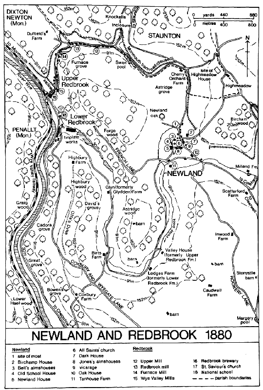
NEWLAND AND REDBROOK 1880
Many crossroads and junctions on the old roads seem to have been marked by wayside crosses in the Middle Ages. They included village crosses at Newland and Clearwell, (fn. 81) and, recorded in 1608, Crockets cross on French Lane west of Newland village, and Hodgeway cross, on Highmeadow way near the Staunton boundary. (fn. 82) There were perhaps once others at Wyegate Green, (fn. 83) and at the place called Blindway cross in 1685, where Coxbury and Wyegate Lane met a lane leading from farmsteads on Valley brook to Wyeseal on the Wye. (fn. 84)
The road on the northern boundary of the parish from Highmeadow down through Upper Redbrook hamlet was turnpiked in 1755, (fn. 85) and during the late 18th century and the early 19th it was part of the main Coleford to Monmouth route. (fn. 86) The road joining it at Cherry Orchard Farm, running from Coleford through Whitecliff, Millend, and Newland village, was turnpiked under the Forest of Dean trust established in 1796. The Forest trust also covered the road from Clearwell village towards Coleford, following the Forest boundary to Milkwall. (fn. 87) In 1827 the same trust was extended to include the Lydney to Newland village road between Bream Cross and Scatterford and also the ChepstowColeford road by way of Bearse common, Trow green, and Clay Lane End. (fn. 88) Under an Act of 1824 a new Wye Valley road from Chepstow to Monmouth was built, incorporating much of the old riverside route within the parish, and at the same time a branch from near the new Bigsweir bridge to the Forest, by way of Cockshoot Lane, Shop House, and Clay Lane End, was turnpiked. (fn. 89) In 1840 there were tollhouses at Trow green, Clay Lane End, Scatterford (later moved north-westwards to the junction with Rookery Lane), and above Upper Redbrook hamlet. (fn. 90) The upper Red brook valley road was disturnpiked in 1878, (fn. 91) the Wye Valley and Bigsweir roads in 1879, (fn. 92) and the roads of the Forest trust in 1888. (fn. 93) The ancient main routes on the steeper ground lost their importance in the turnpike era and most of them, including Highmeadow way, Coxbury and Wyegate Lane, and parts of Rookery Lane, remained narrow, unmade bridle paths in 1992. In the late 19th and early 20th centuries a ferry operated on the Wye at Lower Redbrook hamlet. (fn. 94)
The Monmouth tramroad, opened in 1812 to link the Forest mines and Monmouth, crossed the parish east of Newland village, where its course included a short tunnel below Bircham wood. In the upper Red brook valley it ran in Staunton and Dixton Newton (Mon.), over the boundary, but a branch, by means of an incline crossing the road and stream at Upper Redbrook hamlet, served wharfs on the Wye at Lower Redbrook. Only a modest traffic ran to Redbrook and the tramroad as a whole was little used after the mid 19th century when Monmouth was provided with a rail link to the South Wales coalfield. (fn. 95) In 1883 the Coleford railway to Monmouth was opened, using the old tramroad route, except for some short deviations, and serving Newland by a small station within Staunton parish near Cherry Orchard Farm. The railway was closed in 1916. The Wye Valley railway between Chepstow and Monmouth opened in 1876 and included a station at Upper Redbrook, where the line crossed from the Monmouthshire to the Gloucestershire bank of the Wye. The line was closed to passenger traffic in 1959 and to freight in 1964. (fn. 96) Remains from the railways and tramroad in 1992 included the cast iron bridge of the Wye Valley line across the river and the stone bridge of the tramroad incline across the road in Upper Redbrook.
Early settlement in the area took the form of scattered hamlets, often themselves of a dispersed nature but usually based on single streets running along the valleys. In Newland and Clearwell tithings a widespread pattern of settlement evident by the mid 14th century became less marked as a result of changes in the early modern period. The hamlets of Highmeadow and Ashridge, on the boundary with Staunton, (fn. 97) and the old settlement of Redbrook, on Valley brook between Newland village and the Wye, lost most of their houses, leaving only one or two large farmsteads. At Newland village, however, dispersed groups of dwellings were given a focus by new building around the church and churchyard, and at Clearwell a group of hamlets coalesced to form a substantial village.
At Newland village the parish church was built shortly before 1216 (fn. 98) on a low, flat-topped hill, sheltered by higher hills except to the south where the valley of Valley brook descends to the Wye. The top of the hill was presumably then unoccupied, giving scope for laying out the large rectangular churchyard, but the later disposition of the village suggests that there were already houses on the lower ground round about. They probably included a dwelling or dwellings near the source of the stream called Black brook on the Monmouth road north of the hill, and it was perhaps there that the name Welinton, used in the early 13th century for the area that the church was built to serve, (fn. 99) may have originated; the name is thought to mean a farmstead by a willow copse, (fn. 100) and there is an ancient moated site on Black brook on the west side of the Monmouth road. Other groups of houses that may be of early origin stood further down Black brook below and west of the hill and in the valley on the south side of the hill. The church and churchyard had attracted building around them by the mid 14th century. The church became the most significant point of reference in the large, dispersed parish: in the late Middle Ages and until the 17th century the village was known as Churchend, (fn. 101) and late-medieval property deeds when identifying roads converging on the place from other hamlets usually gave 'the church of All Saints' as the destination. (fn. 102) From the 17th century, however, the name Churchend was replaced by the name of the parish. The village was a minor market centre in the 15th and 16th centuries. (fn. 103) Later, as Coleford became established as the principal trading centre of the area, Newland village became residential in character, having a number of substantial gentry houses, two sets of almshouses, a grammar school, and in the mid 18th century a successful private school. (fn. 104) In the late 18th century the picturesque setting, the fine church in its well kept churchyard, and the several elegant houses gave it the reputation of one of the most attractive villages in the county. (fn. 105)
The church has remained the dominant feature of Newland village and the large churchyard its focus. (fn. 106) The main thoroughfare, on the LydneyMonmouth road, runs along the east side of the churchyard, and a village cross stood at the junction with the lane to Highmeadow in 1511 and 1608. (fn. 107) North of the churchyard two houses mentioned in 1404 as at Blackbrook Street (fn. 108) were presumably near the moated site by the Monmouth road. A house within the moat became the residence of the priest of Greyndour's chantry in Newland church in 1446, and it was demolished in the 18th century. (fn. 109) By the mid 14th century there were several houses on a lane running along the south side of the churchyard, (fn. 110) and that lane was probably the site of butchers' shambles in the 16th century; (fn. 111) from 1617 most of its south side was occupied by a row of almshouses built for the charity of William Jones. (fn. 112) The hillside south of the churchyard, formerly called Wolf hill, and the valley below had several houses in the 15th century. The lane there, leading from the Clearwell road towards Redbrook, was called Nether Churchend Street in 1472, but it appears also to have been called Warlows way at that period. Before it divides into French Lane and the valley lane at the south-west corner of the village, it is joined by a lane, known as Payns Lane in 1425 (fn. 113) and later Savage Hill, (fn. 114) descending steeply from the churchyard. In the early modern period the valley south of the village was the site of tanneries, (fn. 115) and in 1695 the road there was known as Barkhouse Lane from that trade, (fn. 116) but in the 20th century it was called Laundry Road. West of the hill three or four houses stood by Black brook, above its crossing by French Lane, in the early 17th century. (fn. 117) Their later disappearance was presumably the result of the incorporation of that area in the grounds and garden prospect of Newland House, built on the hill above.
The earliest surviving house in Newland village appears to be the Old School House, on the west side of the churchyard, formerly housing a grammar school founded by Edward Bell. Its earlier, north-south, range is apparently the building that was under construction for the school in 1576. (fn. 118) The southern end of that range was demolished in the early 20th century, (fn. 119) and the remaining portion is of a single storey with attic, having a large internal stack near the north end with a cross passage beyond it. There is some evidence that the range originally extended further north and was curtailed at the building of the east-west range, which is of two storeys and attics and is dated 1639. The plan of the later range, presumably designed specifically for the purposes of the school, provides heated rooms at each end, that to the east being larger, and two small, unheated rooms in the centre. All are joined by a passage, which is alongside the cross passage of the north-south range. Spout Farm, on the main street near the north end of the village, was recorded from 1669. (fn. 120) It is a small L-shaped rubblestone farmhouse of the mid 17th century, with an addition of c. 1800 at its south end.
Newland House, a substantial house at the south-west corner of the churchyard, was the home of the Probyns, who were the principal gentry family at Newland in the 18th century (fn. 121) and evidently did much to establish it as a popular residential village. A house in the main street east of the churchyard was rebuilt c. 1694 by William Probyn, whose family held it on long leases from Bell's charity. Before 1816 it became the Ostrich inn, (fn. 122) the sign derived from the Probyn crest. (fn. 123) The Dower House (formerly Dark House), in the same group of buildings, was apparently the house that Sir Edmund Probyn left to his sister Frances in 1742, with reversion to his nephew William Hopkins. (fn. 124) Later it belonged to Edmund Probyn (d. 1819) who left it to two daughters while they remained unmarried. (fn. 125) The main part of the house is of the early 18th century and of five bays with a hipped roof. About 1820 a room with a canted bay was added at the south-west and later in the 19th century two wings were added at the rear. Parts of an early 18th-century staircase survive, but the interior of the original house has been largely refitted.
On the hillside south-east of the village a house called Woofields, later Oak House, was leased in 1695 by George Bond of Redbrook to a carpenter who was to 'finish' the house; the carpenter sold the lease in 1700, and in 1712 the house was described as recently erected. (fn. 126) It was apparently owned or occupied by members of the Probyn family in the later 18th century (fn. 127) and in 1840 belonged to Edmund Probyn's daughter Susan Dighton, whose family lived there until the early 20th century. (fn. 128) In 1968 it became a home for mentally retarded people. (fn. 129) The central part of the north wing of Oak House has exceptionally thick walls retained from an earlier building, possibly a barn which stood at the site in 1665. (fn. 130) The new house of c. 1700 had a main block facing south-east and a recessed kitchen wing to the north-west. The entrance hall has fittings of high quality, and a square garden room has a venetian window and an elaborately coved ceiling. The room at the north-east end of the main front was redecorated in the early 19th century, and later that century a large first-floor drawing room was formed above the kitchen wing. During restoration after 1968 the service areas of the house were much altered and a new block was added at the rear.
Tanhouse Farm, on Valley brook at the southwest of the village, also dates from c. 1700, and is a four-square house with a front of five bays with timber mullion and transom windows. A small forecourt with pineapple and acorn finials surmounting its wall completes the symmetry of the design. The interior has been partly rearranged but retains a contemporary oak staircase. A branch of the Probyn family owned and worked a tannery there in the 18th century. (fn. 131) The Lecturage, at the east end of William Jones's almhouses and formerly the residence of the lecturer supported by that charity, (fn. 132) and South Lodge, on Savage Hill, are other fairly substantial early 18th-century houses. Birchamp House, in the north-east part of the village by the lane to Highmeadow, was built shortly before 1808, when it was called Newland Cottage. (fn. 133) Before 1820 it was improved and enlarged to form a substantial classical-style residence. (fn. 134)
Clearwell was probably settled rather later than Newland but eventually became a larger village. It developed on land which in the late 13th century was at the northern edge of the Forest waste of Bearse bailiwick, (fn. 135) and it formed around three roads which run down shallow valleys to a central junction. In the later Middle Ages the groups of houses on the three roads were apparently regarded as separate hamlets: those on the road running north-west towards Newland were distinguished as Clearwell (or Clearwell Street) and Wainlete, which as mentioned above was the old name of the crossroads at the road's north-west end, those on the road running east to Clearwell Meend and the extraparochial Forest as Peak, and those on the road running south towards Lydney as Platwell (or Platwell Street). (fn. 136) At the central junction a substantial cross on a high, stepped plinth was erected in the 14th century; it was restored and its missing finial replaced in the mid 19th century. (fn. 137) It was called the high cross in 1624 and the upper cross in 1705, (fn. 138) suggesting that a second village cross once stood at the Wainlete crossroads, which place was later known as Lower Cross. (fn. 139) The source of water which gave its name to the north-west street and ultimately to the whole village is a clear and copious spring emerging at the foot of the hillside a short way west of the cross and flowing along the northeast side of Clearwell Street as one of the main feeders of Valley brook. A pool at the spring was surrendered by a tenant to the lady of Clearwell in 1484, (fn. 140) and it was presumably the owners of the estate who enclosed the spring in a small stone wellhouse in the 19th century.
Clearwell Street and Platwell had dwellings by c. 1300, (fn. 141) and in 1349 there were 8 or more houses at Clearwell and 15 or more at Platwell and 'Platwell gate'. (fn. 142) In 1462 14 houses were mentioned at Clearwell and Wainlete, 13 at Platwell, and 16 at Peak. (fn. 143) In 1608 the northwest street and the east street, for which the name Peak remained in use until the 18th century, (fn. 144) were closely built up, with the main concentrations of houses around the central road junction and Wainlete. Platwell, more detached from the other settlements, was then a fairly compact hamlet. Later, a number of houses on the west side of the street at Platwell (fn. 145) were removed to make way for the kitchen gardens of the adjoining manor house called Clearwell Court, and by the early 19th century Platwell was a small, dispersed group of farmhouses and other dwellings. (fn. 146)
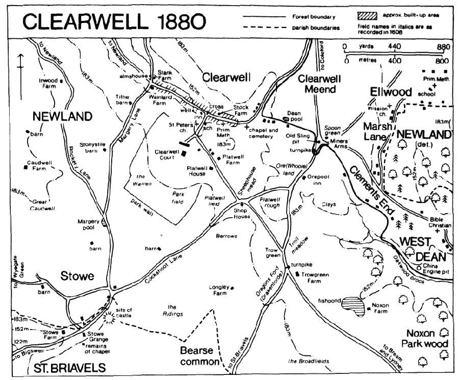
CLEARWELL 1880
Most of the houses that formed Clearwell village in 1608 were replaced by plain stone cottages in the late 18th century and the 19th, but several older farmhouses survive. At Stank Farm, north of Lower Cross, a small 17th-century house with a prominent central porch was extended to the north in the 19th century. The former Stock Farm (fn. 147) (in 1992 comprising Tudor Cottage and Tudor Farmhouse Hotel) in the east street is an L-shaped 17th-century house with an 18th-century wing added on the east. The Wyndham Arms, west of the central road junction, is a substantial 17th-century house, partly timber-framed, and there is an early 18th-century house north of the cross. On the east side of the street at Platwell a house called Baynhams incorporates a small 17th-century dwelling with a central gable and a west chimney stack, flanked by a staircase; it has walls of rubble but may have originally been timber-framed. The house was much altered in character in the early 20th century when Adeline Vereker (d. 1930), wife of the owner of Clearwell Court, enlarged it to the north and east and introduced many 17th- and 18th-century fittings, salvaged from other buildings. (fn. 148) Platwell Farm, further south, was owned with a freehold estate by the Skynn family during the 17th and earlier 18th centuries. (fn. 149) A substantial new farmhouse was built in the mid 19th century; its predecessor stood further south (fn. 150) where a farm building incorporates 17th-century windows. Platwell House, on the west side of the road, was owned from the late 17th century to the mid 19th by the Hoskins family, landowners in Newland and St. Briavels. (fn. 151) A low service wing on the northwest has heavy floor joists of 16th-century character. The principal range, to which it adjoins, is in part timber-framed and may survive from an L-shaped house which was rebuilt in stone and enlarged in the 17th century. In the mid or late 18th century a staircase was built in the entrant angle and the west front remodelled with a central doorway and an ogee-headed first-floor window. The interior retains fittings of c. 1700 and of the late 18th century.
In 1830 a chapel of ease was built for Clearwell village at the east end, on the road leading to the Forest. It was replaced in 1866 by a new church built by the countess of Dunraven, owner of the Clearwell estate, near the entrance to Clearwell Court in part of Platwell Street; that part of the street became known as Church Street. The countess had built a village school on the street in 1859, (fn. 152) and a few estate cottages were added in the same part of the village later in the century. Although containing the residence of the owners of a large landed estate, Clearwell in the 19th and early 20th centuries was inhabited mainly by small freeholders, often engaged in village crafts or mining and quarrying. (fn. 153) In 1907 only 9 cottages in the village belonged to the estate, together with three farmhouses, the Wyndham Arms, and a substantial house built opposite the grounds of Clearwell Court in the mid 19th century as the residence of the estate bailiff. (fn. 154) West Dean rural district built five pairs of council houses on the Newland road beyond Lower Cross in the 1930s (fn. 155) and a terrace of houses just south-east of Lower Cross, replacing the farmhouse of Wainland Farm, in 1957. (fn. 156) In the mid and late 20th century the north-west street was further altered by new private houses, some of them replacing older buildings. Clearwell was a fairly populous residential village in 1992, when it included two hotels, at the former manor house and the Wyndham Arms, two other public houses, and a post office and shop.
Redbrook, as a settlement name, has been used loosely over the centuries to cover the whole area traversed by the two brooks that descend to the river Wye. Its main use was originally for a scattered settlement in the valley of Valley brook between Newland village and the river. That settlement was referred to as Redbrook Street in 1352 (fn. 157) and as Over Redbrook in 1596, (fn. 158) and its two principal farmsteads were called Upper and Lower Redbrook Farms until the early 19th century. (fn. 159) A hamlet that formed beside the Wye at the foot of Valley brook was usually identified as Wye's Green before the 18th century, (fn. 160) and a group of mills near the foot of the northern valley, though sometimes said to be 'at Redbrook', was more usually identified as 'in Ashridge Slade' in the 15th and 16th centuries. (fn. 161) The names Lower and Upper Redbrook for the two riverside hamlets became established only in the later 18th century. (fn. 162)
The settlement called Redbrook Street in 1352 probably comprised several groups of dwellings at intervals along Valley brook. In 1608 there were houses at the sites of Upper and Lower Redbrook Farms on the left bank of the stream c. 1.5 km. below Newland village and three or four dwellings on the opposite bank close by. Downstream, where the valley road was joined by the lane from Blindway cross near the site of the later Birts Farm, stood another small group, and another group of about four houses stood further downstream, above the site of the later Glyn Farm. (fn. 163) Most of the smaller houses were demolished when large parts of the valley were absorbed into a single estate based on Upper Redbrook Farm, but two new farmhouses were built in the lower part of the valley. Birts Farm was evidently the house and farm buildings that were under construction on land called Birts bought by George Bond of Upper Redbrook Farm in 1642, (fn. 164) and Glyn (formerly Glydden or Clidden) Farm was built before 1800. (fn. 165) In 1992 the small stone house at Birts Farm, no longer a farmhouse, had recently been heavily restored, while Glyn Farm was used as a pony trekking centre. Highbury Farm, high above the stream at the lower end of the valley, was recorded from 1696, (fn. 166) and the low, stone farmhouse may date from the 17th century. About 1800, (fn. 167) however, a castellated Gothick facade was attached to its northern end, and it was known as Highbury Cottage in the early 19th century when successive owners were men from London, Wolverhampton, and Norfolk, presumably attracted there by the vogue for Wye Valley scenery at that period. (fn. 168)
The riverside hamlets called Upper and Lower Redbrook were industrial in origin, having a number of mills by the end of the Middle Ages and a variety of industries later. (fn. 169) Their character, as it survived in 1992, was mainly set by building in the dark Forest sandstone during the 19th century, when the Monmouth tramroad of 1812, the Wye Valley turnpike road of 1824, and the Wye Valley railway of 1876 aided industrial growth. Upper Redbrook is a straggling settlement in the deep valley of the upper Red brook, originally based on a series of mills. The buildings stand beside the brook and the Newland-Monmouth road, some within Newland and some within Dixton Newton parish (Mon.). By about 1830 a long terrace of 18 workmen's tenements had been built near the foot of the valley. (fn. 170) Later in the century more cottages and some larger houses, built for millers and other industrialists, were added in the valley, and the terrace was replaced or remodelled c. 1900 as eight dwellings. Lower Redbrook formed a more compact settlement at the foot of Valley brook. Six cottages had been built by 1712 on the land called Wye's Green below a copper works which had been established there. (fn. 171) In 1827 the large tinplate works, which had replaced the copper works, owned 18 workmen's cottages, (fn. 172) most of them on the turnpike road, facing the river. A larger house of c. 1700, once occupied by the manager of the works, (fn. 173) was demolished in the late 20th century. (fn. 174) A chapel of ease and a school were built in 1872 (fn. 175) on the main road north of Lower Redbrook, and a group of council houses built north of them between 1930 and 1934 (fn. 176) linked the two Redbrook hamlets. In 1939 the Highbury estate of 24 council houses was built on the hillside south of Valley brook at Lower Redbrook. (fn. 177)
South of the Redbrook hamlets, on the narrow strip of meadowland that borders the Wye below its wooded hillsides, the only early dwelling recorded was the house called Wyeseal, established by the mid 13th century near the boundary with St. Briavels. (fn. 178)
The smaller settlements in Newland and Clearwell tithings included Stowe on the south boundary where the old road between Newland village and St. Briavels, the road from Bigsweir to the Forest, and other lanes converged. The hamlet was sometimes called Stowe Green from a substantial green that lay south of the Bigsweir road, partly in St. Briavels parish. (fn. 179) It was encroached on and quarried away during the 19th and 20th centuries. (fn. 180) There was at least one dwelling at Stowe by c. 1300 (fn. 181) and there were several in the 15th century. (fn. 182) In 1608, apart from Stowe Grange and Stowe Farm, which are in St. Briavels parish, there were seven houses dispersed on the various lanes. One small farmhouse, straddling the boundary where a lane from Wyegate joined the Bigsweir-Forest road, (fn. 183) was known as the 'two parish house' in 1653. (fn. 184) The older houses within Newland were all removed before the mid 19th century except for two, and those, known later as Stowe Hall and Stowegreen Farm, (fn. 185) were rebuilt. A few new cottages added for limeburners and farm labourers gave the hamlet a population of 8 households in 1851. (fn. 186)
Wyegate Green, on the south boundary high above the Mork valley, was apparently the site of an Anglo-Saxon settlement that was added to the Forest waste in the late 11th century. (fn. 187) In 1608 three houses stood on the west side of the narrow green which lay on the ancient lane from St. Briavels to Lower Redbrook hamlet. (fn. 188) In 1851 there were a few farm labourers' cottages at Wyegate Green, (fn. 189) and two survived, recently restored, in 1992.
At Millend, between Newland and Clearwell villages, a small, dispersed hamlet, containing five or more houses in 1462, (fn. 190) formed around mills on the upper part of Valley brook. A small former farmhouse on the east side of the road leading to Whitecliff dates in part from the 17th century and there are two substantial late 19th-century houses on the road. In 1478 a house was recorded at or near the site of Scatterford Farm, at the junction of that road and the Lydney-Monmouth road. Originally the centre of a small freehold farm, (fn. 191) in the 1720s Scatterford became part of an estate that was acquired in Newland by the Symons family. (fn. 192) The house has an irregular, double-pile plan with a broad central corridor. Its plan developed from additions made to an earlier house in the 17th century, but its character in 1992 owed much to a recent restoration. The western corner of the building is of medieval origin and has a later inserted ceiling, divided into six compartments by moulded beams, and a large fireplace with a formerly external doorway beside it. It formed the south-west end of a range which was probably shortened in the 17th century, when the house was enlarged by an addition to the south-east and given a new entrance range facing north-east. The use of quarter-round, chamfered ceiling beams throughout suggests that the enlargement took place over a relatively short period. The new entrance range had a twostoreyed central porch but with an asymmetrical arrangement of windows and chimneys, perhaps because it was partly re-using an earlier building. Many alterations, including the removal of the porch, were made during the 18th and 19th centuries, and an extensive restoration, with some additions, was carried out after 1986. (fn. 193)
In 1608 a few dwellings, later demolished or rebuilt, stood on a lane that climbed over the south end of Clearwell Meend at the parish boundary, some of them just above Clearwell village and others at the east end of the lane, near Spoon green. (fn. 194) Some labourers' cottages and a farmhouse were built in the early 19th century on that lane near a pond called Dean pool. (fn. 195) Lambsquay, on the parish boundary near the north end of Clearwell Meend, had some dwellings by 1465. (fn. 196) About 1800 a substantial house was built there beside the Chepstow-Coleford road. (fn. 197) In the late 19th century it was occupied by Edwin Payne (d. 1897), a stone merchant, (fn. 198) and in 1992 it was a hotel.
The farmsteads of the high, open land in the south of the main part of Newland parish were established as, or else became, tenant farms to the main estates and were built or rebuilt of stone in the plain vernacular style of the 18th and early 19th centuries. The area is also dotted with large stone barns. Farmhouses were recorded from the 16th century at Inwood (fn. 199) on Rookery Lane, at Caudwell (fn. 200) above the Valley brook valley, and at Coxbury (fn. 201) high above the Wye Valley where the track between Valley brook and Wyeseal crossed Offa's Dyke. A small farmhouse at Shop House at a road junction south of Clearwell village took its name from a sheephouse belonging to the Clearwell estate. (fn. 202) Of the principal farmhouses of the Clearwell estate in the south-east part of the parish, Trowgreen and Longley (formerly Longney) may not have been established until the 18th century, (fn. 203) but Noxon dates in part from the 17th century. (fn. 204) The name of Stonystile barn, on Margery Lane, west of Clearwell, was recorded as that of a field in 1505, (fn. 205) and may derive from the stone-slab stile in a wall there. A new farmhouse and barn were built at Stonystile c. 1721 (fn. 206) but in 1992 a 20th-century house adjoined older farm buildings. Tithe barn, on the same lane nearer Clearwell village, belonged to the Newland rectory estate. (fn. 207) In the mid and late 20th century some of the big, isolated barns had new houses built beside them or were themselves converted as dwellings.
Bream village, in the largest of the detached portions of Newland parish, had five or more dwellings by 1462. (fn. 208) A chapel of ease was built there before 1505, (fn. 209) probably as much because of the distance from the parish church as because of the number of inhabitants. In 1608 the village remained small, with houses spaced loosely along the Lydney-Newland road in a low valley and with some others in the entrance to a road that branched northwards to Parkend in the extraparochial Forest. (fn. 210) In an undated record of the late 17th century it was said that only c. 24 families then lived in Bream tithing, (fn. 211) a description which may also have included the two detached portions at Yorkley. The earliest surviving house at Bream village, standing near the entrance to the Parkend road, is dated 1637 with initials which are probably for George Gough, a Bristol man who was buying land in the area in the 1620s. (fn. 212) It is an early 17th-century house on an L plan, with a contemporary porch at the south-east of the main, east-west, range. That range probably once extended further east where a 19th-century building now stands. The house, which was the New Inn during the 19th and early 20th centuries, was restored in the 1980s. (fn. 213) Bream Court Farm, near the west end of the main street, is a small rubble-built farmhouse of the late 17th century.
The other houses at Bream are mainly cottages built in the mid and later 19th century when the village became part of a larger settlement, which included the area called Bream's Eaves on extraparochial land to the north, and took on the character of the other mining hamlets of the Forest fringes. Its chapel was rebuilt as the centre of a new ecclesiastical parish and the whole settlement was served by a school and by nonconformist chapels over the Forest boundary. (fn. 214) Until the beginning of the 20th century the junction of the old village street and the Parkend road remained a focal point of village life but by the middle of the century, when two public houses there closed and some shops were demolished, the centre of gravity had shifted to High Street on the part of the Parkend road within the formerly extraparochial land. (fn. 215) A small estate of private houses was built in the old village, east of the road junction, in the 1980s.
The principal early farmhouse of the Bream area was at Pastor's Hill east of the old village, (fn. 216) and a farmhouse was recorded from 1578 at Brockhollands, further south near the Lydney boundary. (fn. 217) From the late 18th century cottages were built in the north-east of the parochial land of Bream, later forming part of the Forest hamlets of Whitecroft and Pillowell. (fn. 218)
The detached parts of Newland at Yorkley, divided by the road running north from Lydney to Yorkley village, probably had dwellings by the early 14th century. Seven cottages mentioned on Lord Berkeley's manor of Yorkley in 1346 may, however, have been in Lydney parish, from which the manor received rents. (fn. 219) In the early modern period the parts of Newland at Yorkley appear to have contained only two farmhouses, Yorkley Court (fn. 220) in the west part and Badhamsfield in the east part. Badhamsfield, as mentioned above, probably derives its name from medieval ownership by the ap Adam family and the farmhouse was recorded by that name in 1626, (fn. 221) but the surviving house is no earlier than the late 18th century and was heavily restored in the mid 20th. By 1775 c. 10 cottages had been built on parish land at the north-west boundary of Yorkley Court farm (fn. 222) as part of the developing village of Yorkley. In the mid 19th century land within the parish was colonized by a larger group of cottages called Yorkley Wood. (fn. 223)
In Whitemead park, an island of the parish within the extraparochial Forest, a farmhouse had been built by 1651, when there were also eight small cottages there. (fn. 224) The cottages, some of them occupied by people working an iron furnace at Parkend, were presented as illegal encroachments in 1656 and were probably demolished soon afterwards. In the early 18th century the park contained only a farmhouse at its north boundary (fn. 225) and a second farmhouse was built in the east part shortly before 1751 when the park became two farms, divided by Cannop brook. (fn. 226) Early in the 19th century, when most of the park was included in a new timber plantation, the eastern farmhouse was demolished and the northern one adapted as the residence of the Forest's deputy surveyor. (fn. 227)
The island of Newland at Ellwood contained a number of houses by 1608. (fn. 228) A farmhouse on the north boundary, later called Ellwood Farm, belonged to the Symons family's estate in the 18th century, (fn. 229) and another farmhouse belonged then to the Newland House estate. (fn. 230) From c. 1819, when the Crown planted most of the farmland of the parochial land at Ellwood, a farmhouse at the south-east corner, adjoining the Forest hamlet of Little Drybrook, became a woodman's lodge (fn. 231) called Ellwood Lodge. From the 1860s, however, it was leased as a private house (fn. 232) and the Forestry Commission sold it in 1968. (fn. 233) The older part of Ellwood Lodge is a small late 17th-century house with a tworoomed plan and a large gable-end stack. It was extended in the late 18th century by the addition of a short wing in front of its west end and in the early 19th century by a block beyond the eastern gable. In the mid 19th century the west end was remodelled: the floor levels were raised and the roof of the old house was reconstructed. In the north part of the parochial land at Ellwood a number of cottages were built near Ellwood Farm in the mid 19th century to form, with other cottages beyond the boundary, the hamlet of Ellwood. (fn. 234)
In 1327 18 people, a small proportion of what was probably already a substantial population, were assessed for the subsidy in Newland parish. (fn. 235) In 1349 78 houses were listed at Clearwell, Coleford, and Whitecliff alone and the list was probably not comprehensive for those areas. (fn. 236) The parish was said to have c. 700 communicants in 1551, (fn. 237) 250 households in 1563, (fn. 238) 850 communicants in 1603, (fn. 239) and 300 families in 1650. (fn. 240) About 1710 the population was estimated at c. 2,200 living in 480 houses, 160 of the houses said to be in Coleford tithing, (fn. 241) and c. 1775 the population was estimated at c. 2,997. (fn. 242) In 1811 in the three tithings covered in this parish history - Newland, Clearwell (including the detached part at Ellwood), and Bream (including the detached parts at Yorkley) - there was a total of 1,524 people; Coleford tithing then had 1,551 and Lea Bailey tithing 72. (fn. 243) In Newland, Clearwell, and Bream tithings the population was 1,745 by 1831 and 2,316 in 1861, most of the increase occurring in Bream tithing with the growth of the mining hamlets of the area. In 1901 the population of Newland civil parish was 1,877, rising to 2,061 by 1931. In 1951, after the loss of the parts at Bream and Yorkley, the population of the civil parish was 1,148, declining to 877 by 1971 and rising again to 924 by 1991. (fn. 244)
In 1600 Newland parish contained eight or more victualling houses, presumably scattered through its constituent villages, including Coleford. (fn. 245) The Ram inn where the parish vestry met in 1754 and 1765 was presumably in Newland village. (fn. 246) The Ostrich, open by 1816, (fn. 247) was the only public house there in modern times. A former smithy at the north end of the village became the village meeting room c. 1920, (fn. 248) given by the Roscoe family of Birch-amp House as a memorial to the war dead. (fn. 249)
In Clearwell village an inn or lodging house (hospitium) that was granted on lease in 1518 with the consent of the parishioners of Newland may have been used as a church house. (fn. 250) The village had the Carpenters Arms inn by 1787, the Butchers Arms by 1802, (fn. 251) and the Wyndham Arms, named from the family at Clearwell Court, by 1821. (fn. 252) In 1906 its public houses were the Wyndham Arms, the Butchers Arms, the Lamb, and at least one beerhouse, (fn. 253) and in 1992 the Wyndham Arms at the central road junction, by then enlarged as a substantial hotel, and the Butchers Arms in the east street and the Lamb in the west street remained open. A friendly society had been formed in Clearwell village by 1787. (fn. 254) A cottage hospital was opened by the countess of Dunraven in 1869. (fn. 255) A recreation ground was laid out at the west end of the village before 1934, and during the late 1930s Col. Charles Vereker of Clearwell Court organized unemployed men in building an open-air swimming pool. (fn. 256)
At Orepool on the Chepstow-Coleford road near the east boundary of the parish an inn had opened by 1851 and remained open as the Orepool inn in 1992. The hamlet of Stowe had a beerhouse in 1851, (fn. 257) probably the Travellers Rest, which was so called by 1891 (fn. 258) and was still open in 1992.
Upper Redbrook hamlet had three public houses by 1856: the Bush was at the bottom of the hamlet near the river, just within Dixton Newton, and the Queen's Head and the Founders Arms were further up the hill. (fn. 259) Only the Bush remained open in 1992. At Lower Redbrook the King's Head and the Bell had opened by 1848 among the cottages below the tinplate works. (fn. 260) The King's Head closed in the mid 20th century (fn. 261) and the Bell remained in 1992 (but closed and awaiting a new tenant). About 1887 the Redbrook Tinplate Co. built its workers an institute, including a meeting room and billiard room, on the north side of the works, adjoining the National school. In 1955 the company transferred the building to the parochial church council for use as a village hall. From c. 1963 it was run by the Redbrook community association, which also managed a recreation ground (fn. 262) that had been opened before 1920 at the riverside. (fn. 263)
By 1792 the Cross Keys inn had opened in Bream village at a house on the west side of the road leading into the Forest, and by 1814 the New Inn had opened in an early 17th-century house on the opposite side of the road. (fn. 264) Both closed in the mid 20th century, the sign of the Cross Keys being transferred to a public house in Bream's Eaves beyond the former parish boundary. (fn. 265) In 1864 a village wake was held in Whit week, at which the villagers competed in games for prizes strung on a rope across the roadway between the two inns. The wake later lapsed and was briefly revived in the 1920s. Until c. 1926 a maypole stood near the inns at the junction of the old village street and the Forest road. (fn. 266)
MANORS AND OTHER ESTATES.
Although the parish of Newland was formed by assarting after the Norman Conquest, it included one or more earlier estates that had been returned to or had reverted to the Forest woodland and waste. A six-hide manor called WYEGATE (Wigheiete) in Lydney hundred was held in Edward the Confessor's reign by Aleston and after the Conquest by Ralph de Limesi and William de Eu in succession. Before 1086, however, on William I's order it was included in the Forest. That evidently involved removing the population and taking the land out of cultivation, not merely the imposition of Forest law: Wyegate was valued at 60s. in 1066 but in 1086 a fishery worth 10s. was the only asset recorded. (fn. 267) The manor was presumably centred on Wyegate Green, at the south boundary of the later parish, with its lands on the high ground to the north and east and, perhaps, in the Mork brook valley in the later St. Briavels parish. Land in the area was being returned to cultivation by 1338, when licence to assart lands at Wyegate was granted to Grace Dieu abbey (Mon.), the owner of Stowe manor in St. Briavels; (fn. 268) in 1608 Stowe manor included c. 80 a. lying east of Wyegate Green. (fn. 269) 'Brocote', where two manors formed part of the Herefordshire hundred of Bromsash and which Domesday Book appears to place near Staunton, has been identified speculatively as Redbrook. The manors at Brocote had already become waste by 1066 and were described as within the Forest ('the king's wood') in 1086. (fn. 270)
As land was cleared and settled during the 12th and 13th centuries a royal manor of NEWLAND was established. In the early modern period it comprised only the chief rents and heriots charged on the principal estates of the parish, such as Clearwell, Breckness Court (in Coleford tithing), Wyeseal, and Upper and Lower Redbrook farms, and on cottages and small holdings in Lea Bailey tithing; Whitemead park was the only part of the parish that the Crown is recorded as holding as demesne. (fn. 271) Newland manor formed part of a royal estate, including also St. Briavels castle and manor and the profits of the Forest, that was farmed by the constables of St. Briavels in the 13th and 14th centuries (fn. 272) and was later held on lease under the Crown. (fn. 273)
WHITEMEAD PARK, the detached part of the parish near Parkend, was presumably inclosed from the Forest by the Crown itself. Land called the meadow of Whitemead was held by the constable of St. Briavels in 1283, (fn. 274) and Whitemead was termed a park in 1435 when the duke of Bedford held it as part of his St. Bnavels castle estate. (fn. 275) The Crown appointed keepers of the park between 1464 and 1502, (fn. 276) and it may not again have been attached to the St. Briavels estate until the early 17th century. Sir Richard Catchmay held it as sub-lessee of the earls of Pembroke in 1627 and 1638, (fn. 277) and it was included in a renewal of the lease to the 4th earl in 1640. (fn. 278) Before 1653 it was taken in hand by the Commonwealth government which then sold it. The sale was opposed by local inhabitants, who claimed that Whitemead had never been imparked but was simply an inclosure made for use by the Crown and its lessees as a cattle pound for the Forest. (fn. 279) The sale was not recognized at the Restoration and in 1662 the Crown leased Whitemead to Henry, Lord Herbert, (fn. 280) later duke of Beaufort, and it then passed once more with the St. Briavels castle estate. After 1688, however, the duke's declining influence encouraged local inhabitants to challenge once more its status as a park (fn. 281) and mobs of commoners repeatedly broke its fences, so that the duke received no profit from it for c. 10 years. (fn. 282) During the 18th century tenants farmed the park under the Crown lessees, its c. 230 a. being divided into two farms after 1751. (fn. 283) In 1807 the lessee, the earl of Berkeley, surrendered it to the Crown, and in 1808, at the start of the programme of replanting the Forest, all but a few acres around Whitemead Park house at the the north-west corner were included in new plantations. (fn. 284) Whitemead Park house probably occupied the site of the farmhouse built in the park by an under-tenant before 1651, (fn. 285) and in the 18th century the farmhouse of the Barrow family, the principal under-tenants, was there. (fn. 286) In 1816 the house became the official residence of the deputy surveyor of the Forest, Edward Machen, (fn. 287) whose successors lived there until 1968. (fn. 288) In the mid 20th century it was also the local headquarters of the Forestry Commission, an office block being added in 1960. The house, which was rebuilt or extensively remodelled in the years 1810 and 1811, was sold with its grounds in 1970 to the Civil Service Motoring Association, (fn. 289) which demolished the house and established a clubhouse, camping ground, and caravan park for the use of its members; later a number of wooden holiday chalets was built.
In the Middle Ages the principal inhabitants of Newland were members of the Joce family and their successors, who in the 14th and 15th centuries received chief rents from several hundred houses and plots of land in Newland village, Clearwell, Coleford, Whitecliff, Highmeadow, Bream, Mork, and other places in Newland and St. Briavels parishes. (fn. 290) Presumably the Joces had obtained a general grant from the Crown of new assarts or the rents from them in a wide area. The chief rents had effectively lapsed by 1868 when an attempt was made to levy some of them in St. Briavels. (fn. 291) The Joces and their successors also held the woodwardship of Bearse bailiwick, (fn. 292) which covered much of the area from which Newland and St. Briavels parishes were formed. The woodwardship was later thought to be attached to Clearwell, (fn. 293) the demesne estate of the holders, but a reference to William Joce as forester 'of St. Briavels' c. 1245 (fn. 294) suggests that the bailiwick, too, originated in a wider grant of rights in the Newland and St. Briavels area.
Richard son of Joce, who was listed as one of the woodwards of Dean in 1223, (fn. 295) was presumably an early holder of Bearse bailiwick and the rights in assarted lands. William Joce, as mentioned above, was a forester c. 1245, and William Joce, also called William the woodward, held Bearse bailiwick in 1282. (fn. 296) He or another William gave lands in Newland to his son Philip in 1320, (fn. 297) and in 1338 John Joce, probably son and heir of Philip, (fn. 298) had licence to assart lands in Newland and St. Briavels. (fn. 299) John was claiming manorial rights in Newland in 1338, (fn. 300) and in 1349 he was receiving the chief rents mentioned above. (fn. 301) John Joce the elder and John Joce the younger were mentioned in 1365, (fn. 302) and the younger was presumably the man who with his wife Isabel made a settlement of a large estate in Newland and adjoining parishes in 1378. (fn. 303) John died before 1389, (fn. 304) and before 1395 Isabel married John Greyndour, (fn. 305) who died in 1415 or 1416. (fn. 306) Greyndour evidently secured an unrestricted title to his wife's estate, which from the early 15th century was known as the manor of CLEARWELL, the chief residence and most of the demesne lands being by then situated in Clearwell tithing. John was succeeded by Robert Greyndour, his son by his first wife Marion. (fn. 307) Robert Greyndour (d. 1443) was jointly enfeoffed of the estate with his wife Joan, (fn. 308) who married before 1455 (fn. 309) John Barre. John died in 1483 (fn. 310) and Joan in 1484, when the Clearwell estate passed to Robert's heir Alice, the wife of Thomas Baynham (fn. 311) (d. 1500) (fn. 312) and later of Sir Walter Dennis (d. 1505 or 1506). Alice (d. 1518) was succeeded by her son Sir Christopher Baynham, (fn. 313) and Sir Christopher was succeeded in the estate, apparently in his lifetime, by his son George Baynham. (fn. 314) George, who was knighted in 1546 and died that year, (fn. 315) left the estate to his son Christopher, who was a minor in the king's custody in 1548. (fn. 316) From Christopher (fl. 1555) (fn. 317) it passed, probably by 1558, (fn. 318) to his brother Richard (d. 1580), who was succeeded by another brother Thomas (fn. 319) (d. 1611). (fn. 320) Thomas Baynham settled his estates in Newland and the adjoining parishes on his elder daughter Cecily, wife of Sir William Throckmorton, Bt., while his younger daughter Joan, wife of John Vaughan, received estates that he owned elsewhere in the Forest area. (fn. 321)
Sir William Throckmorton (d. 1628) was succeeded in the Clearwell estate by his son Sir Baynham (d. 1664) (fn. 322) who paid a large fine to recover his estate from sequestration after the Civil War but forfeited it again later, buying it back in 1653. Before his death Sir Baynham apparently made the estate over to his son and heir, and the son, also Sir Baynham, was still in debt in 1672 as a result of the recovery of the estate. (fn. 323) The younger Sir Baynham Throckmorton died c. 1680, having provided for his estate to be sold for the benefit of his wife Catherine and his daughters. In 1684 James Stephens agreed to purchase the estate but died before completion, and in 1698 Catherine, her daughter Catherine Wild, her stepdaughter Carolina Scrymsher, and Stephens's widow Barbara sold Clearwell to Francis Wyndham. (fn. 324) From Francis Wyndham (d. 1716) the estate passed in the direct male line to John (d. 1725), Thomas (d. 1752), (fn. 325) and Charles. Charles Wyndham inherited the Glamorganshire estates of Dunraven Castle and Llanvihangel, and under the will of the uncle who left him the latter he took the surname Edwin. He died in 1801, when he was succeeded by his son Thomas Wyndham (d. 1814). Thomas was succeeded by his daughter Caroline, wife of Windham Henry Quin of Adare (co. Limerick), who took the additional surname Wyndham. W. H. Wyndham Quin, who had the courtesy title of Viscount Adare from 1822 and succeeded to the earldom of Dunraven and Mount-Earl in 1824, died in 1850; Caroline, countess of Dunraven, retained Clearwell until her death in 1870. (fn. 326) Under family trusts the estate passed before 1876 to the countess's grandson Windham Henry Wyndham Quin, who with the trustees conveyed it c. 1882 to John Eveleigh Wyndham (fn. 327) (d. 1887). (fn. 328)
In 1893 the Wyndham trustees sold the estate to Henry Collins, whose mortgagees later secured possession (fn. 329) and in 1907 offered the estate for sale. It then comprised Clearwell Court and 14 farms in Newland and St. Briavels, a total of 2,300 a. (fn. 330) A large portion, comprising Noxon and Trowgreen farms and Noxon Park wood, was sold in 1907 to the Crown Commissioners of Woods, and a larger portion to Col. Alan Gardner, the tenant of Clearwell Court. Gardner died a few days after completing the purchase and his executors sold his estate in 1910 to James Lewis. Lewis sold the farms in 1912 to the Commissioners of Woods, (fn. 331) having sold the house and its park the previous year to Charles Vereker, later Col. Vereker, who died in 1947. (fn. 332) In 1992 the Crown's Clearwell estate covered 487 ha. (1,203 a.), formed of Noxon, Longley, Platwell, and Wainland farms in Newland and Bearse farm in St. Briavels. (fn. 333)
Philip Joce had a house at Clearwell in 1324 (fn. 334) but John Greyndour had a house in Newland village in 1414, (fn. 335) and the owners of the estate may not have been consistently resident at Clearwell until the time of Robert Greyndour, the first to be styled of Clearwell rather than of Newland. (fn. 336) In 1443 Robert's house at Clearwell comprised hall, chapel, 12 chambers, buttery, pantry, and cellar, besides farm buildings. (fn. 337) It was presumably at the site of Clearwell Court, south-west of the village, which remained the principal residence of the owners of the estate until the early 19th century when the Wyndhams lived also at Adare and Dunraven. (fn. 338) Clearwell Court had 21 hearths in 1672, (fn. 339) and c. 1710 was a rambling structure, presenting a long multigabled front to the west. It was mainly of the 17th century but probably of several different builds within that period. (fn. 340) It was rebuilt by Thomas Wyndham c. 1728 from designs by Roger Morris (fn. 341) as a large mansion in castellated Gothick style. Initially it was of few rooms, with a two-storeyed centre recessed between short three-storeyed wings, all on a high basement. The windows of the principal floor have twocentred heads with simple Y tracery above mullions and transoms, those of the first floor having square heads within mullions and transoms and all having hood mouldings. At the outer angles there are diagonal buttresses, and the roof is hidden by an embattled parapet bearing the Wyndham crest. In the mid 18th century additions, including a long axiallyplaced library, were made at the rear of the house. It is not known how the interior was fitted: a number of surviving fireplaces in early 18th-century style have been attributed both to Morris and to the mid 19th century when the interior was altered for the countess of Dunraven by John Middleton. (fn. 342) North-east of the house, a stable range with a central carriageway and a screen wall and road gate are probably by Morris, but the east end of the stables appears to incorporate part of the 17th-century stables, and the lodges at each end of the screen wall are 19th-century additions. The terracing of the gardens is probably contemporary with the mid 19th-century refurbishment of the house. The house, which was usually called Clearwell Castle in the 20th century, was gutted by fire in 1929 and was repaired by Col. Vereker. After his death in 1947 it was left empty for some years, and fittings were removed and the fabric badly damaged by vandals. In 1952 the house was bought by Frank Yeates, (fn. 343) son of a former gardener on the estate, who spent many years restoring the house, the work being done by himself and members of his family. The Yeates family sold the house in the early 1980s, when it became a hotel. (fn. 344)
An estate called NOXON in the south-east part of Clearwell tithing was established in 1317 when the Crown granted John of Wyesham, then constable of St. Briavels, (fn. 345) a fishpond and licence to assart 200 a. of Forest waste adjoining it. John took in 280 a. but the additional land was confirmed to him in 1321. (fn. 346) He died c. 1332, leaving as his heir a son John, (fn. 347) during whose minority Noxon was placed in the custody of Gilbert Talbot. (fn. 348) By the end of the 14th century Noxon had passed to William Wyesham, who leased it to Isabel, widow of John Joce, and in 1403 conveyed it in perpetuity to her and her second husband John Greyndour. (fn. 349) It then descended with the Clearwell estate, passing to the Crown in 1907. (fn. 350) There were farm buildings at Noxon in 1443, (fn. 351) but in the 16th and early 17th centuries most of the land was used as a park and in 1611 it had two lodges, a new one and an old one. (fn. 352) Later the south-western side of the estate, adjoining the Lydney-Coleford road, was a tenant farm while the north-east side, chiefly comprising Noxon Park wood, was maintained as woodland and mined for iron ore. (fn. 353) Noxon Farm may occupy the site of one of the lodges, though the surviving house dates from the late 17th century. Its main range was probably built in two stages at that period, with the west end the earlier. During the 19th century the range was much altered and additions were made to its south side in three or more stages. The fishpond at Noxon in 1317 was probably on Oakwood brook on the north-east boundary; (fn. 354) a large pond that adjoins the farmhouse appears to have been made later, before 1840. (fn. 355)
A small manor called WYESEAL belonged to the bishop of Hereford in the early 13th century when it comprised a house called the Grange and lands extending along the Wye from Redbrook to the St. Briavels boundary. The narrow strip of riverside lands that later were tithe-free or tithable to the owner (fn. 356) evidently represented the original estate, and the house was presumably at the site of Wyeseal Farm. Successive tenants under the bishop were John of Newland and William, a priest, and in 1253 the bishop granted the estate in fee to Gay, a servant of William. It apparently passed to its later owners, the Bond family, through the marriage of Ellen, daughter of Thomas Gay. (fn. 357) Thomas Bond of Wyeseal was recorded in 1430, (fn. 358) and the same or another Thomas in 1462. (fn. 359) John Bond (d. by 1533) was succeeded at Wyeseal by his son George, (fn. 360) and John Bond owned Wyeseal manor in the 1580s (fn. 361) and was succeeded by his son Thomas. Thomas conveyed the estate in 1609 to William Catchmay (d. 1636), who devised a third of Wyeseal to his wife Tacy and the rest to his second son John. (fn. 362) Tacy leased her share in 1639 to George Bond of Redbrook, (fn. 363) and he or his heirs later acquired the freehold of the whole manor. Wyeseal then descended with Upper Redbrook farm (fn. 364) until 1800 when Lord Sherborne sold the estate, then c. 120 a., to the Revd. John Powell of Monmouth. (fn. 365) By 1840 it belonged to the Bigsweir estate in St. Briavels, with which it subsequently descended. (fn. 366) It may have been bought in the 1820s by George Rooke, who added Coxbury farm and other lands and woods nearby to his Bigsweir estate in 1826. (fn. 367) In 1919 the estate included over 300 a. in the west part of Newland. (fn. 368) In the later 17th century the Whitson family of Bristol, relatives of the Bonds, were tenants of the house at Wyeseal, (fn. 369) which was later occupied as a farmhouse. (fn. 370) It was rebuilt in the mid 19th century.
Two farms called Upper and Lower Redbrook, with farmhouses beside Valley brook between Newland village and Lower Redbrook hamlet, formed the basis of what became known as the NEWLAND VALLEY estate in the 19th century. In 1608 UPPER REDBROOK farm belonged to Christopher Bond, (fn. 371) who had built up a large estate in Clearwell, Redbrook, and elsewhere in the parish. (fn. 372) Upper Redbrook passed to his son Richard (d. 1634), Richard's son George, (fn. 373) George's brother Christopher (d. 1668), and Christopher's nephew George Bond. (fn. 374) During the mid 17th century the Bonds acquired a number of other farms in and adjoining the valley, (fn. 375) and in 1712 George Bond settled his substantial estate on the marriage of his son Christopher (d. 1739), who was succeeded by his son Christopher (d. 1751). The last Christopher Bond left successive remainders to three sisters, two of whom died childless before 1754, leaving Jane, wife of James Lenox Dutton of Sherborne, in possession. Jane and James (both d. 1776) were succeeeded by their son James, created Lord Sherborne in 1784, who added Lower Redbrook farm and other lands to the estate. (fn. 376)
LOWER REDBROOK farm may have formed part of a substantial estate in Newland and adjoining parishes called Seward's and Ketford's lands in the 15th century. Thomas Elly (d. 1474), whose family was recorded at Redbrook from 1406, (fn. 377) owned that estate, and in 1490 his son Richard was said to have occupied it since his death, (fn. 378) but earlier that year John Lawrence of Bream was granted livery as heir of John Sampson of Redbrook. (fn. 379) Athanasius Elly owned Lower Redbrook farm in 1608, (fn. 380) and it later passed to Richard Elly, who sold it in the 1670s to John Bond, (fn. 381) a kinsman of the owner of Upper Redbrook. John Bond settled Lower Redbrook in 1698 on the marriage of his son Christopher (d. 1735), whose widow Alice surrendered her right to their son George (d. 1742 or 1743). George devised it to his brother John, whose son Christopher Bond of Walford (Herefs.) sold the farm, then 286 a., to Lord Sherborne in 1787. (fn. 382)
In 1800 Lord Sherborne's estate covered 1,235 a., comprising the farms called Wyeseal, Upper Redbrook (later renamed Valley House), Lower Redbrook (later Lodges), Birts, Clidden (later Glyn), Wrights (later Highbury), and Inwood. (fn. 383) It was split up in the first decade of the 19th century, the largest part, the main farms in the valley, being sold by Lord Sherborne in 1802 to William Cowley, who was lessee of ironworks at the foot of the valley. Cowley sold his estate in 1804 to Thomas Wightwick, who sold it in 1812 to James Garsed. Garsed or his assigns sold it in 1823 to Samuel Philips, who before his death in 1824 added several adjoining farms that Sherborne had sold separately, as well as Tanhouse farm at the head of the valley. By an agreement made between Samuel's heirs his whole Newland Valley estate passed to his nephew John Burton Philips of Teane (Staffs.). (fn. 384) J. B. Philips (d. 1847) was succeeded by his son John Capel Philips (d. 1907), whose second son John Augustus Philips (fn. 385) succeeded and sold the 1,121-acre estate in 1915 to W. R. Lysaght of Tidenham. In 1926 Lysaght made the estate over to his son D. R. Lysaght, who sold it in 1947 to the tenant of Lodges farm, E. F. White (d. 1961). The estate was later split up, (fn. 386) and in 1992 Lodges and Valley House farms, with c. 154 ha. (c. 380 a.), belonged to Mr. and Mrs. R. D. Vernon. (fn. 387)
Upper Redbrook Farm, long the home of one branch of the Bonds, was rebuilt or extensively remodelled in the early 19th century as a Regency villa, (fn. 388) probably for James Garsed who was resident on his estate from 1812 to c. 1821. (fn. 389) By 1831 it was known as Valley House. (fn. 390) It was demolished in 1956, (fn. 391) overgrown ruins and some outbuildings remaining in 1992. Lower Redbrook Farm was renamed Lodges Farm by 1831 after John Lodge, its late 18th-century tenant. (fn. 392) Part of the low northern range evidently survives from the substantial house that occupied the site in 1608 (fn. 393) and incorporates on its south side a cross passage with a plank and muntin screen wall. In the late 17th century a tall main block was added south of the cross passage, with rooms ranged around a box-newel staircase. Its tall first-floor rooms had moulded plaster ceilings, of which only a fragment survives. In the early 18th century, probably in 1713, (fn. 394) the low north range of the house was extended westwards.
A substantial estate in Newland parish was acquired by the heirs of John Symons, a successful attorney of Clearwell, (fn. 395) who died in 1721. He left lands in the parish and £30,000 to his brother Richard, a London merchant, in trust to establish one of Richard's sons in a landed estate. Richard bought the Mynde Park estate in Herefordshire, where the family later lived, together with farms in Newland, settling the whole on the marriage of his eldest son John in 1735. (fn. 396) John Symons (d. 1763) (fn. 397) was succeeded by his nephew Richard Peers, who took the name Symons and was made a baronet in 1774. (fn. 398) Sir Richard (d. 1796) was succeeded by a kinsman Thomas Raymond, who also took the name Symons, and in 1814 owned c. 460 a. in Newland parish, including Platwell, Wainland, Scatterford, Breckness Court, and Perrygrove farms (the last two situated in Coleford tithing). Thomas (d. 1818) was succeeded by his son Thomas Hampton Symons (fn. 399) (d. 1831). The younger Thomas was succeeded at Mynde Park by his son Thomas George Symons, but the Newland estate apparently belonged to other members of the family in 1840. (fn. 400) The Newland estate was split up after 1870, Platwell and Wainland farms being acquired before 1893 by the owners of Clearwell. (fn. 401)
Lands on the north side of Newland village which belonged in the mid 15th century to the Clearwell estate included a moated site at the head of Black brook, possibly the original residence of the Joce family. (fn. 402) In 1446 Joan Greyndour gave those lands as part of the endowment of a chantry she founded in honour of her husband Robert, assigning a house called Blackbrook, evidently at the moat, as the priest's residence. (fn. 403) The Crown sold the endowment of the chantry in 1559 to William Winter of Lydney, (fn. 404) whose son, Sir Edward, sold the land at Newland to Thomas Baynham, owner of Clearwell, in 1596. (fn. 405) Baynham's successors retained it in 1653, when the house was called Chantry or Charter House. (fn. 406) About 1660 the land was acquired by William Probyn, and it passed to his descendants, owners of Newland House. (fn. 407) The site was described simply as the moat in 1757 and probably the house had by then been demolished. (fn. 408) The moat survived in 1992, partly obscured by farm buildings and a slurry tip.

Newland House in 1772
In 1669 William Probyn owned and lived at Spout Farm in the village, and in 1671 he also bought other lands adjoining the former chantry estate. His lands passed at his death in 1703 to his son Edmund, knighted in 1726 on becoming a judge of King's Bench and from 1740 Lord Chief Baron of the Exchequer. Sir Edmund (d. 1742) devised his estate, which by then also included farms at Ellwood and in Coleford, to his nephew John Hopkins, who took the name Probyn. (fn. 409) John, who had acquired other property in Newland in 1726, (fn. 410) settled his estate in 1757 on the marriage of his son Edmund Probyn. (fn. 411) Edmund, though a considerable landowner elsewhere in west Gloucestershire, (fn. 412) lived at Newland (fn. 413) in the house later called NEWLAND HOUSE at the south-west corner of the churchyard. He sold the house with Spout Farm and 156 a. in 1813 to Philip Ducarel, (fn. 414) but kept other property, including Millend farm, which at his death in 1819 he left to his daughters Sophia and Susan. (fn. 415) Philip Ducarel (d. 1855) was apparently succeeded in his estate by his sister Jane Bevan, and by 1870 it belonged to his niece Julia Palmer (d. 1901 ). (fn. 416) Julia Palmer was succeeded in turn by her sons Charles Palmer (d. 1916) and Sir Frederick Palmer, Bt. (d. 1933). Most of the farmland may have been sold before 1923 when Sir Frederick offered Newland House for sale with just c. 26 a. of land; it was sold by his widow Lilian in 1945. (fn. 417) Their son Sir John Palmer lived in the village in another house until his death in 1963. (fn. 418)
The various houses in Newland village that the Probyns owned in the early 18th century included one described as a capital messuage in 1720 and another described then as new built, (fn. 419) but Newland House was apparently the house called Whitson's tenement that Sir Edmund Probyn held as lessee under the Highmeadow estate in 1726, when John Hopkins bought the freehold. (fn. 420) By 1772 (fn. 421) Newland House was a long range of building with a west elevation of 10 irregular bays including a central, semicircular projection. The south part, which was of one tall storey and attics and contained the principal rooms, was probably built in the early 18th century; the main staircase, which survives in it, dates from c. 1725. (fn. 422) The north part of the house, of two storeys and attics and projecting eastwards beyond the line of the south part, was probably a later addition; it contained the service rooms. In the early 19th century the attics of the whole house were heightened to make a full new storey and some internal and external refitting was carried out. There were further alterations later that century, including a new east porch. The fittings of one room (including a fireback with the date 1748 and John Probyn's initials) were removed to a museum at Boston (Mass.) in the 1930s, (fn. 423) and the house was occupied by an evacuated school during the Second World War. (fn. 424) Later it was divided into flats, but it was unoccupied in 1992.
A manor called YORKLEY, presumably based on the two detached parts of Newland there, belonged by 1346 to Thomas, Lord Berkeley, who died in 1361. (fn. 425) It may have included land owned in 1310 by John ap Adam, (fn. 426) whose nearby Purton manor passed to the Berkeleys. (fn. 427) Lands in the Yorkley area later belonged to the Clearwell estate: in 1481 John and Joan Barre conveyed a house and 100 a. at Yorkley to Thomas Wall, and other lands, described as at Lydney, Gorsty field (in the east of the detached part of Newland at Bream), and Badhamsfield (presumably land once of the ap Adams) to Thomas Kedgwin. (fn. 428) The western detached part at Yorkley later comprised Yorkley Court farm, which belonged by 1693 to the ironmaster Thomas Foley (fn. 429) (d. 1737), passing to his son Thomas and grandson Thomas (d. 1777), Lord Foley. Lord Foley's estates in the Forest area were sold soon after his death, (fn. 430) and in 1806 and 1821 Yorkley Court belonged to Thomas Packer. (fn. 431) By 1840 it belonged to Samuel Cholditch, (fn. 432) whose family still owned the farm in 1910. (fn. 433) In 1992, then c. 190 a., it was owned and farmed by Mrs. A. J. McBride. There were farm buildings, including a dovecot, and probably a dwelling on Lord Berkeley's manor in 1346. (fn. 434) The farmhouse at Yorkley Court was rebuilt in the early 19th century.
In the detached part of the parish at Bream the principal estate was based on a house called PASTOR'S HILL. In the late 16th century it belonged to a branch of the Hyett family, which sold it before 1608 to Warren Gough of Willsbury in St. Briavels. Warren (d. 1636) settled the estate, comprising 300 a., on his second son James (fn. 435) (d. 1691), (fn. 436) who devised it, subject to the life interest of his wife Mary (d. c. 1700), to his nephew William Gough of Willsbury, William's wife Mary, and their son James and his heirs. William held the estate in 1708, (fn. 437) and another William Gough owned it c. 1770. (fn. 438) Before 1803 it was bought by William Partridge of Monmouth, (fn. 439) and in 1840 the estate, comprising Pastor's Hill and Brockhollands farmhouses with 216 a., belonged to William Bagshaw. (fn. 440) In 1905 Pastor's Hill farm was bought by J. E. Hirst, whose granddaughter Mrs. E. B. Carpenter owned it with c. 80 a. in 1992. (fn. 441) The south range of the house dates from the early 17th century but has been altered on a number of occasions. In the later 17th century a porch was added to the south side, perhaps to emphasize a change from an earlier entry at the east end. In the early 18th century a central staircase was inserted, and in the early 19th century additions were made at the east end and the west end was remodelled. About 1910 (fn. 442) a range of principal rooms in a suburban villa style was added to the north side of the old house.
Land in the north part of Newland tithing belonged to the Highmeadow estate, which is traced below with Staunton, (fn. 443) and land in Bream tithing to the Prior's Mesne (or Bream) Lodge estate, which is traced above with Aylburton in Lydney. (fn. 444)
In 1219 Henry III gave Robert of Wakering, the first rector of Newland, licence to assart 12 a. near the church. (fn. 445) Later a rectory glebe estate, probably also deriving from a royal gift of assarts, lay west of Clearwell village, between Rookery and Margery Lanes. The court, presumably meaning a house, of the rector of Newland in that area was mentioned c. 1300 (fn. 446) and that of the bishop of Llandaff, owner of the rectory, in 1414; (fn. 447) the bishop's land there was mentioned in 1505. (fn. 448) In 1840 the bishop had 65 a. of land, together with a tithe barn standing beside Margery Lane. Adjoining land in private ownership then included fields called the Parsonage and a barn called Parsonage barn and may once have been part of the rectory glebe. (fn. 449) The rectory tithes and a barn were held on lease by Sir George Baynham of Clearwell in 1546. (fn. 450) In the late 17th century and the early 18th the rectory tithes, valued at c. £200, were leased to a branch of the Bond family, which sublet portions to others. (fn. 451) In 1840 the lessee of the tithes was Philip Ducarel of Newland House, who was awarded a corn rent charge of £1,080 for them. (fn. 452) In 1873 the bishop of Llandaff assigned his tithe rent charges from large areas of the parish to endow the separate benefices that had been established at Clearwell, Bream, and Coleford. (fn. 453)
ECONOMIC HISTORY.
Agriculture.
The royal manor of Newland was formed almost entirely of freeholds owing only chief rents and heriots, (fn. 454) the rents charged when the original assarts were made or following compositions made with the Crown by the owners in the early 17th century. In the early 15th century some mills at Redbrook, mostly built fairly recently, were held on long leases, (fn. 455) but Whitemead park was the only land recorded as attached to the manor in demesne. (fn. 456)
The Joce family and their successors received chief rents from several hundred small holdings scattered throughout the parish and also acquired substantial demesne lands by assarting, mainly in the Clearwell area. In 1462 those demesnes, mostly then held on leases for terms of years, included Broadfields, lying between the Lydney-Coleford road and Bearse common, Callowalls fields, presumably the land later called Caudwell between the valley of Valley brook and Stowe, and Saunders fields north-east of Bream village. One smaller holding, held at will, owed six days' ploughing work. In 1462 demesne land of the estate held on lease brought in £26 a year, compared to £21 received as chief rents. (fn. 457) In the 16th century and the early 17th the lords of Clearwell held a considerable area in hand as parkland, sheep walk, and coney warren. In 1653 the emerging pattern of farms on the estate included one tenant's 108 a. at Great Caudwell and another's barn and seven closes in the area of the later Longley farm, and there were smaller tenant holdings based on houses at Stowe, Bream, and Clearwell. (fn. 458) In 1757 the estate comprised four large farms, based on Clearwell village, Trowgreen, Noxon, and Longley, and a number of smaller ones. (fn. 459)
A demesne farm was worked on Lord Berkeley's manor of Yorkley in the early 14th century. In 1346 116 a. of corn were reaped and there was a small stock of animals, principally a herd of 48 goats, the milk from which was sold. Four men working two ploughteams and a cowherd and goatherd were employed. The harvest work was done mainly by hired labour, and a few day-works owed by Berkeley tenants from Hinton, across the Severn, were also used, Yorkley presumably having no customary tenants. (fn. 460)
In the early 17th century much of the parish outside the Clearwell estate was held as substantial freehold farms, often of 100 a. or more. They included Upper and Lower Redbrook farms, (fn. 461) Inwood farm owned by the Sled family, (fn. 462) Platwell farm owned by the Skynn family, (fn. 463) and a large farm at Clearwell owned by the Worgan family. (fn. 464) Later, with the growth of the Valley estate under the Bonds and Lord Sherborne, the formation of an estate by the Symons family, (fn. 465) and lesser acquisitions by the Probyns of Newland House and the Probyns of Tanhouse Farm, (fn. 466) most of the farms were tenanted.
In the 15th century there were two small open fields in the north part of the parish, Hazlewell field on the slopes north-west of Newland village (fn. 467) and Blackbrook field lower down the hillside by the Black brook; (fn. 468) divisions of land in them were described in terms of 'day-works', presumably the number of days needed for ploughing. (fn. 469) The Newland freeholders, like those of the other parishes of the area, enjoyed common rights in the royal demesne land of the Forest. (fn. 470) They presumably exercised them mainly in the immediately adjoining areas, such as Bearse common in which the Clearwell estate claimed the largest right in the mid 19th century, (fn. 471) Clearwell Meend, and Horwell hill (later Bream's Meend). Large numbers of sheep were apparently pastured on the Clearwell estate in the 16th and early 17th centuries: 140 a. of Broadfields were in use as a sheep walk in 1611 and there were two sheephouses in that area and a third at the place later called Shop House near Clearwell village. All three were described as old sheephouses in 1637 and had presumably by then ceased to be used for that purpose. (fn. 472) A field on the Yorkley Court estate was named from a former sheephouse in the 18th century. (fn. 473) In 1625 Benedict Webb, a clothier of Kingswood (Wilts., later Glos.) who was promoting the use of home-grown rape seed oil in the manufacture of cloth, rented several hundred acres, including parts of the park and Broadfields, from the owner of Clearwell for growing rape. (fn. 474) The most productive meadow of the parish was probably along Valley brook, where in the 1630s the Bonds of Upper Redbrook farm made sluices and channels to water the meadows called Henbridge mead and Balls below Newland village. (fn. 475) In the mid 18th century the owners of Lower Redbrook farm, further downstream, also diverted water from the brook on to their meadows. (fn. 476) In 1801 in Newland parish as a whole large crops of wheat, barley, and oats were grown, with some turnips. (fn. 477) In 1840 in the parish as a whole arable greatly exceeded grassland. (fn. 478)
In 1840 the tithings of Newland, Clearwell, and Bream contained 28 farms of over 20 a. The largest were Longley (433 a.), Trowgreen (242 a.), and Noxon (204 a.) on the Clearwell estate, Lodges (314 a.) and Glyn (157 a.) on the Valley estate, Yorkley Court (182 a.), and Stowe Hall at Stowe (174 a.); a considerable acreage north of Newland village was attached to Cherry Orchard and Highmeadow farms, which lay partly in Staunton. Eight of the farms then had between 80 a. and 130 a., and twelve of them between 20 a. and 80 a. (fn. 479) In 1896 a total of 91 agricultural holdings was returned in the three tithings, and nine tenths of the land was then worked by tenant farmers. (fn. 480) In 1926 67 holdings were returned, comprising 10 of over 150 a., 28 others over 20 a., and 29 smallholdings; most of the smallholdings were in Bream tithing and were probably worked part-time by industrial workers. The larger farms then gave employment to a total of 93 farm labourers. (fn. 481) In 1988 in the residual Newland parish (comprising Newland and Clearwell tithings) 11 larger farms, over 50 ha. (124 a.), and 18 smaller ones, which were mostly worked part-time, were returned. Only about a quarter of the land, accounted for mainly by the farms of the Crown's Clearwell estate, was then held by tenants. (fn. 482)
In 1866 2,020 a. of the land of the three tithings were returned as arable compared with 1,489 a. of permanent grassland. Most of the farms practised sheep and corn husbandry, growing large crops of wheat, barley, roots, and grass seeds; fallows, of which 209 a. were returned, also played a part in the rotation. Over 3,000 sheep and lambs were returned, and c. 400 cattle, mostly kept for fattening. (fn. 483) The quantity of arable later fell, though less sharply than in the more lowland, Severnside parishes of the area: 1,779 a. were returned in 1896 (fn. 484) and 841 a. in 1926. Sheepraising, stockrearing, and dairying all increased during the same period, with 3,996 sheep and lambs and 979 cattle returned in 1926. (fn. 485) In 1988 the residual parish was largely pastoral in character, with 934 ha. (2,308 a.) of permanent grassland, 272 ha. (672 a.) of arable, mainly growing barley, 1,107 cattle, and 5,365 sheep and lambs returned. Only one of the principal farms was a specialist arable enterprise, while six were concerned mainly with cattle and sheepraising and four mainly with dairying. (fn. 486)
Mills, Ironworks, and Copper Works.
In 1437, when 8 forges were listed at Newland and 1 at Bream, the parish was among the main ironworking centres in the Forest area; (fn. 487) some of the forges were probably at Coleford and Whitecliff. (fn. 488) By the end of the Middle Ages several mills had been established in the valleys of the two Red brooks in the west of the parish, and later the hamlets where those brooks joined the Wye had concentrations of industrial sites. At Upper Redbrook hamlet corn milling, fulling, paper making, copper making, ironmaking, and tinplating were all carried on at various times, and other mills at Lower Redbrook hamlet were absorbed in a copper works, which later became a large tinplate works.
In 1608 an iron furnace stood just over the parish boundary in Staunton at Knockalls hill by the junction of the road down the Upper Redbrook valley and the road to Staunton. It was owned by William Hall of Highmeadow (fn. 489) and was presumably still working in 1635 when his successor Benedict Hall owned two furnaces in the Newland area. (fn. 490)
On the upper Red brook, a short way below the Staunton road at a site called Upper Mill in the late 19th century, Christopher Hall of Highmeadow built a mill shortly before 1557, provoking disputes over water supply with the owners of two mills further downstream. His son William owned it in 1608. (fn. 491) It evidently went out of use later, though there was a building at the site, described as the old mill house, in 1792. (fn. 492) It was in use again by 1836 (fn. 493) and, as part of the Bengough family's Highmeadow and Cherry Orchard estate, (fn. 494) continued working as a corn mill until shortly before 1918. (fn. 495)
Downstream, at the junction with the tributary stream that forms the county boundary with Monmouthshire, Elly's Mill, later called Redbrook mill, was recorded from 1438. Described as a new-built corn mill it was then owned by Thomas Elly (fn. 496) and it later passed from the Elly family to Christopher Bond (fl. 1567) and his son Richard, owners of Upper Redbrook farm. (fn. 497) It was later acquired by the Highmeadow estate and in the late 18th century was worked as a corn mill by the Ansley family. (fn. 498) It too passed with the Bengough's estate (fn. 499) and was worked until the early 20th century. (fn. 500)
The second furnace belonging to the Highmeadow estate in 1635 was probably the one which it later owned beside the upper Red brook on the west side of Furnace grove. It was presumably that Redbrook furnace that the parliamentary officers Robert Kyrle and John Brayne seised from Benedict Hall before 1646 and were working in 1649. (fn. 501) From 1671 until the early 19th century the furnace at Furnace grove was leased and worked in conjunction with forges owned by the Highmeadow estate at Lydbrook. (fn. 502) In 1792, when the estate owned another ironworks at the foot of the stream, the site was called Upper forge, but the furnace (fn. 503) continued in use until c. 1816. (fn. 504) From c. 1828 part of the site was used as an iron foundry by Thomas Burgham, who was in partnership with James Harris in 1840, when another part was used as a corn mill. (fn. 505) Burgham's foundry was worked until c. 1880 (fn. 506) and the corn mill, known as Furnace Mill, until shortly before 1900. (fn. 507)
King's Mill, downstream near the site of the later tramroad incline, (fn. 508) was a new-built corn mill c. 1432 when the duke of Bedford as lord of the manor granted it in fee to John Wyrall. (fn. 509) The Wyralls of English Bicknor remained owners until 1712. They leased it from 1692 to the copper maker John Coster, (fn. 510) and part of the site was later used in connexion with a copper works just below, but the mill continued as a corn mill in possession of the Quick family, heirs of John's son Thomas. It was rebuilt before 1793, when it was leased to David Tanner, (fn. 511) who then had ironworks below, at the foot of the stream. Henry Courteen, miller and barge owner, later worked the mill, probably by 1825, (fn. 512) and Ann Courteen owned it in 1840. (fn. 513) The Courteen family put up extensive new buildings, called Wye Valley Mills, on the site in 1873 (fn. 514) and it became the principal flour mill of the area. Steam power was installed before 1885. The mill closed following a serious fire in 1925. (fn. 515)
A fulling mill below King's Mill was recorded from 1334, (fn. 516) and in 1435 was on lease from Newland manor to John Yevan and a partner. (fn. 517) It remained a fulling mill in 1490, (fn. 518) and in 1602, when it was bought by William Hall of Highmeadow, there was both a fulling mill and a corn mill at the site. (fn. 519) The corn mill was converted as a paper mill before 1680 when it was leased with the fulling mill to Charles Cony. (fn. 520) The lowest site on the upper Red brook may also have included the mill for sharpening instruments that was built at Redbrook c. 1400, (fn. 521) for Benedict Hall of Highmeadow owned a former grinding mill besides his fulling and corn mills in 1623. (fn. 522)
About 1692 John Coster took a lease of the paper mill and fulling mill at the bottom of Upper Redbrook and converted them to a copper works, building new ponds to provide power. (fn. 523) The works, with others built at Lower Redbrook, were established with the help of Swedish expertise and played an important role in the revival of the copper industry in England. Redbrook was possibly chosen because copper was then mined in the Forest but, if so, the veins were worked out by 1698, and the works were later supplied with ore from Cornwall. (fn. 524) John Coster, whose epitaph describes him as 'the restorer of the art of copper in Britain', was succeeded at his death in 1718 by his son Thomas, who had 26 copper furnaces at work in 1725. (fn. 525) The Coster family later assigned their lease of the works to the Bristol Brass Co., which, it was said, intended merely to close them down and stifle competition. By 1737 the works were ruinous and partly demolished and the owner, Lord Gage, began proceedings for waste. (fn. 526) They were in use again for copper making in 1756 when Joseph Jackson was the tenant. (fn. 527) By 1774 they had evidently been converted to ironworking, for a lease under the Highmeadow estate of two forges and a grinding mill close to the river bank was then offered for sale. (fn. 528) The ironworks were producing spades, locks, hinges, and edge tools in 1780. (fn. 529) By 1792 they were held with the iron furnace upstream near Furnace grove, (fn. 530) and the two sites remained in the same occupation until the 1820s. The tenants James Davies and Co. were planning to establish tinplate works at Redbrook in 1805 (fn. 531) and the riverside site was in use for that purpose by 1808. (fn. 532) The tenant Henry Davies bought both sites from the Crown's Highmeadow estate in 1823. (fn. 533)
In the late Middle Ages there were mills on the lower Red brook (later Valley brook) at Millend, east of Newland village. In 1360 John Long conveyed to John Joce and his wife Joan land on which a fulling mill had recently been built (fn. 534) and in 1430 the Clearwell estate included a fulling mill, occupied by John Erley, and an adjoining mill called Pool Mill, in a separate tenancy. (fn. 535) In 1444 the lady of Clearwell granted a lease of Pool Mill, together with a mill called Birchover Mill. (fn. 536) The site of Pool Mill and the adjoining fulling mill was probably beside Millend Lane c. 400 m. south of the junction with the Whitecliff-Highmeadow road: a field there was called Tuckmill mead in 1840. (fn. 537) Birchover Mill, named from the hill (later Bircham) above Millend, was recorded from 1275 (fn. 538) and was listed as a leasehold under the Clearwell estate until 1478. In 1430 and 1478, however, another mill, described as under Birchover, was held freely from the estate. (fn. 539) One or both of those mills was presumably at Millend Farm, west of Millend Lane, where there was a mill in 1818, (fn. 540) which had ceased working by 1840. (fn. 541) By the late 18th century there was a corn and bark mill on Valley brook by Tanhouse Farm south of Newland village. (fn. 542)
Another group of mills stood at Lower Redbrook hamlet at the foot of Valley brook, at least two of which were absorbed into copper works in the late 17th century or the early 18th. In 1748 the works included a former grist mill or tuck mill and the site of another former corn mill, and a third mill standing nearby was also mentioned. (fn. 543)
The copper works at Lower Redbrook were established by the Governor and Company of Copper Miners in England, who were incorporated in 1691 and bought land at the hamlet in 1692. Thomas Chambers, one of the company, also built works nearby to operate on his own account, and his nephew and successor Thomas Chambers was also lessee of the company's works from 1716 until 1720, when the company was re-formed. (fn. 544) The company later took over Chambers's works, buying the freehold from his heirs in 1748, and it bought other property in 1750 and 1762, presumably in order to enlarge its works. (fn. 545) The Lower Redbrook works continued under the Copper Miners Co. until 1790 when they were sold to the ironmasters David and William Tanner. The Tanners converted them to ironworks and later, probably from 1792, made tinplate there. In 1798, shortly before David's bankruptcy, they leased the works to William Cowley of Stourbridge (Worcs.), who built a new forge in the valley above the works soon after buying the Newland Valley estate in 1802. By 1803 Cowley had formed a partnership with John James, (fn. 546) who made tinplate at the works until c. 1819. (fn. 547)
In 1824 the freehold of the Lower Redbrook works was bought by Philip Jones, a banker, who spent over £8,000 on improvements, including an aqueduct bringing water from the upper Red brook to augment the supply. In 1825 Philip Jones leased the works to Benjamin and Henry Whitehouse, who agreed to make further improvements. (fn. 548) In 1848 the works comprised a large group of buildings, filling the foot of the valley. (fn. 549) Part of the stock of the Whitehouse family's business was put up for sale in that year, (fn. 550) and in 1851, when six tinplate manufacturers, including Edwin Whitehouse, were listed at Redbrook, the works were perhaps divided among several concerns. The works then employed c. 50 other inhabitants of Redbrook. (fn. 551) By 1870 they were carried on under the Redbrook Tinplate Co., (fn. 552) which was re-formed in 1883 under directors of the firm of Coventry and Robinson. In the 20th century, when much of the products went for export, the works produced the finest grades of tinplate, used in tobacco and confectionery tins, besides thicker grades, used for canning. The Tinplate Co. was again re-formed in 1948 and the works were rebuilt as one large factory housing all the plant. At that period up to 500 men were employed, many of them coming from Monmouth. The factory, said to be the last tinplate works of its type to operate, closed in 1962 (fn. 553) and the site was being cleared for redevelopment in 1992.
Other Industry and Trade.
In the 15th and 16th centuries an unofficial market was held at Newland village, the traders taking advantage of the large numbers congregating at the parish church on Sundays and feast days. In 1426 huts and booths erected in the churchyard at festivals were ordered to be removed, (fn. 554) and in the 16th century shambles, called the butchers' row, adjoined the churchyard. (fn. 555) In 1563 a group of butchers and other tradesmen from Newland and neighbouring parishes was cited for trading there during service times, (fn. 556) and the Sunday market was mentioned again in 1596. (fn. 557) It presumably lapsed during the 17th century when Coleford became a more frequented trading centre.
In 1608 the muster for Newland tithing (which comprised the Newland village area and the Redbrook valleys) included 26 tradesmen and craftsmen. There were five tanners, (fn. 558) most probably working tanneries on Valley brook near Newland village, where they were conveniently placed for the Bristol trade by means of the Wye and for a supply of bark from the Forest woodlands. In 1587 a Newland tanner, Edward Whitson, took a cargo of calfskins from Brockweir to put on board a French ship in the Kingsroad, in the Bristol Channel, provoking a violent confrontation with Bristol merchants who claimed a monopoly of the export of calfskins. (fn. 559) In the late 17th century and the early 18th two tanneries were worked near the village. One, known as the upper tanhouse and recorded until the 1750s, was probably sited just above the crossing of Valley brook by the Clearwell road, (fn. 560) while the other was lower down the brook at Tanhouse Farm. A house called Bark House in 1665, standing above Tanhouse Farm and south of Barkhouse Lane (later Laundry Road), was evidently also used in the trade. (fn. 561) A branch of the Probyn family were tanners at Newland for at least six generations. In 1636 Thomas Probyn took a lease of a Newland tanhouse, (fn. 562) and his successors, who were evidently at Tanhouse Farm by the end of the century, later acquired considerable freehold property adjoining the village and near Stowe. The last of the family to live at Tanhouse Farm, Edmund Probyn, (fn. 563) gave up working the tannery in 1773 and let it. It then included a water mill on Valley brook, which was used both as a corn mill and for grinding bark, (fn. 564) and in 1817 it included the corn mill, water-powered bark mills, and 100 tan pits. (fn. 565) The lessee James Rogers bought the freehold of the house and tannery in 1807, and tanning probably ceased there at his bankruptcy c. 1818. (fn. 566)
In the late medieval and early modern periods Newland tithing had a small clothmaking industry based on the fulling mills, mentioned above, at Redbrook and Millend. A weaver was recorded in 1501 (fn. 567) and two tuckers and two weavers in 1608. Two tankard makers (probably making tankards of wood staves and iron hoops) and two coopers were living in the tithing in 1608. There were then also two millstone hewers, (fn. 568) probably working quarries by the Wye near Lower Redbrook hamlet; millstones were reserved in a lease of land on the slopes there in 1675, (fn. 569) and a number of sites of millstone working have been identified in the area. (fn. 570) A maker of cider mills and millstones had quarries near Lower Redbrook in 1812, (fn. 571) and the trade was carried on there and at Penallt, on the Monmouthshire bank opposite, until the end of the 19th century. (fn. 572)
The two Redbrook hamlets played a part in the Wye carrying trade, providing a connexion between the Newland area and Bristol. In the later 17th century and early 18th much wood for the use of coopers was shipped to Bristol by the Bonds, owners of the Wyeseal estate, who also traded in cinders from old ironworkings. (fn. 573) In the early 18th century the copper works made regular use of a wharf at Wye's Green at Lower Redbrook for landing copper ore and other materials. (fn. 574) The hamlet was also a place where oak bark was stored for shipment to Bristol and elsewhere: there were at least two barkhouses there at the beginning of the 19th century, when they went out of use and were converted as chapels. (fn. 575) In 1800 boats ran to Bristol every spring tide, (fn. 576) and in the following years several local tradesmen, including ironmasters, a miller, and a timber merchant, owned barges. (fn. 577) River craft were built at Wye's Green in the early 18th century, (fn. 578) and the Hudson family and others built trows and barges of up to c. 50 tons at Redbrook in the early 19th century. (fn. 579)
A brewery was established at the bottom of Upper Redbrook hamlet in 1825 and was later run by members of the Burgham family until it closed in the 1920s. In 1904 it owned or had tied to it 22 public houses. (fn. 580) In the 19th century the two Redbrook hamlets had many tradesmen and craftsmen, a total of 32 being enumerated in 1851 in addition to the larger number of inhabitants employed at the tinplate works and mills. (fn. 581) An agricultural implement maker, a timber dealer, and several shopkeepers were among inhabitants in the early 20th century, and a garage had opened on the main Wye Valley road by 1931. (fn. 582)
In Clearwell tithing iron mining, quarrying, and stoneworking provided employment, and Clearwell village was well supplied with the usual rural trades, particularly during the 18th and early 19th centuries when the neighbouring Newland village adopted a mainly residential character. Twenty two tradesmen and craftsmen recorded in Clearwell tithing in 1608 included 3 miners, 3 masons, 2 grindstone hewers, 2 nailmakers and a lime burner. (fn. 583)
Deposits of iron ore under Noxon Park wood were some of the most productive in the Forest area. In the 13th century, when Noxon still belonged to the royal demesne as part of Bearse bailiwick, Bearse provided the Crown with greater mining royalties than any of the other bailiwicks. (fn. 584) In 1320 the bishop of Llandaff, to whose church of Newland Noxon became tithable in 1317 as an assart from the royal demesne, secured a grant of the tithes of all iron mines in the parish. Later that century, in the face of opposition from the constable of St. Briavels, successive bishops were at pains to uphold their right to what was evidently a valuable asset. (fn. 585) In 1415 John Greyndour devised his shares in mines in the parish, probably at Noxon (which he owned from 1403), and his stock of ore to his wife Isabel. (fn. 586) In the late 17th century Clearwell was the most usual venue for the Forest mine law court, (fn. 587) presumably because of the number of inhabitants working mines at Noxon and in adjoining parts of the royal demesne. Five or six small pits were worked at Noxon in the mid 18th century. The iron there was then taken by free miners on the same basis as other deposits in St. Briavels hundred, but in 1798 the owner Charles Edwin laid claim to all the rights and made the miners pay him a royalty instead of gale money to the Crown's gaveller. The claim, never accepted by the Crown, was enforced by Edwin's successors until 1907 (fn. 588) when the Crown itself became the landowner. Between the 1830s and the 1890s the Noxon iron mines were leased to leading local ironmasters, including the owners of the works at Parkend and Cinderford, (fn. 589) and were said to produce up to £800 a year in royalties for the countess of Dunraven in the 1860s. (fn. 590) In 1910 a new company took an option to mine ore under part of Noxon by a level driven from the neighbouring part of the Forest, but the project failed in 1924 with nothing done. (fn. 591)
During the 19th century many inhabitants of the east part of Clearwell tithing gained their livelihood as miners, quarrymen, and stone cutters, the last probably employed at stoneworks within the Forest. In 1851 Clearwell village had c. 70 industrial workers, tradesmen, and craftsmen, twice as many as it had agricultural labourers; among them were 10 iron miners, 7 quarrymen, 6 stonemasons, 2 lime burners, and a stone merchant. (fn. 592) Several of the tithing's inhabitants, including some of its farmers, traded as stone merchants in the later 19th century. (fn. 593) At the same period limekilns and quarries were worked in the south part of the tithing, where Stowe hamlet had three lime burners in 1851. (fn. 594) In the later 20th century two quarries at Stowe, worked for roadstone, were much enlarged. (fn. 595) Nailmaking was a trade carried on in Clearwell village throughout the 19th century, employing six men in 1851, and in 1851 there was also a tannery in the village. (fn. 596)
In Bream tithing eight tradesmen were recorded in 1608, including two miners. (fn. 597) In the 19th century and the early 20th the mining industry dominated the tithing. By 1851 the great majority of those living in the parochial parts of Bream and Yorkley worked as coal miners, and there were also some iron miners and quarrymen, together with a number of inhabitants following the usual village crafts. (fn. 598) Some small drift mines were worked in the tithing in the late 19th century and the early 20th, (fn. 599) but most of the inhabitants were then employed at pits in the adjoining parts of the Forest, with the large Princess Royal colliery, near Whitecroft, dominating employment by 1910. (fn. 600)
A fishery in the Wye belonged to Wyegate manor at the time of the Norman Conquest and was the only source of revenue there in 1086. (fn. 601) The owners of Wyeseal manor claimed a fishery in 1656, challenging a claim by Thomas Foley of London to all rights in the river between Upper Redbrook hamlet and Bigsweir, in St. Briavels. (fn. 602) In 1709, when George Bond, owner of Wyeseal, granted a lease to a London fishmonger, he himself was making the unrealistic claim to all the rights in the stretch of river between Redbrook and Brockweir, (fn. 603) in the lower parts of which the Bigsweir estate and the duke of Beaufort had fisheries. (fn. 604) In 1800, however, the owner, Lord Sherborne, claimed only about a mile of the river below Redbrook. (fn. 605) His lessee was then supplying salmon regularly to Bristol and London. (fn. 606) The Wyeseal fishery passed with the manor to the owners of the Bigsweir estate, who by 1895 were leasing it with their St. Briavels fishery. (fn. 607) The earl of Pembroke, constable of St. Briavels, had a fishing weir on the Wye at Redbrook in 1570, (fn. 608) but no later record of it has been found.
LOCAL GOVERNMENT.
Court baron and leet jurisdiction was exercised by a court held at St. Briavels castle for St. Briavels hundred and manor and Newland manor. (fn. 609) The office of ale Conner of Newland, for enforcing the assize of ale under the leet, (fn. 610) had become a direct Crown appointment by 1455; (fn. 611) in the late Middle Ages it was held with the office of rider of the Forest. (fn. 612) John Joce apparently held a court for his numerous free tenants in Newland in the mid 14th century, (fn. 613) but, with no customary tenancies or communal agriculture to administer, no court appears to have been held by his successors after the Middle Ages.
Surviving records of parish government in Newland include churchwardens' accounts for the years 1655-1786 and 1821-55 (fn. 614) and vestry minutes for 1722-73 and 1786-96. (fn. 615) The parish had three churchwardens in 1576 (fn. 616) and in the mid 17th century; later, one was appointed for Newland tithing, one for Coleford tithing, and one for Clearwell and Bream tithings together. For each of the four tithings, often termed 'beams' at Newland, an overseer of the poor, a highway surveyor, and a petty constable were appointed. (fn. 617) The ratepayers of a tithing were occasionally allowed to hold a separate meeting to determine cases relating to it, and in 1729 a differential rate was levied among the tithings, but the poor of all four were relieved together, (fn. 618) and the information given below applies also to Coleford tithing. The distant, scattered tithing of Lea Bailey appears never to have been rated to Newland and it was said that none of its poor were relieved by the parish until c. 1680. In the 1690s, with the expense of the tithing's poor increasing and no rates being levied, the Newland parish officers obtained an order from quarter sessions that Lea Bailey should maintain its own poor, (fn. 619) which it continued to do in the early 19th century. (fn. 620)
In 1664 a committee of parishioners was formed to provide employment for the poor and it made plans, possibly not implemented, for opening workhouses at Clearwell and Coleford. (fn. 621) In 1679 a serge manufacturer of Lacock (Wilts.) contracted with the parish to employ up to 60 paupers in spinning and other work. (fn. 622) From the mid 18th century there was a growing concern about the burden of the poor, with enquiries to identify residents who were without settlement in 1750 and 1755, a scheme for employing poor women at spinning flax in 1756, and general measures for tightening poor-law administration in 1759. Efforts were made regularly to persuade parishioners to take apprentices: 15 children were placed out in 1767 and 26 in 1787. In 1751 c. 45 adults and children were on permanent weekly relief and in 1771 c. 80. (fn. 623) A workhouse was established at Coleford town in or shortly before 1786 under a committee of the parish officers and leading ratepayers, (fn. 624) and a workhouse master capable of supervising hemp, flax, and wool manufacture was advertized for in 1788. (fn. 625) By 1788 a salaried assistant overseer had been appointed. (fn. 626)
The parish's problems were caused mainly by the developing hamlets of the extraparochial Forest on its borders. In 1832 the Newland vestry claimed that over half the annual disbursements for relief were to inhabitants of the extraparochial areas. It said that many Foresters when disabled or too old to work came into the parish to seek relief; many of them had legal settlement in it, while the others burdened it with the cost of casual relief, removals, and lawsuits. The number of children who had to be supported was increased by the practice of unmarried women going to Forest hamlets to give birth, so that their children could not be affiliated by the parish officers. (fn. 627) Total expenditure on the poor averaged £768 in the years 1783-5, and it was £705, including £62 spent on lawsuits, in 1803 when there were 54 paupers in the workhouse and another 24 on permanent relief outside it. (fn. 628) In 1812-13 expenditure reached £1,741, and in 1813-14 it reached £2,294, with 58 paupers then maintained in the workhouse, 96 given permanent relief, and 174 given casual relief. (fn. 629) A contractor took all the poor at the sum of £1,200 a year in 1821, (fn. 630) and in the years 1825-34 the cost of relief varied between £980 and £1,319. (fn. 631)
The strength of nonconformity at Coleford made church rates an issue of controversy in the parish for some years after the mid 1830s, but the compulsory system was ended in 1858 when the dissenters expressed their willingness to contribute to the upkeep of the church fabric on a voluntary basis. (fn. 632)
In 1836 Newland parish, except for Lea Bailey, became part of the Monmouth poor-law union. (fn. 633) In 1894, when Coleford became a separate civil parish and urban district, Newland, Clearwell, and Bream tithings were included in the West Dean rural district, (fn. 634) with which they were transferred to the new Forest of Dean district in 1974.
CHURCHES.
A new church to serve the assarted lands that became Newland parish was founded shortly before 1216. Robert de Wakering held it as rector in 1219 by appointment of King John and was said to have recently built the church. Henry III licensed Robert to assart 12 a. of land near it (fn. 635) and in 1221 and 1223 gave him oaks from the Forest to continue the build ing work. (fn. 636) In 1286 Edward I gave the advowson to the bishop of Llandaff, (fn. 637) who was allowed to appropriate the church in 1303, and a vicarage was ordained in 1304. (fn. 638) In 1283 Edward I had given the rector John of London the tithes of Whitemead park and his other new inclosures in the Forest. (fn. 639) In 1305 he gave the bishop of Llandaff the tithes from all recent or future assarts in the Forest. (fn. 640) The bishop of Llandaff remained patron of the vicarage, though the Crown attempted presentations to it on several occasions in the 15th century, (fn. 641) the earl of Pembroke presented under a grant from the bishop in 1562, (fn. 642) and William Hall of Highmeadow made unsuccessful presentations under a grant from the bishop in 1602. (fn. 643) In 1861 the advowson was transferred from the bishop of Llandaff to the bishop of Gloucester. (fn. 644)
Within the large parish Coleford and Bream had chapels by the late Middle Ages and one was built at Clearwell in 1830. The two older chapels appear to have usually been independent of the Newland incumbents, and all three places became separate ecclesiastical districts in the mid 19th century. (fn. 645) The living of Clearwell was united with that of Newland in 1981. (fn. 646)
At the ordination of the vicarage in 1304 the vicar was awarded the small tithes and offerings and a third of the hay tithes. (fn. 647) By the early 19th century, presumably in place of the share of the hay tithes, he took all the great tithes from an area of the parish immediately adjoining Newland village. (fn. 648) The tithes of iron mines in the parish were assigned to the appropriator's portion in 1320. (fn. 649) The first rector had a grant of 2 a. on which to build a house in 1220 (fn. 650) and a successor had 10 oaks for the same purpose in 1238. (fn. 651) That house was presumably retained by the appropriator, for under the ordination of 1304 the vicar was to have a site on which to build a house. (fn. 652) The vicarage house was mentioned in 1385 (fn. 653) and stood south-east of the churchyard. It was claimed that it was unfit for residence in 1823, and it was usually occupied by curates in the mid 19th century when the vicar George Ridout lived at a house which he held as lecturer of Newland. (fn. 654) The vicarage house, which was probably rebuilt in the 17th century and altered and extended later, was demolished c. 1871 and replaced by a building in Tudor style. (fn. 655)
Newland church was valued at £26 13s. 4d. in 1291, (fn. 656) and the vicarage was valued at £18 6s. 10d. in 1535. (fn. 657) The living was worth £60 in 1650, (fn. 658) £50 in 1710, (fn. 659) and £80 in 1750. (fn. 660) The vicarage tithes were commuted for a corn rent charge of £525 in 1840, (fn. 661) and the living was valued at £504 in 1856. (fn. 662)
Walter Giffard, later bishop of Bath and Wells and archbishop of York, became rector of Newland in 1247, succeeding his brother Hugh in the cure. Walter was succeeded in 1264 by John of London, (fn. 663) who held the cure until 1302 and was possibly the man of that name who later wrote a tribute and lament on the death of Edward I. (fn. 664) The medieval vicars included Henry Fouleshurst who exchanged the chancellorship of Llandaff cathedral for the living in 1394. (fn. 665) A parochial chaplain was mentioned in 1420, (fn. 666) and to serve the church and the large parish the vicar had the assistance of three chantry priests by the late Middle Ages. (fn. 667) In 1539 proceedings were taken against a Newland man William Lovell for denying the doctrine of transubstantiation. (fn. 668) In 1551 the vicar John Quarr was found unable to repeat the Ten Commandments. (fn. 669) Thomas Godwin was vicar 1613-15 on the presentation of his father, the bishop of Llandaff. (fn. 670)
A charity founded by William Jones in 1615 and administered by the Haberdashers' Company supported a lecturer at Newland. (fn. 671) The first lecturer Lawrence Potts, evidently a man of puritan views, antagonized some of the parishioners and attempts were made to remove him. His successor Peter Symonds, appointed in 1627, had similar views, leading the diocesan bishop, Godfrey Goodman, to attempt to obtain the right of appointment to the lectureship. (fn. 672) In 1631 Symonds was accused of involvement with the riots against the inclosure of Mailscot wood in the Forest. (fn. 673) After the outbreak of the Civil War he was forced to leave the parish for London but he returned in 1646. The following year William Hughes, vicar of Newland, complained that Symonds was trying to have the vicarage sequestrated and attached to the lecturer's post (fn. 674) and Symonds had obtained that object by 1650; a parliamentary survey then described him as a godly, able, and faithful preaching minister. (fn. 675) In 1651 he was granted an augmentation of £30 a year by the trustees for the maintenance of ministers. In 1654 Francis Ford was appointed to serve Newland, and he was given an augmentation of £20 a year in 1657. Ford died in 1657, when the trustees appointed as vicar Samuel Fawcett, (fn. 676) who had succeeded Symonds as lecturer in 1652. Fawcett conformed at the Restoration and retained the lectureship until 1666, but the vicarage was recovered by William Hughes, (fn. 677) who held it until 1679, at first in plurality with Staunton and later with English Bicknor. (fn. 678)
The 18th-century vicars were usually pluralists and included Morgan Evans, 1710-37, also vicar of Weobley (Herefs.), and Peregrine Ball, 1746- 94, also vicar of Trelleck (Mon.). Curates were regularly appointed at Newland. (fn. 679) Payler Matthew Procter, vicar 1803-22, (fn. 680) also served Coleford chapel at the start of his incumbency and was one of the first of the local clergy to concern themselves with the inhabitants of the extraparochial Forest. (fn. 681) In 1832 George Ridout, the lecturer since 1813, was instituted vicar and held both offices until his death in 1871. (fn. 682)
The lecturers of Newland received a salary of £33 6s. 8d. from 1714 after the resolution of financial problems of the Jones charity and litigation between the parish and the Haberdashers' Company, and the salary had been doubled by 1739. The lecturers had been provided with a dwelling since the foundation of the charity. (fn. 683) Their duties in the early 19th century, and presumably from the beginning, included preaching in the church each Sunday, (fn. 684) and several of the lecturers also served as curate at Bream chapel. (fn. 685) Under a Scheme of 1922 the lecturer's salary was fixed at £80, for which he was required to preach each Sunday, subject to the vicar's consent, and to supervise and serve as chaplain the almspeople supported by the charity. The same duties were required under a Scheme of 1973, and a lecturer was still maintained by the Haberdashers at a modest stipend in 1992. (fn. 686)
In 1825 a former barkhouse near the river at Lower Redbrook hamlet was converted as a mission chapel and schoolroom for that part of the parish, and in 1851 one service was held there each Sunday. (fn. 687) It was replaced in 1873 by a new chapel of ease, dedicated to St. Saviour, standing on the east side of the road between the hamlets of Upper and Lower Redbrook. Designed by J. P. Seddon, (fn. 688) the chapel is aligned north-south and comprises chancel with west transept and nave with south-west bell turret and west porch. In 1992 one Sunday service was held in each of the three buildings of the united benefice, the parish church, Clearwell church, and Redbrook chapel. (fn. 689)
When granting the tithes of new assarts to the bishop of Llandaff in 1305 Edward I required him to establish a chantry at Newland for the benefit of the king and his ancestors. (fn. 690) The chantry, called King Edward's service, continued until the dissolution of chantries in 1548, when the chantry priest was said to be required to assist the vicar in his duties when necessary. The annual income, in the form of a stipend paid by the bishop or his lessee of the rectory tithes, was then £5 6s. 8d. (fn. 691) A chantry dedicated to the Virgin Mary had been established in the church by 1458 when lands and rents, apparently its endowment, were transferred to feoffees. (fn. 692) In 1548, when its endowment was worth £7 17s. 6d. a year, the priest was required as part of his duties to visit the forges and mines in the parish twice a week and read the Gospel there. (fn. 693) No evidence has been found to support the suggestion that its founder was John Greyndour (or Chin) (fn. 694) whose new chapel in the church was mentioned in 1415, but in view of his ownership of mines in Noxon that is a possibility. (fn. 695)
In 1446 Joan Greyndour founded a chantry, called Robert Greyndour's chantry, for the benefit of her late husband and other members of his and her families. It was housed in the family chapel of St. John the Baptist and St. Nicholas in the parish church and endowed with over 200 a. of land in Newland and Lydney, including the house called Blackbrook as the priest's residence. Joan made detailed regulations for the observance of the priest, who was also to teach a school, (fn. 696) and she continued to exercise a close supervision, altering the regulations at least twice. (fn. 697) Her many pious donations at her death in 1485 included a cross, chalice, and other equipment for use in the chapel. (fn. 698) The patronage was exercised by her successors to the Clearwell estate. (fn. 699) The Greyndour chantry's lands, valued at £11 14s. 6d. in 1548, (fn. 700) were sold by the Crown to (Sir) William Winter of Lydney in 1559; (fn. 701) the descent of those in Newland is traced above. (fn. 702)
The parish church of ALL SAINTS, which bore that dedication by 1305, (fn. 703) is a large, prominently sited building. It is built of coursed rubble and ashlar and comprises chancel with side chapels, an aisled and clerestoried nave with south chapel and south porch, and a west tower.
There are no obvious remains of the original, early 13th-century church, (fn. 704) but a weathering on the east face of the tower probably indicates its roof line and the relatively short nave may preserve its length. The tower was begun in the late 13th century, and the chancel, the chapel south of it, the arcades and aisles, and the south porch are mainly the product of a major rebuilding programme in the earlier 14th. A licence granted in 1332 to the bishop of Llandaff to dedicate two altars when the parishioners required him to do so presumably marks a stage in the rebuilding. (fn. 705) The upper stages of the tower, surmounted by corner pinnacles with a larger pinnacle at the head of the stair-turret, are of the late 14th century or early 15th. The north chapel and that east of the porch were added in the 15th century, when the east window and windows in the south aisle were remodelled. The north arcade appears to have been reconstructed in the early 16th century, when the piers were heightened and a rood stair incorporated in the east respond. The original, low clerestory, which included windows over the chancel arch, (fn. 706) may also have been added then. Before its mid 19thcentury restoration the church was described as having principal features of the Third Pointed (or perpendicular) period. (fn. 707) A small building with a chimney that was attached to the northeast corner of the chancel by the late 18th century was presumably a post-medieval vestry. (fn. 708) It was replaced in the early 19th century by a new vestry occupying the angle of the chancel and north chapel. (fn. 709)
Between 1861 and 1863 a very thorough restoration of Newland church was carried out under William White, who renewed many of its features in the appropriate early 14th-century and 15th-century styles. Apart from the tower, the building was in a poor condition and it was thought necessary to reconstruct much of the chancel, the chancel arch, parts of both arcades, and the north aisle wall. Buttresses were added, new roofs were put on, and the clerestory was heightened. The north-east vestry was demolished, and a west gallery, probably that installed in 1686, a gallery pew in the north chapel, and other post-medieval fittings were removed. (fn. 710)
Of the church's three chapels, that of the earlier 14th century on the south side of the chancel was by tradition built by John Joce (fl. 1338, 1349), (fn. 711) and in 1446, when it bore the dedication to St. John the Baptist and St. Nicholas, a successor to his estate, Joan Greyndour, founded the Greyndour chantry there. (fn. 712) After the dissolution of the chantry, it remained the private chapel and burial place of the owners of the Clearwell estate. (fn. 713) A table tomb in the south aisle with effigies of an armoured knight and a lady is evidently for Joce and his wife and may have been moved from the chapel when it became a chantry. The head of the male effigy rests on a helm surmounted by a saracen's head, the Joce family crest. (fn. 714) A tomb in the chapel has brasses representing Robert Greyndour (d. 1443) and his wife Joan. The tomb was later inscribed with the name of Sir Christopher Baynham, a mid 16th-century owner of Clearwell, and a small brass with a heraldic crest, usually known as the 'miner's brass', was inserted. The crest depicts, standing on a helm, a Forest of Dean miner with a candle-holder clenched in his teeth, a mattock in his hand, and a hod on his back. (fn. 715) Its significance is not clear but it may have been used as a crest by the Baynhams in the 16th century, the subject chosen because of their mining interests in Noxon and elsewhere: there was once a similar device in a window at the manor house of Bledisloe, in Awre, which the family also owned. (fn. 716)
The origins of the chapels north of the chancel and east of the south porch are obscure. On architectural grounds either could be the new chapel of John Greyndour mentioned in his will of 1415, (fn. 717) and no firm evidence has been found to support the suggestion that the former housed St. Mary's chantry and the latter King Edward's. (fn. 718) By the mid 17th century the north chapel belonged to the Highmeadow estate and members of the Hall family were buried there. (fn. 719) The chapel by the porch belonged to the Probyns of Newland House by 1733 and Sir Edmund Probyn (d. 1742) was buried there, (fn. 720) commemorated by a bust. (fn. 721) The Probyns retained their right to it after 1813 when they sold Newland House, whose new owner Philip Ducarel leased, (fn. 722) and in 1822 bought, the right to the Highmeadow estate chapel. (fn. 723)
Apart from the Joce and Greyndour tombs, mentioned above, the church contains a collection of early effigies, most moved from their original sites. In relief on slabs are effigies of a lady of the late 13th century, a pair of civilian figures of the 14th century, a priest of the 14th century, and a priest of the 15th century. (fn. 724) Two monuments brought into the church from the churchyard in the mid 20th century commemorate holders of Forest offices. The tomb of John Wyrall (d. 1457), a forester who held one of a group of serjeanties attached to St. Briavels manor, (fn. 725) depicts him in effigy with the accoutre ments of his office including a short sword, a hunting horn, and at his feet a hound. (fn. 726) A slab incised with the figure of a man in mid 17thcentury dress with a longbow and arrow (fn. 727) probably depicts a holder of the office of bowbearer; the office was attached to the chief forestership that the owners of Clearwell held in right of Hathaways manor, in St. Briavels. (fn. 728)
The font is dated 1661 and has an octagonal bowl and base of stone, its panels decorated with shields and other devices in a rustic style. (fn. 729) The church has a brass chandelier, apparently acquired in 1724 or 1725. (fn. 730) The reredos in the chapel south of the chancel was painted c. 1930 by the artist Eleanor Fortescue-Brickdale (d. 1945), whose family lived in the village. (fn. 731) The church's five bells were increased to six in 1701. (fn. 732) In 1992 the ring comprised: (i) recast by William Blews & Sons of Birmingham 1875; (ii) by John Pennington 1660; (iii) by Abraham Rudhall 1701, recast by the Loughborough foundry 1936; (iv, v, and tenor) recast by Abraham Rudhall 1728. (fn. 733) The plate includes a chalice and paten cover of 1606 and a tankard flagon of 1802. (fn. 734) The parish registers survive from 1560, except that baptisms and burials for the years 1753-82 are missing. (fn. 735) In the churchyard the steps and socket of a substantial 14th-century cross may be the remains of the village cross that once stood in the roadway by the north-east entrance to the churchyard. (fn. 736) In 1864 a new socket, copied from the original, and shaft and head were placed on the steps. (fn. 737) The extensive collection of carved headstones includes an unusual number of small, late 17th-century stones, as well as a wide variety from the Georgian period in the local Forest styles.
A chapel at Bream, which had the dedication to ST. JAMES by 1742, (fn. 738) was recorded from 1505 when it was being served by a chaplain. (fn. 739) In 1618 the chapel and its yard, called Chapel Hay, were in private ownership, that of Thomas Donning, who later conveyed them to trustees to hold as an independent chapel for the use of the inhabitants of Bream tithing. James Gough (d. 1691), owner of the Pastor's Hill estate, gave land at Stroat, in Tidenham, from the deaths of himself and his wife Mary (d. c. 1700) for the poor of the tithing and to provide 5s. each Sunday for a preacher in the chapel. William Powlett (d. 1703), owner of the Prior's Mesne Lodge estate, gave leasehold lands in Aylburton to provide 2s. 6d. each Sunday for a deacon to read prayers and, if necessary, preach, but gave his trustees the option of applying the gift with Gough's. The three gifts were later administered by a single body of trustees (fn. 740) who allowed the curate serving the chapel to receive all the rents of the land until 1816 when, in a more correct performance of their trusts, the surplus of Gough's gift was assigned to the poor and the rent of Chapel Hay was applied as a repair fund for the chapel. That left the curate with an annual income of £34 from the charities. (fn. 741) In addition two augmentations to the living had been given by Queen Anne's Bounty, £200 in 1752 and £200 to meet a like benefaction in 1786. (fn. 742) The living was described as a perpetual curacy in 1801. (fn. 743) After being rebuilt in 1824 the chapel was conveyed by the trustees to the vicar of Newland, and in 1826 the chapel and yard were consecrated by the bishop. (fn. 744)
In 1854 a consolidated chapelry of Bream was formed, comprising the principal part of Bream tithing and an adjoining part of the Forest ecclesiastical district of St. Paul's. (fn. 745) The living, which was later styled a vicarage, was worth £53 a year in 1856. (fn. 746) Between 1861 and 1863 it was augmented by private benefactions and grants from the Ecclesiastical Commissioners' common fund, (fn. 747) and in 1873 the bishop of Llandaff released to it the rectorial tithe rent charges of the part of Newland included in the chapelry. (fn. 748) In 1887 the living was worth £320. (fn. 749) A glebe house was built in 1861. (fn. 750)
James Gough evidently intended that the preacher at Bream should remain independent of Newland church, providing that the whole proceeds of his gift should go to the poor if the vicar of Newland attempted to interfere in the appointment of the preacher; it was said, however, that Mary Gough gave 5s. a week during her lifetime to the vicar so that his curate could do the duty. (fn. 751) The chapel trustees and the vicar were disputing the right of nomination in 1743 when the diocesan bishop licensed a curate to serve the chapel. (fn. 752) The surviving chapel trustee nominated to the living in 1801, but the vicar nominated in 1813 and 1819. (fn. 753) In 1854 the advowson of the consolidated chapelry was assigned to the bishop. (fn. 754)
In the 17th century some of the lecturers of Newland served Bream chapel on an occasional basis. (fn. 755) Thomas Jekyll, lecturer from 1676, preached there and his successor in 1681, Humphrey Jordan, undertook to preach there as often as he could. (fn. 756) In 1743 the lecturer James Birt was licensed to the chapel, which he served until his death in 1801, when his son Thomas (d. 1813), who had succeeded him in the lectureship, was licensed. (fn. 757) In 1750 a single service was being held in the chapel each Sunday (fn. 758) and there were apparently no communion services until c. 1819 when Bishop Ryder ordered that they should be held at the three main festivals. (fn. 759) The chapel was used for baptisms, including from the late 18th century many for inhabitants of the adjoining part of the Forest. Some burials took place in the 1790s, presumably in the chapel itself rather than its yard, (fn. 760) which was made a burial ground after the consecration of the chapel in 1826. (fn. 761) Marriages were not performed until the creation of the consolidated chapelry. (fn. 762) Henry Poole, who was founder and first incumbent of St. Paul's church at Parkend, (fn. 763) also held the cure of Bream from 1819 until 1854. He and Cornelius Witherby, appointed to the cure in 1858, (fn. 764) provided schools and improved church accommodation for the inhabitants of the Newland and Forest parts of the Bream area. (fn. 765)
Bream chapel was rebuilt in 1824 to the designs of the curate Henry Poole. (fn. 766) Funds were collected by means of a brief licensed by the Crown, which itself contributed £250. (fn. 767) The small stone building included a tower with a cupola. (fn. 768) It was partly rebuilt in 1861, when a new chancel, north aisle, south porch, and south-west bellcot were added to the original nave. Much of the cost was met by Alice Davies, (fn. 769) sister of the former deputy surveyor of the Forest of Dean, Edward Machen. (fn. 770) In 1891 a north chapel was added to the chancel and the south porch was moved from the centre to near the west end of the nave. (fn. 771) The font has an octagonal bowl on a slender pillar and apparently dates from the 17th century. (fn. 772) The single bell in the bellcot was replaced or recast in 1901. (fn. 773) The plate includes a chalice and paten cover given to the old chapel by James and Mary Gough in 1680, and a set of 1854 by John Keith, given by Edward Machen in 1855. (fn. 774) The registers survive from 1751 for baptisms, 1827 for burials, and 1855 for marriages. (fn. 775)
At Clearwell a chapel of ease, dedicated to ST. PETER, was built in 1830 through the efforts of the vicar Henry Douglas and the lecturer George Ridout, (fn. 776) and the site at the east end of the village was given by Kedgwin Hoskins of Platwell. (fn. 777) The cost was met by a grant of £400 from the Church Building Society and £950 raised by subscription. A small endowment of land brought in an income of £15 a year in 1851. (fn. 778) In 1856 a consolidated chapelry of Clearwell was formed, including also an adjoining part of the ecclesiastical district of St. Paul in the Forest. (fn. 779) The endowments of the new living included part of the vicar of Newland's tithe rent charge (fn. 780) and £800 raised by subscription, (fn. 781) and a further £1,000 was donated in 1860. (fn. 782) The patronage was assigned to the countess of Dunraven and reverted to the bishop of Gloucester at her death in 1870. (fn. 783) In 1866 a new church was built at the cost of the countess near the gate of Clearwell Court, and the old church was demolished and a small mortuary chapel built on part of the site, (fn. 784) which remained in use as a burial ground. The living was declared a vicarage in 1866, (fn. 785) and in 1873 was augmented by the remainder of the vicarage tithe rent charges for the area and those of the rectory. (fn. 786) It had a net annual value of £300 in 1887. (fn. 787) A vicarage house was built before 1870 (fn. 788) and was sold after the union of the benefice with Newland in 1981. (fn. 789)
The chapel built in 1830 was a small brick building, (fn. 790) designed by George Maddox of Monmouth. (fn. 791) The new church of 1866 was designed in the high Victorian style by John Middleton of Cheltenham (fn. 792) and is built of dark Forest sandstone with Bath stone dressings. It comprises chancel with north organ chamber, aisled and clerestoried nave with a timber south porch, and south-west tower with spire. The interior is richly decorated and furnished. A ring of four bells was provided in 1869 by John Warner & Sons of London. (fn. 793) A set of new plate and an almsdish of c. 1755 were given to the old chapel by the countess of Dunraven in 1855. (fn. 794) The organ installed in the new church in 1866 was brought from her family's house at Adare (co. Limerick) and was made c. 1820 by a Dublin firm. (fn. 795) The registers survive for baptisms from 1830 and for marriages and burials from 1856. (fn. 796)
NONCONFORMITY.
Within the ancient parish of Newland the main seat of nonconformity was Coleford town. (fn. 797) Meetings recorded in the parochial lands at Bream and Yorkley in the early 19th century (fn. 798) presumably drew part of their congregations from the growing hamlets in the adjoining Forest. (fn. 799)
At Clearwell a Congregational meeting was licensed in 1672 at the house of John Skinner, who had been ejected from the livings of Weston under Penyard and Hope Mansell (both Herefs.). (fn. 800) The Baptists of Coleford registered houses in Clearwell village in 1818 and 1819 (fn. 801) but their cause does not seem to have long survived there. A Primitive Methodist preaching room was built in the village in 1836. In 1851 it was served by a minister from Monmouth and the congregations at morning, afternoon, and of evening services averaged 40, 64, and 80 respectively. (fn. 802) A new chapel was built in 1852 (fn. 803) and continued in use as a Methodist chapel until c. 1977. (fn. 804)
At Lower Redbrook hamlet a former barkhouse, which was bought by John Taylor in 1808 and converted as a chapel before 1814, (fn. 805) was probably the building below the tinplate works that was used as a Wesleyan Methodist chapel in 1848. (fn. 806) In 1851 the Wesleyan chapel had average congregations of 80 in the morning and 150 in the evening. (fn. 807) It closed before 1895, (fn. 808) but it had apparently reopened by 1920 (fn. 809) and a Methodist group was meeting in the hamlet between c. 1950 and c. 1971. (fn. 810)
EDUCATION.
A grammar school was attached to the chantry founded in Newland church in 1446 by Joan Greyndour for her husband Robert. She directed that the chaplain and a suitably qualified clerk employed by him should instruct pupils, of whom those learning Latin grammar were to pay 8d. a quarter and those learning the alphabet, the service of matins, and the psalter 4d. a quarter. Roger Ford, the chaplain at the dissolution of the chantry in 1547, enjoyed a good reputation as a teacher and his school was well attended. It was continued for some years at least, Ford receiving a stipend from the Court of Augmentations until 1553 or 1554. (fn. 811)
A schoolmaster recorded at Newland in 1576 (fn. 812) was presumably teaching a school supported by Edward Bell, who by his will in that year gave funds to finish building the school which he had begun. (fn. 813) Another schoolmaster, a graduate, died at Newland in 1592. (fn. 814) A trust deed secured Bell's charity in 1627, assigning £10 a year as the salary of a master to teach grammar, (fn. 815) and the school continued in a house on the west side of Newland churchyard. Regulations in 1658 laid down a basic curriculum comprising only reading, writing, and the catechism, but further studies, to be pursued in accordance with the ability of individual pupils, evidently included Latin, as candidates for the mastership had to be competent to teach 'a free grammar school'. Entrants to the school had to show that they could already read a chapter of the bible, but, after complaints that that qualification excluded many poor children, it was changed in 1663 to the reading of a psalm. (fn. 816) A gift from John Whitson, which became payable in 1663, added £10 to the master's salary. (fn. 817) John Symons (d. 1721) of Clearwell, intending to discourage beneficed clergymen or curates from taking the post, gave £100 to buy land to augment the salary, with a proviso that the profits should go to the almspeople of Bell's charity if a clergyman was appointed. (fn. 818) The masters were usually laymen during the late 17th century and the early 18th, but from c. 1800 clergymen were usually appointed and were allowed to supplement their salary by taking private pupils. (fn. 819) Regulations of 1817 fixed the number of boys to be educated on the foundation at 15, aged between 7 and 14 years, with private pupils to be taken only in such numbers as would not unduly divert the master's attention. The curriculum was to include Latin grammar, the catechism, and the principles of religion, with English grammar, writing, and arithmetic to be taught if the parents so wished, and public examination of the pupils was introduced. From 1814 the master's salary was £30 and from 1835 £75. In 1836, because of a dwindling demand for charity places, there was an abortive scheme to turn the school into a fee-paying academy offering commercial education. Only 5 charity boys were attending in 1837 and there were 12 in 1847. (fn. 820) The school suffered as a result of the financial and administrative problems of the charity during the mid 19th century, and in 1876 it was transferred to new premises at Coleford. The school building beside Newland churchyard, later called the Old School House, had been sold the previous year. (fn. 821)
In 1712 there were six charity schools at Newland, presumably dispersed among its various hamlets. The schools were supported by subscriptions, which paid for teaching a total of c. 108 children and clothing 25 of the poorest. (fn. 822) Probably they had been founded through the efforts of Francis Wyndham, owner of the Clearwell estate, who was an early supporter of the S.P.C.K. (fn. 823) It is not known how long the charity schools survived, but there was a parish school or dame school at Newland village in 1735 when a woman was given permission to teach in the vestry room of the church. (fn. 824)
Mary Gough, widow of James Gough of Pastor's Hill, by will proved 1700 gave £50 to buy land, the profits of which were to be used to teach poor children of Bream tithing and apprentice one or more child each year. (fn. 825) By 1712 another benefaction had been applied with her gift and 23 children were being taught. (fn. 826) It was evidently in respect of Mary Gough's gift that in the mid 1820s a rent charge of £2 10s. was being paid to the chapel clerk of Bream, who taught 12 children. (fn. 827) Later the charity was applied to the National school established at Bream Tufts in the adjoining part of the Forest. The history of that school and a successor at Bream's Eaves is given below. (fn. 828)
In the early 19th century the parish had a number of small dame schools, most of them apparently at Coleford. Sunday schools held at the various villages in 1833 included one in Newland village run by the daughters of Mrs. Yorke of Birchamp House, who also taught girls needlework on weekdays. (fn. 829) The history of Newland National school, which was at Whitecliff, is given above under Coleford. (fn. 830)
At Clearwell village a National day and Sunday school for infants had been started by 1847 and had a weekday attendance of 42. It was supported by subscriptions and pence. (fn. 831) In 1859 a new National school in the road later called Church Road was opened, built mainly at the cost of the countess of Dunraven. As its annual income was supplemented by a small grant from the Commissioners of Woods, (fn. 832) it presumably drew some of its pupils from the adjoining Forest. In 1885 the average attendance was 63 in mixed and infants' departments. (fn. 833) The school was enlarged in 1867 and 1900, (fn. 834) and in 1910, when it was called Clearwell C. of E. school, it had accommodation for 159. The average attendance in 1910 was 135 (fn. 835) and in 1938 89. (fn. 836) In 1992 there were 52 children on the roll. (fn. 837)
A building at Lower Redbroook hamlet opened as a chapel of ease in 1825 (fn. 838) also housed a day and Sunday school. By 1847 it had been affiliated to the National Society, was supported by subscriptions and pence, and taught 25 children on weekdays. (fn. 839) In 1861, when about half the cost was met by a grant of £24 a year from the Redbrook Tinplate Co., the average attendance was 55. In 1873 a new National school, built on the south side of the new Redbrook chapel of ease, was opened. (fn. 840) The school building was enlarged in 1877, and in 1885 there was an average attendance of 70, forming a single department. (fn. 841) In 1910, as the Redbrook C. of E. school, it had accommodation for 104 and an average attendance, in mixed and infants' departments, of 91. (fn. 842) By 1938 the average attendance had fallen to 57, (fn. 843) and in 1992 there were 30 children on the roll. (fn. 844)
CHARITIES FOR THE POOR.
Edward Bell, a native of Newland parish who had become steward to the politician Sir William Petre, by will dated 1576 left funds to complete a school and almshouses which he had begun to build at Newland. (fn. 845) His intended endowment was later said to be a rent charge of £20, of which £10 was to pay a schoolmaster, £8 to support four almsmen and four almswomen, and £2 to maintain the buildings, but the endowment was not secured, and the parishioners later took proceedings against Bell's sons and in 1603 obtained a Chancery decree for the payment of the charge. In 1627 Bell's son Edward conveyed a substantial but scattered estate in the parish to trustees to support the payments. (fn. 846) The endowment was later augmented by several other gifts, those for the benefit of the almspeople being a meadow devised by Christopher Bond (d. 1668) of Redbrook in respect of a bequest of £50 made by his brother George, (fn. 847) a house given by William Bromwich (d. by 1672) of Scatterford, (fn. 848) £100 given by a Mrs. Williams before 1786, (fn. 849) and £800 bequeathed by Kedgwin Hoskins (d. 1834) of Platwell to be invested in stock. (fn. 850) In 1779 the charity owned 101 a. of land, with the almshouses and the schoolhouse; (fn. 851) in 1823 the trustees enlarged the endowment by buying Owen farm in Coleford with £1,300 raised by a sale of timber. (fn. 852) Under regulations of 1658 the trustees held quarterly meetings and appointed one of their number as 'renter' to carry out the day-to-day administration. (fn. 853) The almshouses were rebuilt or enlarged in 1662 and in the following year comprised an old building housing the four men and a new building housing the four women. From 1755 each inmate received 16s. a quarter, raised in 1792 to £16s. a quarter. From 1835 each inmate was paid 5s. 7½d. a week and was given a cloak every two years. (fn. 854)
In 1858 financial problems of Bell's charity led to a reduction in the pay of the almspeople, and in the mid 1860s dissension among the trustees was followed by the appointment of a new body, including the incumbents of the four churches in the parish, and tighter control of the management of the estate, which had been left almost entirely in the renter's hands, was instituted. (fn. 855) In 1891 the annual income from land and stock was £199. (fn. 856) A Scheme of 1908 divided the foundation into the Educational Charity of Edward Bell and Others which managed the endowment and ran the school, by then based at Coleford, and the Pension Charity of Edward Bell and Others which was given the almshouses and £65 a year from the endowment. The Educational Charity sold the charity lands c. 1919 and invested the proceeds in stock. In 1908 it was intended that the Pension Charity should dispose of the almshouses and provide pensions for poor people of the ancient parish, but instead it continued to maintain the almshouses, and that application was confirmed by a Scheme of 1961. Under a Scheme of 1968, however, the building was sold and the proceeds and the £65 a year were applied as a general 'relief in need' charity for the ancient parish. (fn. 857) The almshouses, a two-storeyed building on the north side of the churchyard, apparently date mainly from an 18th-century rebuilding. Each storey originally had four almsrooms, but in 1992 the building was occupied as a single private house.
William Jones, a Hamburg merchant and probably a native of Newland, by will proved 1615 gave £5,000 to the Haberdashers' Company for the use of the poor of Newland and for the maintenance of a lecturer there. Almshouses were built in Newland village in 1617 and letters patent securing the charity in 1620 ordained that 16 almspeople should be maintained. (fn. 858) Under statutes drawn up in 1655 the almspeople were to be supervised by the lecturer and given 2s. a week and cloth for a gown every other year. (fn. 859) The Haberdashers' Company bought two farms at Eynesbury (Hunts.) as an endowment for the charity but in 1675, when the company was in severe financial difficulties, it sold them and used the proceeds to buy in leases of its estate of Hatcham Barnes (Kent), which was intended to be applied to support the charity and a similar one founded by Jones at Monmouth. Payments to Newland later lapsed and in 1701 the parishioners obtained a Chancery decree that the Haberdashers should provide £200 a year to support the almshouses and lecturer. Payments were not regularly resumed until 1714 when it was agreed that the alsmspeople should receive 1s. a week. At the instance of Judge Edmund Probyn of Newland the Haberdashers later increased their support and the almspeople received 2s. a week from 1739. Their pay was raised to 3s. in 1813 (fn. 860) and 7s. in 1893. (fn. 861) A Scheme of 1922 provided for between 10 and 16 almspeople to be chosen by the Haberdashers on the nomination of a local committee and supervised by the lecturer; married couples were to be allowed. (fn. 862) A Scheme of 1973 widened the qualification to include those who had lived for at least two years in the civil parishes of Newland, Coleford, West Dean, and Lydbrook. In 1992 there were 11 almspeople, who made weekly contributions in aid of their maintenance. (fn. 863)
The almshouses of the Jones charity comprise a long, single-storeyed range on the south side of Newland churchyard. By 1840 they were divided as 10 dwellings (fn. 864) and presumably, as in the 1890s, six each housed two almspeople. By tradition there was once a full set of 16 almshouses until some were destroyed in a fire. A slightly larger dwelling attached to the west end of the range was apparently built to house the charity's lecturer, (fn. 865) but by 1840 he occupied a substantial early 18th-century house, later called the Lecturage, standing near the east end of the almshouses. Whether it was built by the charity, which seems unlikely in view of the financial problems of the early 18th century, or given to it is not known. The Lecturage was sold by the Haberdashers in 1963, (fn. 866) and in 1992 the lecturer occupied the dwelling at the west end of the almshouses.
By will dated 1611 Thomas Baynham, owner of the Clearwell estate, allowed two women to continue to live rent-free in a house which he owned, giving it from their deaths as an almshouse for two poor widows. (fn. 867) How long it remained in use is not known, but c. 1700 a later owner of the estate, Francis Wyndham, built an almshouse for four widows, to each of whom he made an allowance of 1s. a week and a set of clothes every other year. (fn. 868) Wyndham's almshouse was presumably that in four occupations owned by the estate in the 19th century at the north-west end of Clearwell village near Stank Farm. (fn. 869) It went out of use in the early 20th century, and in 1918 trustees were appointed to sell it. In 1939 £25 in stock and bonds were held in respect of it, the income from which was assigned to be distributed to two widows. (fn. 870)
The poor of Newland received £20 a year from a charity founded for Newland and Staunton by Henry Hall (d. 1645). (fn. 871) In the 1820s it was distributed to old people in sums of 10s.-12s., two thirds of it in Clearwell tithing and a third in Newland tithing. (fn. 872) John Whitson (d. 1629), a Bristol alderman and merchant venturer, charged property in Bristol with £12 a year for the poor of Clearwell, his birthplace, and with the bequest for Bell's grammar school mentioned above. (fn. 873) In the 1820s his gift to the poor was distributed in sums of 3s.-14s. William Hoskins by will dated 1661 charged his Stowe Grange estate in St. Briavels with 40s. a year for old people of Newland parish. In the 1820s, however, the distribution was confined to Clearwell tithing. (fn. 874) In 1681 a small farm called Old Box in Awre parish was bought with an accu mulation of funds from the Hall charity, with which the land was later administered. In the mid 1820s it was rented for £50 a year, which, with additional income from the proceeds of a sale of timber, was distributed to the poor of Bream and Coleford tithings. (fn. 875)
In 1973 the Hall charity and the charity endowed with Old Box farm were united to to form a general 'relief in need' charity for inhabitants of the ancient parish. In 1975 the Baynham, Whitson, and Hoskins charities were formed into the Clearwell Combined Charity, a relief in need charity for inhabitants of Clearwell. (fn. 876)
James Gough (d. 1691), who gave lands in Tidenham to support a payment to a preacher at Bream chapel, gave the surplus income from the lands to the poor of Bream tithing. (fn. 877) The whole of the rent was given to the preacher for some years before 1816 when the surplus, then c. £31 a year, was redirected to the poor together with the income from the proceeds of a timber sale. (fn. 878) In 1906, when the land produced a total of £51 a year, the two parts of the charity were divided into ecclesiastical and non-ecclesiastical charities. Thomas Hill by deed of 1877 gave a cottage and garden for the poor of the part of Bream ecclesiastical parish that lay in the Forest of Dean. In 1973 the Gough non-ecclesiastical charity and the Hill charity, both by then drawing their income from stock and bonds, were amalgamated into a general relief in need charity for the inhabitants of Bream ecclesiastical parish. (fn. 879)