A History of the County of York: the City of York. Originally published by Victoria County History, London, 1961.
This free content was digitised by double rekeying. All rights reserved.
'The boundaries of the City', in A History of the County of York: the City of York, (London, 1961) pp. 311-321. British History Online https://www.british-history.ac.uk/vch/yorks/city-of-york/pp311-321 [accessed 11 April 2024]
In this section
PART II
THE BOUNDARIES OF THE CITY
The Parish Boundaries
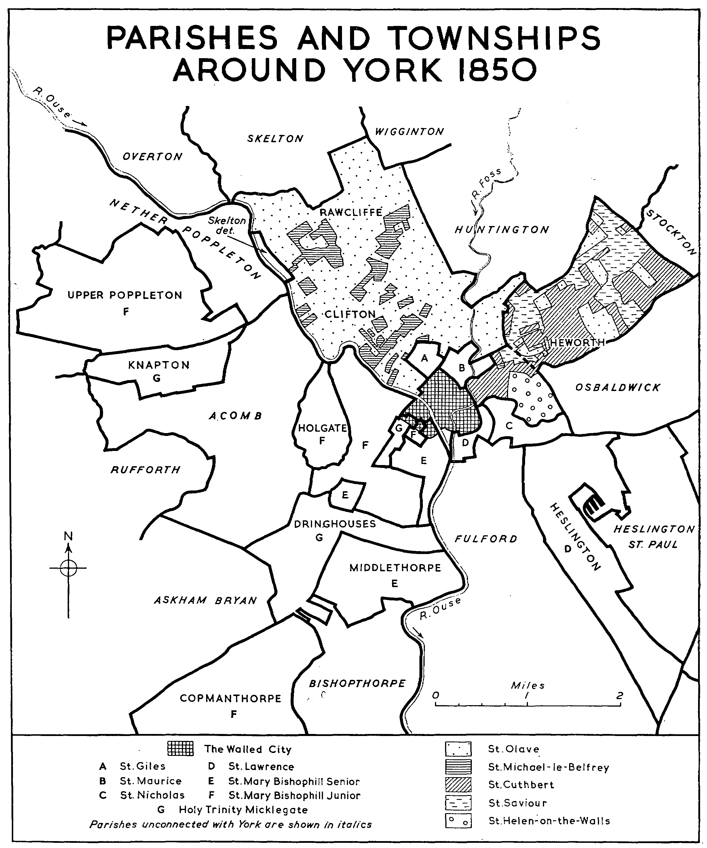
The boundaries of the city parishes were first accurately surveyed by a Captain Tucker for the Ordnance Survey between 1846 and 1851 and marked on a large-scale plan published in 1852. (fn. 1) The surveyors presumably based their decisions on the payment of rates and thus mapped civil parishes; and they found many boundaries hitherto undefined; nevertheless there is no reason to suppose that the boundaries they drew are not substantially those of the medieval parishes. Moreover the parishes of most of the benefices united in 1586 retained their identity for rating purposes and thus remained to be mapped by the surveyors. (fn. 2)
With one exception the sites of the religious houses had been absorbed into parishes: the Augustinian friary is perhaps represented by the southerly tail of St. Wilfrid's, the Dominican friary by the western portion of St. Martin-cum-Gregory, the Franciscan by the riverside portion of St. Mary's, Castlegate, and the Carmelite friary by the western portion of the south-western limit of St. Saviour's. Holy Trinity Priory became the nucleus of the parish of that name; St. Mary's Abbey falls into St. Olave's, St. Clement's into St. Mary's, Bishophill, Senior, and St. Andrew's into St. Lawrence's.
St. Leonard's Hospital had not been absorbed into a parish but became the extra-parochial area of Mint Yard. (fn. 3) The surveyors mapped three other extra-parochial areas: the minster yard with the Bedern—the intra-mural portion of the liberty of St. Peter and possibly representing the archbishop's shire of Domesday; (fn. 4) Davy Hall, the liberty of the medieval larderers; (fn. 5) and the liberty of the castle which had always been deemed outside the city. (fn. 6)
The cispontine intra-mural parishes lying west of the Foss, nineteen in number, were all small: St. Michael's, Spurriergate, for example, is mapped as about 5 acres—few were larger and several were smaller. These are the central city parishes. East of the Foss three of the parishes are larger than St. Michael's, Spurriergate, but still no larger than about 15 acres; the same is roughly true of the transpontine intra-mural parishes. With the areas of the minster, St. Leonard's, the castle, and the marsh (fn. 7) subtracted, the 30 intra-mural churches and their parishes are spread more or less evenly over the city.
Outside the walls there were, besides some extensive detached portions of intra-mural parishes, ten other parishes: five of these, St. Mary's Layerthorpe, St. Edward's, All Saints' and St. Helen's, Fishergate, and Clementhorpe (served by St. Clement's Priory), lost their identity at the union of benefices in 1586. The remaining five parishes, St. Olave's, St. Giles's, St. Maurice's, St. Nicholas's, and St. Lawrence's, together with extra-mural and detached portions of six inner parishes, surrounded the city and extended to the borders of the surrounding country parishes.
Even in the late, evolved condition in which the Ordnance surveyors found the parishes it may be possible to see something of the origin of the parochial arrangements of the environs of the city. On the north, St. Olave's—the old liberty of St. Mary— appears to have stretched from the Ouse to the border of Osbaldwick, although there, on the east, it was by this time represented only by a few detached portions. Out of this area had been taken the suburban parishes of St. Giles's (for the suburb of Bootham), St. Maurice's (for the suburb round Newbiggin), and St. Mary's, Layerthorpe, with the extension of St. Cuthbert's (for Layerthorpe). In the western portion of St. Olave's lay extensive detached portions of St. Michael-le-Belfrey; their shapes and their haphazard disposition suggest that they may have originated in gifts to the church but nothing is known of such a process. (fn. 8) If, as seems likely, St. Michael's is of older foundation than St. Olave's, (fn. 9) these places may have already had some connexion with St. Michael's when St. Olave's was founded and became the nucleus of the liberty of St. Mary.
On the north-east Heworth township was composed of parts of St. Olave's, St. Saviour's, and St. Cuthbert's. How this complex pattern of parochial jurisdiction grew up is not known: as has been said, it is possible that it was all originally St. Olave's. This is substantiated by the course of the boundary of the liberty of the city: this ran from the cross on Heworth Moor to the cross at the west end of Heworth village. (fn. 10) The exact course of this boundary line is not known: the Ordnance surveyors found it undefined and drew a straight line from Heworth Cross to a point about 130 yards down Tang Hall Lane. This was probably west of the true boundary. But even if the true boundary had followed approximately the line—farther east—of Heworth Road and Tang Hall Lane, all the detached portions would have lain outside the city liberty, as might be expected if Heworth were originally in the liberty of St. Mary. In other words, since the liberty of the city did not extend into 'foreign' parishes, it did not extend into the township of Heworth because that township had originally lain in the liberty of St. Mary.
PARISH AND TOWNSHIPS AROUND YORK 1850
East of the city lay St. Helen-on-the-Walls (detached portion), St. Nicholas's, and St. Lawrence's. The origin of these parishes is obscure. St. Helen's is Tang Hall Fields, (fn. 11) an estate of the Prebend of Fridaythorpe, but how the tithes of this prebendal estate came to form the rectory of St. Helen's is not known. St. Lawrence's no doubt anciently served a suburban population outside Walmgate Bar; whether St. Nicholas's, which divides the part of St. Lawrence's round the church from the part in Heslington, (fn. 12) was originally part of St. Lawrence's is not known. South of the cispontine city lay Fulford, a chapelry of St. Mary's; directly outside the walls were the two suburban parishes, All Saints' and St. Helen's, Fishergate, that were merged with St. Lawrence's in the 16th century.
West of the Ouse, the parishes and townships surrounding transpontine York are much simpler in structure. With the exception of Clementhorpe— united in 1586 with St. Mary's, Bishophill, Senior— there were no separate extra-mural parishes and jurisdiction lay in the hands of the three city parishes lying along the south-east wall: the two St. Mary's on Bishophill, and Holy Trinity, Micklegate. From the Ouse at Clifton to Bishopthorpe Road the city was surrounded by a detached portion of St. Mary's, Bishophill, Junior; the short stretch from Bishopthorpe Road to the river had been the meadows of St. Clement's—Nun Ings—and so after 1586 became part of St. Mary's, Bishophill, Senior. On the west the boundary followed Holgate Beck and Hob Moor; across Micklegate Stray, as might be expected, the surveyors found it undefined and so drew a straight line. Within this area, which comprised Bishop's Fields, Hob Moor, Micklegate Stray, and the riverside ings, lay no townships, and its boundary formed the boundary of the liberty; it was surrounded by Holgate, Dringhouses, and Middlethorpe. Holgate lay within the parish of St. Mary's, Bishophill, Junior, but for all other purposes was considered to be a township of Acomb: thus, in 1379, for example, Holgate paid its poll tax with Acomb; (fn. 13) for the purposes of collecting county rates in the 18th century the township fell in the upper division of The Ainsty. (fn. 14) The connexion with Acomb was a tenurial one: Holgate was parcel of the manor of Acomb. (fn. 15) Dringhouses lay within Holy Trinity, Micklegate, and had formed part of the original endowments of Christ Church, the predecessor of Holy Trinity Priory, (fn. 16) but tenurially Dringhouses lay outside the city and formed a separate manor. (fn. 17) Similarly Middlethorpe, although it lay in St. Mary's, Bishophill, Senior, parish, was a separate manor outside the city. (fn. 18)
Beyond these townships and remote from the city lay three more detached portions of these parishes: Upper Poppleton and Copmanthorpe (St. Mary's, Bishophill, Junior), and Knapton (Holy Trinity).
The parishes and townships mapped by the Ordnance surveyors remained stable for civil purposes (with certain minor exceptions) (fn. 19) until 1894. In that year (fn. 20) the extra-mural parishes which still had portions lying outside the city boundary (which had been greatly extended in 1884) were divided into two parts for civil purposes, within and without the city. The new civil parishes were named after the townships which lay within them so that St. Olave's became Clifton Within and Without, St. Cuthbert's became Heworth Within and Without, St. Mary's, Bishophill, Senior, became Middlethorpe Within and Without, and Holy Trinity became Dringhouses Within and Without. (fn. 21) In 1900 the whole of the city was made one parish for civil purposes. (fn. 22)
The Liberty of the City
No real attempt to define, and none at all to map, the liberty of the city was made until the 19th century and in some places its extent remained uncertain until the Ordnance surveyors marked the municipal boundary (which the boundary of the liberty had become) on their plan of 1852. As will be shown, the ridden boundaries, although they were in some places co-terminous with the liberty, for the most part went far outside it and were designed to determine the extent of a different and restricted jurisdiction— the common lands and strays.
Although for much of its history the city has had interests and jurisdiction outside it, the boundary of the liberty has always defined the city proper. This was the city to which the royal charters applied; within it the privileges so granted were exercised. Here property was held by burgess tenure and burgesses might be impleaded only in the city's courts; within this area the bailiffs were responsible for law and order and from it they collected money to pay the royal fee-farm; (fn. 23) the liberty was the 'true legal boundary of the city itself'. (fn. 24)
Broadly speaking, the liberty extended to the boundaries of the parishes and townships surrounding the city: east of the Ouse, the liberty of St. Mary (i.e. St. Olave's parish), Heworth, Osbaldwick, Heslington, and Fulford; west of the Ouse, Middlethorpe, Dringhouses, and Holgate. At the earliest time, therefore, the liberty probably comprised no more than the walled city, Knavesmire, Hob Moor, and perhaps Bishop's Fields.
Hob Moor and Knavesmire were ancient pastures of the city: their low-lying, marshy nature probably prevented any early settlement and their possession by the city was never disputed. Bishop's Fields are perhaps to be identified with the archbishop's 6 carucates in Domesday which were not built upon but were 'tilled in parcels by the burgesses': (fn. 25) such an origin would account for this area being within the liberty but, as archbishop's land, not commonable. (fn. 26) That this, like the city pastures, lay within the liberty, seems not to have been disputed but it must be added that in this western part of the liberty the rights of jurisdiction can seldom have been exercised: here were no burgess tenements or citizens to be taxed and civil disorder was unlikely to occur. The suburban dwellings, when they came, were an exception to this: in the 16th century the wardmote court was enforcing the paving of the footpath before houses in Holgate Lane; (fn. 27) and it was here that in 1433 the city successfully protested its liberty when the under-bailiff of the Sheriff of Yorkshire wrongfully arrested a man in the lane. (fn. 28)
But if it was not disputed in general terms that these three areas on the west lay within the liberty, this did not mean that the boundary was everywhere certainly known. From Bishop's Flete (the outfall of Holgate Beck into the Ouse) to Hob Moor Lane (now a footpath south of Pulleyn Drive) the boundary followed Holgate Beck and Hob Moor and presented no difficulties. Between Hob Moor Lane and North Lane, south of it, lay a detached portion of St. Mary's, Bishophill, Senior; on Parson's map of 1629 (fn. 29) this area appears to lie in the manor of Dringhouses but whether it always did so is not known. The Ordnance surveyors evidently thought the same for although they found the boundary along Hob Moor Lane undefined they drew their line along it to the Tyburn and thence south along the Tadcaster road to a boundary stone at what was then called Tyburn Lane. As will be shown, (fn. 30) it was uncertain in the 16th century whether or not this area lay within the common lands of the city.
There can be little doubt that from this last point the liberty followed the boundary of Knavesmire as shown on Parson's map. The Boundary Commissioners of 1832 recommended that the parliamentary boundary should follow this line; the Act itself declared that it should run from the Ouse at Nun Ings 'westward along the boundary of the city liberty to the point at which the same again meets the River Ouse' but did not define the boundary of the liberty. (fn. 31) By 1868, when the boundaries were reviewed, the Ordnance surveyors had drawn their line across Knavesmire and this was accepted by the commissioners as the boundary of the liberty. (fn. 32) East of Knavesmire the liberty no doubt always followed the northern boundary of Dringhouses manor and parish (i.e. the extra-mural portion of Holy Trinity, Micklegate, in Dringhouses) to the river; the boundary is shown on Parson's map and is marked by the Ordnance surveyors. North of this line lay Campleshon, Nun Ings, York Field, and Scarcroft which appear always to have lain within the liberty.
This was perhaps the primitive extent of the liberty: the walled city, Bishop's Fields, Hob Moor, and Knavesmire, and the associated lands to the east of it; to this were added, at times for the most part uncertain, the suburban extensions of the city. Some extensions had been made at least by the 12th century for grants of that period mention property held in burgage in Bootham, haymald land in Monkgate, and land in Layerthorpe subject to 'husgable'. (fn. 33)
West of the Ouse suburban extensions added nothing to the liberty for, as has been shown, all the lands where they might occur—Holgate Lane, The Mount, and Clementhorpe—already lay within it. East of the Ouse the suburban areas, later represented by the parishes of All Saints' and St. Helen's, Fishergate, St. Lawrence's, St. Nicholas's, St. Cuthbert's, and St. Mary's, Layerthorpe, appear to have been within the liberty though from what date is not known. The later medieval boundary at these points probably followed the boundaries of the parishes (or their equivalents) drawn by the Ordnance surveyors. The boundary at Heworth has already been described. (fn. 34) Tang Hall Fields (represented by the extra-mural portion of St. Helen-on-the-Walls) were in the liberty of St. Peter but were probably brought within the city liberty when the corporation obtained a lease of them in the 16th century. (fn. 35)
Suburban extensions within the liberty of St. Mary were, however, frequently disputed. In this area the surveyors' boundaries of St. Giles's and St. Maurice's parishes were not everywhere the boundary of the liberty. Boundaries in Bootham were constantly in dispute (fn. 36) and not settled until 1354 when only Marygate and the tenements adjoining the abbey precincts were left in the liberty of St. Mary. (fn. 37) Gillygate and possibly the area behind it, later mapped by the surveyors as St. Giles's township, now fell permanently within the city liberty. The 1354 agreement gave St. Mary's access along Gillygate to part of their liberty known as Paynlathes Crofts, lying between the north-eastern city wall and the Foss. The southern boundary of Paynlathes Crofts is not certainly known but Lund's map of 1772 probably shows it as the northern boundaries of the narrow strips of land contiguous to Lord Mayor's Walk and Monkgate. (fn. 38) The boundary of the liberty no doubt ran along this or a closely similar line until the city succeeded in bringing Paynlathes Crofts within the boundary of its common lands some time before 1570. (fn. 39)
East of Monkgate, St. Maurice's parish of 1852 extended into Jewbury, which had presumably lain within the liberty from very early times, and across the Foss into a small area, now occupied by part of the gasworks, lying between the river and Layerthorpe. This was probably the land of the vicars choral known as Vicars' Leas. (fn. 40) Beyond it lay a part of Heworth Moor that had always been common land of the city akin to its ancient pastures in Knavesmire. (fn. 41) The surveyors' boundary of 1852 ran from the Foss to Heworth Cross to include both these areas but whether the medieval liberty included Vicars' Leas is not known.
With these suburban extensions the liberty was complete: it will be seen that although in the Middle Ages its boundary was uncertain in some places and varied in others, it was, by the end of the 16th century, much as mapped by the Ordnance surveyors in 1852.
The Wards
Within the liberty, the city administered petty domestic regulations—street paving, cleansing of ditches, and so on—through the machinery of the wardmote courts. Up to the late 15th century the city was divided into six wards for these purposes. It is tempting to align these wards with the six shires of Domesday but there is evidence neither to support nor repudiate such a thesis. (fn. 42) In the late 14th century (fn. 43) the wards comprised Monk, Walmgate, Bootham, Coney Street, Castlegate, and Micklegate and the jurisdiction of each was closely defined. (fn. 44) The wardmote court books of 1490 and 1493 record six wards. Coney Street ward, which had consisted only of the parishes of St. Martin's and St. Helen's, had by this time been combined with Bootham. Micklegate ward was divided into two called Micklegate (comprising Holy Trinity, St. Mary's, Bishophill, Senior and Junior, and St. Clement's), and North Street (comprising St. Gregory's, St. Martin's, All Saints', and St. John's). (fn. 45)
There were still six wards in 1524, (fn. 46) but between that date and, at the latest, 1530, (fn. 47) they were reduced to four, Coney Street and Castlegate being distributed among the other three cispontine wards. (fn. 48) Traces of this reorganization—which appears not to have been recorded—are perhaps to be seen in the fact that in 1536 the rights of common pasture for Micklegate Ward were extended to inhabitants of some streets, previously in Coney Street and Castlegate wards, but now lying in the three other wards. (fn. 49) The city continued to be divided into the four wards of Bootham, Monk, Walmgate, and Micklegate until 1835. (fn. 50)
The wards extended outside the walled city into the suburban parishes outside the four bars, St. Giles's, St. Maurice's, St. Lawrence's, St. Nicholas's the Fishergate parishes of All Saints' and St. Helen's, and Holy Trinity, (fn. 51) and, in the 16th century at least, covered the liberty of the city. In 1580 Micklegate wardmote court required persons living in Holgate Lane to pave before their houses and demanded that one Peter Newarke should make a gate and fence at the lane end going from Dringhouses to Knavesmire. (fn. 52) In Monk Ward in the same year a man was presented for enclosing part of Heworth Moor for his mill hill. (fn. 53) In 1582 Walmgate court required a woman to open a lane leading from Fulford fields to 'Byerd Stones' (probably in St. Nicholas's parish south of the Hull road); (fn. 54) and in the same year Bootham court ordered the pasturemasters to repair the cow-byre in the Horsefair. (fn. 55)
The Ridden Boundaries
The boundaries of the liberty of the city which have already been described were not those with which the mayor was concerned in his perambulations. A comparison of the surviving descriptions of the ridden boundaries (fn. 56) with the known extent of the city's common lands (fn. 57) makes it clear that the mayor was, in fact, riding round the land over which the citizens enjoyed rights of pasturage and thereby confirming those rights. This interpretation is borne out by independent evidence. The riding was a regular event (perhaps even annual, as the citizens stated in 1564), (fn. 58) but was frequently forgone because of floods, (fn. 59) expense, or other reasons. On such occasions, however, maintenance of the city's pasturage was not left to chance: when the ridings were called off in 1549 and 1553, for example, the ward officers were ordered to ensure that the citizens were not deprived of pasturage in closes around the city. (fn. 60) Again, it was pasturage that the citizens had in mind when they asked in 1465 for an annual riding 'for that we may know our liberties and lose no part of our right that is due to the city'. (fn. 61) Like the common lands themselves, the ridden bounds remained substantially unchanged from the 14th to the 17th centuries, but the perambulations were greatly altered after the formation of the modern strays in the late 18th and early 19th centuries.
The perambulation normally began at the Ouse in Clifton, a short distance north of Almery Garth, and continued by way of a bridge in Little Ing, St. Mary's Hospital well, St. Mary's Abbey windmill, and the York-Clifton highway as far as the hospital of St. Mary Magdalen. Although St. Mary's Abbey thus fell within the boundary, not only the abbey site but also Almery Garth were exempted from the city's pasturage: the boundary of 1484 ran along Bootham highway to exclude the garth, and, although the mayor attempted to claim right of pasturage there in 1756, (fn. 62) the 1802 perambulation went around the garth on its way to the starting-point on the Ouse.
From St. Mary Magdalen Hospital the boundary followed the present Burton Stone Lane, past Clifton Windmill, St. Mary's Abbey gallows, and a 'watergate' on the road leading into the Forest of Galtres, as far as the York-Huntington highway; it followed that road to White Stone Cross, above Yearsley Bridge, went down to the Foss, and followed the river to St. Mary's Abbey watermills. In 1721, 1733, and 1802, the perambulation took in the ground between the York-Huntington road and the Foss, from the present Mille Crux House to Yearsley Bridge: (fn. 63) there is, however, no evidence that the right of pasturage in this ground was a late acquisition.
The boundary thus coincided with the limits of the city's pasturage in Clifton, taking in all the grounds over which half-year rights were enjoyed but not the commons of Clifton, Rawcliffe, Wigginton, and Huntington over which the citizens intercommoned and which would have involved an excursion of some seven miles. In 1764 the half year grounds and commons were replaced by Bootham Stray, pastured in severalty by the freemen of Bootham Ward; accordingly, the perambulation of 1802 proceeded round the new stray, while still including what were now described as the 'former' half-year lands. And, in 1819, the perambulating party went out directly to the stray by way of Gillygate and the Wigginton road: the old half-year grounds had been forgotten.
On the north-east of the city the boundary lay in Heworth. From the west bank of the Foss it was possible to cross the river by St. Mary's mills; (fn. 64) but after the decay of the mills it was necessary, in 1802, to make a detour by Monk Bridge. In all the early perambulations the next boundary mark was a cross on Heworth Moor near the Stockton road, but it seems likely that the boundary would have taken in the city's half-year ground of Grange Fields (later Grange Closes); the 1721, 1733, and 1802 perambulations did, in fact, follow such a course.
From the first boundary cross on Heworth Moor the boundary continued to a second at the western end of Heworth village, on to Thief Bridge (later Tang Hall Bridge), across Tang Hall Green, and along the eastern side of Tang Hall Fields.
As with those in Clifton, the city's half-year grounds in Heworth all fell within the boundary: so did that part of Heworth Moor which was enjoyed in severalty by the citizens, as well as Tang Hall Fields which were part of the city's pastures after 1525. A journey of 10 miles would have been involved had the perambulation gone out to the limit of the city's right of intercommoning in Stockton-on-the-Forest: that journey to Sandburn Cross was, indeed, undertaken in 1802 but although it was then described as being 'according to ancient usage', it is included in none of the earlier descriptions of the boundary. In 1817 the half-year grounds and commons were replaced by Monk Stray, enjoyed in severalty by the freemen of Monk Ward: and in 1819 the perambulation proceeded directly by road from Bootham Stray, across Monk Bridge, along the present Heworth Green, and so round Monk Stray.
On the south-east of York the boundary took in the old parish of St. Nicholas and crossed the lands of Gate Fulford. From Tang Hall Fields it proceeded by a cross on the road to Osbaldwick to the present Hull road, turned along that road towards York as far as a cross and a bridge near St. Nicholas's Hospital windmill, and continued along a lane to a cross and St. Leonard's Hospital gallows in the Green Dykes. The perambulations of 1693 onwards included a short excursion eastwards along the Hull road to a cross and gallows: the Gallows Hole of 1721 is still shown on modern maps. (fn. 65)
From Green Dykes the boundaries of 1374–5 and 1413 continued across to the York-Fulford road, but the description of 1374–5 notes that the city possessed pasturage as far as out 'Polebrigg'. Later perambulations proceeded from Green Dykes to a ditch made by the inhabitants of Heslington 'beyond Tilmire', and that of 1721 went to 'Pool Briggs'. The city did, in fact, have pasturage in Tilmire, and Pool Bridge is on the Fulford-Wheldrake road. From Tilmire the boundary returned by a lane or 'outgang' to a cross standing in the York-Fulford road near Hall Garth Syke; (fn. 66) and thence to Hawk's Well (fn. 67) and the Ouse.
In 1759 the half-year grounds and commons in Fulford were replaced by Walmgate Stray, enjoyed in severalty by the freemen of Walmgate Ward. Accordingly, the perambulation of 1802 continued from Green Dykes around the stray, along the YorkHeslington road, across certain closes to a public house (probably 'The Light Horseman') in Fishergate, and so to the well and the Ouse. The half-year grounds in the parishes of St. Nicholas and St. Lawrence were not replaced by an addition to Walmgate Stray until 1826: this accounts for the continued perambulation of the grounds north and south of the Hull road and the excursion into the closes near Fishergate in 1802. Again, the perambulation of 1819 went around the stray, but still involved the establishment of the city's rights of pasturage in the half-year lands, and no further perambulations were made which would have revealed the final withdrawal from half-year grounds on this side of the city.
In all probability this was the end of the first day of the perambulations; the party, with some members on horseback, never crossed the Ouse but began on the east bank in Clifton and finished on the east bank in Fulford. The second day's expedition took the mayor towards Middlethorpe, Dringhouses, and Acomb; it began at Skeldergate Postern, skirted the Ouse past Hawk's Well on the opposite bank, and reached its first boundary mark at Bampton Well. (fn. 68) The boundary continued along the river through the meadows of St. Clement's Nunnery, turned along a balk to Haydale Cross in the York-Middlethorpe road, and reached Knavesmire through Bustard Lane.
The limits of Knavesmire were followed as far as the south-western end of Dringhouses village; (fn. 69) the perambulation continued along Knavesmire Lane to the York-Tadcaster road, through Dringhouses village, along North Lane and across a stream, proceeding along its western bank to Yorks Moor. It continued round Yorks Moor as far as the outgang leading to Hob Moor, along the southern side of Holgate South Field and so back to the stream. Yorks Moor was the name given to the present Hob Moor, (fn. 70) and 'the outgang leading to Hob Moor' would seem to refer to an access way into Acomb Moor from either the south-west or north-west corner of Yorks Moor: Parson's map of 1629 shows 'Acomb Hob Moor' adjoining Yorks Moor. (fn. 71)

THE RIDDEN BOUNDARIES
The Dringhouses section of the boundary presented the perambulators with some difficulty in 1500: having reached Yorks Moor by the route described, several of the party protested that they had gone beyond the bounds of the city, and that they should have reached the York-Tadcaster road at the eastern (i.e. the north-eastern) end of Dringhouses village. All the earlier perambulations do, in fact, appear to have passed the gallows at the northeast end of the village and proceeded along the present Hob Moor Lane: it is not clear whether or not they then circumscribed Yorks Moor as they did in 1500. The perambulations of 1693 and later certainly passed through Dringhouses village.
From Yorks Moor the boundary followed the stream (Holgate Beck) to Holgate Bridge and on to the Ouse at 'Fletebridge' near the tilehouse at the western end of Bishop's Fields. The boundary thus took in all the city's half-year grounds in this direction, as well as the pastures of Knavesmire and Hob Moor. The final section of the perambulation also included Bishop's Fields which were never enjoyed as pasturage by the citizens. In 1819 the boundary was not perambulated in the usual way; the mayor rode around Knavesmire and into Hob Moor, and went back and forth through the halfyear grounds, causing proclamations of the city's rights to be made, gates taken off their hinges, and fences broken: half-year rights were becoming increasingly difficult to maintain. No perambulations were made after the half-year grounds were replaced by additions to Knavesmire and Hob Moor in 1824.
The descriptions of the boundaries leave little doubt that the perambulations were concerned with the city's pastures; and as ridden in 1819 the bounds were said to be those 'of the commons or strays . . . belonging to the several wards . . . and also the half-year lands in or belonging to Walmgate and Micklegate wards over which a right of stray hath been immemorially used . . . by the freemen . . . of the last mentioned wards'. Shortly after 1819 it was pointed out that nothing in the perambulation described the 'true legal boundaries of the city itself': 'The reason of this appears to be, that all the perambulations had for their object not so much the exact limits of the city as the extent of those lands in the suburbs or vicinity over which the citizens exercised rights of stray and average.' (fn. 72)
The inclosure of commons and moors, and the extinction of half-years rights, made perambulations unnecessary; the extensive and scattered pastures were replaced by strays whose boundaries were precisely known, and in 1830 it was recommended that no further perambulations should take place. (fn. 73) The decision was no doubt regretfully made for the riding had become a festive occasion. Even on the earlier ridings the mayor was probably accompanied by civic officials and commoners: in 1485, for example, he was to be joined by either four or two members of each craft, half of them young men lest tradition should be forgotten. (fn. 74) The following of 1802 was even larger: some of the aldermen, several other members of the corporation, the foreman of the commons with three commoners from each ward, most of the pasture-masters, the city officers, and a crowd of citizens. (fn. 75) In 1819 the fencebreaking and gate-lifting were interspersed with proclamations of the citizens' rights of pasturage, the giving of three cheers, and halts for cakes and ale: on the first day the junior officer at mace had carried twelve dozen cakes and a six-gallon barrel of ale on his horse. And on each of the two evenings certain members of the party were invited to dinner in York hotels at the expense of the common chamber.
The Ainsty
Besides its liberty and its rights of common the city had an even wider jurisdiction. The wapentake of The Ainsty, which extended west and south of York as far as Tadcaster bridge and was bounded by the rivers Ouse, Wharfe, and Nidd, (fn. 76) is first mentioned in association with the city in the early 13th century. The wapentake occurs in Domesday but, of course, included none of the villages surrounding York which gelded with the city: these all lay east of the Ouse. (fn. 77) It appears to have been named from a place in Copmanthorpe that was probably the wapentake meeting-place. (fn. 78)
The justices who visited Yorkshire between 1218 and 1219 found the city in possession of The Ainsty and inquiry was made about it. The city's case was that the wapentake was appurtenant to the town and that the town had been granted to them by King John with all its appurtenances; apparently they had persuaded the under-sheriff at the time that this was indeed so and had thus secured possession. (fn. 79) Henry III's advisers were less easy to convince. In 1220 the wapentake was taken into the king' hand, restored in 1221, but resumed by the king in 1222 after a jury of the neighbourhood had been interrogated at the Exchequer. (fn. 80) It seems, however, that the city in due course recovered possession of it, for in 1276 the mayor and bailiffs were accused of letting it to farm for 17 marks instead of the customary £5. (fn. 81) Four years later, before the King's Bench, the king's attorney demanded the wapentake for the king. The citizens once more had recourse to King John's charter. It was not difficult for the royal lawyers to point out that there was no mention of the wapentake in it: moreover the dating clause had been tampered with, so besides losing the wapentake the city was taken into the king's hand and the mayor consigned to prison. (fn. 82) In 1282 the mayoralty was restored to the citizens: at the same time The Ainsty was temporarily restored to their hands, together with all receipts since the previous Michaelmas, until the king should make his will known in the matter. The city and The Ainsty were returned to the citizens the following year upon payment of a large fine. (fn. 83)
The city appears to have retained The Ainsty at farm throughout the 14th century. In 1396 the county of the city was created but The Ainsty, although still farmed by the city and administered by the city bailiffs, was not annexed to it until 1449. (fn. 84) From that date the mayor and citizens had 'the hundred with its privileges and franchises' and the city sheriffs, who had replaced the three city bailiffs in 1396, had 'full power within the hundred'. The grant was made because the city was said to be 'in decay' but the economic value of the annexation is not known.
From that date until 1836 the city administered The Ainsty as a county authority. In 1463 the mayor and aldermen were made justices of the peace and of oyer and terminer within the wapentake, and the mayor escheator therein. (fn. 85) The city's rights of office in the wapentake were sometimes usurped: in 1555 the Clerk of Admiralty had obtained the coronership and was pursued by a quo warranto; (fn. 86) in 1661 four gentlemen of The Ainsty 'who were not free of the city' were granted a commission of the peace but the commission was superseded when the city protested its franchise. (fn. 87) When the wapentake was to be severed from the city in 1836 the inhabitants petitioned Parliament and expressed themselves satisfied with the way in which the judicial duties had been performed by the city magistrates. They derived, they said, many advantages from the certainty and dispatch with which they were able to conduct parochial and other public business at the Petty Sessions regularly held by the magistrates in the Guildhall on Tuesdays, Thursdays, and Saturdays, the more especially since they came to markets and fairs on Thursdays and Saturdays. (fn. 88)
Apart from its judicial functions the city's chief administrative concern in the wapentake at least in the 15th, 16th, and 17th centuries was with arraying armed forces, The Ainsty being called upon to send half the contingent. (fn. 89) Administration extended to all county matters. The city was responsible for the repair of bridges and in particular the York side of Tadcaster Bridge (fn. 90) on which distinguished visitors were sometimes met as they proceeded to the city. (fn. 91) In 1536 money to pay York's M.P.s was to be raised both in the city and The Ainsty (fn. 92) and five years later the wapentake had to pay a share of the gifts made to Henry VIII for his benevolence after the Pilgrimage of Grace. (fn. 93) Again in the 16th century the mayor had the task of executing Elizabethan social and economic legislation—the poor law, the regulation of worship, and the control of wages in the extensive county of his city. (fn. 94) In 1721 the townships of The Ainsty pay a share of the cost of repairing the House of Correction and prominent in the administration by the city in the 17th and 18th centuries is the issue of ale-house and maltsters'licences. (fn. 95) Until 1736 freeholders of The Ainsty appear to have been disabled of their parliamentary franchise: in that year Drake, the York historian, presented various documents as an expert witness at the Commons and the freeholders' votes were allowed without a division. (fn. 96)
The wapentake was administered by the city through bailiffs who, it was enacted in 1497, must be personal servants of the sheriffs. (fn. 97) These officers occasionally met with opposition from manorial officers in The Ainsty in the performance of their duties: in 1555, for example, Lord Wharton's bailiff at Healaugh rescued a prisoner from the city bailiffs and the following year the sheriffs complained that they had been unable to impound 'waste' sheep because they were resisted by the same man. (fn. 98) A dispute about the appointment of bailiffs in 1574 shows that the profits of their office comprised all fines in the wapentake not amounting to more than 11s. (fn. 99) In the late 18th century at least, The Ainsty was divided, for the assessment of the county rate, into two equal parts known as upper and lower divisions, the southern boundary of the upper division being a line joining Holgate, Angram, Wighill, and Thorp Arch. (fn. 100)
Other Jurisdictions
The city's rights over rivers are first specified in King John's charter where the citizens are granted a water-way in the Wharfe and in the Ouse as far as Boroughbridge. (fn. 101) The city's rights of navigation were not further defined until the 18th century: an Act which set up trustees to improve the Ouse above York set an upper limit to the Ouse trustees' jurisdiction below Widdington Ings (W.R.); (fn. 102) jurisdiction over the river below Skelton Railway Bridge near Goole (W.R.) was transferred to the Aire and Calder Navigation by an Act of 1884. (fn. 103) Within the confines of the city liberty the city's franchise did not extend over the whole of the river: (fn. 104) of the western half of the water only that portion from Bampton Well to 'Bishopflete' (fn. 105) and of the eastern, from Hawks Well to 'Fetes' or Little Ing (fn. 106) lay within the liberty.
The city liberty, moreover, was not homogeneous. Within it lay the liberties of the Church of York and of the religious houses—jurisdictions defined more by tenure than by territory and about which there were constant disputes. (fn. 107) Even where the boundary of a liberty was not disputed the city's hand might have to be strengthened by royal interference as in 1321 when the king had to order the dean to permit the constables of the wards to levy without hindrance a tallage from tenements held of the king in chief. (fn. 108) The castle liberty, as it might be called, was presumably defined by the moat, though even here disputes might arise. In 1422 the Sheriff of Yorkshire arrested a woman who was living in a house on Castle Hill (probably at the southern end of Castlegate); the mayor protested the city's rights of jurisdiction but the sheriff was only prevailed upon to restore the woman to her house by the arbitration of one of his predecessors. (fn. 109)
Around the liberty of the city lay the three ridings of the county: the North Riding extended from the Ouse on the north-east to the southern boundary of Osbaldwick parish; Fulford and Heslington lay in the East Riding; on the west bank of the river lay The Ainsty—a wapentake variously of the West Riding and of the city itself.
For a few years in the early 17th century several of the surrounding townships and parishes in the county were 'annexed' to the city. In 1632 the North and East Ridings petitioned the Crown that 'of late the citizens of York, upon some pretext unknown to the petitioners' had got Clifton, Heworth, Osbaldwick, Heslington, and Fulford annexed to their liberties and asked that the appropriate county rates should be levied on the city. (fn. 110) In November of the same year Wentworth made an order apportioning the rates between the disputants (fn. 111) whereby the townships paid with the ridings 'for all things of the king's service'—an order which he confirmed in 1635. (fn. 112)
By 1637 the mayor and aldermen realized they had got more than they had bargained for: the annexed townships were the source of constant dispute with the authorities of the ridings and, presumably because Osbaldwick, as a prebend, lay in the liberty of St. Peter, with the chapter. The common council, when called upon to support the mayor in a request to Wentworth to restore the status quo, were not slow to point out how embarrassing the situation was, for it had been Wentworth who, at their special request, had obtained the privileges for them. A suitably humble petition was drafted; Wentworth's reply is not extant but nothing more is heard of this unwarrantable aggrandisement of the city's already extensive jurisdiction. (fn. 113)
Apart from these five years the relationship of the city with the ridings appears to have been straightforward and largely untroubled. Disputes about the collection of royal taxes in Bootham occurred both before and after the settlement with St. Mary's in 1354. Before the settlement it was sometimes uncertain whether Bootham should pay with the city or the North Riding; (fn. 114) in 1407 the city claimed that it should be taxed as a suburb rather than as part of the North Riding—it had probably been taxed by both authorities on this occasion. (fn. 115)
Parts of the city lay within yet one other jurisdiction or liberty—that of the royal forest of Galtres. (fn. 116) A perambulation of the forest in 1316 placed the boundary at the foot of the city wall from Layerthorpe Bridge right round the northern circuit to the Ouse. (fn. 117) In the 15th century forest perambulators went so far as to demand that Layerthorpe Postern should be opened to them so that they might proceed along the very foot of the wall. (fn. 118) In one respect the forest jurisdiction was a matter for constant dispute for within it lay some of the city's pastures and commons. (fn. 119) Otherwise the forest jurisdiction does not appear to have impinged on the city. No doubt there was little game in the immediate vicinity of the walls to tempt suburban citizens to break the forest laws: they probably obtained the right to have their dogs go unhambled as early as the mid-13th century, possibly because it was felt that the dogs could do little harm. (fn. 120)
The Modern Boundaries
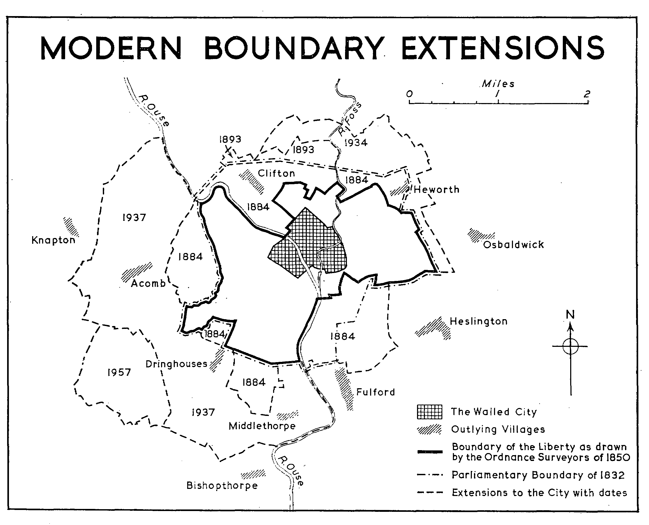
The first modification of the ancient liberty of the city was made in 1832 when the parliamentary borough was defined. The boundary commissioners reported (fn. 121) that no perambulation of the city boundaries had taken place since 1802: if they did not overlook that of 1819, they probably concluded that its peculiar nature made it unsuitable for their purpose. (fn. 122) Perambulations, as has been shown, were not of the liberty, and would not therefore have helped the commissioners much; but they declared that it was in consequence of the lack of them that 'many doubts and much uncertainty prevail . . . at particular points, more especially on the north-east side and again on the south and south-west'. It was in these areas—Heworth, Knavesmire, and Dringhouses— that the Ordnance surveyors were to find much undefined twenty years later. When the parliamentary boundary was made (fn. 123) it took a wide sweep across the north to include Clifton and Heworth, and on the south-east embraced part of Fulford. For the rest it followed the boundary of the ancient liberty: what this meant on the south, across Knavesmire, is uncertain; (fn. 124) by 1868, when parliamentary boundaries were reviewed again, (fn. 125) the Ordnance surveyors' definition of the municipal boundary (as the liberty had by then become) was accepted as authoritative. No alteration of the parliamentary boundary was recommended at this latter date and none was made.
On 1 January 1836 the city became a municipality under the Corporations Act of 1835: it was intended that the new authority should have jurisdiction within the ancient liberty but not beyond it, but some faulty drafting left the fate of The Ainsty uncertain. (fn. 126) The matter was held in abeyance during the early part of 1836: in February the corporation petitioned to retain Quarter Sessions for The Ainsty (fn. 127) but later deferred the appointment of constables (fn. 128) in the wapentake because they then expected the legislation that actually came into force in August. Their expectation did not prevent them from levying a county rate in The Ainsty in June. (fn. 129) The Municipal Corporations (Boundaries) Act of 1836 (fn. 130) established The Ainsty as part of the West Riding for all pur poses and settled the boundaries of the city as those of the ancient liberty. (fn. 131)
The first extension of the municipal boundaries came 50 years later in 1884. By the York Extension and Improvement Act of that year (fn. 132) the city was extended on the north to the parliamentary boundary of 1832 and on the south and west beyond it into Holgate, Dringhouses, Knavesmire, and Fulford. The parliamentary boundary of 1832 was not affected by the Act but by the Redistribution of Seats Act of 1885 the parliamentary boundary was extended to the new city boundary of the previous year. (fn. 133)
MODERN BOUNDARY EXTENSIONS
In 1893 the city was again extended on the north, to bring within the boundaries some suburban building in the Haxby Road district; this area was brought within the parliamentary boundary by the Representation of the People Act of 1918. (fn. 134) The city was extended in the same area and on the east in 1934, (fn. 135) but the greatest extension of the boundaries was in 1937 when Acomb, Dringhouses, and Middlethorpe were brought within the city. (fn. 136) The extensions of 1934 and 1937 were brought within the parliamentary boundary by the Representation of the People Act, 1948. (fn. 137) About 500 acres south of Acomb in Acomb Moor were added to the city in 1957; (fn. 138) for parliamentary purposes they remained in Barkston Ash constituency.
The divison of the city into four wards remained stable until 1835 when the number was increased to six; the two new wards were called Castlegate and Guildhall. The boundaries of the six wards were rearranged to accommodate the extensions of 1884 (fn. 139) and 1893. (fn. 140) Proposals to increase the number of wards or to rearrange the existing ones were under discussion in 1912 (fn. 141) but no alteration was made until 1924 when the number was increased to twelve; (fn. 142) the new wards were named Clifton, Heworth, Fishergate, Holgate, Scarcroft, and Knavesmire. The extensions of 1934 were placed in Walmgate, Heworth, and Clifton wards. A new ward, Acomb, was created in 1937; (fn. 143) the extension of 1957 was divided between Acomb and Micklegate wards. (fn. 144)