Survey of London: Volumes 31 and 32, St James Westminster, Part 2. Originally published by London County Council, London, 1963.
This free content was digitised by double rekeying. All rights reserved.
'Swallow Street to Glasshouse Street', in Survey of London: Volumes 31 and 32, St James Westminster, Part 2, (London, 1963) pp. 57-67. British History Online https://www.british-history.ac.uk/survey-london/vols31-2/pt2/pp57-67 [accessed 18 April 2024]
In this section
CHAPTER IV
Swallow Street to Glasshouse Street: Swallow Close and Round Rundles
This irregularly shaped area (fig. 6), bounded on the north by Vigo Street and Glasshouse Street, on the south by Piccadilly and on the west by the backs of the houses on the east side of Sackville Street, formed part of the land acquired between 1531 and 1536 by Henry VIII, and is still owned by the Crown.
The western portion, consisting of some five acres of pasture, had until its surrender to Henry VIII belonged to Thomas Hobson, but by 1540 had been leased by the Crown to Thomas Swallow, from whom its name Swallow Close was derived. (fn. 6) In 1568 Queen Elizabeth leased this ground to Christian Golightly, widow, for twenty-one years, (fn. 7) and in 1575 a further term of thirty-one years from Lady Day 1589 was granted to Nicholas Golightly. (fn. 8) The plan of 1585 marks it as in the possession of Widow Golightly. In 1610 it was included in a Crown lease of extensive lands to John Eldred and William Whitmore for sixty years but in 1618 it was assigned to Michael Pulteney (fn. 9) who in turn assigned the residue of the term to Edmund Hopper in 1619. (fn. 10)
The eastern triangular portion, bounded on the north-east by Shugg Lane and on the south by the road from Colnbrook to London, is marked on the plan of 1585 (Plate 1) as containing three closes. The centre close is marked as the 'Rounde ringill' and in the occupation of Mr. Poultney, and by 1650 the strip on the west (which was formerly part of the lands of the Abbot of Abingdon) had been incorporated with it. At this date a 'tenement strongly built with bricke walles', described as in the occupation of Samuel Morris, had been erected on the easterly close (whose site corresponds with that of the present Piccadilly Circus), and as well as a number of substantial outbuildings there was a garden enclosed by a brick wall. (fn. 10) All three of these closes had formed part of the lands leased by the Crown in 1610 to Eldred and Whitmore, and in 1676 they were all referred to as 'Round Rundles'. (fn. 11)
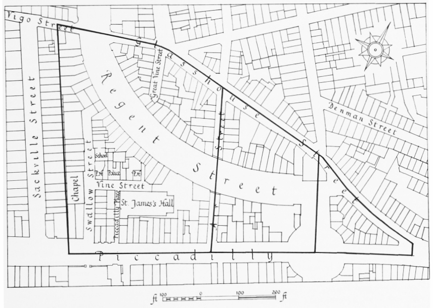
Swallow Close and Round Rundles, layout plan. Based on the Ordnance Survey, 1870–5
After the Restoration both Swallow Close and Round Rundles were leased by Queen Henrietta Maria's trustees to those of Henry Jermyn, Earl of St. Albans, by whom the area was developed in the 1660's.
Piccadilly
Only the northern side of Piccadilly between Great Windmill Street and the west side of Burlington Arcade lies within the area covered by the present volumes. The rest of the north side is in the parish of St. George, Hanover Square. The south side between the Haymarket and St. James's Street has been described in volume XXIX of the Survey of London; the rest of this side is in the parishes of St. George and St. Martin in the Fields. The origin and early history of Piccadilly is described in the present volumes in Chapter II, and the rebuilding of the Circus, Swan and Edgar's and the Piccadilly Hotel in Chapter VI.
Ogilby and Morgan's map of 1681–2 (Plate 3a) shows that from just east of Air Street to just west of Ship Yard (on the line of Sackville Street) the houses in Piccadilly were not built right out to the street frontage but stood back probably behind small gardens.
Further west it may be noted that the streetwalls of the large houses built in Stone Conduit Close—Burlington House, Sir Thomas Clarges's house and Lord Townshend's house—seem to have been set back to leave a broad foot-path along the southernmost part of their properties. At Burlington House this was about twenty feet wide. (fn. 12) The present building-line and pavementwidth west of Sackville Street still preserve approximately these late seventeenth-century boundaries.
The evidence of early views of Clarendon and Burlington House is that the outer edge of the foot-path was bordered by posts and rails and a line of trees. The path was limited to pedestrians by transverse posts and rails. In front of Burlington House these last were not renewed after about 1737. (fn. 12) In 1723 Macky noted the existence of 'large grown trees' before the gate of Sunderland House and of Lord Townshend's former house. He nevertheless remarked how 'naked' the lengths of 'dead wall' made this part of Piccadilly. (fn. 13)
By 1767 the paving commissioners were claiming the twenty feet in front of Burlington House wall as part of the public way, alleging that its tenure as private property had been relinquished. (fn. 12) But as late as 1836 the owner of Burlington House evidently considered his property extended sufficiently far south of the streetwall to accommodate an intended row of small shops, (fn. 14) which was not, however, built.
In 1898 the London County Council considered the widening of Piccadilly on the north side between the Circus and Sackville Street, and in 1903 an agreement was reached with the Commissioners of Woods and Forests (who owned the freehold of almost all the land required) for the implementation of the scheme by stages as the rebuilding took place. (fn. 15)
The first stage was carried out in 1908, when the building of the Piccadilly Hotel was completed, and the front of Denman House at Nos. 19–20 Piccadilly was set back in 1912–13. (fn. 16) The section east of Air Street was widened in 1925–7 with the rebuilding of the Regent Street Quadrant, (fn. 17) and that between Sackville Street and Piccadilly Place was completed in 1956. (fn. 18)
William Lawson or Larson, 'statute-maker', lived on the north side of Piccadilly, between Sackville Street and Swallow Street, from 1670 until his death in 1692. (fn. 19) He was presumably the sculptor who was paid for a statue of Diana for Chatsworth in 1692. (fn. 20) In May 1693 there is a reference to the nuisance caused by a house lately erected behind Lawson's widow's house 'for the melting of Mettall for the Casting and makeing of Brasse Guns and Brass Mortars'. (fn. 21)
The St. James's Hall, Piccadilly
Demolished
In 1853 Charles Moreing of No. 14 Regent Street (fn. 22), architect, entered into articles of agreement with the Commissioners of Woods and Forests whereby he undertook to repair or rebuild No. 28 Piccadilly and the extensive workshops situated behind. Subsequently Moreing acquired several adjacent small houses in Vine Street and George Court (both now Piccadilly Place) and in 1855 he was negotiating for the sale of his interest to a public company which was to be formed for the purpose of erecting a large concert hall there. (fn. 23) The provisional committee of the St. James's Hall Company, which was formed about this time, included William Chappell and T. F. Beale, musical publishers, (Sir) Julius Benedict, conductor, and John Ella, violinist and concert director. In its prospectus the company stated that 'The growing taste for Musical Performances of a high order, and upon an extensive scale, renders it necessary that some suitable provision should be made at the West End of London for such entertainments'. The need for a hall had long since been supplied in Liverpool, Birmingham and elsewhere, but 'the Metropolis remains singularly deficient in proper accommodation for such performances. . . . The proposed building will be expressly designed with a view to aid the effect of instrumental and choral performances.' (fn. 24)
In November 1855 the company's architect, Owen Jones, submitted designs for a public building to be called St. James's Hall, and in February 1857 the Commissioners approved them. Shortly afterwards the company acquired the leases of Nos. 69, 71 and 73 Regent Street, which abutted on the north side of the site of the hall. This valuable addition was used to provide an extra entrance to the hall, and a first-class restaurant. (fn. 24)
The St. James's Hall, which for nearly half a century was to be London's principal concert hall, was erected in the centre of the block now occupied by the Piccadilly Hotel, and possessed access to Piccadilly on the south and Regent Street on the north (fig. 7). On the ground floor there were two small halls, above which stood the great hall. (fn. 25) Owen Jones had been superintendent of the works at the Great Exhibition of 1851, (fn. 26) and it was therefore not surprising that, in the opinion of The Builder, his design displayed novelties of construction which may 'be found to belong to the commencement of an alteration in the current practice of building. We refer especially to the use of iron, less as an auxiliary than as a main element in the framework of a structure.' (fn. 27) The builders were Messrs. Lucas. (fn. 28) The St. James's Hall was opened on 25 March 1858, with a charity concert in aid of the Middlesex Hospital. (fn. 29)
The three concert halls were contained in an oblong building some 140 feet in length from east to west, and 75 feet in width, including the corridor along the south side. In the ground storey were two halls of similar size, the east hall being planned in the form of a wide but short-armed cross with galleries in its east, north and south arms. The west hall was an oblong with a gallery on its long east side and a platform recessed into the west wall. The oblong body of the great hall on the first floor was some 95 feet long and 57 feet wide. A straight-fronted gallery extended along the north and south sides, and across the east end. Each long side wall was divided by piers into eight equal bays, and in each end wall was a great arch, 38 feet wide, the west opening to an apse containing choir seating and an organ, and the east opening to the back stalls and the gallery.
The architectural scheme and decoration of the great hall, designed by Owen Jones, must have been impressive and in many ways beautiful (Plate 30b). There was probably little of interest below the gallery, which had a railing of cast iron, with geometrical frets in panels, rather Moorish in character. In every bay of the side walls was a tall round-arched recess, containing a decorative panel below a 'Florentine' window of two lights, the marginal frames of these recesses being decorated with 'flowing scroll ornaments, on a ground of orange-chrome yellow'. The round arches were, in turn, set in recesses with two-centred arches, forming tympana that were modelled with 'groups of figures in bold relief, holding scrolls on which are inscribed the names of Mozart, Handel, Beethoven, Haydn, Auber, Meyerbeer, Spohr, Weber, Gluck, Purcell, Rossini, Cherubini, and other eminent composers'. On the piers between these pointed arches were slender colonnets, supporting the ribs outlining the groins over the recesses, and traversing the surface of the great semi-circular barrel-vaulted ceiling, forming a pattern of lozenge-shaped panels over which smaller lozenges were placed, the whole being decorated with arabesques 'rich in colour and gilding; the smaller panels . . . Alhambran gold on a red ground'. The wide marginal surrounds of the great east and west arches were simply treated, being divided by ribs into three concentric bands, and the semi-dome of the western apse was divided by interlacing ribs into a pattern of lozenges, diminishing in size towards the crown. The hall was 'not lighted at night by a central chandelier, but by gas stars of seven jets each, suspended from the ceiling. The figures in the various designs were modelled by [Raphael] Monti; the other enrichments, by De Sarchy, are of plaster and canvas run into moulds'. The floor of the hall was of marqueterie. (fn. 30)
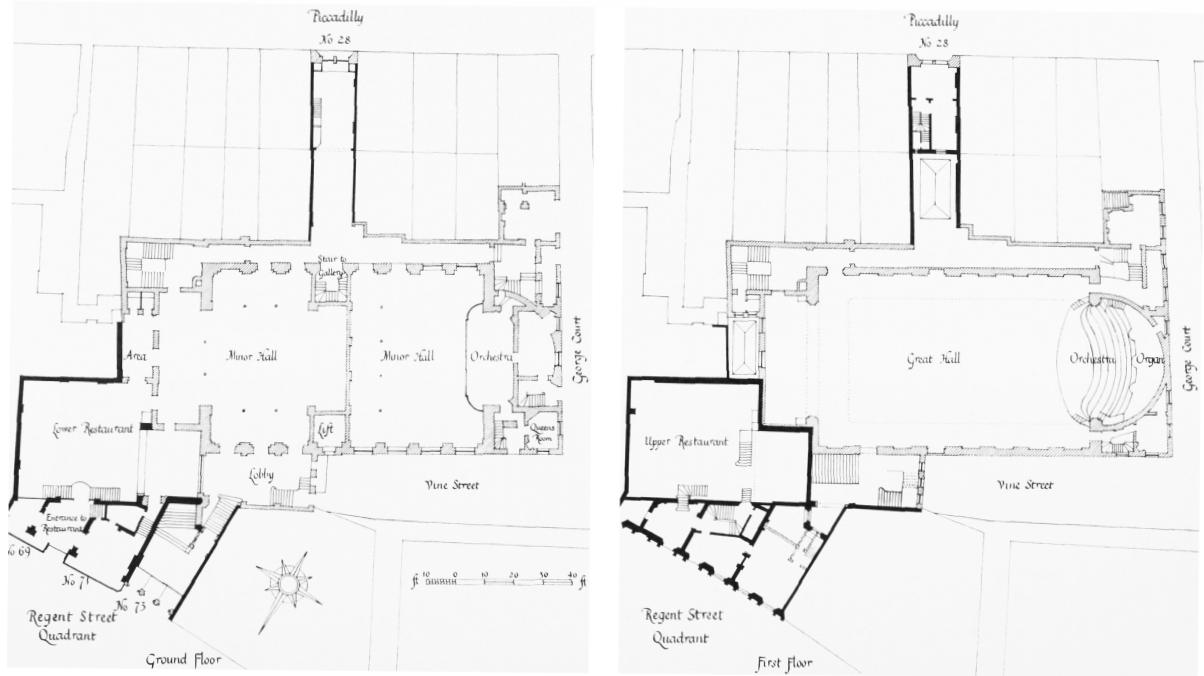
St. James's Hall, Piccadilly, ground- and first-floor plans. Redrawn from plans by Owen Jones in the Crown Estate Office
The narrow front towards Piccadilly, designed by Owen Jones, was a highly original composition, decidedly eclectic in style (Plate 30a). The twin doorways, and the two windows of the first and second floors, were recessed within a tall round-headed arch with a strongly moulded reveal. This arch was set in a plain face finished with a Graeco-Egyptian cornice and crested with anthemion ornament. The infilling of the arch was very elaborate, with 'Florentine' windows of cast iron, their arched heads springing from curiously detailed colonnets. Below the upper pair of windows were apron panels with a high relief decoration of putti, and in the tympanum of the arch was a relief symbolizing music.
Many famous musicians appeared at the St. James's Hall, including Dvorák, Grieg, Liszt, Paderewski, Saint-Saëns, Sullivan and Tchaikovsky. The acoustics of the building were extremely good, but the seats were uncomfortable and kitchen odours from the restaurant sometimes floated into the auditorium. Worse still, the sound of the Moore and Burgess Minstrels (who performed in one of the smaller rooms for over twenty years) could sometimes be heard upstairs in the main hall. (fn. 31)
The catering side of the business was greatly enlarged in 1874–5 by the acquisition and rebuilding of Nos. 24–26 (consec.) Piccadilly, with a street-frontage of some forty-five feet. The new building contained buffets, grill-and dining-rooms and offices, and could be entered from the concert halls. (fn. 32) The dining-rooms are said to have been 'notable as having been perhaps among the first in the metropolis to possess each a small kitchen of its own—an indispensable adjunct to hot and rapid service'. (fn. 33) The building was designed by Walter Emden and was in the Venetian Gothic style, the materials used for the Piccadilly elevation being red brick, Dumfries stone, red terra-cotta and mosaic on a gold ground. The general contractors were Lucas Brothers of Lambeth; the masonry and stone carving was by William Plows, the mosaics by Alexander Gibbs, and the terra-cotta by Messrs. Johnson and the Ditchling Potteries. (fn. 32) The Piccadilly front was four storeys high, not counting the mezzanine, and must have been very colourful with its wide variety of materials employed. The windows of the ground, first and second floors were grouped in pairs on each side of a single light, and all were dressed with slender colonnets and, apart from the ground-floor lights, with cusped arches. The third-floor windows were recessed behind a 'Ca'd'Oro' gallery.
The main entrance to the hall from Piccadilly was entirely rebuilt in 1882–3, with a slightly wider frontage. The architect was again W. Emden, whose designs on this occasion were 'after the Early English style, without any very strict adherence to old examples'. The front may more accurately be described as curiously French in character, with its trio of gabled doorways, and the high attic above the central feature, flanked by tourelles and crowned with a steep 'chisel' roof. The top of the building stood over a hundred feet above the pavement (Plate 31a). The contractor was Herbert Lea of Warwick Street. (fn. 34)
In 1885 the Metropolitan Board of Works decided that the hall was 'so defective in its structure that special danger from fire may result to the public frequenting the same', and therefore required the company to make thirty modifications, mostly in order to improve access. In 1899 the London County Council required a further twenty-nine alterations. (fn. 35) At about the same time the Council was also considering the widening of the north side of Piccadilly between the Circus and Sackville Street, and the company therefore decided to modernize their premises and make very extensive alterations. In 1901 the company signed an agreement with the Commissioners of Woods and Forests whereby it was to undertake heavy structural expenditure in return for a new lease of all its property. (fn. 36)
But the St. James's Hall no longer enjoyed its old pre-eminence in musical affairs—the Queen's Hall had been opened in 1893 and the Wigmore (then called the Bechstein) Hall in 1901—and it was probably not making a large enough profit to justify the high rent which the Crown would have demanded after the renewal of the lease. In 1903 the company therefore sold the benefit of their building agreement of 1901 with the Office of Woods to the P. and R. Syndicate, whose intention was to demolish the hall and erect a large first-class hotel. (fn. 37)
The St. James's Hall continued in use until February 1905, when it was demolished to make way for the Piccadilly Hotel (see page 87). (fn. 38)
The Great Room at No. 22 Piccadilly
Demolished
Between 1779 and 1809 there are occasional references to a public hall at the back of No. 22 Piccadilly. The building stood upon a small part of the site now occupied by Swan and Edgar's shop, and was later renumbered as 12 Piccadilly.
The Crown lease of Nos. 21 and 22 Piccadilly was renewed in 1767, and there was certainly no hall at that time. (fn. 39) In 1779 the rate assessment for No. 22 was increased from £60 to £82; the ratebook mentions 'backhouses' for the first time, probably in reference to the new hall.
During the winter of 1778–9 Philip Astley, the showman and circus proprietor, was roofing in his riding school at Lambeth, and during these alterations he hired 'the Large Room, No. 22 Piccadilly' for a temporary exhibition. Advertisements in the newspapers stated that the programme would include 'Ombres Chinoises, or Chinese Shadows. . . . Signor Rossignoll will play a Concerto on the Violin without strings; also imitate the Notes of Birds. . . . Likewise Mr. Astley will exhibit and discover tricks of Legerdemain; and the Horse and Dog will, by way of Prelude, perform as usual'. (fn. 40)
In c. 1785 the room appears to have been used as a chapel. In his history of dissenting churches, published in 1814, Walter Wilson mentions an auction room on the north side of Piccadilly which, some thirty years earlier, had been 'converted into a place of worship . . . by some persons of the Baptist persuasion'. Their minister, Joseph Gwennap, 'was very popular, and continued to preach there for several years with much apparent success', but in about 1798 'he was deserted by his flock, and the church in consequence became dissolved'. (fn. 41) (fn. 1)
From 1802 to 1808 the ratebooks list the hall as empty. The Microcosm of London contains an aquatint dated 1808 showing one of the sessions of the Debating Society, whose meetings were 'usually held in a large room at No. 22 Piccadilly, under the appelation of The Athenian Lyceum' (Plate 39b). (fn. 42) In January 1807 the Lord Chamberlain had given licence to 'Mrs. Henry to deliver lectures for her Benefit at the Athenian Lyceum, Piccadilly' on Wednesday evenings. (fn. 43)
In 1809 William Bullock removed his museum from Liverpool to 'the Great Room, No. 22 Piccadilly, London, Which has been fitted up for the Purpose in a Manner entirely new'. (fn. 44) The collection probably remained there until its removal to the Egyptian Hall in 1812. (fn. 45)
The Crown lease of No. 22 Piccadilly expired in 1817, (fn. 46) and with the formation of Regent Street the hall ceased to exist shortly afterwards.
Swallow Street
Swallow Street is first mentioned in the ratebooks in 1671, (fn. 47) when building began in Swallow Close, which takes its name from its sixteenth-century tenant, Thomas Swallow. Ogilby and Morgan's map of 1681–2 (Plate 3a) shows that its course had been extended northwards into Mulghay Close or Dog Field, at whose northern boundary it joined the western extremity of Beak Street. The latter formed part of the ancient highway which is marked on the plan of 1585 as leading (in the terms of the modern layout) from Piccadilly Circus to Oxford Circus. When building continued northward from Beak Street along this highway it, too, became known as (Great) Swallow Street, which until the formation of Regent Street was an important avenue of communication between Piccadilly and Oxford Street. The greater part of the site of Swallow Street is now taken up by Regent Street, and only the short stretch between Piccadilly and the Regent Street Quadrant still survives. (fn. 2)
By 1691 some 117 yards of its course were 'adjudged fit to be paved with stone', (fn. 48) and in 1720 Strype described it as 'very long, coming out of Pickadilly, and runneth Northward to Tyburn Road, against Neb's Pound, but of no great Account for Buildings or Inhabitants'. Stables and coach-houses abounded; a little north of Beak Street 'this Street endeth, and falleth into a lane that leadeth to the high Road'. (fn. 49) Northwards from the backs of the houses on the south side of Conduit Street it formed the boundary of the parishes of St. James and St. George, Hanover Square, and Rocque's map of 1746 shows that building here had been completed.
During its rebuilding in 1801–4 the Scots chapel on the west side of Swallow Street opposite Little Vine Street was re-aligned (see below), and John Fordyce, the Surveyor General of the Crown's Land Revenue, obtained the authority of the Treasury to take down the four houses between the chapel and Piccadilly in order to widen the street. This improvement appears to have been carried out in or soon after 1815, the width of the street at its junction with Piccadilly being increased from only 17 to 30 feet. (fn. 50)
Scottish Presbyterian Chapel, Swallow Street
Demolished
In the early months of 1694 it appears to have become clear to the French Protestant congregation in York Street, St. James's Square, that they would have to find other accommodation. At a meeting on 7 March, the ministers and elders decided that a new chapel should be built, to be financed initially by the ministers, who would be repaid later out of collections and pew-rents. At what seem to have been the final meetings in York Street, on 8 and 9 April, plans were prepared for the removal of certain fittings, regarded by the church as its personal property, and allowed to them by Lord Dover, the ground landlord.
The new church was opened on 1 July 1694, having been built at a cost of £348 1s. 2d. (fn. 51) The site on the west side of Swallow Street (now occupied by Nos. 7 and 9) was held on a lease for thirty-five years. In addition, it included a narrow strip of Pulteney property along its western side. (fn. 52) The buildings seem to have included a chapel of about the same size as that in York Street, and an adjoining house, perhaps intended as church offices or a school. (fn. 51) The church now seems to have adopted the name L'Eglise de Piccadilly, the title formerly used by the Glasshouse Street French church (fn. 53) (see page 341).
The French congregation does not seem to have prospered in its new home (fn. 51) and by 1707 its membership had declined to such an extent that in November the consistory was united to that of Le Quarré in Berwick Street (fn. 54) (see page 225). Nevertheless, the church carried on in Swallow Street for a further two years. The last entry in its registers is dated 11 August 1709, (fn. 55) and in February 1709 (?/10) the lease of the property was bought by the congregation of Scottish Presbyterians which then occupied the chapel in Glasshouse Street. (fn. 56)
The minister, Dr. James Anderson, collected a large congregation in what was described by a contemporary writer as 'a part of the town where Dissenters are very little in fashion'. (fn. 57) Their number included the members of Richard Baxter's former meeting-house in Swallow Street (fn. 58) (see below). In 1729 the church was described as 'a Slight Building, much out of Repair', (fn. 59) but it is said to have been rebuilt before 1734, when a new Crown lease was granted. (fn. 60) In the same year, after a disagreement within the church, Dr. Anderson left Swallow Street with part of the congregation. They settled in Lisle Street, and this group later established the Scottish Church in Peter Street (fn. 57) (see page 228).
The Crown lease was renewed in 1769 by the remaining members of the church, (fn. 61) but in 1796 there was another split. Part of the congregation followed Thomas Stollerie, the assistant minister, to the former French Church in Chapel Street, Soho, where they established themselves as Independents. (fn. 62)
In 1798 the minister, Dr. John Trotter, began negotiating with the Crown for the grant of a ninety-nine-year lease 'with a view to rebuild the Premises, which have long been in a decayed State, and only kept from falling by the Galleries'. The existing building stood some way back from the street, and was approached by a passage through a house which stood in front of the south end of the chapel, while the north end was masked by a stable and coach-house. On the advice of John Fordyce, Surveyor General of the Crown's Land Revenue, the congregation acquired the leases of these premises, and in 1801–4 a new and larger chapel was built, in line with the rest of the street-frontage. The architects were probably Fordyce's assistants, John Marquand and Thomas Leverton, who included the design for the elevation to the street in the report which the Surveyor General directed them to prepare. (fn. 3) A ninetynine-year lease commencing in 1801 was granted in 1804. (fn. 63) The new building contained three galleries, and was 'fitted up with great neatness'. (fn. 58)
For a time the church flourished, but in the 1840's it was disturbed by the Free Church secession movement in Scotland. The congregation appears to have remained within the established Church of Scotland, but it now seems to have suffered increasingly from the shift of population to the suburbs. In 1880, despite the protests of those members still living in the area, the lease was sold to Colonel Somers Lewis of the 4th Middlesex Rifle Volunteers. By the autumn of 1880 the building had been converted into a drill hall, the architect being J. M. Brydon of 98 Gower Street. The two side galleries were removed at this time.
In 1885 Colonel Lewis sold the lease of the property to a congregation of the Theistic Church, led by the Rev. Charles Voysey. It was altered and refitted for their use by C. F. A. Voysey of Broadway Chambers, Westminster. His work included the removal of the upper gallery, the insertion of 'Cathedral glass' in all windows, 'painting, papering and colouring throughout', and a new entrance at the north end of the façade.
The Theistic Church obtained a new lease of the property in 1898, and the building was again repaired by C. F. A. Voysey. (fn. 63) The spire was removed in or shortly after 1901. (fn. 64) The lease was surrendered to the Crown in 1915, (fn. 65) and the church was demolished during the summer of that year. The erection of a block of show-rooms and offices on the site was completed in the following year. The architects were Messrs. Trehearne and Norman and the builders John Marsland and Sons. The new premises were first known as No. 23 Swallow Street, but later became Nos. 7 and 9 Swallow Street. (fn. 66)
No. 12 Swallow Street
Formerly the Swallow Music Hall
References to a music hall in this street probably relate to a concert room at the Goat and Star public house which formerly stood at the north-east corner of Swallow Street and Piccadilly Place (formerly Little Vine Street). (fn. 67) In 1889 the London County Council required the landlord in the interests of public safety to make substantial alterations, and in the following year the Goat and Star was completely rebuilt on a slightly enlarged site; the name was changed to the Swallow. The new building, which was designed by Robert Sawyer, again incorporated a concert hall. (fn. 68) In 1919 it was bought by a commercial firm for use as offices, and the licence was discontinued. (fn. 69)
Swallow Street Chapel
Demolished
In A Breviate of the Life of Margaret . . . Baxter, published in 1681, Richard Baxter describes his wife's attempts to establish a chapel for him in Oxenden Street. When these were frustrated by the authorities, she hired another chapel 'ready built, for gain' in Swallow Street, 'that the poor people where I had begun . . . might still be taught'. But here too he was prevented from preaching 'by the Officers standing at the door with the Justices Warrant Many Months together'. (fn. 70) Mrs. Baxter at last accepted the fact that the authorities were objecting to her husband rather than to the chapel itself, and she therefore found 'a faithful painful self-denying man' to occupy the pulpit. The arrangement seems to have been a success, for in 1681 Baxter wrote that the minister of the chapel had 'there done much good, and still doth'. (fn. 71)
According to Walter Wilson, Baxter began his attempt to work in Swallow Street in April 1676. The name of his successor is not known, but later ministers included Joseph Hill and a Mr. Carlisle until 1699, and then a Mr. Stort, who was thought to have died in about 1710. The congregation broke up, the greater number of them joining Dr. James Anderson's Scottish Church, then newly moved to the same street (fn. 58) (see above).
The site of Baxter's chapel is not known, but Strype, writing in 1720, perhaps provided a clue when he mentioned Baxter's Yard (on the east side approximately on the site of the northern part of the Regent Street Quadrant), which was then 'being made Use of by one Mr. Baxter, who there kept his Riding-house, for the instructing young Gentlemen to ride the managed Horse'. (fn. 72)
Vine Street
Rocque's map of 1746 (Plate 6) shows Vine Street as a narrow continuation of Warwick Street extending southwards towards Piccadilly. The origin of the name is not known but it may well have been derived from the Vine public house which existed here in the eighteenth century and very possibly earlier. (fn. 73) The street appears to have been laid out in 1686–9 (fn. 74) and Strype recorded that in 1720 most of one side was taken up by a brewhouse and the other by a carpenter's yard. (fn. 72)
Vine Street was bisected by the building of Regent Street in 1816–19. The northern part, which was subsequently known as Great Vine Street or Warwick Street, ceased to exist when the Quadrant was rebuilt in the 1920's. The northern opening is marked by the north end of Brown's Arcade, but the rest of the arcade is on a different alignment. To the south of Regent Street only a vestige of Vine Street survives as the narrow passage between Regent Street and Piccadilly Place, now called Man in Moon Passage—a name derived from the public house which stood on the corner of Little Vine Street.
Peter Scheemakers, the Dutch sculptor, occupied premises on the west side of the street from 1741 or 1742 until his return to Antwerp in 1769. (fn. 75)
The Court of Request
Demolished
In 1750 an Act of Parliament established Courts of Request for the recovery of small debts in Westminster and part of the adjoining Duchy of Lancaster. (fn. 76) The Act made no provision for buildings for the courts and was defective in other ways. It was therefore amended in the following year and the area with which it dealt was divided into two divisions, each with its own court house. (fn. 77) One of these was built in 1751–2 on the west side of Vine Street, next to the house on the corner of Little Vine Street (now Piccadilly Place); (fn. 74) it was apparently a two-storeyed building with a sub-basement. (fn. 78)
In 1836 the court house was closed when the area of jurisdiction of the Westminster courts was changed. (fn. 79) It was subsequently occupied by Edward Gaffin the statuary, whose firm 'poured forth an apparently unceasing flood of tame, dull and uninteresting monuments'. (fn. 20)
The lease of the building was assigned in 1850 to the Receiver of the Metropolitan Police District and incorporated in Vine Street Police Station (see below).
Piccadilly Place
Piccadilly Place is a T-shaped street. The north-south arm was originally known as Meggott's or Maggott's Court after the Meggott family which held ground there on lease from the Crown. (fn. 80) It was subsequently known as George Court, and was renamed Piccadilly Place in 1862. The westeast arm connecting Swallow Street and the south end of Vine Street, was originally known as Little Swallow Street and first appears in the ratebooks of St. Martin's in 1675. Rocque's map of 1746 marks it as Little Vine Street, but after the formation of Regent Street in 1816–19 it became known as Vine Street. In 1940 it was renamed Piccadilly Place.
Aliens' Registration Office
Site formerly occupied by the watch-house, Offertory School and Police Station
Soon after the constitution of the parish in 1685 a watch-house was built in the churchyard of St. James's Church. A boys' charity school was established at about the same time, and was maintained out of the offertory money; hence its usual appellation of the 'Offertory' school. For many years after 1704 the school occupied a room over the watch-house. (fn. 81)
By the 1760's the watch-house was no longer large enough. Matthew Fairless, carpenter, acting on behalf of the parish, purchased a house on the north side of Little Vine Street, (fn. 82) to which, after some alterations had been made in 1767, (fn. 83) both the watch-house and the school were removed. (fn. 84)
In 1786 a fire destroyed several houses in Swallow Street, Vine Street and Little Vine Street, including the watch-house. (fn. 85) This was rebuilt in 1786–7 under the supervision of William Gowan. (fn. 86) A later survey of the building shows that it had a basement in which the watch-house keeper lived and where there were two arched cells for 'the custody of either sex'. On the ground floor was a watchmen's room, a room for 'the Beadle and Constable of the Night', with a small lock-up room behind. The whole of the upper storey consisted of one lofty room for the Offertory School over which, in about 1816, another storey was added for the use of the schoolmaster. (fn. 87)
Under the provisions of the Act of Parliament of 1829 which established the Metropolitan Police District, the watch-house became known as Vine Street Police Station. The school remained there until 1836, when the rector obtained a lease of Nos. 7 and 8 Swallow Street (round the corner from the police station) and a school was erected on the site. It was eventually closed in 1881, though part of the premises was used for some years for a Sunday school and other parochial activities. (fn. 88)
The police station remained in (Little) Vine Street from 1829 until the building of a new station in Savile Row in 1939–40. During this period it gradually absorbed almost all the buildings on the north side of the street. (fn. 89) In 1850 the leases of No. 11 (Little) Vine Street and the former Court of Request in Vine Street were purchased by the Police Receiver and added to the station for use as a section house. (fn. 90) No. 9 was added to the section house in 1856 (fn. 91) and No. 12 in 1860. Rebuilding of all these premises took place in 1869. (fn. 92)
In 1897 the school building at Nos. 7 and 8 (now No. 14) Swallow Street was purchased (fn. 93) and in 1897–9 the station was largely rebuilt by Messrs. Lathey Brothers. (fn. 94) The Man in the Moon public house at the eastern extremity of (Little) Vine Street was purchased by the Police Receiver in 1931. (fn. 95) In 1940 the police station was removed to new premises in Savile Row and the old building was re-opened in the same year as the Aliens' Registration Office.
Air Street
'Aire Street' (which in its southern part follows the boundary of Swallow Close and Round Rundles) first appears in the ratebooks in 1658, its name being presumably derived from Thomas Ayres, brewer, who held leases in the neighbourhood. The northern part of the street formed the western boundary of the Sherard estate, and was sometimes referred to as Francis Street, probably after Francis Sherard. The St. Albans rent-roll of 1676 mentions twenty-three houses in the street. (fn. 96)
Air Street is now arched over at first-floor level by the buildings on the north and south sides of the Regent Street Quadrant, which cuts across the street near its southern end.
In 1803 there was said to be a nonconformist chapel in this street. (fn. 97)
Glasshouse Street
Glasshouse Street is marked on Ogilby and Morgan's map of 1681–2 (Plate 3a) as extending westward from the south end of Warwick Street towards the northern boundary of the garden of Burlington House; a map of 1720 (Plate 5) shows that it stretched as far west as Bond Street. Rocque's map of 1746 (Plate 6) and Horwood's of 1792 show the western portion between Savile Row and Bond Street as Vigo Lane. This part of the street subsequently became known by its present name of Burlington Gardens, and with the formation of Regent Street in 1816–19 the portion between Savile Row and Regent Street became known as Vigo Lane or Street. Thus only the very short portion between Regent and Warwick Streets was still known as Glasshouse Street. But in 1863 both Marylebone and Tichborne Streets were renamed as part of Glasshouse Street. This section is concerned with the modern Glasshouse Street, of which only a very small portion formed part of the seventeenth-century street of that name.
Glasshouse Street first appears in the ratebooks in 1678, (fn. 98) and perhaps owes its name to the activities of Windsor Sandys in this neighbourhood. His name appears as a ratepayer for a tenement 'in the Fields' to the north of Piccadilly between 1675 and his death in 1680; (fn. 99) (fn. 4) in 1675 and 1678 he also paid rates for a large area of land including 'Crab-Tree ground', of which Glasshouse Street was the southern boundary. It is known that in 1676 Sandys was the partner of John Dwight, the Fulham potter, and in that year they contracted to supply stoneware to the Glass Sellers' Company. (fn. 100) As early as 1672 Sandys had been general undertaker for cleansing the streets of the parishes of St. Martin and St. Giles, (fn. 101) and it may be conjectured that he used the potassium nitrate, or saltpetre, which was produced from night soil, as an ingredient for the production of glass. In 1693 a complaint was made on behalf of Lord Burlington to the vestry of St. James about 'the place erecting behind the said Earles house and Garden for the making of Salt Peter', (fn. 102) and in 1694 there was another complaint 'about the Place behind his Lordship's House and Garden where they shoote the Night Stuffe and Boyle for Salt Peter'. (fn. 103) These activities may well have been started in the 1670's by Sandys; taken in conjunction with his association with Dwight this evidence, although inconclusive, provides a likely explanation for the name 'Glasshouse Street'.
Warwick Street and the modern Glasshouse Street mark part of the course of the highway delineated on the plan of 1585 (Plate 1) as leading (in terms of the modern layout) from Piccadilly Circus to Oxford Circus. Until the eighteenth century the southern portion of this highway was known as Shugg Lane (Shrug, Sugg, etc.) and is referred to as Suggen Lane in deeds of 1391. (fn. 104) (fn. 5) It formed the boundary between Windmill Fields on the north and Swallow Close and Round Rundles on the south. Building seems to have begun soon after the Restoration, and the St. Albans rent-roll of 1676 mentions some seventeen houses on the south side. (fn. 96) In 1720 Strype described it as 'but meanly built, neither are its Inhabitants much to be boasted of'. (fn. 72) Horwood's map of 1792 designates the southern portion of the lane Tichborne Street, a name derived from the Tichborne family, which owned property on the north side. On all seventeenth- and eighteenth-century maps the northern portion of the street, between Warwick and Sherwood Streets, is described as Marybone or Marylebone Street, but (as has been mentioned above) in 1863 both Marylebone and Tichborne Streets were incorporated in Glasshouse Street.
In May 1796 John Fordyce, Surveyor General of the Crown's Land Revenue, informed the Treasury 'that the street called Tichborne-street (late Shug-lane) with part of Marybone-street (being a principal avenue from the middle and lower parts of the town to Golden-square, Hanover-square, Oxford-street, and the numerous Streets and Squares in this vicinity, and forming a part of the most direct communication from the Houses of Parliament and Westminster Bridge, to the principal streets in the upper part of Marybone) is at present very narrow and incommodious, so as not only to occasion frequent stoppages of carriages, and other inconveniences, but likewise to affect the value of the property.' He emphasized the need to widen the street, and shortly afterwards the Treasury granted him the necessary authority. (fn. 105) A plan drawn up for Fordyce by John Marquand and Thomas Leverton shows that twenty-nine houses on the south side of Tichborne and Marylebone Streets were to be set back; the leases of nine of them had already expired, but in five cases there were still over thirty years to run. (fn. 106) Progress was therefore slow, and in 1812, when the leases of three houses at the south end of the street were about to expire, the scheme—one of the earliest improvements to be made on the London estates of the Crown—had evidently not yet been fully completed (fn. 107) (Plate 136a).
When Regent Street was formed an opening was made from the south-east end of the Quadrant into Tichborne Street, leaving to its south a triangular island of buildings fronting north-east on Tichborne Street and south-west on the new Piccadilly Circus (or Regent Circus South, as it was originally called). This island block was subsequently acquired from the Crown by the Metropolitan Board of Works for the formation of the south end of Shaftesbury Avenue, and its site was incorporated in the enlarged 'Circus' (fig. 8). But the buildings on the north-east side of Piccadilly Circus, and now numbered 2–8 (even) Glasshouse Street and 44–48 (even) Regent Street, still stand on the unaltered northeast line of Tichborne Street, and therefore, presumably, of the medieval Shugg Lane. The diagonal course of Glasshouse Street in relation to much of the modern street layout, and its oblique entry into Piccadilly Circus have proved two of the greatest difficulties confronting twentieth-century attempts to replan the Circus to an improved design.