A History of the County of Hampshire: Volume 5. Originally published by Victoria County History, London, 1912.
This free content was digitised by double rekeying. All rights reserved.
'Winchester: Hyde abbey', in A History of the County of Hampshire: Volume 5, (London, 1912) pp. 20-21. British History Online https://www.british-history.ac.uk/vch/hants/vol5/pp20-21 [accessed 24 April 2024]
HYDE ABBEY
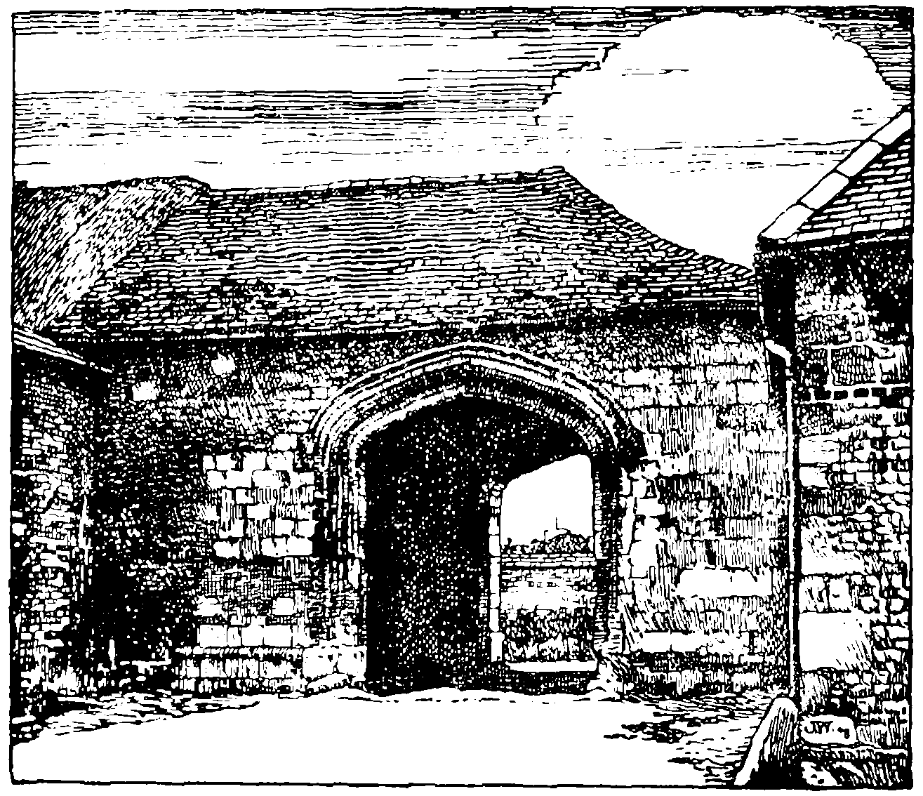
Winchester: Hyde Abbey Gateway
In the most northerly of the old suburbs of the city, St. Bartholomew, Hyde Street, the old Roman road to Silchester, running north from where Jewry Street meets the North Walls and City Road, passes west of the site of Hyde Abbey. There is a red brick house in Hyde Street of early 17th-century date. It faces north and south at right angles to the street, and has been partly rebuilt, all the windows being mid-18th-century insertions. Some original openings are still visible, however, and appear to have held wooden mullioned sashes. The end to the street has a curved gable coped with moulded brick and a moulded brick cornice. At the ground level is a blocked door with a pilastered Doric entablature all in brick.
The gate-house of Hyde Abbey is a rectangular stone building of 15th-century date 30 ft. 3 in. by 22 ft. 2 in. internally, facing north-east by north. The entrance passage occupies the right or west side of the building, the east side being of two stories with a vice in the south corner, entered by a small door from the abbey precincts, which still remains, though the vice has been almost completely destroyed. The passage is spanned by two wide four-centred arches, the outer being of two moulded orders separated by a hollow with a rebate for the doors on its inner face. The inner arch is of plainer character, with a single chamfer, and is not arranged for a door. The passage does not seem to have been vaulted, and it is doubtful if there was ever more than a partition between the passage and the east rooms, which were doubtless the porter's lodging. In a westerly direction from the gateway are some farm buildings, apparently a part of the abbey, but such fragments of detail as remain are all much defaced. Adjoining the gateway is a barn which appears to be largely built of old stonework, and at the other end of this are a few old walls containing a couple of small square-headed loopholes with much defaced splays and rear arches. Eastward of the gateway is a small stream running north and south, over which is a small footbridge with a segmental arch largely built of 12th-century stones and containing a fragment of cheveron ornament. North of this the stream is again spanned by a thick rubble wall on a rough arch. Within the area covered by the abbey grounds are numerous barns and outbuildings largely built of old stones.
There are some fragments of the abbey buildings preserved in St. Bartholomew's Church close by. These consist of five capitals of very rich design. In the case of three each face has a circular medallion with elaborate floral designs, dragons, and in one instance cherub heads; also a double skew-back, one side of which has the cheveron ornament and the other a pellet and leaf ornament and an edge roll.
North of the site of the abbey in the meadows on the way to the Worthies is Abbot's Barton Farm, the manor farm of the Abbot of Hyde's manor of Abbot's Barton. Within the last few years the meadow land between the site of the abbey and the Abbot's Barton Farm has been let out for building, and the result is a new colony of small modern semidetached villas still spreading to the north. The swampy land east of this site has been drained at the ratepayers' expense and turned into a flat, uninteresting public park. West of the city the suburb of Fulflood has increased in the same way within the last twenty years, the side roads branching north and south from the Upper Stockbridge Road being lined with modern cottages and villas. South of the Upper Stockbridge Road is the workhouse, south of which again is Oram's Arbor, where until the 19th century the freemen met to choose their member for Parliament. There has lately (1908–9) been some controversy concerning the use of the Arbor as a public recreation ground.
South-east of Oram's Arbor at the junction of Upper High Street and Sussex Street is an obelisk erected in 1759, on the site of an early processional cross, to commemorate the plague which had raged in the city in 1666. It was to this spot that the peasants of the surrounding country had brought food for the citizens, who carried it away after the peasants had left, leaving payment for the same in a bowl of vinegar to avoid infection. (fn. 1) The county police station and the county gaol are on the north side of the Romsey Road, the Roman road which goes out from the Westgate to Salisbury, the Royal County Hospital being on the opposite side of the road a few yards west of the gaol.