A History of the County of Gloucester: Volume 4, the City of Gloucester. Originally published by Victoria County History, London, 1988.
This free content was digitised by double rekeying. All rights reserved.
'Gloucester, 1720-1835: Topography', in A History of the County of Gloucester: Volume 4, the City of Gloucester, (London, 1988) pp. 159-169. British History Online https://www.british-history.ac.uk/vch/glos/vol4/pp159-169 [accessed 12 April 2024]
Topography
During the 18th century Gloucester's unspectacular economic performance was matched by the lack of physical growth. There was some new building in the inner part of Barton Street. (fn. 1) Houses just beyond the city boundary there were advertized in 1736 as advantageous for tradesmen, who could conduct their business without taking the freedom, (fn. 2) and soon after 1763 the woolstapler James Helps built new houses and workshops some way beyond the boundary adjoining the later Charlton House. (fn. 3) That and other new building led to the moving of the turnpike further out, to the junction with Barton Lane, c. 1779. (fn. 4) For the most part, however, the roadside suburbs destroyed in 1643 were not replaced: the earliest detailed map of the city, in 1780, showed only a few scattered houses on the London road, while Brook Street and Severn Street remained empty of buildings. (fn. 5) The modest population increase of the 18th century was accommodated mainly by subdividing existing buildings, including parts of Greyfriars and Blackfriars, (fn. 6) and by occasional new building on available waste land within the city. A new house was built before 1732 just beyond the east gate on the site of a former horsepool, (fn. 7) and after the demolition of the gate and adjoining buildings in 1778 new houses were built on the north and south sides of the street there; (fn. 8) a piece of waste on the south side of the Foreign bridge, adjoining Dockham ditch, was filled by three houses c. 1744; (fn. 9) and c. 1802 the bricklayer Daniel Spencer built a row of nine cottages on the culverted river Twyver on the north side of St. Aldate Street. (fn. 10)
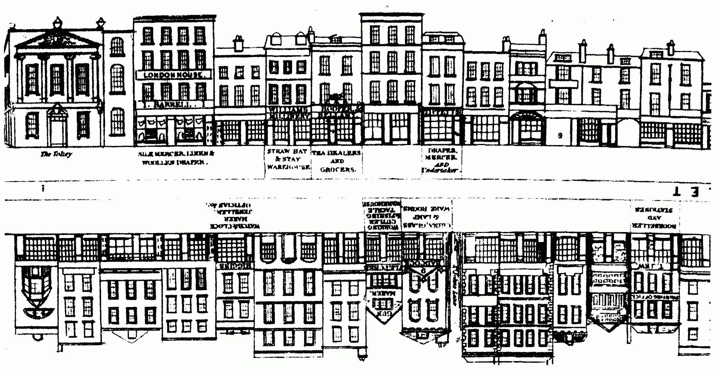
Upper Westgate Street, c. 1841: the south side (at the top) includes the Tolsey
The failure of the city to expand puzzled some of its citizens. 'While whole streets are building in other places, scarcely a single house rears its head in this' wrote one in 1792. He apparently attributed it to lack of initiative, refuting a popular view that the high proportion of leasehold, under the dean and chapter and the city corporation, was the main deterrent to new building. He pointed out that with chapter property, which was held on 40-year leases renewable every 14 years at a fine estimated at a years' value, the first renewal after any improvement was usually allowed at the old value. (fn. 11) Similarly the corporation in an attempt to encourage new building as early as 1729 had offered the holders of its 41-year leases the chance of taking new leases at 1¼ years' value and renewing them after 14 years at the old rate. (fn. 12) When the necessary incentives for growth appeared after the Napoleonic Wars some of the new building, for example on hospital property in the London road, did take place on leaseholds. (fn. 13) Nevertheless expansion was helped by the fact that much of the land immediately adjoining the city, including Monkleighton grounds and Gaudy Green, had been sold by the chapter and the corporation for land-tax redemption in 1800. (fn. 14)
The old city did, however, change its appearance considerably during the mid and later 18th century. Rebuilding and refronting in brick continued in the main streets and in the cathedral close. (fn. 15) Most of the timber houses had gone or been masked by c. 1770 when the city was said to be built mainly of brick. (fn. 16) The new fronts of the mid 18th century were generally rather plain, decoration being limited to a dentilled cornice and perhaps keystones to the windows. (fn. 17) A few were more elaborate. Bearland House, in Longsmith Street, which was enlarged and refronted for an attorney William Jones, (fn. 18) and no. 100 Westgate Street both have details copied from the pattern books of Batty Langley. (fn. 19) Nos. 29 and 31 Southgate Street, later the premises of the Saunders family of wine merchants, (fn. 20) share a pedimented doorway, above which is a venetian window from a pattern book of W. and J. Halfpenny. (fn. 21) Other such details were presumably lost when shop fronts became ubiquitous in the main streets in the early 19th century. (fn. 22)
One street front which stood out, both for its architectural distinction and for the fact that it was in ashlar, was on a house on the north side of lower Westgate Street, which was rebuilt by Anthony Freeman soon after he bought it in 1724. (fn. 23) Called Eagle Hall in 1801, it was later known as Old Spa House, for a medicinal spring in its garden was briefly fashionable in the 1780s. Popularly it also because known as the Duke of Norfolk's House, Charles Howard, duke of Norfolk (d. 1815), having lodged there when visiting the city to cultivate his political interests. (fn. 24) The front was of three storeys and of five bays between Corinthian pilasters. The ground-floor windows had segmental pediments and those on the first floor triangular pediments; the parapet carried a large eagle and four urns. (fn. 25) The quality of the design suggests that it was the work of a Bristol or London architect.
Other fronts of a more architectural flavour added to the streets in the period were those of the public buildings and chief inns, including the Boothall inn of c. 1742, the Tolsey of 1751, (fn. 26) the Eastgate market portico of 1786, (fn. 27) and the long pedimented front of the Bell, probably of 1793. (fn. 28) The rise of banking gave its first notable addition to the street frontages c. 1801 when the firm of Fendall, Evans, and Jelf built premises in upper Northgate Street. (fn. 29) With its rusticated ground floor, pilastered upper floor, and balustraded parapet, the bank was very similar in design to the new Bluecoat school in Eastgate Street (fn. 30) built in the years 1806–8 and was possibly by the same architect, John Wheeler. (fn. 31)
Away from the main streets, one of the more imposing new houses of the period was Constitution House, at the east end of Bell Lane, built by a woolstapler, Richard Chandler, in 1750. (fn. 32) In the late 18th century and at the start of the 19th some large new houses were added around Greyfriars (fn. 33) and on inner Barton Street, where the barrister and banker William Fendall built an ashlar-faced, bow-fronted mansion (later Mynd House) c. 1800. (fn. 34)
Apart from the central area around the Cross, the city retained a fairly uncongested character until the early 19th century with large expanses of garden behind the houses. (fn. 35) Some gardens were highly ornamental in character. That behind Anthony Freeman's house in lower Westgate Street had an octagonal summer house with a painted ceiling in 1736, and in the 1740s Benjamin Hyett laid out a Chinese-style garden on the castle grounds behind Marybone House, including serpentine walks and a pagoda on a mount. An even more elaborate garden was formed by the physician Charles Greville at the house at the entrance to Barton Street (later Elton House) which he occupied by 1749; it included summer houses, arbours, and a central obelisk on a mount. (fn. 36) The more conventional style of landscape gardening was later represented in the city on a small scale. By 1780 John Pitt, owner of Paddock House in the later Pitt Street from 1758, had laid out a small park, including an ornamental pond, on land between the house and St. Catherine Street, (fn. 37) and in the early 19th century the former bowling green and adjoining land in the south-east angle of the city walls was planted by the owners of Bowling Green House. (fn. 38)
During the second half of the 18th century alterations were made to the city's main streets as the increase in wheeled traffic demanded thoroughfares uncluttered by obstacles and projections. Under an improvement Act of 1750 the buildings in the centre of Westgate Street, including Holy Trinity church tower and the King's Board, were removed, together with the high cross and some buildings in Northgate and Southgate Streets. (fn. 39) Other projecting buildings and obstructions were removed under an Act of 1777, which also enforced the repaving of the main streets and other improvements, such as the provision of guttering to the houses. (fn. 40) The city's east gate was taken down in 1778 and several of the other gates in 1781, (fn. 41) when further regulations were made for improving the state of the streets. (fn. 42) The entrance to Hare Lane, then the main Tewkesbury road, was widened in 1779; (fn. 43) the main road out to the west was widened in the 1780s when St. Bartholomew's Hospital in the Island was rebuilt; (fn. 44) and the entrance to Lower College Lane was widened at the joint expense of the corporation and dean and chapter in 1794 or 1795. (fn. 45) In 1786 the opening of new market places, off Eastgate Street and Southgate Street, removed the produce markets and butchers' shambles from the streets. (fn. 46) In the gradual modernisation of the city and its public buildings an important landmark was the removal of the old castle keep near the quay in 1787 to make way for the building of a new county gaol on model lines. (fn. 47) Another imposing medieval feature, the west gate, was demolished c. 1805 and the ancient bridge on which it opened was rebuilt a few years later. (fn. 48) The Boothall, the old timber-built county hall behind the Boothall inn in Westgate Street, remained in use, a picturesque but increasingly inconvenient survival, until 1816 when a new Shire Hall with a dignified classical street front was opened on an adjoining site. (fn. 49)
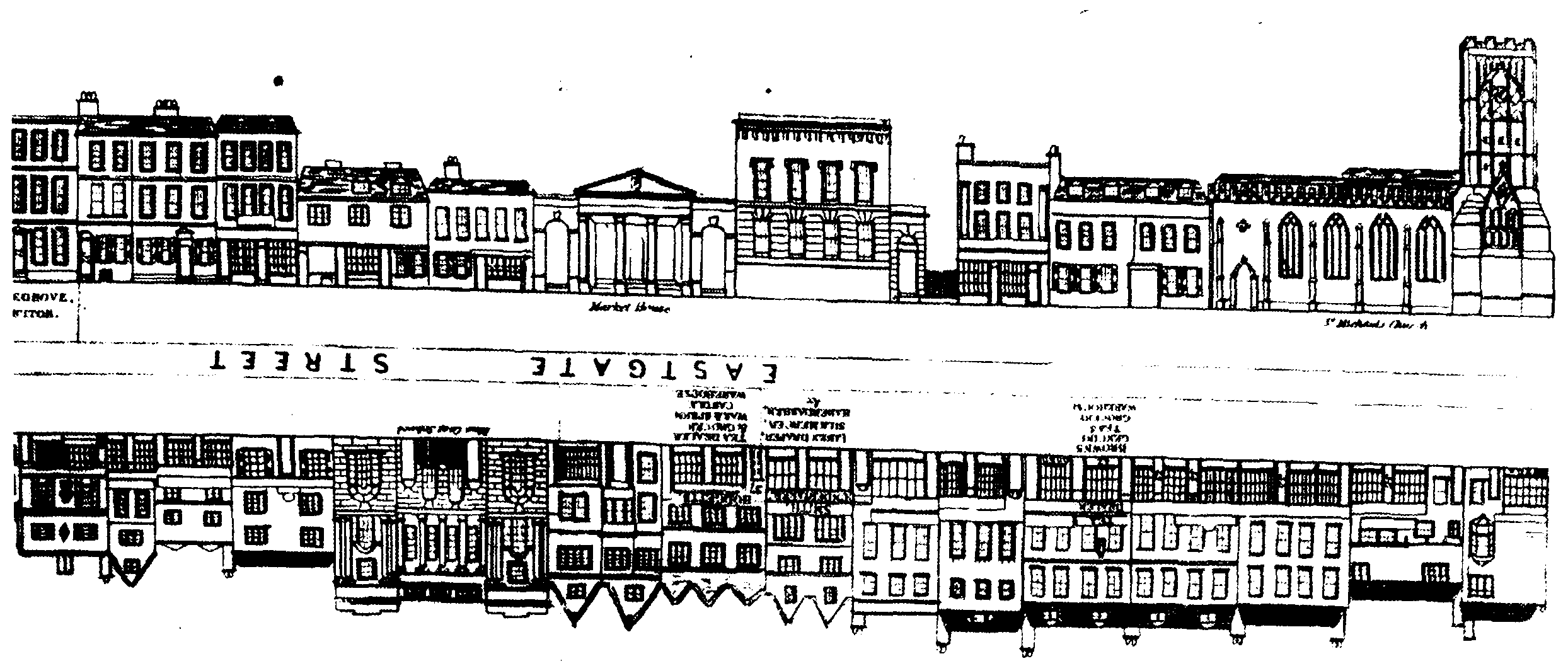
Upper Eastgate Street, c. 1841: the south side (at the top) includes St. Michael's church, the market portico of 1786, and (west of the portico) the premises of the Gloucestershire Banking Co.
In a history of the city published in 1811 the Revd. Thomas Rudge applauded the effect of the late 18th-century street improvements, recalling a time when 'the whole north side of St. Michael's church was hid from view, by mean houses or shops; the rain dropped from the eaves of the buildings, directly on the heads of those who passed under; the butchers… slaughtered their beasts in public view, and the blood running down the open gutters, afforded a most filthy and nauseous spectacle; the pavement was incommodious to foot passengers, and the main street equally so for carriages and horses…'. (fn. 50) To the more antiquarian-minded Revd. Thomas Fosbrooke, however, early 19th-century Gloucester was 'merely a mutilated figure of its antique picturesque glory. The statue has been stripped of its limbs, such as were various churches, the castle, religious houses, walls, etc. Only the fine bust, the cathedral, remains partially unimpaired'. (fn. 51)
At the close of the Napoleonic Wars a period of expansion began for the city. One incentive was the better economic prospects provided by the revival of the scheme for the Gloucester and Berkeley canal. The canal basin, on the south side of the city, adjoining the river, had been dug in the 1790s, its construction involving the severing of the old Severn Street and the building of Llanthony Road as a link between the Bristol road and Hempsted Lane. The basin was opened in 1812 and, connected to a horse tramway from Cheltenham completed the previous year, (fn. 52) began the transformation of that part of the city into its main industrial quarter. A parallel stimulus was the exploitation after 1814 of medicinal springs on Rigney Stile grounds east of the Bristol road. New building on the fringes of the city reached a peak of activity in the early 1820s when the columns of the Gloucester Journal carried many notices of the sale of building plots, (fn. 53) surveyors and architects advertised their services, (fn. 54) and the city corporation actively encouraged the process by offering building leases free of any fine at the first renewal. (fn. 55) New building was checked by the slump of 1825 but began again in the late 1820s.
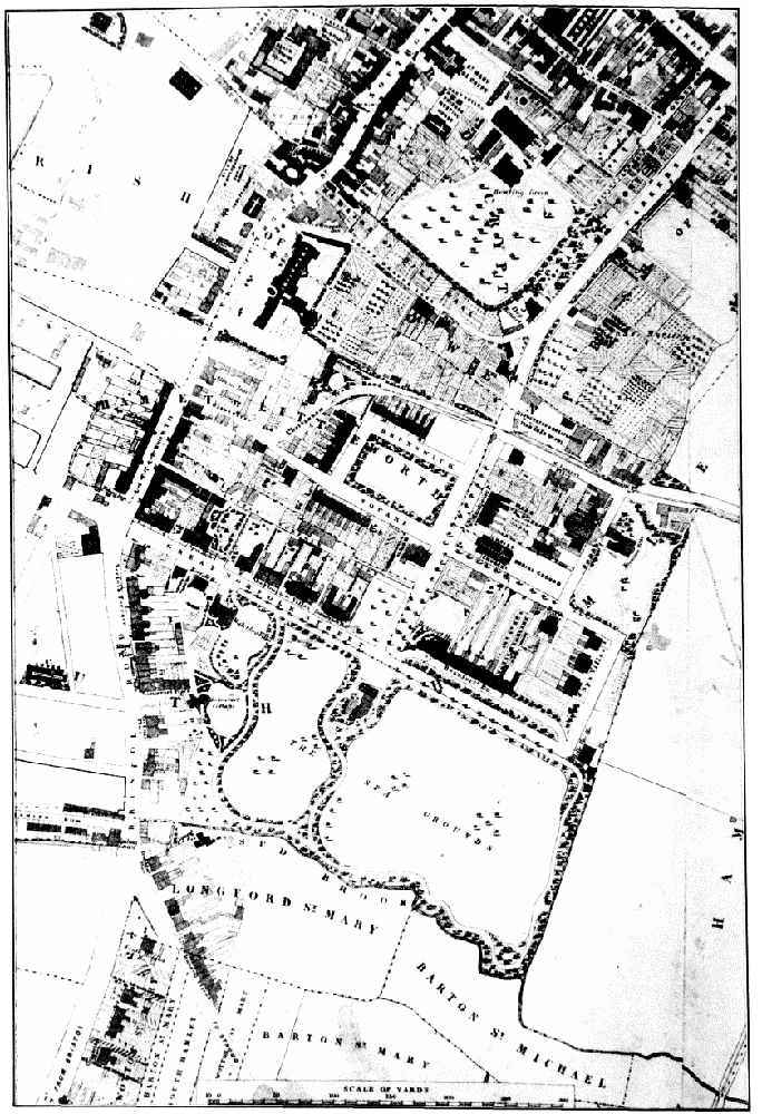
The Spa and the south side of the city, 1843 (north at the top)
Building around the new spa, in the area that was later known simply as the Spa, was encouraged by its position in the extraparochial and low-rated South Hamlet. (fn. 56) South Hamlet contained only seven inhabited houses in 1811; by 1821 the number had increased to 80, and by 1831 to 160. (fn. 57) Building began after 1816 when the company which took over the spa on the bankruptcy of its original promoter James Jelf (fn. 58) began selling off plots of land in a block lying north of the new pump room and walks. Prominent among the developers were the builder William Hicks, the attorney John Chadborn, and the barrister and later M.P. John Phillpotts. (fn. 59)
A new road laid out along the north side of the walks, was originally called Norfolk Street (later Spa Road) and access from it towards the city was opened by a street called Gloucester Place (later regarded as part of Brunswick Road). (fn. 60) On the north side of Norfolk Street, facing the walks, a row of substantial stuccoed villas in classical style with ornamental ironwork was built. The Spa hotel (later Ribston Hall), at the west end, was built by the spa company in 1818 as a boarding house for visitors to the spa. (fn. 61) The house adjoining (later Maitland House) was designed by Thomas Rickman for Alexander Maitland, a former London merchant. (fn. 62) Further east were two pairs of large semi-detached houses called Sherborne Villas, one pair built by John Chadborn. (fn. 63) On the other side of the entrance to Gloucester Place a long terrace called Beaufort Buildings was built in 1818, (fn. 64) and c. 1820 three pairs of small villas, called Spa Villas, and Bellevue House, the latter for Thomas Skipp, a Ledbury timber merchant, were built at the western edge of the spa company's land. (fn. 65) Further north a new church, Christ Church, was opened in 1823, fronting on Gloucester Place, (fn. 66) and north of it a terrace with ornamental plasterwork, called Montpellier Place, was built by James Pollard. (fn. 67) Further west a substantial house called Rignum Villa (later Rikenel) was built, apparently for the merchant William Price (d. 1838). (fn. 68) Waterloo House, west of the spa walks, was one of the many houses at the Spa for which William Hicks was the builder. (fn. 69)
The spa also stimulated building on land adjoining the plots sold off by the company. On the close called Gaudy Green a square (later named Brunswick Square) was developed from 1822 by Thomas Reece, an ironmonger; 19 houses in terraces had been built around it by 1825 when the owners agreed to preserve the central area as a garden. (fn. 70) Near the north-east corner of the spa company's development a short terrace called Rignum Place was begun beside the tramroad in 1821, (fn. 71) and the following year the city corporation built a new road (later called Park Road) alongside the tramroad to connect the Spa to Barton Street. (fn. 72) On the Bristol road below the entrance to Norfolk Street, Norfolk Terrace was completed in the mid 1820s (fn. 73) and building continued down that side of the Bristol road into the entrance of the new Stroud turnpike road, which had been laid out in 1818. (fn. 74) South of the entrance to the Stroud road several houses of a more modest type were built in 1821 on Drakes Croft, a piece of the corporation's hospital land. (fn. 75) The future of the Bristol road as a fashionable residential area was compromised, however, by the rapid development of the docks after the completion of the canal in 1827. Already by 1831 a collection of 'wretched dwellings' of the poor had been established at High Orchard between the canal and the road; they were later removed for the Baker's Quay development. (fn. 76) The old Littleworth suburb, north of the entrance to Norfolk Street, remained an area of poorer housing and premises for trade; the rebuilding of the Squirrel inn, opposite the docks entrance, as the classical-style Albion hotel to designs of Thomas Fulljames in 1831 (fn. 77) was one of the few improvements made there at the period.
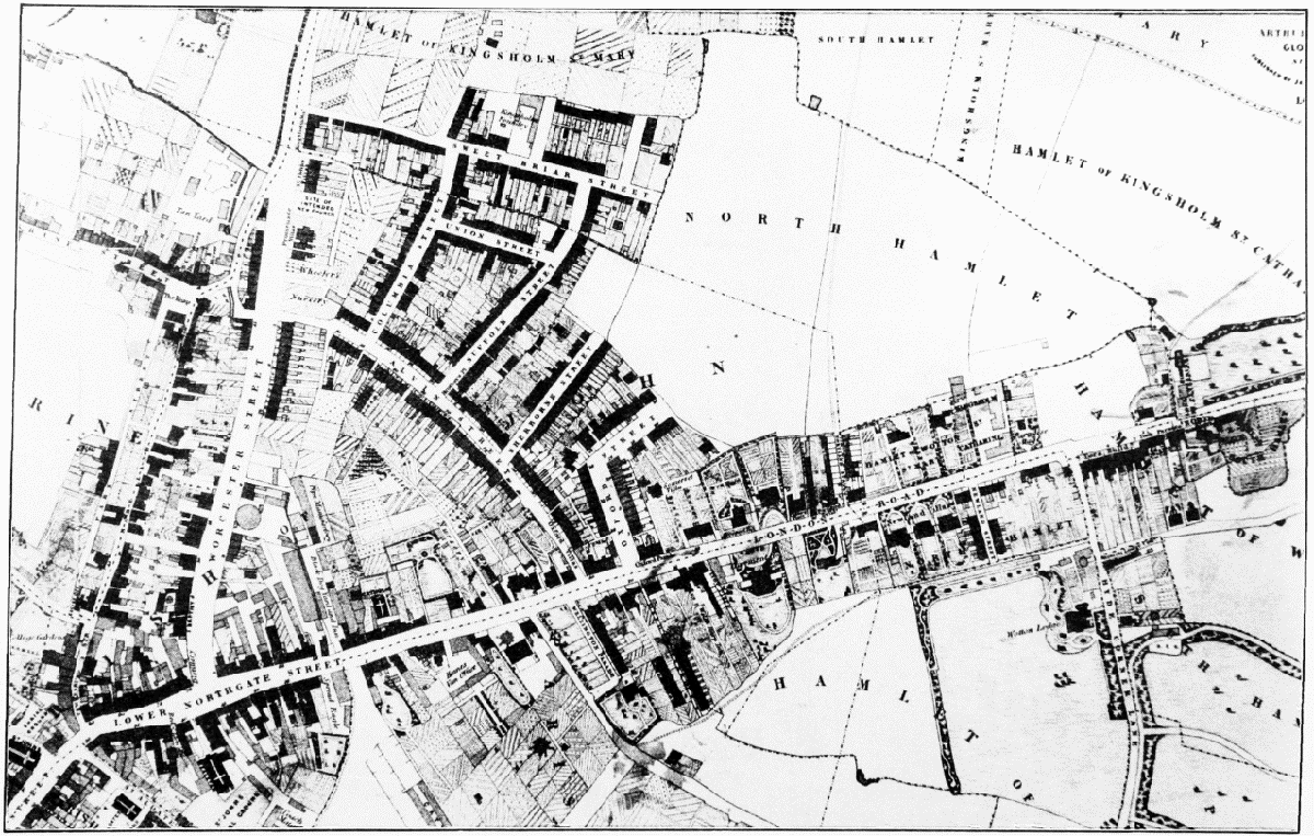
The London Road and Worcester Street area, 1843 (east at the top of the page)
The other area substantially affected by new building in the early 19th century was on the north and north-east fringes of the city. New developments there were chiefly responsible for an increase in the total number of inhabited houses within the city boundary from 1,509 in 1811 to 1,732 in 1821 and to 2,069 in 1831. (fn. 78)
In the inner part of the London road (fn. 79) building had begun by 1814 when Wellington Parade, a terrace built endways to the road, had been completed. (fn. 80) At the same period (fn. 81) some substantial detached stuccoed villas, including Claremont House and the three Newland Villas, were built further out. Coburg Place, (fn. 82) a pair of brick houses on the north side of the road, was described as new built in 1820 (fn. 83) and several of the other houses near it had been built by 1821. (fn. 84) Wotton Lodge, some way south of the road, was built in the mid 1820s by John Michael Saunders, a former soapboiler. (fn. 85) Further out near Wotton, where the road was improved by a diversion in 1821, (fn. 86) land belonging to the two ancient hospitals was built on. The houses called Wotton Parade, east of St. Mary Magdalen's Hospital, were built on land leased in 1820 to John Phillpotts and the building partnership of Henry Edwards and Charles Copner. (fn. 87) In 1827 Joseph Roberts, a printer and lessee of land adjoining St. Margaret's Hospital, planned a terrace of 17 houses, each valued at £500, east of the hospital, and a terrace of 8 houses, each valued at £400, west of it. Roberts was not able to dispose of all the lots and only parts of the two terraces, called Hillfield Parade and York Buildings respectively, were completed. (fn. 88) On the opposite side of the road a large villa called Hillfield House, set in fairly extensive grounds, was built c. 1820 for the banker Thomas Turner. (fn. 89)
New building was most concentrated on the north side of the city and was prompted in part by the building of Worcester Street in 1822 as a new entrance for the Tewkesbury road, replacing the narrow Hare Lane route. The new road was promoted by John Phillpotts and carried out under the powers of the Tewkesbury road turnpike trustees. (fn. 90) Within a few years (fn. 91) it was built up for most of its length with plain brick and stucco terraces. Their commonest elaboration, as with other houses built in the city at the time, was prominent ashlar voussoirs, and some of the terraces had segmental-headed blind arcading framing the window bays. At the same period the attorney George Worrall Counsel (fn. 92) began laying out an estate of several hundred artisans' houses on his land called Monkleighton grounds, lying between Worcester Street and the London road and bounded on the south-west by Alvin Street (formerly Fete Lane). (fn. 93) The building up of Alvin Street, Sherborne Street, and Oxford Street was under way between 1823 and 1825, when the building slump temporarily halted the development and left many of the contractors in financial difficulties. Building had begun again by 1829 when Sweetbriar Street, just beyond the city boundary, was under way; Columbia Street was begun in 1831 and Union Street in 1833. Most of the area was developed in plots for one or two houses by a variety of small contractors, including plasterers, carpenters, and blacksmiths. Some streets were built up with houses with different plans and roof levels, as with one of the main surviving parts in 1984, on the south-west side of Alvin Street. Oxford Street, however, on a single large plot sold to the attorney John Bowyer in 1823, was built up with uniform stuccoed terraces. (fn. 94)
Further out on the Tewkesbury road there was scattered building around the old hamlet of Kingsholm at the same period. (fn. 95) A detached villa called Bijou had been built on the east of the road beyond the junction with Gallows Lane (later Denmark Road) by 1820 (fn. 96) and several pairs of tall brick houses were put up nearby. The site of the old White Barn at the junction with Gallows Lane was offered in building lots by the corporation in 1823. (fn. 97)
There was also some new building in Barton Street on the east side of the city; 107 new houses were added between 1821 and 1831 in the hamlets of Barton St. Mary and Barton St. Michael beyond the city boundary. (fn. 98) At the point where the tramroad crossed the street (at the junction with Park Road, two rows of houses called Foley Place and Foley Cottages were built on land leased by the corporation in 1821. (fn. 99) More houses were added near the junction in the late 1820s and early 1830s, some on the site of the farm buildings of the old Abbot's Barton court house. (fn. 100) Further out, several new houses, probably including the pair of ornamental cottages called Gothic Cottages on the north side of the road, were built before 1822 near the place of entertainment called Blenheim Gardens. (fn. 101) There was also building in the early 1820s at the road junction by the India House inn, (fn. 102) and on the Tredworth road some way south of the junction Thomas Smith, a timber merchant, and others began the development of Barton Terrace (later called High Street). (fn. 103) At the close of the period, however, there were still only widely scattered buildings in outer Barton Street: Gothic Cottages were judged suitable for use as an isolation hospital in the cholera epidemic of 1832, and to go beyond the junction with Park Road was then regarded as 'going into the country'. (fn. 104)
Within the old city refronting in brick and some infilling proceeded in the 1820s, particularly in the western areas. Lower Westgate Street between Archdeacon Street and the Foreign bridge was largely refronted or rebuilt at the period. (fn. 105) North of the Foreign bridge the area between White Swan Lane and Dockham ditch was filled with new houses in 1823, (fn. 106) while south of the bridge the corporation culverted Dockham ditch and made a new road through to the head of the quay in 1825. (fn. 107) In the Island there was some infilling with new houses by William Hicks, William Price, and others. (fn. 108) The western parts of the city were, however, becoming one of the poorest and most insanitary areas, as old houses were subdivided and cottages built on their back courts. (fn. 109) Three houses in Archdeacon Street were occupied as eight tenements in 1815, (fn. 110) and a long plot in the Island, formerly occupied by a single house and industrial premises, was subdivided after 1826 into 19 tenements. (fn. 111)
The last major development of the period within the city came in the years 1832–3 when the builder William Rees laid out, and began to build on, Clarence Street. It linked the city end of Barton Street to Mill Lane (formerly Brook Street), (fn. 112) where part of the Twyver was culverted, (fn. 113) and to the new cattle market opened in 1823.82