A History of the County of Gloucester: Volume 4, the City of Gloucester. Originally published by Victoria County History, London, 1988.
This free content was digitised by double rekeying. All rights reserved.
'Barnwood', in A History of the County of Gloucester: Volume 4, the City of Gloucester, (London, 1988) pp. 410-420. British History Online https://www.british-history.ac.uk/vch/glos/vol4/pp410-420 [accessed 19 April 2024]
In this section
BARNWOOD
The ancient parish of Barnwood lay ESE. of Gloucester and its church stands 2.75 km. from the city's central crossroads. (fn. 1) The proximity of the city and the course of the Roman Ermin Street, the road from Gloucester to Cirencester, through the middle of the parish influenced Barnwood's early development. In the later 19th century two mental hospitals opened there. Barnwood remained predominantly rural in character until the 20th century when it was absorbed by Gloucester.
The ancient parish, which was not clearly defined until parliamentary inclosure in 1799, contained 1,439 a. and was irregularly shaped. (fn. 2) It had many detached parts, most resulting from holdings in open fields and common meadows shared with other parishes, hamlets, and extraparochial places outside Gloucester. The complexity was increased by the existence within the main part of Barnwood of a few detached pieces belonging to the hamlet and vill of Wotton. The boundary of the main part of Barnwood was marked by the Horsbere brook in the north-east, the river Twyver in the south-east, and, for a short distance, the Sud brook in the south-west beyond Coney Hill towards Saintbridge. The northern boundary followed parts of the Gloucester—Cheltenham road and the later Elmbridge Road. The detached parts included several pieces within Wotton to the west, one west of Saintbridge, and one at Longlevens to the north. In the south-east small pieces of Barnwood lying intermingled with Upton St. Leonards and detached parts of neighbouring hamlets represented old closes and holdings in shared open fields that were inclosed in 1897. (fn. 3) Barnwood also had pieces in meadows bordering the Severn north and south-west of Gloucester, including Maisemore Meadow, on Alney Island, which had been inclosed in 1794. (fn. 4)
Parts of Barnwood were taken into Gloucester in 1874 when the city's eastern boundary was extended to the Wotton brook and a railway line (then disused) bypassing Gloucester. (fn. 5) The irregularities in the parish boundary were adjusted in 1882 and 1885 when the detached parts were transferred to other parishes, the northern boundary was made to follow the Gloucester—Cheltenham road, and an extension of the parish south-westwards brought Coney Hill completely within Barnwood, giving it an area of 1,411 a. east of Gloucester. (fn. 6) In 1900 70 a. at Coney Hill were added to Gloucester, and in 1935 Barnwood lost 419 a. to the city and 92 a. in the north to the new civil parish of Longlevens and gained 2 a. from Wotton St. Mary (Without). In 1951 a further 52 a. were transferred to Gloucester, which in 1967 absorbed the remaining 780 a. (315.6 ha.) save for small areas in the east and south-east added to Hucclecote and Upton St. Leonards. (fn. 7) The following account of Barnwood, which relates to the ancient parish except for those detached parts on Alney Island and to the south-east transferred to Maisemore and Upton respectively in 1882, does not cover those aspects of its history from the mid 19th century connected with its transformation to a suburb of Gloucester.
The land of Barnwood is generally flat, rising at its highest only to 54 m. in the south-east and including, in the south-west, part of a low rise at Coney Hill, formerly known as Blake Hill. (fn. 8) Barnwood is on the Lower Lias, on which are large sand and gravel patches. (fn. 9) The parish name indicates that it was once thickly wooded (fn. 10) but by the mid 17th century the soil was cultivated as open-field land or grassland. Inclosure of most of the common land was completed in 1799. Market gardening became important in the 19th century. The land is drained by small streams, including the river Twyver in the south and the Wotton brook, which crosses the middle of the parish.
Ermin Street has remained an important thoroughfare and by the mid 13th century Barnwood shared responsibility for maintaining a bridge carrying the road over the brook at Wotton. (fn. 11) The road, which linked Gloucester with London and Oxford, (fn. 12) was a turnpike through the parish between 1698 and 1718 and between 1723 and 1871 (fn. 13). Upton Lane running south from it near the eastern side of the parish is presumably an ancient route. Church Road further west was a track leading to open fields before 1799 (fn. 14) when it was confirmed as part of a road to Matson, turning westwards at Coney Hill. (fn. 15) The Gloucester—Cheltenham road was a turnpike from 1756 until 1871. (fn. 16)
Barnwood church, which had been built by the 12th century, and the site of Barnwood manor are close together 300 m. south of Ermin Street. In the later 16th century there was a church house north of the churchyard. (fn. 17) Barnwood village developed as a roadside settlement, which with Wotton was strung out along Ermin Street by the early 17th century. (fn. 18) In the late 18th century the main part of Barnwood had c. 35 houses on the road, many set in small orchards and several with farm buildings. (fn. 19) Most of those houses were replaced in the later development of the village, which from 1860 was dominated by a private mental hospital. (fn. 20) New buildings in brick included many villas, a vicarage house and school of the mid 1870, (fn. 21) and a parish room opened in 1898 in memory of G. F. Riddiford, a former resident who had been active in county government. (fn. 22) The older surviving buildings include the 18th-century brick Manor House, which once belonged to the Bubb family's estate. (fn. 23)
Apart from mills on the Twyver there was no ancient outlying settlement in Barnwood. In the north two post-inclosure farmsteads, on Elmbridge Road and by the Horsbere brook respectively, (fn. 24) were removed to make way for housing in the 20th century and Hillview Farm, a cottage built by 1901, (fn. 25) was demolished in 1964. (fn. 26) Lobley's Farm in the south-east is a brick building recorded from 1841. (fn. 27) In the early 1880s the county built an asylum in the south of Barnwood near Coney Hill. (fn. 28)
Nine people in Barnwood were assessed for the subsidy in 1327. (fn. 29) There were c. 117 communicants in the parish in 1551 (fn. 30) and 133 in 1603; (fn. 31) 25 householders were recorded in 1563. (fn. 32) The estimated population c. 1710 was 180 (fn. 33) and by 1801 it had risen to 309. Between 1811 and 1831 the population rose from 306 to 419. By 1851 it had fallen to 358 but by 1861, following residential development and the opening of the private mental hospital, it had risen to 507. (fn. 34)
Barnwood had at least one alehouse in the mid 1660s. (fn. 35) The Salutation, which was assessed on 11 hearths in 1672, (fn. 36) stood north of Ermin Street by a footpath to Churchdown. (fn. 37) It closed after 1817. (fn. 38) Another alehouse, formerly the glebe house, had closed by 1807. (fn. 39) The village blacksmith ran a beer shop in the 1850s. (fn. 40)
Barnwood was the birthplace of the judge Sir Edmund Saunders (d. 1683) (fn. 41) and of the physicist Sir Charles Wheatstone (1802–75). (fn. 42)
MANOR AND OTHER ESTATES.
BARNWOOD, which in 1066 was a member of Gloucester Abbey's Barton manor, (fn. 43) became a separate manor. (fn. 44) The abbey, which was granted free warren on the demesne in 1354 (fn. 45) and administered its Cranham land with Barnwood, retained the manor until the Dissolution. (fn. 46) In 1541 it was given to the dean and chapter of Gloucester cathedral (fn. 47) and by c. 1547, when a lease was granted to Sir Thomas Seymour, was held with Cranham and Wotton manors. The lease passed before 1550 to Thomas Winston, who was followed as lessee in 1560 or 1561 by Edward and Richard Stephens. Edward (d. 1587) devised his lease to his son Thomas, (fn. 48) later of Over Lypiatt in Stroud, who was succeeded, presumably at his death in 1613, by his son Edward Stephens of Little Sodbury. The estate, later farmed from the dean and chapter on leases for 21 years renewed every few years, (fn. 49) belonged in 1661 to Edward's son, Sir Thomas Stephens, and in 1674 to George Johnson of Bowden Park near Chippenham (Wilts.). Under George's will dated 1680 it passed in turn to his wife Mary and his second son William on reaching the age of 24. Mary, William, and Mary Wright, whom William made his trustee in 1707, later defended a Chancery action concerning legacies left by George to other sons, and in 1714 William conveyed the estate to his son William. (fn. 50) The younger William, who became a Bristol merchant, died in 1750 and the estate passed to his wife Elizabeth. Her father Anthony Edwards of Little Shurdington was the leaseholder until his death in 1760. Elizabeth (d. 1773) (fn. 51) was succeeded by her daughters Elizabeth, wife of John Jones, Hester, wife of the Revd. William Walbank, and Sarah, widow of Henry Wyatt (fn. 52) and from 1782 wife of Thomas Wathen. (fn. 53) The dean and chapter, who curtailed the lords farmers' rights over the demesne in the mid 1770s, (fn. 54) took the manorial rights in hand in 1783. (fn. 55) In 1855 the manor passed to the Ecclesiastical Commissioners, (fn. 56) and in 1857 it covered 506 a. in Barnwood, mostly belonging to leaseholders. The commissioners, who in 1867 endowed the bishopric of Gloucester and Bristol with 276 a. in Barnwood, sold off parts of the estate, mostly to the leaseholders. (fn. 57) In 1932 the remaining 303 a. were bought by Gloucester corporation for housing and a cemetery. (fn. 58)
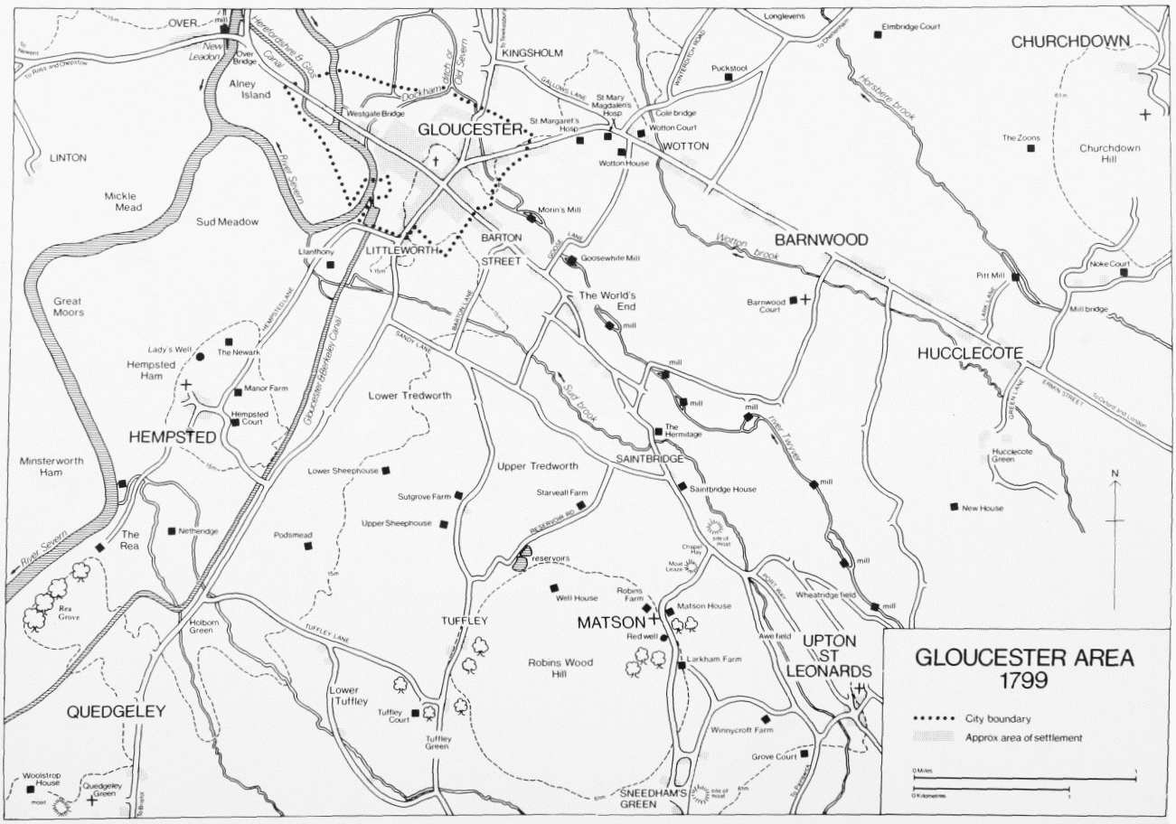
GLOUCESTER AREA 1799
In 1501 Gloucester Abbey granted a lease of the manorial demesne, including the site of the manor west of the church, known later as Barnwood Court, to Lady (Margaret) Bridges; the rent included 40 measures of wheat a year to the warden of Buckholt wood, centred on Cranham. (fn. 59) Humphrey Parker, lessee from 1517, and his sons William and John became wardens in 1519. John was granted a lease of the demesne in 1538, (fn. 60) and in 1543 the dean and chapter granted him and his wife Isabel one for 90 years. At Isabel's death in 1559 or 1560 Barnwood Court passed to her son John Parker, whose wife Margery had a lease in reversion from her brother Thomas Stephens, the lord farmer, in 1587. John by will dated 1602 devised his estate to his son Richard and a life interest in a moiety to Margery. (fn. 61) Richard's widow Mary married George Worrall, (fn. 62) who c. 1631 sold Barnwood Court and the lease in reversion to William Capel. (fn. 63) In 1659 Capel settled the estate on the marriage of his son William. (fn. 64) From 1778 the lords farmer of the manor held a lease of Barnwood Court and part of the demesne. The lessee from 1784 was John Morris (fn. 65) (d. 1788), (fn. 66) who was succeeded by his son Robert. The latter, who conveyed c. 64 a. in Wotton to his brother William, enlarged the estate considerably and in 1799 it covered over 720 a. in Barnwood. (fn. 67) Robert, M.P. for Gloucester, died in 1816 leaving the estate to his son Robert and a life interest in the house to his widow Mary (fn. 68) (d. 1828). (fn. 69) The son, like the father, was a partner in a Gloucester bank, which failed in 1825. (fn. 70) He was declared bankrupt and in 1829 Barnwood Court and 200 a. were bought by Samuel Charles Turner (d. 1833). In 1838 Turner's widow Susannah sold most of the estate, but not the house, to Robert Witcomb, (fn. 71) who owned 192 a. in 1841. (fn. 72) Witcomb died in 1846, and in 1867 his son Robert surrendered the estate to the Ecclesiastical Commissioners. (fn. 73)
Barnwood Court, which contained eight bays in 1650, (fn. 74) dates from the 17th century and probably had an L-shaped plan. It was the residence of the Johnson family from the late 17th century (fn. 75) and of Thomas Cother in the 1770s. (fn. 76) The house, from which a straight avenue led to Ermin Street, (fn. 77) was greatly improved c. 1800 by Robert Morris, (fn. 78) who squared off the plan and added a south front of five bays. In 1841 the house and a few acres belonged to the Revd. William Spencer Phillips (fn. 79) and thereafter had a succession of owners, including James Henry Dowling who bought the freehold in 1871. (fn. 80) In 1937 the house was bought for the vicarage, (fn. 81) which it remained until the mid 1970s. It had been sold by the early 1980s when it was converted as flats.
In 1692 a small estate, held under William Johnson and centred on a farmhouse at the west end of Barnwood village, was bought from Giles Roberts, a clothier, by Nicholas Webb. (fn. 82) Nicholas (d. 1712) was succeeded by his son Nicholas (d. 1714 or 1715), who left the estate in turn to his wife Joyce and his nephew Nicholas Hyett. (fn. 83) Hyett (d. 1777) was succeeded by his son Benjamin, (fn. 84) who sold the estate to Robert Morris c. 1797. (fn. 85) In 1799, after inclosure, Morris sold the estate of c. 70 a. to Thomas Herbert (d. 1810), whose son Edward sold it in 1821 to Jane Trimnell (d. 1856). In 1858 her administrators surrendered the estate to the Ecclesiastical Commissioners (fn. 86) and in 1932 the land was part of that bought by the corporation. (fn. 87) The farmstead was burnt down in 1855 (fn. 88) and the house replaced in 1861 by a pair of cottages later called Bridge Farm. (fn. 89) It was demolished in the 1950s. (fn. 90)
In the early 19th century the Walters family built up a large estate centred on BARNWOOD HOUSE. David Walters bought the house and 32 a., formerly copyhold land owned by Sir Charles Hotham, Bt. (d. 1811), in 1813. (fn. 91) He added to the estate, (fn. 92) which passed at his death in 1833 to his son James Woodbridge Walters. (fn. 93) James owned 719 a. in Barnwood, (fn. 94) was high sheriff of Gloucestershire in 1841, (fn. 95) and died in 1852 heavily in debt to the County of Gloucester Bank, which took over the estate the following year and sold off the land in the late 1850s and 1860s. Large parts were acquired by Arthur Stewart and J. H. Dowling. (fn. 96) The subscribers to the Gloucester asylum bought the house, landscaped gardens, and 48 a. in 1858 and converted the house as a private asylum, later known as Barnwood House Hospital. The hospital's trustees, who in the mid 1870s bought 166 a. in Barnwood, (fn. 97) had by 1935 acquired over 300 a. there. From 1967 land was sold for development (fn. 98) and in 1982 the trustees retained c. 80 ha. (c. 200 a.), some of it let for commercial purposes. (fn. 99) Barnwood House dated from the early 19th century. (fn. 100)
The County of Gloucester Bank sold Barnwood Mill and 119 a. in 1866 to the trustees of the marriage settlement of Walter and Mary Wilkins. In 1878 the county magistrates bought that land for the site of a new county asylum. (fn. 101) The estate was enlarged and from 1908 covered over 310 a. in Barnwood and adjoining parishes. (fn. 102) Much of the land was sold after the early 1960s for housing. (fn. 103) The asylum, known as Coney Hill Hospital, remained in use in 1986.
Gloucester Abbey was taking the Barnwood tithes before c. 1171 when they were confirmed to it. (fn. 104) In 1517 the tithes were leased with the manorial demesne but by 1519 the abbey had reserved the small tithes, evidently all tithes other than those of corn and hay. Of the corn and hay tithes of Barnwood and Wotton manors those of the demesne were known by 1527 as the little tithing and the rest as the great tithing. The abbey had reserved part of the corn and hay tithes by 1538. (fn. 105) The tithes and possibly some land (fn. 106) were granted with the manor in 1541 to the dean and chapter of Gloucester (fn. 107) and the corn and hay tithes were leased with the demesne in 1543. (fn. 108) In the early 1630s the leasehold of those tithes was separated from that of the demesne, and James Mitchell (fn. 109) by will dated 1698 left it to three grandchildren. (fn. 110) The following year the dean and chapter leased part of the corn and hay tithes to James's son-in-law James Small and part to Christopher Capel. (fn. 111) Another part was leased to James Elly (fl. 1721). From 1721 Capel's tithe portion was leased with the small tithes to the curate (fn. 112) and in 1767 the living was endowed with both. (fn. 113) The remaining corn and hay tithes were held under leases renewed every few years and Robert Morris, who acquired a lease in 1797, (fn. 114) took them from 968 a. in 1801. (fn. 115) In 1841 the tithes held under the dean and chapter mainly by the landowners were commuted for a corn rent charge of £350. (fn. 116)
ECONOMIC HISTORY.
The manorial demesne at Barnwood was worked by four ploughteams in 1291. (fn. 117) In the early 16th century much of it was farmed with the site of the manor (fn. 118) and the remainder by tenants on leases for lives or years. (fn. 119) In 1650 the demesne of the Barnwood estate in Barnwood and Wotton comprised 731 a. in common fields and meadows and pasture closes. It was evidently grouped as farms of 200 a. held with Barnwood Court, 152 a., 119 a., 104 a., 81 a., 58 a., and 18 a., (fn. 120) probably held by tenants on leases or at will. By the late 17th century the lords farmer of Barnwood and Wotton manors granted leases of demesne land for terms of 20 years and 11 months, (fn. 121) and in 1750, when Elizabeth Johnson had 431 a., mostly meadow and pasture, in hand, 22 tenants on leases held 410 a., predominantly arable. Of their holdings the largest was 80 a. and half were less than 8 a. each. (fn. 122) In the years 1776–8 the leaseholders surrendered their leases and with the agreement of the lords farmer became tenants of the dean and chapter on leases for terms of 21 years renewed every few years. (fn. 123)
The tenants and services recorded on the Barnwood estate in the 1260s are mentioned under Cranham, where the estate included heavily wooded land; (fn. 124) the customary tenements and those of the mondaymen were evidently in Barnwood as were eight of the holdings owing cash rents and bedrips, including a ½ yardland, 2 mills, and a smithy. (fn. 125) In 1650 the tenants on the Barnwood part of the estate included 4 freeholders and 18 copyholders. The latter held 20 tenements, ranging from 2½ a. to 57½ a. and made up mainly of open-field land with small pasture closes and common meadow land. The copyholders also had common pasture rights and the surviving customs included pannage in Buckholt wood in Cranham. (fn. 126) In 1750 there were 39 copyhold tenements, ranging from less than ¼ a. to 105 a., on the estate in Barnwood and Wotton. They covered 938 a., of which Elizabeth Johnson had 422 a., representing 10 tenements, in hand. (fn. 127) By 1799 Robert Morris, owner of the Barnwood Court and another leasehold estate, had acquired 16 copyhold estates. (fn. 128) Of the copyhold land some was enfranchised c. 1800 (fn. 129) and only 27 a. remained unenfranchised in Barnwood in 1857. (fn. 130)
Barnwood's open fields were small and in the late 18th century included in the north Badnum field, Sand field in which Wotton hamlet had a small share, and Wellfurlong, and in the south Ash field, Church field, and Redding field. Lilly field, east of Upton Lane, probably originated as part of a field in which neighbouring Hucclecote had shared. Barnwood also shared larger fields with neighbouring hamlets and Upton St. Leonards, including Colebridge field, Elbridge field, and Chamwell field to the north-west, Windmill field and Upper Tredworth field to the west, and Bottom field and Nuthill field to the south-east. (fn. 131) There had been some consolidation of the Barnwood demesne in the shared fields by the early 16th century (fn. 132) but much of the land lay in small pieces in 1650 when a three-course rotation was apparently followed on the Barnwood estate. (fn. 133)
The main common meadows in which Barnwood shared were Walham and Sud Meadow, beside the Severn north and south-west of Gloucester respectively. (fn. 134) In 1650 the Barnwood estate also had small pieces at Wickham in Maisemore Meadow on Alney Island, in Dry Meadow and Frize Meadow between Longford and Twigworth, and in a common meadow in Upton bottom south-east of Barnwood. Three tenants took hay from ½ a. in Wickham every other year and another from ½ a. in Walham and Dry Meadow every alternate two years. (fn. 135) In 1780 a piece in Walham was said to be changeable every other year for ½ a. in Dry Meadow. (fn. 136) Stints of 3 horses and 48 sheep to the yardland in 1559 and 1571 respectively apparently applied to common in the open fields. In 1571 two men were appointed to ensure that pigs, which also fed in the fields, were ringed. (fn. 137) In 1650 the tenants' common rights in the open fields were stinted at 80 sheep and 16 cattle for every yardland held. After the hay harvest they also had common rights in Walham and Dry Meadow, and three tenants could graze cattle in Sud Meadow until All Saints. (fn. 138) Barnwood had a small common at Wotton containing less than ¼ a. It lay east of the brook and had been taken into an adjoining pasture close by 1750. (fn. 139)
In the mid 17th century many of the houses in Barnwood had orchards, and cider was produced. (fn. 140) In the early 18th century the parish was said to be rich in arable and pasture. (fn. 141) Market gardens had probably been established there by 1769, when two small nurseries were recorded on the manorial demesne. (fn. 142) Open-field land probably decreased in the 18th century, at the end of which Barnwood had more pasture than arable. (fn. 143)
The inclosure of the Barnwood fields was completed, with that of most fields and meadows which the parish shared with Wotton and other hamlets, in 1799 under an Act of 1796. The award allotted commonable land and old inclosures in Barnwood to 21 landholders, who with one exception were tenants of the dean and chapter and met their share of the inclosure cost by the sale of part of the land allotted them. Robert Morris, the principal beneficiary received 761 a. and John Jordan 134 a. Three others received between 11 a. and 43 a., nine between 1 a. and 10 a., and seven fractions of 1 a. (fn. 144) The award dealt with pieces of Barnwood in Sud Meadow, which was inclosed in 1815. (fn. 145)
In the early 19th century c. 96 a. of arable in the north were laid down as pasture (fn. 146) and in 1838 Barnwood had 989 a. permanently under grass and 450 a. under crops. (fn. 147) Dairying was carried on, (fn. 148) and in 1866 the parish returned 144 cattle, both beef and dairy, 307 sheep, and 108 pigs. Leys of clover and lucerne were part of the crop rotation which included wheat, barley, beans, potatoes, and other roots. (fn. 149) Market and nursery gardens in the parish, including Longlevens (called Springfield), (fn. 150) catered for Gloucester's growing population, and by 1863 one farm's 86 a. of arable had been adapted for market gardening and its 34 a. of grassland partly planted with fruit trees. (fn. 151) Orchards covered at least 44 a. of the parish in 1896. (fn. 152) Before 1901 the Gloucester firm of J. C. Wheeler and Son laid out extensive nurseries north of Barnwood (fn. 153) and from the late 1920s a firm of rose growers was recorded. (fn. 154) Dairying remained important, and Barnwood, which in 1905 had 765 a. of permanent grassland and 240 a. of arable land, (fn. 155) returned 320 cattle, including 137 milk cows, 167 sheep, and 300 pigs in 1926, as well as a large number of poultry. (fn. 156)
In 1856 five farmers were listed in the parish and in 1863 six. (fn. 157) The number of farms, including smallholdings, was evidently higher, for in 1896 a total of 24 agricultural occupiers was returned. (fn. 158) The number returned in 1926 was 13, of whom 8 had less than 50 a., two more than 150 a., and another more than 300 a. (fn. 159) In 1881 the farmland of Barnwood House Hospital was taken in hand and placed under the management of a bailiff. (fn. 160) The county asylum's estate was also farmed directly in the early 20th century, and in 1932 a dairy herd was established. The farm supplied both county mental hospitals and after the introduction of the National Health Service produce was also sold to other hospitals. In the late 1950s and early 1960s direct management was gradually abandoned and the land granted to tenants, including the county council which took c. 60 a. in the south-east for smallholdings. (fn. 161) Barnwood House Hospital, which began releasing land for building in 1967, ended direct farming in 1971 and sold grazing rights over agricultural land. (fn. 162) From the late 1960 s much land in Barnwood was taken for houses and factories and most of that remaining in agricultural use in the early 1980s provided grazing.
Three corn mills were recorded in Barnwood on the river Twyver. The highest, in the south-east corner, (fn. 163) was probably that held by Robert the sheriff in 1221 (fn. 164) and called Sheriff's Mill in the 1260s. (fn. 165) It was later held by copy (fn. 166) and in 1775 was granted to James Wintle, a Gloucester pinmaker, who sold it to William Green in 1793. (fn. 167) The mill was later part of J. W. Walters's estate (fn. 168) and was sold with some land in 1862 to Arthur Stewart (d. 1879), who also acquired the nearby Saintbridge House estate. In 1887 the county magistrates bought the mill and 85 a. for their asylum estate. (fn. 169) The mill had ceased working by 1921 (fn. 170) and the building, incorporating an 18th-century house and a 19th-century brick mill, was used as a farmhouse in 1983.
Barnwood Mill, downstream, (fn. 171) was that held in the 1260s by Joan of Clayford. (fn. 172) It was later held by copy (fn. 173) and was bought in 1783 by John Morris. (fn. 174) It later belonged to J. W. Walters. (fn. 175) The county magistrates, who acquired the mill with an estate for their new asylum in 1878, (fn. 176) converted the buildings, including a farmhouse, as patients' cottages (fn. 177) and the mill ceased working. (fn. 178) The buildings were demolished after 1950.
The lowest mill of the three, standing south-east of Coney Hill, (fn. 179) was leased with the demesne from 1501 when it was a customary messuage called Holder's Mill. (fn. 180) In 1750 it was held under lease with 26 a. by Thomas Blizard. (fn. 181) From 1838 the mill was in Robert Witcomb's estate (fn. 182) and by 1851 its house was a farmhouse. (fn. 183) It was known as Court Farm in 1882 when the mill was no longer working, (fn. 184) and was demolished after 1937. (fn. 185)
The great majority of people listed in Barnwood and Wotton in 1608 were engaged in agriculture, including 35 husbandmen or husbandmen servants, and trades were represented by 4 millers, 2 tailors, a wheeler, and a carpenter. (fn. 186) Barnwood had a cordwainer in 1669 (fn. 187) and the usual village trades were recorded there in the 18th century. (fn. 188) In 1811 agriculture provided a livelihood for 51 families out of 73 and in 1831 for 41 families out of 83, the change reflecting the gradual transformation of Barnwood from a village to a suburb of Gloucester. (fn. 189)
LOCAL GOVERNMENT.
A court roll of Barnwood manor survives for 1292, when the court was attended by the abbey's Cranham tenants and dealt with estate matters, including the care of woodland. (fn. 190) By 1558 the court was held, sometimes in the church house, (fn. 191) by the lord farmer and was attended by the Wotton and Cranham tenants, who made their presentments separately. In the period 1558–71 the court usually met twice a year and was concerned with tenures, the collection of pig tack or pannage, the maintenance of ditches, driftways, and footbridges, and infringement of common pasture rights. (fn. 192) In the years 1726–47 and 1774–1867, for which there are court books and a record of a 1796 court of survey, the court's business was almost exclusively tenurial. The court met frequently at the Salutation inn and from 1783 was held by the dean and chapter. (fn. 193) In 1821 Dudstone hundred court ordered the dean and chapter to provide stocks and a pound at Barnwood. (fn. 194)
The parish had two churchwardens in 1543 (fn. 195) and two surveyors of the highways in 1665. (fn. 196) The churchwardens received the rent from Barnwood common in the mid 18th century. (fn. 197) The accounts of the two overseers of the poor for the years 1705 and 1709–11 survive. (fn. 198) Annual expenditure on poor relief rose from £110 in 1776 to £292 in 1803. In the early 19th century the number of persons receiving regular help, 30 in 1803, fell and the cost of relief was kept down despite a considerable increase in the number receiving aid occasionally, 16 in 1803 and 105 in 1815. (fn. 199) In the early 1830s the annual cost averaged £139. (fn. 200) The parish, which until 1799 had used the church house as a poorhouse, (fn. 201) built ten small poorhouses with gardens at the east end of the village in the early 19th century. Those houses were sold to J. W. Walters (fn. 202) after the parish joined the Gloucester poor-law union in 1835. (fn. 203) Barnwood was later part of Gloucester rural district until absorbed by the city in 1967. (fn. 204)
CHURCH.
In the mid 12th century Barnwood church was dependent on St. Mary de Lode church, Gloucester, which had been appropriated by Gloucester Abbey. (fn. 205) Barnwood church was described as a chapel in 1315 (fn. 206) and 1498. At the latter date it had a chaplain and a stipendiary priest. (fn. 207) In the early 16th century it was served by curates appointed for life. (fn. 208) Later the dean and chapter of Gloucester, owners of the tithes, appointed curates (fn. 209) and by 1735 the living was called a perpetual curacy. (fn. 210) Following a fuller endowment in the later 18th century (fn. 211) it became known as a vicarage and was first recorded as such in 1799. (fn. 212) It has remained in the gift of the dean and chapter. (fn. 213)
In the early 16th century the curate received offerings and all tithes save those of corn and hay for his salary, which was valued at £5 8s. in 1535, and he paid Gloucester Abbey a pension of 6s. 8d. (fn. 214) From 1538 he received 20s. a year for his tithes from the demesne (fn. 215) and in 1603 his tithes were worth £8. (fn. 216) Payment of tithes in kind had ceased by 1704 when the curate apparently received £10 a year in composition from the impropriators. (fn. 217) From 1721 the curate had a lease of the small tithes and Capel's tithe portion, the corn and hay tithes from 166 a., (fn. 218) and in 1750 the living was worth £35. (fn. 219) Its value increased following an allotment in 1765 of £200 from Queen Anne's Bounty, and in 1767 the impropriators endowed the living with the small tithes and Capel's tithe portion to obtain a further award of £200 in 1769. (fn. 220) The grants were used to buy 17 a. in Minchinhampton. (fn. 221) The vicar's tithes were commuted for a rent charge of £176 in 1841, (fn. 222) and in 1856 the vicarage was worth £195. (fn. 223)
A small glebe house recorded in 1704 stood north of Ermin Street. It was later used as an alehouse and by 1799 had been converted as four tenements, which were demolished c. 1810. (fn. 224) In 1872 an area of 5½ a. south of Ermin Street was acquired for the glebe, (fn. 225) and in 1873 a vicarage house to designs of F. S. Waller & Son was built on it some way from the road. (fn. 226) That house was standing in the mid 1980s. Barnwood Court, next to the church, was the vicarage from 1937 to the mid 1970s, when a bungalow was built in its grounds for the vicar. (fn. 227)
In 1548 Thomas Baskerville, a former monk of Gloucester Abbey, was curate. George Cooper, a former Franciscan and curate of Cowley, was curate the following year (fn. 228) and in 1551 was found unable to repeat the Ten Commandments. (fn. 229) In 1563 the curate, Lewis Evans, who also held the livings of Churchdown and Upton St. Leonards, was unable to serve Barnwood and Upton at appropriate times. (fn. 230) William Perkins, curate by 1572, (fn. 231) was not preaching quarterly sermons in 1576 (fn. 232) and was described as a sufficient scholar but no preacher in 1593. (fn. 233) He retained the living until 1634 or 1635. (fn. 234) There is evidence of puritan feeling in the parish in the later 1630s when the churchwardens were dilatory in moving the altar to the east end of the chancel and one parishioner went to sermons in Gloucester in preference to attending the parish church. (fn. 235) In 1648 the minister of Barnwood, William Edwards, was a signatory of the Gloucestershire Ministers' Testimony. (fn. 236)
Curates in the later 17th century often held livings nearby (fn. 237) and Thomas Merrett, curate by 1690, (fn. 238) was usher of the Crypt grammar school, Gloucester. (fn. 239) In 1705 the parishioners raised a subscription to pay his successor Richard Eaton for a weekly sermon and provide an annuity of £5 for Merrett. (fn. 240) For much of the 18th and 19th centuries the living was served by non-resident incumbents or stipendiary curates, most of whom lived in Gloucester. John Longdon, who became perpetual curate in 1741, (fn. 241) moved to Winstone when he became rector there in 1742. For a time he served Barnwood in person (fn. 242) but from 1787 he employed stipendiary curates, including from 1790 Arthur Benoni Evans, (fn. 243) headmaster of the College school, Gloucester. Evans, who succeeded Longdon as vicar in 1809 and was also rector of Coln Rogers in 1814, employed curates at Barnwood from 1822. The latter included his nephew Thomas Evans, who became his assistant at the school in 1826. A. B. Evans retained the living until his death in 1841. (fn. 244) A later headmaster, Hugh Fowler, became vicar of Barnwood upon his retirement in 1872 and in a few years built a vicarage house, restored the church, and promoted the building of a National school. (fn. 245) The opening of missions in those parts of the parish affected by the suburban growth of Gloucester from the later 19th century is discussed above. (fn. 246)
A small piece of land which had supported an anniversary in the parish was sold in 1553. (fn. 247)
The parish church had been dedicated to ST. LAWRENCE by the mid 12th century, (fn. 248) although a dedication to St. Margaret was recorded in 1287 (fn. 249) and one to St. Michael and All Saints in the early 18th century. (fn. 250) It comprises chancel with north chapel, nave with east bellcot and north aisle and porch, and west tower. Parts of the nave and the chancel arch are of the later 12th century. The north arcade and aisle were added in the early 13th century and some decorative painting of that date survives on the arcade. The bellcot was placed over the chancel arch in the 14th century. In the early 16th century the chapel and tower were built and the nave was reroofed. (fn. 251) The chancel was said to be in decay in 1548 and also in 1563 when the windows were out of repair. (fn. 252) The nave roof was ceiled in 1730, and pews and a communion table, the object of a bequest by Elizabeth Whitehead (née Johnson), were provided in 1756. (fn. 253) By the mid 19th century the ceiling had been removed, a west gallery erected, and the south doorway blocked. The chancel, which probably dated from the 13th century, was heavily restored in the 1850s or early 1860s. The lancet east window was replaced by a three-light window, and a piscina, sedilia, and a credence were renewed. A nave window was altered then. The church was restored in 1873 and 1874 to the designs of F. S. Waller and, in the chancel, Ewan Christian. The south wall of the nave was rebuilt and the doorway opened up, and the north wall of the aisle was partly rebuilt. The north porch was presumably rebuilt at the same time. Several windows were replaced and the aisle was reroofed. The gallery was removed, the church repewed, and other new fittings included a stone pulpit. (fn. 254) A screen was installed in the tower arch after 1914. (fn. 255)
The appearance of the interior of the church was much altered during the incumbency of M. O. Seacome, vicar 1958–84. (fn. 256) Most of the 19th-century innovations were removed and the chancel cleared of monuments. The organ and choir stalls were moved to the nave where new furnishings were introduced, including late 18th-century pews, formerly in St. Mary's church, Woolwich (Kent), and a pulpit of similar date which was restored and painted. The floors of the chancel and chapel were paved with stone and that of the nave retiled. In 1966 a fibreglass sculpture of Christ in Majesty, by Darsie Rawlins, was placed over the chancel arch. (fn. 257)
The octagonal font is richly carved and is contemporary with the early 16th-century additions to the church. (fn. 258) The north chapel contains monuments to members of the Parker and Johnson families and other memorials are in the base of the tower, which was used as a vestry in 1983. The chancel, nave, and aisle contain stained-glass memorial windows of the 19th and 20th centuries. The tower's four bells were recast by Abraham Rudhall in 1698 or 1699 as a peal of six, (fn. 259) of which one was removed shortly afterwards. (fn. 260) In 1873 a treble was given as a memorial to Mary Dowling, (fn. 261) and in 1913 two more were added. (fn. 262) The plate includes a chalice and paten of 1761 and a chalice of 1863. (fn. 263) The registers survive from 1651 and contain entries for Wotton. (fn. 264)
The churchyard has the base of an ancient cross, which in 1911 was in the garden of Barnwood Court, (fn. 265) and two carved tombchests of the 18th century. A lich gate erected south-east of the church in 1921 as a memorial to the dead of the First World War (fn. 266) had been taken down by 1979.
NONCONFORMITY.
In 1676 eight protestant nonconformists were recorded at Barnwood. (fn. 267) Thomas Shipton, one of several people presented between 1679 and 1685 for not attending the parish church, (fn. 268) belonged by 1660 to the Independent church in Gloucester led by James Forbes. (fn. 269) The two Presbyterians recorded at Barnwood in 1735 were presumably members of the Barton Street chapel in Gloucester. (fn. 270) There is no evidence of any nonconformist meeting in Barnwood before the mid 19th century.
EDUCATION.
A charity school for Barnwood and Wotton had been founded in Barnwood apparently with a gift of £100 from Mary Wright, by 1716 when the dean and chapter, in whom the gift was vested, decided to pay £3 a year to it. (fn. 271) From 1754 the lord farmer paid the dean and chapter £5 a year for the school's support. (fn. 272) The Barnwood school teaching 35 children in 1818 presumably derived from the charity school, though subscriptions were the only source of income mentioned. (fn. 273) In 1833 it was supported entirely by D. or J. W. Walters, apart from the dean and chapter's £5 a year, (fn. 274) payment of which was charged on the Barnwood Court estate in 1821 and on Robert Witcomb's estate in 1843. (fn. 275) The school, which was held in a cottage north of Ermin Street, (fn. 276) was also supported by subscriptions and other payments in 1847 when, with one teacher and 50 children, mostly girls, it was insufficient for the population. (fn. 277)
It was replaced by a National school opened in 1874 in a new building, incorporating a school-house, south of Ermin Street on land given by the vicar. The National school had mixed and infants' departments (fn. 278) with an average attendance in 1885 of 76, including children from Wotton. (fn. 279) Beginning in 1893 it was enlarged several times (fn. 280) and in 1904 it had an average attendance of 169. (fn. 281) Attendance had declined to 143 by 1938. (fn. 282) As Barnwood C. of E. Primary school it had 148 pupils in 1984. (fn. 283)
CHARITIES FOR THE POOR.
Barnwood benefited from the charity established under the will of Giles Cox of Abload's Court, Sandhurst, dated 1620. The trust deed of 1633 assigned 40s. a year of the profits of the charity estate to help householders not receiving poor relief, (fn. 284) but the parish apparently received £1 10s. a year in the late 18th century (fn. 285) and persons on poor relief received doles before 1826 when the original amount was being distributed every few years. (fn. 286) The charity, which was regulated by a Scheme of 1892, allotted Barnwood £9 16s. in its distribution for 1897. (fn. 287) The separate Barnwood charity established in 1957 on the division of the Cox charity (fn. 288) had an income in 1971 of £7, which was distributed among the poor whenever necessary. (fn. 289)
Jasper Clutterbuck, a Gloucester alderman, by will dated 1658 gave the poor of Barnwood a portion of the rent from land in the parish which he left to the city corporation. (fn. 290) The charity, if ever applied, probably lapsed on expiry of the lease by which he had held that land. (fn. 291)