A History of the County of Surrey: Volume 3. Originally published by Victoria County History, London, 1911.
This free content was digitised by double rekeying. All rights reserved.
'Parishes: Thursley', in A History of the County of Surrey: Volume 3, (London, 1911) pp. 59-61. British History Online https://www.british-history.ac.uk/vch/surrey/vol3/pp59-61 [accessed 25 April 2024]
In this section
THURSLEY
Thoreseley (xiv cent.).
Thursley was originally a part of the parish of Witley. The length of the old parish was about 6 miles from north to south, about 2 miles wide in the northern part, tapering to the south and inclosing the town of Haslemere in an elbow at the extreme south. The boundary was here altered in 1902, by order of the Local Government Board, 7 March 1902, part of Thursley, covering 392 acres, which had been much built over by the extension of Haslemere, being transferred to Haslemere parish.
The area of the parish is now 3,986 acres, 1,202 of which are heath land, and 29 water. The parish is traversed throughout its length by the London and Portsmouth road, which rises in easy slopes for over 2 miles from Thursley Common to the top of Hindhead, 903 ft., or by another survey 895 ft., above the sea.
The road winds below the top of the hill along the edge of the great hollow called vulgarly the Devil's Punch Bowl. The old name was Haccombe, i.e. Highcombe, Bottom. The old road was higher up the slope near the top; it can still easily be seen. The stone marking the site of the murder of a sailor of name unknown, by three fellow travellers in September 1786, is now by the side of the new road. But the crime was committed upon the old road, which was diverted in 1826. The murder is further commemorated by a tombstone, with a bas-relief of the act, in Thursley Churchyard. The perpetrators were hung in chains on a gibbet by the side of the road, pictures of which exist. The whole district was formerly extremely wild and dangerous. Pepys travelling in Surrey in 1668 engaged a guide to conduct him over the road from Guildford to Petersfield. This was a mere track. A properly metalled road was made first in accordance with an Act of Parliament of 1749 for completing the road from Kingston to Petersfield. The road which branches off from Hindhead to Haslemere and into Sussex, to Midhurst, was made at the same time. The view from Hindhead challenges comparison with any in the south of England. Though not so extensive as that from Leith Hill, which including the Tower is 60 ft. higher, the foreground is more broken and diversified. The whole western half of the South Downs lies in front to the south, the Hampshire chalk hills to the west, the whole country to the Thames Valley is overlooked northwards. The advanced position of the hill, jutting out southward from the Green Sand range of Surrey, yields a view eastward along the middle of the Weald, with the Leith Hill range on one hand, the South Downs on the other, and Crowborough Beacon, in Sussex, appearing in the blue distance beyond. Till some forty years ago the spot was still desolate. The 'Royal Huts,' the old inn, was the only house except two or three cottages which stood near it. Since then, Professor Tyndall having led the way, many houses have been built, but not on the top of the hill, and not generally in Thursley parish. The summit, and all the beautiful open common to the north, has been preserved as open space, by the purchase of this part of the waste of the manor of Witley, from the representatives of the late Mr. Whitaker Wright, by subscribers for the Commons Preservation Society (1905). Thursley is still a purely rural parish; there is a small village near the church, and a small collection of houses at Bowlhead Green, where a Congregational chapel was built in 1865. The picturesqueness of the parish is not exhausted with Hindhead. The view from the churchyard westward is very fine, and the valley of Cosford is very beautiful.
The soil is the Lower Green Sand almost entirely; the parish merely touches the Atherfield and Wealden clays on part of its south-east border. The Hammer Ponds, which formerly worked iron forges and a furnace owned by the Smiths of Rake, Witley, are partly in the parish. On the common, but in Frensham parish, are the curious conical sand-hills called the Devil's Jumps. They are natural, not, as has been supposed, barrows. Neolithic implements have been found, an axe-head by Mr. Iolo Williams, now in the Charterhouse Museum, some arrow-heads and flakes, also in the Charterhouse Museum. The farm near the church seems to belong to the 16th century in the back part and interior. The principal landowners are Mr. R. W. Webb of Milford House, Witley; the Earl of Derby, Captain Rushbrooke of Cosford, Mr. Yalden H. Knowles, and Mrs. Gooch.
There has never been a separate manor of Thursley, but the manor of Witley extends over the parish. In the 16th century tenants of Witley Manor were holding lands at Jordans, Robyns, Bagleys, and elsewhere in the 'hamlet' of Thursley. (fn. 1)
CHURCH
The church of ST. MICHAEL, THURSLEY, was originally a chapel-of-ease to Witley. The mother church is mentioned in Domesday, but this is not, making it a matter of doubt whether there was a chapel on the site prior to about 1100, which is the approximate date of the earliest features in the existing building. There are a number of 18th and 19th-century monuments in the churchyard, among which is the famous 'sailor's tomb,' mentioned above.
The church is constructed of Bargate stone rubble with Bargate stone and chalk dressings in the old parts. The same rubble, with dressings of Bath stone and some red brick, is employed for the new work. Before enlargement there was a nave 38 ft. 3 in. by 21 ft., and a chancel 18 ft. by 16 ft. 9 in., separated by an arch, and with a porch on the south of the nave. Rising out of the centre of the nave, was—and happily still is—a slender timber bell-turret, with graceful shingled spire standing upon four enormous baulks of moulded timber, which rest upon the nave floor, and are tied together with braces. The whole turret closely resembles that of the west end of Alfold Church in this neighbourhood, and the two were doubtless erected, about 1500, by the same hands.
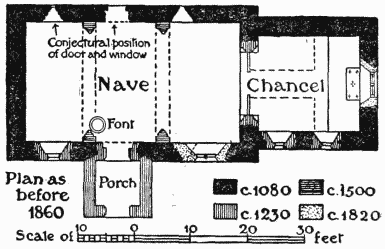
St. Michael, Thursley: Plan as before the Enlargements of 1860, etc.
Until about the year 1860 the proportions of the simple early building of about 1100 remained unaltered, save for the addition of this timber turret and spire (which, however, made no alteration in the area occupied by the nave and chancel); at that time the church received its first enlargement by the addition of a short aisle and a vestry on the north of the nave; new windows were inserted in the west and east walls and on the south of the nave, and the church was reseated, a gallery being retained at the west end. In 1883–4 the nave was lengthened westwards, and a transept, baptistery, and porch added on the south of the nave, the additions involving the removal of the old west wall and part of the south wall. The accompanying plan, drawn with the help of one taken before the 1860 alterations, shows some of the ancient features that still remain, as well as those that have been removed in the successive enlargements.
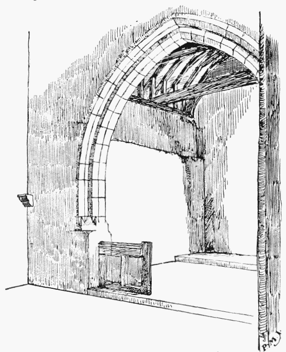
Chancel Arch, Thursley (Furniture Omitted)
The turret and its spire are shingled, and on the south side of the former is a large old sundial, in place of a clock, bearing the inscription, 'Hora pars vitae.' The body of the turret has been heightened 3 ft. Its timbers are remarkably massive as seen from within the nave. Four huge uprights, worked with a series of hollow chamfers, and measuring on the square about 2 ft. 6 in., rise from the nave floor, and great arches of oak spring from them and span the nave. These arches, which are four-centred or elliptical in outline, have a hollow chamfer on the edges, and between them are two other arches of similar shape, but rising from a beam on either side (north and south), carried by a low four-centred arch.
The nave retains only one of its original windows, a small round-headed opening, somewhat widely splayed, in the eastern part of the north wall. It was preserved when the church was enlarged, and now looks into the aisle. Originally there was a similar window to the westward and a small door between in this wall, probably matched by others in the opposite wall; and in the west end the outline of a round-headed opening was noticeable until the last extension. The south wall seems to have been altered about the middle of the 13th century, when a lancet and doorway took the place of the earlier features. Later still, perhaps in the 15th century, a two-light opening was inserted in the eastern part of the south wall, destroying another early window, and this and a similar insertion in the east wall of the chancel seem to have been fitted with wooden frames in place of the stone tracery early in the 19th century.
The chancel arch, built of hard chalk, is of mid-13th-century date. Its piers are square to a height of 4 or 5 ft. from the floor, and then rise in two chamfered orders, with pyramidal stops at the base, the chamfers continuing without any break round the arch. This arrangement suggests that there was originally a low screen standing in the opening. There are at present the lower parts of a 15th-century screen, which has been deprived of its traceried upper half. The arch should be compared with one of similar date and character in West Clandon Church, near Guildford. In the north-east angle of the nave is a moulded bracket of black marble which looks as if it had carried the beam for the rood, independently of the low screen.
The north wall of the chancel is strangely devoid of features, there being no window, door, or aumbry therein. There is a break in the wall horizontally near the top, which is much thinner. In the south wall are two lancets of about 1250, the openings of which appear to have been widened at some time, and the western, which was a low side window and has had its head raised since Cracklow's view of 1823 was taken. In the eastern part of the same wall is a small piscina of 1250.
Both in the nave and chancel the roofs are mostly ancient, the timbers of black oak, very massive and in good preservation; some of the beams are of unusual size for so small a building. There are some slight remains of plain 15th-century seats, worked in with new material, in the chancel.
The font is the original, a large circular tub-shaped block of hard Bargate stone, brownish-orange in colour, and quite plain save for a band of cheveron or arrow-head ornament incised round the rim, and a little lower down a projecting moulding of circular section, which may have served the practical purpose of giving a grip to the chain or rope by which this huge block was hoisted about between the quarry and the church. This font appears to belong to an early group in Surrey and Sussex, in which are comprised Tangmere (with a circular moulding), Alfold, Yapton and Walberton, the last two showing similar incised ornamentation to the rims.
Of the three bells one is mediaeval, with an undecipherable black-letter inscription, the others are modern.
Among the church plate is a cup of 1662 and an old pewter plate.
The registers date from 1613, which leads to the inference that it was a separate parish in fact; it had churchwardens of its own, but up to the middle of the 19th century it was usually held with Witley. (fn. 2)
ADVOWSON
A chapel at Thursley was taxed with Witley in 1291. (fn. 3) It is said to have been erected into a separate parish in 1838, (fn. 4) and the benefice is still in the gift of the vicar of Witley.
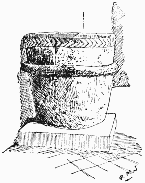
The Font, Thursley
CHARITIES
Henry Smith's Charity applies to Thursley. Moon's Money, a charity of unknown origin, was applied to the maintenance of the workhouse.