Survey of London: Volumes 43 and 44, Poplar, Blackwall and Isle of Dogs. Originally published by London County Council, London, 1994.
This free content was digitised by double rekeying. All rights reserved.
'Between Poplar High Street and East India Dock Road: Newby Place, Mountague Place and Bazely Street (west side)', in Survey of London: Volumes 43 and 44, Poplar, Blackwall and Isle of Dogs, (London, 1994) pp. 180-188. British History Online https://www.british-history.ac.uk/survey-london/vols43-4/pp180-188 [accessed 20 April 2024]
In this section
Newby Place, Mountague Place and Bazely Street (West Side)
Newby Place
Newby Place was laid out in two stages (fig. 64). The section south of Mountague Place was set out following the purchase of that land by William Newby in 1791; the northern part dates from the creation of the churchyard of All Saints' in 1822. (fn. 2) The relatively narrow section leading into the High Street – 17ft 3in. wide at its narrowest point – was widened in 1884. (fn. 3)
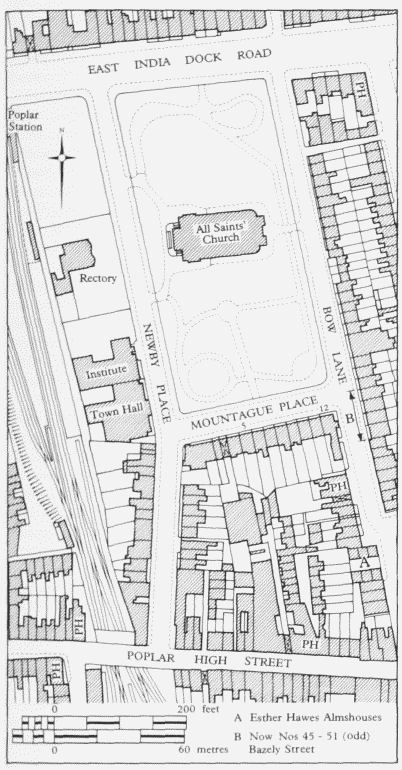
Newby Place, Mountague Place and Bow Lane area. Site plan based on the Ordnance Survey of 1914
William Newby bought a house and three acres of land from the trustees of William Thorns in 1791 for £300. (fn. 4) The ground was described as enclosed arable in 1712, but by 1766 had been converted into gardens. (fn. 5) Newby's title was not entirely sound, for he bought only five of six shares, the other one belonged to Thorns's eldest son, presumed, but not certainly, dead without heirs (see page 177). (fn. 6)
The new street was set out in the mid-1790s, at least six houses were built on its western side by 1801 and a seventh had been added by 1818. (fn. 7) The two northernmost ones were relatively small, with narrow frontages. On the death of Newby's widow, Ann, in 1818 the houses passed to her nieces. They were not bought by the Church Commissioners when the remainder of the land acquired by Newby in 1791 was purchased as part of the site of All Saints' church.
In 1852–3 a pair of houses was built adjoining No. 1 at the northern end of the street and designated as Nos 1A and 1B, although they were apparently later referred to as Nos 1B and 1C. (fn. 8) They had two rooms on each of the basement, ground and first floors. No. 1C was used for many years as a school for young ladies. Miss Mary Whittenbury was governess from the mid-1870s until c1930 and was succeeded by Miss Nellie Whittenbury. The Charity Organisation Society occupied No. 1B during the 1920s. (fn. 9) No. 1 was a larger building, with five rooms on the ground floor, four on the first and two on the second. The freehold was sold by Dr Thomas Gray to the North London Railway Company in 1903. (fn. 10) The building was occupied by the Poplar Constitutional Club from c1886 until 1917 when the British Empire temperance public house was opened there. (fn. 11) In 1920 the railway company granted a lease of the premises to the Dock, Wharf, Riverside and General Workers' Union and it was occupied by that organization, later the Transport and General Workers' Union, and the Poplar Labour Party, until the Second World War. (fn. 12) There was another school for young ladies at No. 6 in the 1890s, although that was one of the smaller houses, with only six rooms. The remainder, Nos 2–5, were generally used for residential purposes. (fn. 13)
The buildings situated on the east side of Newby Place when the Church Commissioners bought the land included Ann Newby's own house, a stable, a small cottage and a cart shed. Considered unsuitable as a rectory, the house was demolished, as were the other buildings. The compensation of £3,620 awarded to Ann's heirs for this land and the close to the north, which extended almost to the East India Dock Road, showed a handsome profit on the price paid by Newby in 1791. (fn. 14)
All Saints' churchyard was set out as a rectangle, its position determined by the existing lines of East India Dock Road on the north and Bow Lane on the east. A new stretch of Newby Place was laid out on its western side parallel to Bow Lane, changing the street's alignment at its junction with Mountague Place. Posts and chains were set up so that no traffic passed the church during services.
The land to the south of the new churchyard was not required by the vestry and was sold by the Church Commissioners in 1826, after Ann Newby's nephew John Barrowforth, the chief beneficiary, had come of age. (fn. 15) There were eight sale lots in Newby Place and one more on the corner with Mountague Place. All were sold at the auction in 1826, for a total of £482. The Commissioners imposed similar covenants to those made by the vestrymen when they sold the adjoining land in Mountague Place and Bow Lane in 1823 (see below). The numbering of the houses ran from north to south, beginning at No. 8 (Plate 30b). Nos 8–12 were each of two storeys over a basement. By the early twentieth century Nos 11 and 12 had attics. On the three southernmost lots William Pattenden erected three houses facing the street, Nos 14– 16, and a fourth, No. 13, which contained only two rooms, in the yard to their rear, approached by a passageway between Nos 12 and 14. Pattenden's houses fronting the street were of two storeys and No. 14 had two attic rooms by 1911. (fn. 16)
In 1864 Nos 13 and 14 were sold by Hester Pattenden to Jonathan Bould of No. 11, then a shipwright, but within three years listed as a beer retailer at a beerhouse at Nos 14 and 15. (fn. 17) By 1881 this had been designated the Hope and Anchor. (fn. 18) It was acquired by Mann, Crossman & Company before 1911, when it was described as an old property in very poor repair. (fn. 19) In 1938 Nos 14 and 15 were replaced by a new three-storey building with a cellar, covered by a pitched roof, erected by C. S. Foster & Sons of Loughton to the designs of Stewart & Hendry of Fenchurch Street. It sustained some bomb damage, however, and in 1945 had a flat roof. By 1954 it again had a pitched roof, but only two storeys, although in all other respects the frontage was identical to that constructed in 1938. (fn. 20) The third storey was added before 1964, adhering to the original design (Plate 40d). The brick structure has a symmetrical façade of three bays. The ground floor front is tiled, with a central double door and a single one on each side, flanked by windows. The building became an Indian restaurant in 1989.
Newby Place was generally regarded as a respectable street. A young curate who arrived at All Saints' at the turn of the century later remembered that 'A few seacaptains still lived comfortably behind lace curtains in Newby Place, fine old fellows'. (fn. 21) The buildings on both sides of the street were badly damaged by bombing during the Second World War and were demolished, with the exception of the Hope and Anchor. (fn. 22)
Fire-engine House and Watch-house (demolished).
The vestry retained its land on the west side of Newby Place, opposite the churchyard, and a number of buildings were erected there. The first of these was a fire-engine house, which was built by November 1822. (fn. 23)
When Poplar achieved parochial status it became subject to the provisions of the London Building Act of 1774, which ruled that every parish was to keep both a large and a manual fire-engine, and other fire-fighting equipment. (fn. 24) These appliances and other apparatus were bought from Bristow & Sons in 1823; a fire-escape ladder had been acquired in 1819. (fn. 25)
In 1824 James Purdy, Superintendent of the Watch, was elected engine-keeper. (fn. 26) One difficulty was that the watch-house where Purdy was based was at the western end of the High Street, too far from the fire-engine house for him to reach the engines quickly. (fn. 27) Also, the watchhouse was considered too small and space was not available for its extension.
In 1827 it was decided to build a new watch-house in the yard of the fire-engine house, incorporating cells, a muster room for the watchmen, and with accommodation for the Superintendent of the Watch on the first floor. (fn. 28) The design of Alfred Burgess of Bow Lane was chosen and the building contract was awarded to Thomas Corpe of Church Row, Limehouse, on his estimate of £623. The work was completed in January 1828. (fn. 29) The building was essentially domestic in character, of three bays, with a symmetrical front elevation. (fn. 30)
The watch-house subsequently became a station for the Metropolitan Police; the fire-engine keeper was compensated and required to find alternative accommodation close by. (fn. 31) After the erection of a police station in East India Dock Road, the watch-house was relinquished in 1869. (fn. 32)
The fire-engine house was transferred to the Poplar District Board of Works in 1866 for use by the Metropolitan Fire Brigade pending the erection of a new fire station. (fn. 33) Some 'slight alterations and additions' to the building were thought to be necessary. (fn. 34) These were almost completed when the accidental spillage of some heated tar began a blaze which spread rapidly. Because it was a Saturday afternoon, the street doors were fastened on the inside and the firemen were at their lodgings, some distance away. When they arrived the flames prevented them from gaining access through the only alternative entrance. They had to watch the fire destroy all of the new work, the greater part of the engine house and the fire-engine. (fn. 35) The cost of repairing the engine house exceeded £100 and Merry weather & Company charged £128 for restoring the engine, which was not insured. (fn. 36) The new station was completed in 1868 and the engine house in Newby Place was retained for a while as a ladder store. (fn. 37)
A photograph taken c1869 shows the watch-house flanked by the fire-engine house to its north and the ladder shed to the south (Plate 35a). (fn. 38) All of these buildings were demolished before the erection of the Town Hall on the site.
Town Hall (demolished).
The Town Hall was built for the Trustees of the parish in 1870–1. It replaced their hall and offices in the Poplar workhouse in the High Street, which the Guardians of the Poor had purchased from them. (fn. 39) The District Board of Works was also in the process of planning new offices, but it rejected the suggestion that a single building should be erected for both bodies. (fn. 40)
The site of the watch-house and fire-engine house was not large enough for the town hall, and so agreement was reached between the vestrymen, the rector, and Brasenose College, the patron of the living, to demolish the adjacent school building and erect a replacement on a strip of ground, 40ft wide, taken from the rectory garden. (fn. 41)
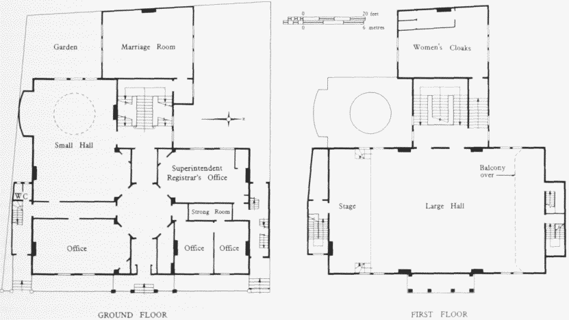
Town Hall, Newby Place, plans in 1939. A. & C. Harston, architects, 1870–1. Demolished
Messrs Arthur and Christopher Harston of East India Dock Road were appointed architects. The Trustees made a number of alterations to the designs, including the removal of the wooden clock turret: the decision not to have a clock made the turret 'of doubtful necessity'. (fn. 42) The tender of Adin Sheffield of East India Dock Road for £7,479 was the lowest received and was accepted. (fn. 43) Completed by October 1870, the building was officially opened on 27 April 1871. (fn. 44) The cost of the Town Hall and All Saints' infants' school was £10,462 2s 9d, including furnishings and repairs to the rector's summerhouse. (fn. 45) This was funded by the £10,000 received from the Guardians and the accrued interest. The Trustees declared themselves satisfied with their new Town Hall, but the builder let it be known that his contract had not been financially advantageous. (fn. 46)
The building was of stock bricks and had a frontage of yellow malm brickwork, a cornice of Portland stone, and coupled polished red granite columns with carved capitals (Plate 35b). Its style was eclectic, being described by contemporaries as both 'French Renaissance' and 'Italian'. (fn. 47) It was of two storeys with a basement, and was surmounted by an ornamental parapet. Portland stone was also used for the advanced central section of the street front, which had a loggia on the first floor supported by six caryatides sculpted by Mr Seale (presumably J. W. Seale of Walworth). The ground floor was entered through a vestibule beneath the loggia, which led to an octagonal central hall, and contained a board room and committee rooms, the offices of the parochial officials and a public reading room. A further vestibule gave access to the main staircase, which consisted of a central and two return flights, and two separate staircases led from the ground floor to the gallery and the rear of the hall. (fn. 48) The public hall on the first floor was 70ft long, 40ft broad and 26ft high, lit by 14 windows, and with a gallery which could seat 100. (fn. 49) Its four open fireplaces had chimneypieces of carved Painswick stone. The basement contained the housekeeper's and muniment rooms. (fn. 50)
Because the building was used for public events, some internal alterations were made for safety reasons in 1890. Foremost amongst these was the construction of separate staircases to the hall and the gallery, to replace the existing single gallery staircase at the north-eastern corner of the hall. (fn. 51) Other changes made at the same time included the strengthening of the principal staircase. (fn. 52) The hall tended to become overcrowded during public lectures and concerts and so in 1922 the balcony's supports were strengthened. (fn. 53)
By 1895 it was apparent that the accommodation was inadequate. The solution devised by William Clarkson was the enlargement of the rate collectors' office to form a new room for the use of the Trustees and Vestry and other small meetings, the adaptation of the existing committee room to accommodate the collectors, and the provision of a new committee room of 28ft by 22ft by building over the school playground adjoining the hall. New cloakrooms and lavatories were to be built in the basement and on the first floor. (fn. 54) There were some delays before, in 1898. J. H. Johnson was appointed contractor. (fn. 55) The cost of the alterations was £3,105 18s. (fn. 56)
After the termination of the Trustees' administration in 1900, the offices were occupied by the rates departments for the southern division of the new borough. (fn. 57) In 1938 the building was renamed the 'Poplar Public Hall' on the opening of the new town hall in Bow. (fn. 58) Most of the Council's officials were transferred to the new town hall and the offices in the Newby Place building were vacated. Three of the ground floor rooms were subsequently adapted for use by the Superintendent Registrar, the committee room on the half landing serving as the marriage room (fig. 65). (fn. 59)
The building was set alight by incendiary bombs during the large-scale air raid on 7 September 1940. As the raid occurred on a Saturday afternoon, the building was empty and securely locked, and so the spread of the flames could not be checked. It was so badly damaged by the fire that the ruins were later demolished. (fn. 60)
All Saints' School (demolished).
The first school building was erected by the vestry in 1846 on a strip of land at the south end of the rectory garden. Thomas Bazeley, the rector, also made a substantial contribution towards the cost of the building. (fn. 61) The architect was John Morris. The schoolroom was 50ft by 25ft. (fn. 62) In 1862 its capacity was put at 250 infants and girls. (fn. 63) John Gates bequeathed £200 to the school in his will, which was proved in 1864. (fn. 64)
In 1869 an agreement was reached with the Trustees of the parish that the school should be reconstructed on a part of the rectory garden, with a plot of land behind the town hall transferred to the rector and used as the school's playground. (fn. 65) The new school was completed in 1870, with two schoolrooms, each 50ft by 25ft, and two smaller classrooms. (fn. 66) Presumably, it was constructed by Adin Sheffield, the builder of the town hall (see above).
In 1871 there were 200 pupils, who were infants of both sexes and some older girls. (fn. 67) A reorganization carried out by Arthur Chandler, the rector, in 1894 removed the 'anomaly … of having two schools of precisely the same nature fronting each other at opposite sides of a square' by making the Newby Place building the infants' department and transferring the girls to the Bow Lane school (see page 194). (fn. 68)
In 1904 the school was surveyed by the LCC and some defects were pointed out, particularly the lack of a separate room for the teachers' use. The report was critical rather than condemnatory, but upon consideration it was decided that the building was unsuitable for elementary education. It was closed on 30 November 1906 and demolished before December 1909. (fn. 69)
All Saints' Institute (demolished).
Following the closure of the All Saints' school building, it was decided to use the site for a parish institute. The plot was enlarged by the incorporation of yet another strip from the rectory garden. (fn. 70) The foundation stone was laid by Princess Beatrice in the autumn of 1910 and the building was formally opened by the Bishop of London on 1 July 1911. Designed by William Clarkson, a churchwarden of All Saints' and a partner in the firm of J. & W. Clarkson, it was built by Messrs H. F. Higgs of Loughborough Junction, at a cost of approximately £5,000. (fn. 71)
The Newby Place front was of Portland stone and red bricks. The ground floor contained a gymnasium, a billiard room and clubrooms, and there was a hall on the first floor which could seat 350–400, with a stage, and a pitch-pine boarded floor (fig. 66). (fn. 72)
On Saturday 7 September 1940, when the adjoining town hall was gutted by fire bombs, the Institute, then occupied by men of RAF Balloon Command, was saved by the use of water brought from Poplar baths. (fn. 73) Nevertheless, wartime damage was such that the building was deemed to be beyond repair and was demolished in 1961 by the Borough Council, which had bought the site. (fn. 74)
Mountague Place
Mountague Place was laid out along the south side of All Saints' churchyard in 1822. (fn. 75) James Mountague (c1776–1853) was the younger son of William Mountague (d.1791), and, like his father, worked in the office of George Dance, the Surveyor to the City of London. (fn. 76) In 1805 he was appointed as Surveyor and Superintendent of the City Canal and he subsequently moved to a house in Coldharbour. (fn. 77) He became involved in local administration in the early 1810s and, with the support of the dock companies, was appointed treasurer of the Trustees empowered by the Improvement Act of 1813, presumably to counter the spendthrift tendencies of the locals. (fn. 78) He was also chosen treasurer to the vestry on its creation in 1817 and was selected as the rector's churchwarden. (fn. 79) A dominant figure in local affairs, Mountague retained his administrative positions until his death in 1853, although he left the parish following the Corporation's sale of the canal in 1828. (fn. 80)
The south side of Mountague Place was divided into 12 building lots. The sites of Nos 4–12 were auctioned by the vestry in 1823, those of Nos 1–3 by the Church Commissioners in 1826. (fn. 81) The houses were built shortly after the sales of the land; the Land Tax was paid on eight houses in 1823 and on nine in 1824. (fn. 82) Nos 1–3 were added following the Church Commissioners' auction. The sites of Nos 4 and 5 were acquired by David Durran, gentleman, of St Martin's-in-the-Fields, (fn. 83) and those of Nos 11 and 12 by John Stock, the local school proprietor and prominent member of the vestry. The remaining lots were developed as single units, hence the irregular appearance of the surviving houses (fig. 67). Some uniformity was given by the covenant in all of the sales that only an open railing or steps to the houses could be erected upon a strip of ground 6ft wide running along the entire frontage (Plate 36a).
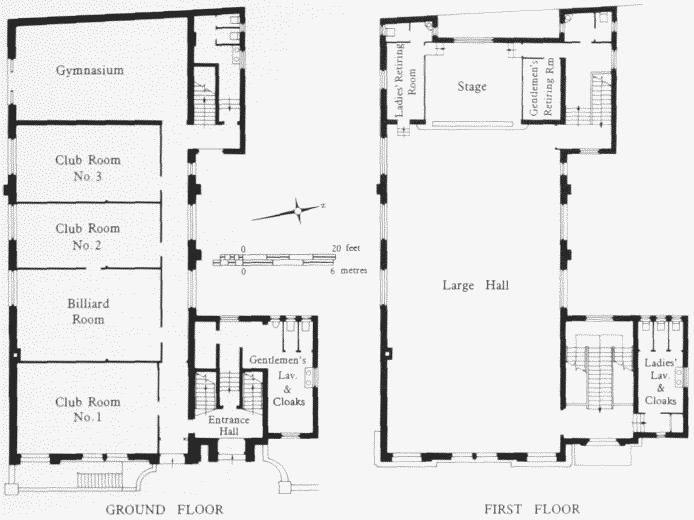
All Saints' Institute, Newby Place, plans. William Clarkson, architect, 1910–11. Demolished
The houses consist of three storeys above a basement, except No. 8, which has four storeys. Nos 11 and 12 were apparently built with attic rooms; (fn. 84) those in Nos 5, 6, 9 and 10 are later additions. The vaulted cellars built under the street pavement could be put to a variety of uses. In 1866 the Rev. C. R. Holmes made an indignant complaint to the District Board of Works that three bottles of wine were destroyed in his cellar at No. 10 when the pavement was repaired. (fn. 85) There is a well in the basement of No. 7 and others may have had wells that are now covered over.
Although Nos 1 and 2 were erected by different owners, respectively James Gordon and William Horne, (fn. 86) and were initially held separately, by the late 1840s they were both occupied by George Baillie, a doctor, whose considerable household comprised, in 1851, himself, his wife and six children, a medical assistant, a coachman and three servants. (fn. 87) The two houses continued to be used as a single unit thereafter. They were occupied by the Nursing Sisters of St John the Divine in the 1880s, briefly by the Christ Church Mission at the turn of the century, and served as Poplar Synagogue between 1904 and 1923. In 1924–5 Nos 1, 2 and 4 were acquired by the Borough Council and converted into tenements. (fn. 88)
The site of No. 3 was bought by John Oliver, a local builder, together with a leasehold plot to the rear which was 146ft long and 26½ft at its widest point. (fn. 89) Access to this rather awkwardly shaped plot was by a passageway between Nos 3 and 4. It was occupied by stables and later by workshops which during the early twentieth century were used by a wholesale clothiers and, by the 1930s, by a bakery. (fn. 90) Nos 1–4 were demolished following bomb damage during the Second World War.
The remaining houses, Nos 5–12 (listed Grade II), are of yellow stock bricks. Their ground floors have a mixture of arched and square-headed windows. Those on the upper floors are predominantly square-headed, although there are exceptions at Nos 6, 7 and 8, and further variety is added to the appearance of the frontages by the iron balconies at Nos 6 and 10. The frontage of No. 7 differs somewhat from those of the other houses in the row, chiefly because of its single-arched windows on all three floors. The doorways of Nos 5–11 are round-headed, but with considerable variety in their brickwork detailing. The houses have side halls and staircases, with two rooms on each floor; the front rooms on the upper floors occupying the full width of the houses. The entrance to No. 12, which has a Greek Doric porch with an entablature, was placed in Bazely Street, thereby allowing the front room on the ground floor to occupy the whole of the frontage on to Mountague Place. There was a similar arrangement at No. 1, the entrance of which was in Newby Place, and it, too, had an elaborate porch. The original pillars supporting the porch of No. 12 were removed c1991 and replaced by facsimiles when the building was converted into flats in 1992.
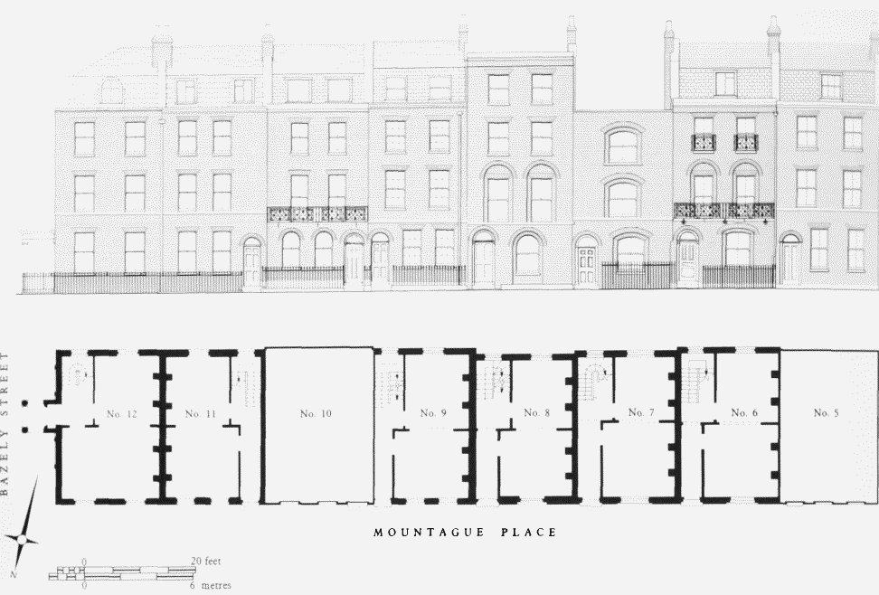
Nos 5–12 Mountague Place, front (north) elevations in 1987, and ground-floor plans of Nos 6–9 and 11–12 as presumed built
The siting of the houses attracted members of the professions. As well as the doctor at Nos 1 and 2, No. 12 was occupied by doctors from at least 1845 until the early 1980s. The garden to its rear, along Bazely Street, provided a site for a surgery. A rear extension at groundand first-floor levels was first added, apparently to contain the staircase, which had been awkwardly placed in the original, rather constricted, hall. In 1863 a range containing a surgery, consulting room and waiting room was built by Reader & Mitchell of Grundy Street. The rooms faced the garden, and a separate entrance was provided from Bazely Street. (fn. 91) Doctors and surgeons also occupied No. 6, from the 1870s until the 1930s, and No. 5, which has a surgery to the rear, from the 1920s. (fn. 92)
The Place has also provided convenient residences for clergymen and other members of the parish staff. Nos 6 and 11 were acquired by the London Diocesan Fund for the purpose and No. 10 was occupied by members of the clergy from time to time. In the early 1950s All Saints' had a large team ministry and a total paid staff of 14. (fn. 93) In addition, the Sisters of the Community of St Denys occupied No. 11 from 1917 until 1962 and the Sisters of the Charity of St Vincent de Paul occupied No. 7 from 1932 until 1967. (fn. 94)
Bazely Street, west side
The land on the west side of Bow Lane (Bazely Street) and north of the Esther Hawes almshouses was part of that auctioned by the vestry in 1823.
The northernmost two of the seven lots were acquired by John Stock, and the Greenwich Pensioner public house was built upon them in 1827 by James Hammack of Mile End (Plate 40a). The name of the public house has not changed since it was licensed in that year. (fn. 95) The building, which is listed Grade II, is of two storeys over a basement. The ground storey of its front façade is tiled and has three double doors; the upper storey front has three rectangular windows set in large round arches. There is a valley roof, with a stucco cornice and parapet. The rear additions date from the late nineteenth century. (fn. 96)
Immediately to the south of the Greenwich Pensioner, No. 4 was built on a lot sold to John Garford in 1823. Part of its upper storey extended over the gateway which led to the public house's yard. There were stables and outhouses to its rear. Nos 6–10 (even) were the houses known as Surrey Place, built on three lots acquired by Thomas Garrett and William Morgan, both shipwrights of Cotton Street. (fn. 97) They were small houses containing six rooms, on basement, ground and first floors, and rear wash-houses. (fn. 98) A fourth house at the southern end of Surrey Place was built on a lot acquired by Timothy Wood, a cornfactor of Poplar High Street. It was occupied by a shoemaker and his family in 1861, but was demolished by 1867 and was not rebuilt. (fn. 99)
To the rear of Surrey Place was a terrace of three houses known as Surrey Court or Surrey Place West, approached by a passageway between Nos 6 and 8. They contained four rooms each, on two floors. In 1933, when they were investigated by Poplar Borough Council's officers, they had a total of 17 occupants. Conditions were so bad that a demolition order was issued in 1934 and the houses had been cleared by 1937. (fn. 100)
The other houses, Nos 4–10 (even), were badly damaged by bombing during the Second World War and their sites were cleared, leaving only the Greenwich Pensioner from the original development of this part of the street.
The Esther Hawes Almshouses (demolished).
These almshouses were established by Esther Hawes for the accommodation of six elderly and poor Poplar women. Esther Hawes was the daughter of Henry Hall of Blackwall, who died in 1659 and bequeathed to her an annuity of £10. (fn. 101) In 1644 she married John Craven of Shadwell and, after his death, in 1670 Thomas Hawes of Hertfordshire. (fn. 102) She had been widowed again by 1685, when she bought five tenements with a garden and threequarters of an acre of ground near Poplar Chapel as an endowment (see page 64). (fn. 103) In the following year she acquired the land on which the almshouses were erected. The site was approximately 50ft from north to south and had formed part of two gardens attached to houses in the High Street. (fn. 104)
There were two single-storey ranges, each of three almshouses, facing each other across a courtyard (Plate 34c). Access was by a brick doorway from Bow Lane (Bazely Street). An inscription over the doorway stated that the almshouses were built in 1686, the year in which Mrs Hawes purchased the ground. (fn. 1) The houses, each of a single room, were of brick, with tiled roofs, hipped towards the street and gabled at the west end. They were served by a pump in the centre of the courtyard. In the late nineteenth century there was a semi-octagonal building of uncertain date against the western wall which contained two closets; this collapsed at some stage and was replaced by a lean-to structure. (fn. 105)
The endowment specified in Esther Hawes's will provided a yearly pension of £1 10s for each of the occupants of the almshouses, £1 for an annual sermon on Whit Monday and also the costs of repair and maintenance of the buildings. (fn. 106) In 1730 proceedings were begun in Chancery to compel Mrs Jane Platt, the holder of the property providing the endowment, to supply the means to keep the almshouses in repair. (fn. 107) From the 1790s this property was held by the Stock family, (fn. 108) and in the mid-nineteenth century the owners were reminded of their obligations, for by the early 1850s the almshouses had been allowed to fall into 'a very dilapidated state … unfit for habitation'. (fn. 109) In 1863 the Medical Officer of Health found them to be damp and in need of cleaning and limewashing. (fn. 110) Alterations carried out at approximately that date included the replacement of the leaded lights by small wooden casements with glazing bars. (fn. 111) Repairs made in c1930 involved repointing and reroofing with modern tiles. (fn. 112)
By 1933 the almshouses were threatened with demolition because of Poplar Borough Council's scheme to clear slums in Commodore Court to the west and the properties along the western side of Bow Lane. There were related plans to widen that street and the almshouses projected so far forward from the proposed new building line as to constitute a potential traffic bottleneck. (fn. 113) The Society for the Protection of Ancient Buildings was contacted by G. N. Kent, an architect and surveyor of Plaistow, who thought that the almshouses should be preserved. He received support from J. E. M. Macgregor, the Society's architect, who agreed that there were so few seventeenth-century buildings in the area that the almshouses should be saved if possible, although an LCC memorandum of 1937 noted that the buildings were 'not of sufficient architectural interest' to call for 'special steps' to preserve them. As Kent himself admitted, the buildings stood in the way of a 'real improvement', and new, pleasanter and more sanitary almshouses could be built elsewhere. (fn. 114) Arrangements were made to rehouse the four remaining occupants and invest the receipts from the sale of the land in the newly constituted pension charity, which had superseded the arrangements made by the founder. (fn. 115) In 1938 the almshouses were sold to the Borough Council for £250, but the Second World War delayed their proposed demolition, and, despite some bomb damage, they survived and in 1945 were being used for storage. (fn. 116)
The arguments for and against their preservation rehearsed during the next few years were similar to those put forward in the 1930s, with the added dimension of their possible listing under the Town and Country Planning Act of 1947. (fn. 117) The physical condition of the almshouses had further deteriorated, however, and by January 1953 they were described as being derelict. (fn. 118) They were demolished before the end of June 1953. (fn. 119)