Survey of London: Volumes 43 and 44, Poplar, Blackwall and Isle of Dogs. Originally published by London County Council, London, 1994.
This free content was digitised by double rekeying. All rights reserved.
'The Isle of Dogs: Introduction', in Survey of London: Volumes 43 and 44, Poplar, Blackwall and Isle of Dogs, (London, 1994) pp. 375-387. British History Online https://www.british-history.ac.uk/survey-london/vols43-4/pp375-387 [accessed 19 April 2024]
In this section
CHAPTER XIII - The Isle of Dogs: Introduction
The Isle of Dogs before the Industrial Revolution
The Marsh and the Marsh Wall
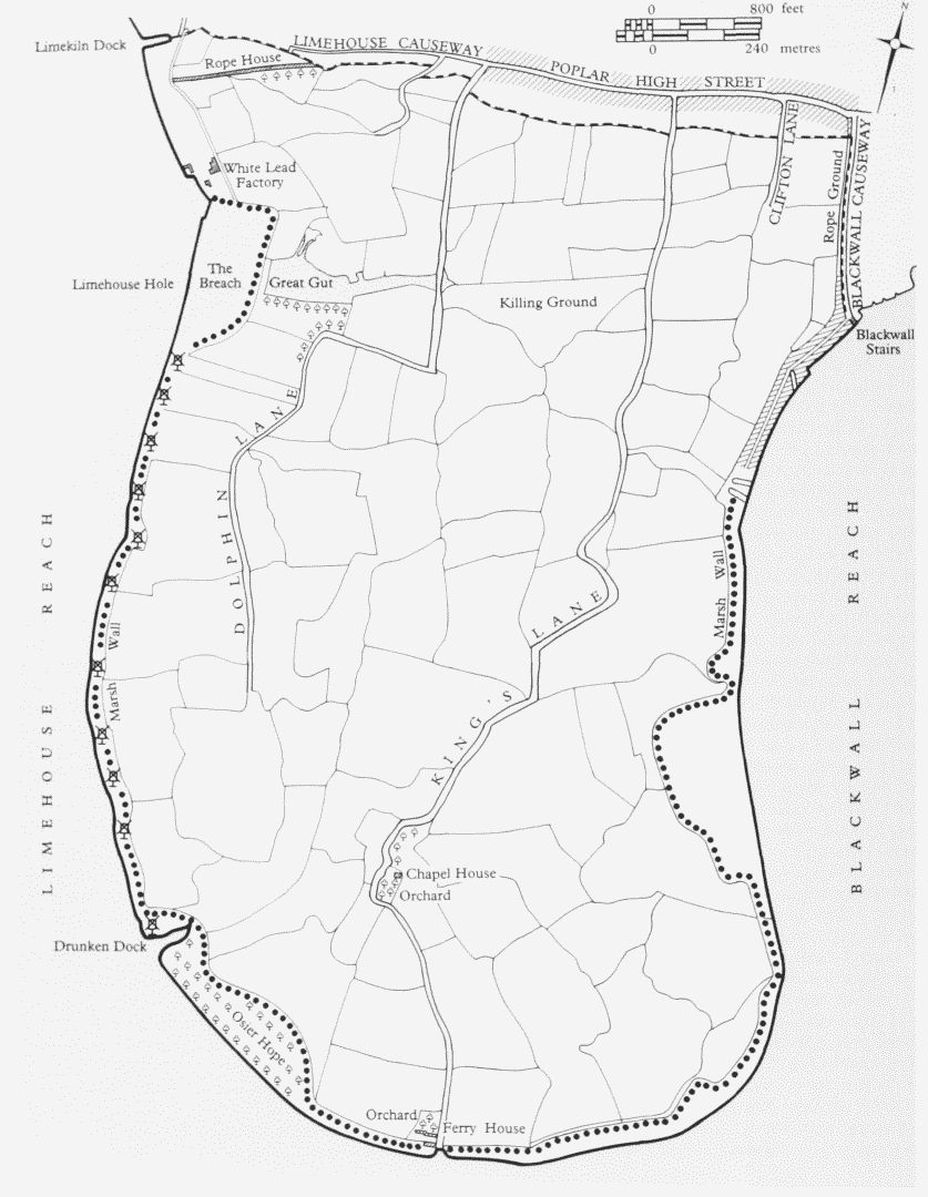
Lying where the Thames 'fetcheth almost a round compasse with a great winding reach', (fn. 14) the Isle of Dogs is unique among London districts for its watery boundary (Plate 68b,). Known locally since the nineteenth century as the Island, it is a tongue of reclaimed land made into an island by the West India Docks. The soil is alluvial, underlaid by clay or mud, and in places treacherous for building on account of a peat layer. A survey of 1646 recorded the Isle of Dogs as covering 757 acres; (fn. 15) another, in 1740, gave its extent as 836 acres. (fn. 16) Embanking and straightening of the river front have – disregarding the incursion of the docks – slightly increased its size (fig. 139).
Before development the land was marsh, lying several feet below high water level. Protected from flooding by a bank or wall, it was drained by large ditches discharging into the river through sluicegates. It has been suggested that reclamation was carried out by the Romans, (fn. 17) but a medieval date is more likely. (fn. 1) Another part of Stepney marshes, at Shadwell, was reclaimed before the fourteenth century by the lord of the manor, who granted parcels of the land to his freemen on condition that they each kept their banks and ditches in shape. (fn. 19) The earliest reference to the repair of the wall and ditches of the Isle of Dogs dates from the end of the thirteenth century, (fn. 20) but a settlement existed well before this, so there must already have been a wall. Repeated drownings and reclamations probably involved its partial reconstruction or enlargement.
Made of earth, or earth and chalk, possibly with a timber core in places (faggots were used in the seventeenth century to stop up large gaps), (fn. 21) the wall varied in section. In the narrowest parts, where it was more than 15ft high, the flat top was about 18ft across; slopes to both river and marsh gave an overall width of up to 150ft. (fn. 22)
Successive Royal Commissions were appointed to survey and maintain the wall, and following a flood in October 1629 responsibility for its upkeep was given to a permanent body of Commissioners of Sewers for Poplar, who, with a jury of marshmen, constituted a court with powers to regulate activities impinging on the wall and the drainage of the marsh. Repairs were financed by a rate levied on landowners. (fn. 23) From then on, no doubt according to established practice, the wall was protected from erosion by chalk lumps spread over the foreshore, retained by timber foot-wharfing, and timber 'breasting' and coping higher up the bank. (fn. 24) By the late eighteenth century, Kentish ragstone was used in place of chalk on occasion. Chalk seems also to have been the usual material for repairs to the wall itself, being used by the Ironmongers' Company, for instance, to patch the wall on its Barnfield Estate in 1811. (fn. 25)
As this example shows, repairs could be undertaken by landowners on their own initiative (though, in the case of the Ironmongers' Company, this seems to have been an isolated instance). A protective 'horse-shoe' earthwork is known to have been made by the 1560s on riverside land belonging to the Queen. (fn. 26) Despite the rate, it became customary for owners or occupiers along the west bank, or Mill Wall, to undertake repairs at their own expense, usually by direction of the commissioners. Millwall leases generally included covenants on the part of the lessee to carry out such works. (fn. 27)
Breaches occurred at Saunders Ness in 1652 and, more seriously, to the south of Limekiln Dock, in March 1660. In the second case, brought about by ballast-digging on the foreshore, several acres were lost to the river and a large pond or 'gut' formed. The owners ceded their rights in the drowned land to the commissioners and were recompensed accordingly. (fn. 28) The Breach and the Gut remained until the construction of the City Canal.
Pomfret Manor, St Mary's in the Marsh and the Chapel House
The first clear evidence of settlement dates from the second half of the twelfth century, when William of Pontefract built a chapel on his estate, later known as the manor of Pomfret (otherwise Pountfret, or variants). (fn. 29) Pomfret was a hamlet with about 80 acres of arable land and a windmill. (fn. 30) In 1322 it had cornfields worked by 12 villeins, (fn. 31) but by 1362 the manor house was in ruins, (fn. 32) perhaps part of a general process of decay.
The earliest reference to a chapel in the marsh dedicated to St Mary dates from 1380. (fn. 33) This chapel may have been the old one, or perhaps a new chapel of ease had been erected for the marsh-dwellers: such a chapelry was founded in Stratford-at-Bow, Stepney, in 1311. The theory that it was an outpost of the Abbey of St Mary of Graces is founded on nothing more than the fact that the abbey owned land locally. Suggestions that it was a hermitage or penitent's chapel are romantic guesswork. (fn. 34) Repairs were carried out in 1415, and bequests were made to it until the mid-fifteenth century. (fn. 35) On Lady Day 1449 the river burst through the wall opposite Deptford, (fn. 36) and it was almost certainly this flood which led to the hamlet's abandonment.
The Isle of Dogs c1740
Thomas Kempe, Bishop of London from 1448 until his death in 1489, recovered nearly 500 acres of the marsh, obtaining a 94-year lease of the land from commissioners appointed by Edward IV to oversee the walls and ditches. Flooded once more, the land was again reclaimed by sublessees of Kempe, but in 1529 it was once more under water. (fn. 37)
Further evidence of waterlogging is given in the Stepney Manor accounts, which record the receipt of 46s 8d in 1464–5 for 'fishing and fowling' in the marsh. (fn. 38) A century later, the greater part of Stepney Marsh was said to yield no revenue, but, at 1,300 acres, it covered a much greater area than just the Isle of Dogs. More than 100 acres produced a paltry 8d an acre; 282 acres were let at nearly three times as much, but even this was a fraction of the estimated rack rent. If this valuable marshland was in the Isle of Dogs it would suggest that it was already becoming known as rich pasture.
The site of the hamlet was still apparent until the making of Millwall Docks. As well as traces of demolished buildings, part of the chapel survived as the lower walls of the Chapel House; 'rude work' of large rubble stones with chalk, tile and stone infilling. It retained a pointed window until the late eighteenth century. (fn. 39)
When the chapel became a dwelling is uncertain, but the name Chapel House was in use by the late sixteenth century. (fn. 40) Gascoyne's 1703 map shows simply 'the Chappell'; Maitland refers ambiguously to 'the Chapel-house … the Ruins of a Stone Chapel'. (fn. 41) Part may well have been in ruins, for in 1799, the owner, a Limehouse attorney, mentioned that a weather-boarded timber addition had been made to the building about 30 years before: this work appears to have involved the roofing-in of ruined stonework. (fn. 42) By 1811 the building was a 'neat farm-house'; a few years later the then occupier, a grazier and horse dealer, largely rebuilt it in brick on a long lease from William Mellish, afterwards making it into two dwellings. (fn. 43) Two or three 'mean and inconvenient' tenements were later built on to it. (fn. 44)
Pictorial evidence is slight. Buildings in a wooded area are indicated on several distant views from Greenwich, the earliest being Anthony van Wyngaerde's 1558 drawing of Greenwich Palace from Greenwich Park. (fn. 45) Jan Vorsterman's 'Greenwich from One Tree Hill', painted about 1680, (fn. 46) however, shows a gabled house or house and barn with small cottages or sheds to the north. A less distinct view, painted by Adriaen Staelbent about half a century earlier, is broadly similar. (fn. 47) The well-known view by Robert Griffier (1688–? 1760) shows a substantial house of several bays, with a hipped red-tiled roof. (fn. 48)
The house seems to have occupied a moated site – no doubt that of the ruined manor house – south of the Chapel House. Of unknown date, it may have incorporated the old structure to a greater or lesser extent. In 1512–13 it was acquired on an 80-year lease by Thomas Knight, citizen and brewer of London, from the Bishop of London. (fn. 49) Norden's Map of Middlesex (1593) shows the house as having the status of a gentleman's or knight's residence. It was still standing in the late 1650s, when it belonged to Sir John Yate's estate, but in 1742 the site was described as an acre of ground 'heretofore called the Isle of Dogs whereon a house heretofore stood and is now called the Orchard, and is surrounded by a large ditch or mote'. (fn. 50)
Some years on, Maitland wrote of 'large foundations and gate hooks' near the Chapel House, which he believed to have been the remains of the capital mansion of Pomfret, and by 1774 a site adjoining, formerly known as the Foreyard or Barton, had acquired the name of 'the Stone House grounds'. (fn. 51)
It has been wondered whether the house belonged to the manor in Poplar where the Black Prince once lived, (fn. 52) and it is just possible that a vague tradition of a royal connection survived into the nineteenth century. 'But, master, have you seen King John's Castle yonder?' an Illustrated London News journalist was asked by a local man in 1857. (fn. 53)
The only other building known to have existed on the Isle of Dogs before the seventeenth century is a watergate at Potter's Ferry. An archway with flanking towers, it is shown indistinctly on van Wyngaerde's sketch and on a map of c1573. (fn. 54) No other evidence of it is known.
The Isle of Dogs and Other Names
Robert Adam's Thamesis Descriptio of 1588, (fn. 55) which shows the south-western part of the peninsula (fn. 2) as the Isle of Dogs, is thought to be the earliest map to use the name. It was in use well before that, however, for in 1520 one of several vessels prepared for carrying the royal household to and from Calais was docked at 'the Isle of Dogs', (fn. 57) perhaps at Drunken Dock. It is often unclear from mentions of the Isle of Dogs in the sixteenth and seventeenth centuries whether all or part of the peninsula is meant. Isle of Dogs Farm, shown on Norden's map of Middlesex, appears on as late a map as Ogilby and Morgan's Country About 15 Miles any Way from London of 1683. Jonas Moore's Thames survey of 1662 shows the same south-western area as the 'Isle of Dogs', distinct from 'Blackwall March' to the north and what is now Cubitt Town. Andrew Yarranton, however, in his 'fishing city' scheme of 1681 (see page 387), speaks of 'the Isle of Doggs, or Blackwall-level, An Isle seated in the Thames'. (fn. 58) Title deeds (fn. 59) show that Isle of Dogs was the name of the farm and house probably originating as Pomfret manor (see above), but it may have been loosely applied from an early date to the district generally.
A number of late Elizabethan and Jacobean allusions to the Isle of Dogs show only that the name – or the phrase – had some popular currency. It was the title of a notorious satirical play of 'very seditious and slandrous' content, written by Thomas Nashe in collaboration with Ben Jonson and others, and performed at the Swan Theatre by the Earl of Pembroke's Men in 1597. Now lost, the play was outrageous enough to lead to Jonson's imprisonment and Nashe's fleeing London. The Isle of Dogs of the title, however, was no doubt a metaphor for Britain, rather than an indication of a marshland setting. (fn. 60) Punning references to the Isle of Dogs occur in Dekker and Middleton's The Roaring Girle, or Moll Cut-Purse of 1604–10 and in a play by Beaumont and Fletcher of about the same date. (fn. 61)
That the Isle of Dogs was something of a byword is further suggested by a remark made during the trial for blasphemy of the quaker James Nayler in the House of Commons in 1656. Suggested places of confinement had ranged from the Scilly Isles (where the Unitarian heretic John Biddle had been banished the year before) to Jamaica, when Sir Thomas Wroth – who had earlier demanded Nayler's death – threw in the Isle of Dogs, apparently in facetious exasperation. (fn. 62)
Yet the Isle of Dogs does seem subsequently to have acquired some penal connotation. Rocque's map (1746) shows gibbets on the riverside, while in Hogarth's depiction of the Idle Apprentice's departure from London to become a seaman, as he is rowed down Limehouse Reach it is towards a hanged man on the Isle of Dogs that one of his companions points. The windmills lining the bank made an ideal backdrop, symbolic of the slow-grinding mills of God.
It has been said that pirates were hanged in chains on the foreshore opposite Greenwich Hospital, where the pensioners would hire out spyglasses to interested visitors, and the macabre tradition that hangings occurred on the Isle of Dogs continues. (fn. 63) A late-eighteenth-century Thames guidebook mentions three gibbets in Blackwall Reach 'upon which have been hung persons who have committed murders on the high seas'. These were, however, on the south side of the river, roughly opposite the Folly House. (fn. 64)
It may have been the lugubrious reputation of the Isle of Dogs, as much as its desolate terrain, which inspired the melancholic Thomas Davers to erect his folly there in the 1750s (see page 536). Davers, the unlucky scion of 'an ancient and honourable family', committed suicide in 1767, but had been forced by poverty to surrender his mock fortress soon after building it. (fn. 65)
Perhaps 'the unlucky Isle of Doggs', as Samuel Pepys called it, (fn. 66) had well-known untoward associations. But how the name originated remains an enigma. Among several, mostly fanciful, theories, the most persistent is that royal hunting dogs were kept there when the king resided at Greenwich Palace. Versions of the story probably all derive from Strype's Stow's Survey of London; no evidence for it has ever been adduced. The word 'dog' has acquired so many allusive usages that many rival suggestions might be made, but the legend is not entirely implausible. Coined by 1520, the name does not appear to have been given in a lease of the farm later called Isle of Dogs in 1512–13. (fn. 67) Deer for hunting were kept in Greenwich Park by Henry VIII from 1515. (fn. 68) By this time it is likely that the flood-prone marshes were used largely as pasture by non-resident graziers, and it is therefore possible that the farm buildings were under-used and, being isolated but easily accessible from Greenwich, made suitable kennels. (fn. 3)
The name may have arisen because the farm was at times an island in flood water, or amidst a quagmire, in which case its coinage may have been comparable to that of the long-lost name of Pruson (or Spruson's) Island in Wapping Marsh. Oddly enough, an occupier or former occupier of the farm, named in a sixteenth-century deed, was a yeoman called Brache: this being an old word for a kind of hunting-dog, it is possible that the name may have arisen partly as a pun or corrupt usage. (fn. 69)
The name had no official status until the creation of Isle of Dogs Neighbourhood, a district of the London Borough of Tower Hamlets, in 1987. The survival of the name despite its lack of formal standing is explained by its reinforcing the local sense of separateness.
Until its development in the nineteenth century, the Isle of Dogs was known in law as Stepney (anciently Stebenhethe or variants) Marsh, of which it was originally only part, or as Poplar Marsh, South Marsh or Poplar South Marsh; archaic terms include Wet Marsh or Wall Marsh. In the eighteenth and nineteenth centuries, its northern boundary followed the common sewer south of Poplar High Street, running east to Blackwall Causeway. On the east side of the marsh, it is probably the case that the area as far south as Coldharbour has always been regarded as belonging to Blackwall rather than the Isle of Dogs. The term Poplar East Marsh was also used by the late seventeenth century to refer to the eastern part of the marsh. (fn. 70)
The name Mill Wall came into use in the late eighteenth century (it is first used in the rate books in 1784), initially referring to the western marsh wall, where windmills stood. Later, the name was used for both the path on the wall and the district generally. By the 1840s, the one-word form was usual. As late as 1875, this part of the Isle of Dogs was listed in the streets section of the Post Office Directory under Millwall alone – although Westferry Road had existed for 60 years, and had long ago superseded the marsh wall path, parts of which had already been stopped up as development proceeded. The anachronism was no doubt perpetuated in deference to the occupiers of riverside wharves.
The local historian Cowper equated Millwall with the whole Isle of Dogs, but since the Millwall Docks were made Millwall has come to mean more or less the western half only; though the name has often been used loosely. The east side of the Island south of Blackwall, including ground outside William Cubitt's development, has come to be known generally as Cubitt Town. Other names have come and gone. C. C. Tooke's attempt to promote the name Tooke Town for his estate in the 1840s and 1850s proved unsuccessful. 'North Greenwich' has been used from the late nineteenth century for the area immediately opposite Greenwich, doubtless an imitation of North Woolwich (an outlier of Woolwich on the north bank of the Thames) inspired by the Admiralty's interest in the ground.
Since the late nineteenth century, defunct field names have been revived for streets and developments, such as Saunders Ness Road and Friars Mead. Stebondale Street recalls Stebonheath, but the rurality of Lockes Field is specious – the made-up name derives from Locke Lancaster & Company, the lead manufacturers.
Land Use before Development
The evidence suggests that arable farming came to an end in the fifteenth century, and possibly well before 1449 the land was used primarily for grazing. It is known that a butcher, Richard Bray, had an acre of arable land in the marsh in the early fifteenth century. (fn. 71) Various butchers held land in the marsh in the sixteenth century, including fields on the Bishop of London's estate. In 1587, William Redmar, Citizen and Butcher, obtained a 9½-year lease from the Mayor and Corporation of the City of London of 18 acres at a rent of £18 a year. (fn. 72) This may have been the same 18 acres the herbage of which was leased in 1673 by Sir George Marche of the Tower of London to a Limehouse yeoman, George Clifton, (fn. 4) for £31 10s a year, Clifton undertaking to mow any thistles, docks or burrs. In the later seventeenth and early eighteenth centuries this same ground was let to butchers, at double Clifton's rent. (fn. 73)
A report to Sir John Yate from his agent, Robert
Kinsman, in 1663, shows how flooding could be caused
by surface water draining off the northern upland. The
marsh, wrote Kinsman, was:
in a sad condition att present by reason of thistles & the last
greate rayne made such an extraordinary landfloode that it
broke through Poplar Towne into the Marsh and drowned some
of it … if this fair weather holds it will dry again in a week.
(fn. 74)
In time the district acquired a reputation as some of
the richest pasture in the country for horses and beasts
for slaughter, with powers of revitalizing sick animals.
One mid-nineteenth-century authority claimed that the
special properties of the marsh were due to brackish
water, which:
let in from the Thames at various points, and pervading the
ditches throughout the entire marsh, causes the cattle brought
from different parts to be scoured and cleansed, and has a
tendency to sharpen their appetite, whilst it improves and
sustains the healthy quality of the herbage; and the joint agency
has a most extraordinary effect on the cattle in fattening and
enlarging them, and otherwise rendering them fit for the
market. (fn. 75)
Sheep also benefited:
a butcher undertook to furnish the club at Blackwall, with a leg of mutton every Saturday throughout the year, that should weigh twenty-eight pound, the sheep being fed in the marsh, or he would have nothing for them; and he did perform it. (fn. 76)
Some beasts would have been slaughtered on the Isle of Dogs (a killing field was in existence by 1740), (fn. 77) others taken to the live cattle market at Smithfield. (fn. 78)
Grazing retreated gradually before development. James
Warmington, the Ironmongers' Company's tenant, complained in 1837 of trespassers taking short cuts across his
grass:
the nuisance has been increasing, ever since the time the Stones
were prepared for the New London Bridge in the Isle of Dogs,
when so many workmen were employed near the spot; I think
I may safely state, that an acre of Herbage is entirely spoil'd,
[and] the fences can never be kept in proper repair. (fn. 79)
But as most industry grew up on the riverside, and house-building was limited, it was only with the creation of the Millwall Docks that a pastoral character disappeared: as late as 1856, the district was still described as 'so valuable for pasture and grazing purposes'. (fn. 80) By 1867, throughout the whole parish, there remained just 13 acres of permanent meadow and 13 acres under crop. There were fewer than 60 cows or heifers, most of which were kept in yards – a fall of a third on the previous year, no doubt occasioned by the sudden economic slump. (fn. 81)
In addition to grazing, there was some vegetablegrowing, notably on the Charteris (Mellish) land north of Chapel House Street, where W. H. Bradshaw had a market-garden in the late nineteenth century. (fn. 82) A local man, born in 1869, recalled this ground producing cabbages and mangolds for the London markets. He also recalled sheep on the site of Glengall Road Board School in the early 1870s. (fn. 83) How far back this market-gardening went is not clear. Various pieces of ground were vaguely described as 'garden' in the Commissioners of Sewers' cadastre of 1817, and in earlier deeds and land schedules. (fn. 84)
The Windmills
It was said in the 1850s that 'when in other parts of London the wind is scarcely felt, it sweeps over this place with great strength'. (fn. 85) Even today, the Isle of Dogs is a noticeably windy place, and before development must have been ideal for windmills. Their number has been variously stated, seven being most often cited. Seven are shown on Gascoyne's map of 1703, and Seven Mills School was named by the Inner London Education Authority to commemorate them. (fn. 86) It was thought erroneously that they dated back to medieval times.
At the peak, in the mid-eighteenth century, there were 12 mills on the Mill Wall. There were also windmills north of these, at the lead works at Limehouse Hole and on the site of Union Docks; and there seems to have been a thirteenth mill somewhere in the marsh by the early to mid-1750s (Plates 145b, 146b). (fn. 87)
The earliest mill, built about 1679, was followed by five more in the 1690s and a sixth in about 1701. These were the seven mills of Gascoyne's map (fig. 1, page 3). Two more appeared in 1710–12, a tenth in about 1718– 19, an eleventh in 1730–1, and a twelfth about ten years later. One was pulled down in the 1760s, another in 1785. Most, however, seem to have survived until the end of the eighteenth century. By the early nineteenth century, several were defunct or demolished, and by the mid-century none remained in operation. Cowper notes the existence of the foundations of two or three, as well as the sail-less body of Theobald's Mill, the remains of which may have survived as late as 1884 when the site was swept by fire. (fn. 88)
The mills, which with two known exceptions were of post type with circular or polygonal seats, were used mostly for corn-grinding to begin with, but oilseedcrushing had taken over as the main activity by the late eighteenth century. Several were erected by millers and others living on the south bank of the Thames in or near Redriffe (Rotherhithe), and south-side men continued to be associated with several mills throughout the eighteenth century. There were already windmills on the Rotherhithe riverside when the first was built. (fn. 5)
First Mill and Mill Adjoining (Site of Price's Oil Works).
The First Mill – so called from its topographical position – was built on a 61-year lease of November 1730, granted by Thomas Hollis, citizen and draper of London, to Thomas Rawson, miller, of Poplar. Rawson had earlier obtained permission to build it from the Commissioners of Sewers, on providing £100 surety. The site, with 150ft of river frontage, covered three acres. (fn. 89)
The mill was no longer in Rawson's possession a couple of years later, and in 1735 it belonged to Nicholas Felton, miller, of Rotherhithe. A second mill, of smock type, was built on the site c1740. In 1746 Felton's widow assigned the lease to Robert Sanders and Benjamin Carvill, millers, of Rotherhithe and Kent respectively. (fn. 90)
In 1755 Carvill was described as a biscuit baker, of Limehouse, and by that time as well as the mills and their granaries, a brewhouse had been built. In 1770 the lease passed via Carvill's widow to a Greenwich baker, George Wigzell, who in 1774 also obtained the freehold – to the conveyance of which the Shadwell butcher Samuel Mellish, uncle of William and Peter Mellish (see page 418), was party. Wigzell granted a 40-year repairing lease of the dilapidated premises in 1783, at a rent of £50, to George Frost of Poplar, a victualler. Part of the property, with one of the mills converted for oil-milling, was sublet by Frost the following year to Vaughan Lindsell, esquire, of Poplar. (fn. 91)
As well as the oil mill, Lindsell's premises included a two-storey dwelling house with cellars, and a two-oven bakehouse and a granary. These last, 40ft by 30ft and 28ft by 14ft respectively, occupied the ground floor of a building, the upper parts of which were granaries used by Frost's tenant Gray (probably Alexander Gray, the City baker who held a lease of the Second Mill), who appears to have occupied the other mill. Gray and Lindsell had joint use of the riverfront. (fn. 92)
A couple of years later, in 1786, Frost disposed of the original lease to John Garford, the prominent local oil and seed broker. The corn mill apparently occupied hitherto by Gray was subsequently used for crushing oilseed by William Garford. In 1791 he obtained a new 61-year lease of the whole three acres, later assigning the lease to John Bowman, a City brandy merchant, who also acquired the freehold from Wigzell in 1795. Eventually, the premises became Sir Charles Price's oil mills, and the smock-mill seems to have been made into an oilrefinery, probably surviving until the site was redeveloped in the 1870s. (fn. 93)
Robert Batson's Estate: the 'Second Mill'.
This was built on a 99-year lease granted in March 1710 by the then freeholder William Lea, citizen and fishmonger of London, to Robert Smith junior of Stepney, miller, for a consideration of £10 15s and at a rent of £2. The 80ftwide site had a river frontage of 150ft. A peculiarity of the lease was a clause denying access from the rest of Lea's land, the intention being that the occupiers 'are to Goe to and Come from the same from off the River of Thames only'; a further covenant banned 'geese, ducks, turkeys, cocks, hens, or any other sort of fowls whatsoever' from the premises. (fn. 94)
Smith died about 1745, leaving the mill to his daughter, Rebecca, his nephew Charles Smith continuing to run it for some years. In 1764 Rebecca, the widow of a West Ham coal merchant, sold the mill, with its dwellinghouse, warehouse, kiln and granaries, to Edward Walford, a local miller, for £145. (fn. 95)
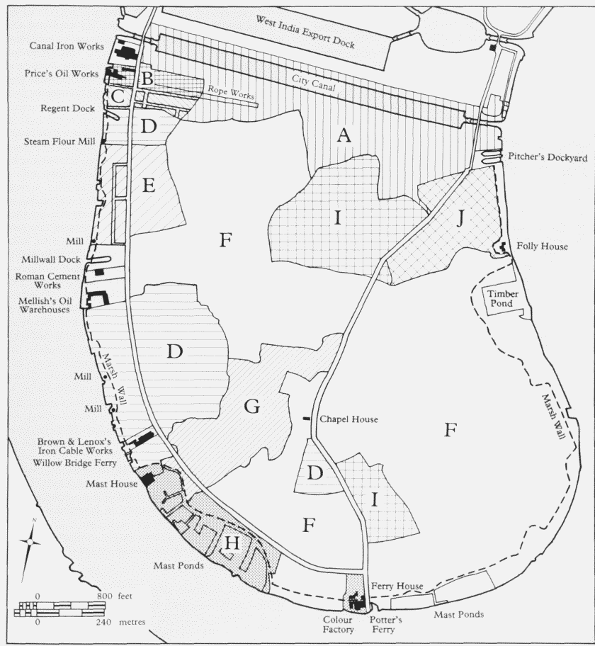
The Isle of Dogs c1820, plan showing the principal freehold land holdings Key to landowners: A Port of London Committee: B Sir Charles Price: C Robert Batson: D George Byng:E Rev. William Tooke: F William Mellish: G Ironmongers' Company: H Ferguson and Todd: I Earl of Strathmore:I William Stratton
Walford's administrator, Sarah Stiles of Ratcliff, granted a 21-year lease of the mill in 1778 to Alexander Gray, a Cheapside baker (see above), who in 1785 assigned it to John Hart, an oilman. (fn. 6) Hart sold it in 1789 for £800 to his creditor Timothy Stansfield, a tobacconist, of Lower Thames Street, and in 1798 Stansfield let it to John Bowman, who a few years earlier had purchased the First Mill. Bowman's lease expired in 1807, and it was probably then or soon after that the mill was pulled down. (fn. 96) (fn. 7)
George Byng's Estate in Northern Millwall: the 'Third Mill'.
Thought to be earliest of the mills, the 'Third Mill' was built c1679 on a 61-year lease granted by Henry Williams of Rotherhithe, victualler, to James Cutting, also of Rotherhithe, miller. The site was 65ft wide with a river frontage of 100ft, and the yearly rent was 10s. The mill appears on Gascoyne's map as 'Browns Mill', but it was later run by members of the local milling family, the Smiths. (fn. 98)
In 1785 George Russell and Thomas Uwins, the then proprietors, had it pulled down and the dock serving the mill filled in. (fn. 99) The mill-seat, however, was still standing in 1798, when George Byng leased it – with a muchenlarged site, giving a river frontage of 270ft – to Thomas Nairn of Wapping, baker. At 21 years, the lease was the longest possible under the terms on which Byng held the estate at that time. Whatever Nairn's intention may have been, the mill was never restored, and a few months later he assigned the property to Thomas Spratley of Ratcliff, a boat-builder. Spratley built a dock and put down ways for laying ships and boats for repair, and in 1805 he sublet part of the site to a Wapping anchor-smith for a workshop. (fn. 100)
Richard Chevall's Estate (Tooke Estate): Robert Smith's Three Mills.
Three windmills were built here in the 1690s, all on 99-year leases granted by Chevall to Robert Smith, a Rotherhithe miller, probably the Robert Smith later known as Robert Smith senior of Poplar. The first was built about 1690, the second about 1692 and the third about 1697. The last two, let at a halfcrown a year each, stood on similarly sized plots, each having a river frontage of 132ft and a depth of 70ft. The plot size and rent of the earlier mill were no doubt comparable. (fn. 101)
One mill, having become unsafe, was acquired in 1768 by a local carpenter, John Powsey, (fn. 8) presumably for renovation. With the mill were a house and a 40ft-square warehouse of two storeys with garrets. Powsey assigned the property after little over a year to William Kent, who had been running the mill for several years. In 1779 Kent also acquired the other two Smith mills, which remained in his family for some years. (fn. 103) At least one was a ruin in 1801, when its site was redeveloped as Mill Wall Foundry; the southernmost mill is shown as still functioning in a painting of 1811 (Plate 68a). (fn. 104)
William Mellish's Estate in Northern Millwall: Baker's Mill.
Baker's Mill was built on a 99-year lease granted in 1694 by the then freeholder, Edward Leeds, citizen and mercer of London, to a Rotherhithe miller, Nicholas Baker, at a premium of £22. With a river frontage of 134ft, the 60ft-deep site was comparable in size to those of other local mills. The rent was 10s plus 'one good sweet fat capon' or a half-crown in lieu (but compare the covenant in the lease of the Second Mill, above). The intended mill was exempted from the usual covenant to maintain any buildings erected. (fn. 105)
John Cooper the elder, a Poplar millwright, took over the lease of the premises (which included a house and granary) in 1768, but by 1770, when he and John Salter purchased the freehold of the estate, the mill had gone. The site later became the riverside portion of Mellish's Wharf. (fn. 106) (fn. 9)
George Byng's Estate in Southern Millwall: Chinnall's Mill.
The only one of three intended mills to be built on the ground in 1695, this was leased for 99 years to a miller called Luke Chinnall by John Lockey, the then freeholder. It is shown as 'Chinns Mill' on Gascoyne's map of 1703. The plot was similar in size to those of Robert Smith's mills to the north, built around the same time. In 1713, after Chinnall's death, his family sold the 'lately fallen down' mill to John Frampton of Westminster, baker, who disposed of it a couple of years later, apparently after restoration, to John Stiles, miller, of Blackwall Marsh. (fn. 108)
It seems to have remained in use until c1795, when cottages were built on the site by its occupier of some years, John Hart. (fn. 109)
The Ninth Mill
The Ninth Mill was built c1718–19 on a 99-year lease granted by William Lockey of Barking to William Chandler, gentleman, of Deptford. The rent of the ground, which had a river frontage of 200ft, was a half-crown a year. From 1762, when a later William Chandler, a farmer of East Ham, assigned his interest in the lease, the mill was held by a succession of Limehouse millers. One of these, Humphrey Wetton, also described as a corn chandler, dealer and chapman, occupied Chinnall's mill too from the mid-1770s, going bankrupt about 1797. (fn. 110) The mill was later run by a meal factor, Thomas Peacock, of Southwark and Shadwell, who in 1810 surrendered the property to George Byng for £800. It was still standing in 1816, when the much-reduced site was let on a short lease to a Rotherhithe shipwright, Thomas Seaton, at an annual rent of £45. He undertook to spend at least £75 erecting a cottage there.
Generally called the Ninth Mill, this windmill was also known as Tommy Tinker's or the Little Mill. Cowper seems to be confusing it with Chinnall's Mill when he refers to Churn's (that is, Chinn's) Mill, 'since called Tommy Tinker's'. (fn. 111)
Theobald's Mill
Theobald's Mill was built c1701 on a 99-year lease granted by John Lockey of Barking to Daniel Mayhew of Rotherhithe, miller. The site had a long river front of 290ft. William Peace, another Rotherhithe miller, acquired the lease in 1763 and in the following year Peace assigned it to an oil-presser, William Smith of Poplar. In 1788 George Byng granted a new 90-year lease of the site, including the mill, apparently rebuilt as a smockmill, to a Wapping biscuit baker, Murty Cullen, at a rent of two guineas. Mayhew's mill took the names of successive occupiers. It appears as Ward's Mill on Gascoyne's 1703 map, and a century later was known as Theobald's Mill. By this time part of the ground was a shipyard, and in the mid-1830s the site became Weston's cement and plaster works. (fn. 112)
Mill at Drunken Dock.
This, the southernmost of the Mill Wall mills, was built in about 1712, probably on a lease from the freeholder, Simon Lemon. It seems to have been occupied initially by John Stiles, who also ran Baker's Mill at this time, surviving until at least 1766. The site was later occupied by the Mast House (see page 467). (fn. 113)
The Isle of Dogs in the Nineteenth and Twentieth Centuries
The Poplar and Greenwich Ferry Roads Company
Proposals for a road from Limehouse to the Greenwich ferry went back to at least 1807, (fn. 114) and in 1812 the Poplar and Greenwich Ferry Roads Company was set up by local landowners and others, (fn. 11) and incorporated by Parliament with powers to ply a horse-ferry between Greenwich and the Isle of Dogs, and to make toll-roads to the ferry on each side of the river, including two on the north side (now Westferry and East Ferry Roads). (fn. 115)
Westferry Road was formerly called West Ferry Road (and originally was usually known as the Poplar and Greenwich Ferry Road). The contracted form, the use of which goes back at least to the 1920s, and is now universal and officially accepted, is used here throughout. Ord Street, running between Bridge Road and Westferry Road, was absorbed into Westferry Road in 1875 (though the tollgate remained), and in 1937 Bridge Road too was annexed.
The company scrapped its horse-ferry service in 1844, but tolls continued to be collected. Pressure for abolition of the tolls grew from the 1870s, and eventually the Metropolitan Board of Works obtained powers to buy out the company. (fn. 116) On 9 May 1885 there were celebrations as the toll-gates were removed. (fn. 117)
Development and Social Change
The formation of the ferry roads in 1812 15 opened up the Isle of Dogs for development. Ground fronting Westferry Road was being offered for building leases by early 1814. (fn. 118) There were hardly any takers: as a windswept marsh, the Isle of Dogs lacked potential as a residential suburb and development depended almost wholly on the growth of business on the riverside.
The Limehouse shipbuilder Robert Batson had formed a couple of streets on his estate in north Millwall a few years earlier. They were not conspicuously popular with house-builders. With Westferry Road under way, George Byng laid out streets on his land south of Batson's. Over the next few years several houses appeared, and a chapel on the Reverend Tooke's land further south, but building soon fizzled out.
On the riverside it was a different matter, and before long there were several workshops, factories, warehouses, cottages and larger houses, the northern part of the Mill Wall riverside becoming densely built-up during the next couple of decades, with an intricate pattern of leasehold interests. East of Westferry Road little more was built until the 1840s.
Riverside industrialization continued and by the midcentury the Isle of Dogs had become a thriving manufacturing district. A pattern of narrow wharves running from river to road (similar to wharves further up the Thames) was emerging in places. Some large sites, particularly along the south-west and east of the Island, were snapped up by the new breed of iron-shipbuilders and marine engineers – men such as Henry Wimshurst, builder of the first screw-propeller ship, the Archimedes. By the 1860s large shipyards were flourishing in Millwall and Cubitt Town. With the creation of the Millwall Docks, intended to provide yet more wharfage, prosperity seemed assured. In fact, over-confidence had forced the pace of growth which had, hitherto, been markedly organic.
Throughout the Isle of Dogs development generally was governed by the short-term demands of entrepreneurs. On many riverside premises there was almost continual change to boundaries and buildings. Housebuilding was mostly carried out piecemeal, by many builders. The process was most apparent in Millwall, partly because development began much earlier there, partly because of the disjointed nature of the landownership (fig. 140), and the sometimes awkward shapes of the freeholds. The Ironmongers' Company's Barnfield Estate, for instance, was almost impossible to develop fully without conjoint development of adjacent land. A further problem was that no big-time developer showed any interest, until William Cubitt saw the potential of the roadless marshes to the east in the early 1840s; there was nothing to give development a convincing take-off or an overall plan. Millwall and Cubitt Town were far from fully built-up when the financial crash of 1866 triggered the collapse of business confidence, devastating the Thames-side shipyards.
The Isle of Dogs that emerged after the distress of the late 1860s was solidly working-class. Residential, or largely residential, areas, served by innumerable small shops and licensed premises, were sandwiched between the docks and wharves which together provided most local employment. Poor, but a hotbed neither of crime nor vice, it drew relatively little attention from missionaries and social reformers.
It was, however, notoriously difficult to get into, or out of. Traffic was subject to bottlenecks and frequent stoppages at the dock bridges. Cabs were unknown, buses inadequate. In the 1850s a one-horse bus ('the smallest of all metropolitan omnibuses') ran between the Greenwich Ferry and Limehouse. (fn. 119) In 1862 local businessmen (fn. 12) set up a new bus service round the loop of the Island, but this closed in the late 1870s. Although by this time there were limited train services to the Island, the need for buses remained, and various private horse-buses operated until the introduction of motor-bus services by the London General Omnibus Company c1913. (fn. 120)
Physical isolation and lack of amenities (there was, for instance, no cinema except very briefly) produced an insular community. Free of the worst social problems of poor districts, the Island acquired an environment blackened by industrial pollution yet unrelieved by social colour. Those parts of it not actively repellent were of stupefying drabness. The Reverend Free of St Cuthbert's, Westferry Road, was blunt in his assessment of 1890s Millwall: 'badly lighted, astonishingly foul, inconceivably smelly, and miserably bare and lifeless.' (fn. 121) He found the people (though confirmed non-churchgoers) 'extraordinarily genial and friendly', nothing like the 'very shady lot' he had previously ministered to in North Kensington: 'But down here … they are a very drunken lot. There is too a tremendous lot of gambling among the boys'. (fn. 122) Football and allotment-tending formed the other cornerstones of Island culture: the absence of a middle-class was striking.
By 1854 the Island contained '5,000 people … 530 houses, sixty manufactories; four places of worship; one or two good school-houses; ten excellent public-houses; a doctor (no lawyer!); a house-agent; a gas-work; an omnibus; a post-office; and a station for the Thames police'. (fn. 123) The lack of professional men remained a feature, and although a few substantial houses were built on the wharves to accommodate owners or managers none was so occupied for long. Cubitt & Company were persuaded in the 1850s to attempt a development of suburban-style villas (see page 522), but had it not been for peculiar circumstances it is unlikely such a scheme would have occurred to anyone. It was an utter failure.
Before the building of the Great Eastern in the 1850s,
Millwall and the Isle of Dogs were names little known
to the general public. As the emerging ship became a
sightseer's attraction, the Island began to acquire its
reputation as a place ethnographically and topographically
distinct:
'the island is peopled by a peculiar amphibious race, who dwell
in peculiar amphibious houses, built upon a curious foundation,
neither fluid nor solid. Damp is a thing unknown in the Isle of
Dogs – everything that is at all wet being thoroughly wet
through. The houses, in many cases, drop on one side, at a
greater angle than the notorious Leaning Tower of Pisa …
productive of great inconvenience in a thickly-inhabited house,
especially where there are crockery and children.' (fn. 124)
The housing stock until the Second World War was mostly private. Streets consisted largely of two-storey terrace-houses of four to six rooms, built close to the pavement's edge on 15ft frontages; some building leases from the mid-nineteenth century specified narrow iron-railed forecourts: front gardens were almost unheard of. Flat-fronted, the earlier houses typically had round-arched doorways, usually with plain fanlights, and some times outside window-shutters. Stucco was almost unknown. Back additions varied in accommodation: some cottages did not have one. The breaking of a terrace on the ground floor for cartways was not uncommon, and pairs or rows of small cottages on off-street plots were occasionally built. There were a very few three-storey houses in Westferry Road, but many more throughout Cubitt Town, particularly in the mid-nineteenth-century terraces. Basements and raised ground-floors were usual in Cubitt Town, but not in Millwall where ground-floors tended to occupy the natural ground level. The majority of houses dated from the 1840s to the 1860s, but in Millwall some were up to 30 years older. Newer houses, built sporadically between the 1870s and the First World War, were invariably of two storeys but often larger as regards room height, and kitchen, scullery and washhouse provision; they frequently had bay windows, sometimes to the back additions as well as the fronts. The newer houses often filled gaps in streets partly built up before c1867; larger developments were concentrated on the Charteris (Mellish) Estate in Millwall and, in Cubitt Town, on the Millwall Docks Station Estate.
Evidence of the quality of building is conflicting, but given the bad subsoil and poor maintenance there can have been little ultimate difference between a shoddy house and one better constructed. In the 1890s the houses were described by one investigator as 'generally bad and jerry built'. But another report made at the same time concluded that 'the people generally are well housed and few of the houses are jerry built'. (fn. 125) Subsidence may indicate not deliberately poor building, only that builders were used to dealing with London clay, not silt and peat; the bad construction of basements in Cubitt Town, however, was undeniable. Rebuilding of disintegrating brickwork, tying or complete replacement of bulging front or flank walls, was common; rising damp and vermin infestation endemic. The few surviving nineteenth-century houses on the Isle of Dogs are not noticeably ill-built, but they do not include any of the meanest terraces which formerly lined the side streets.
By the early twentieth century chronic dilapidation was widespread, even in some neighbourhoods considered socially superior and where occupancy was one family to a house. These included terraces in streets such as Alpha Grove, inhabited by respectable workmen and foremen. The worst parts included a largely Irish-Catholic enclave in the riverside culs-de-sac near Winkley's Wharf, where slum conditions were matched by drunken, rowdy inhabitants – the men mostly casual labourers. (fn. 126)
Industrial and commercial building varied, but there was little of architectural pretension. Multi-storey warehouses were almost unknown, the rice mills at Cubitt Town Wharf being the nearest thing to a Pool of London warehouse locally. And although there arose a forest of monumental chimney shafts (Plate 69a), many of their associated buildings were flimsy. Surviving scraps of industrial building show how nondescript much of the fabric was. Foundries and heavy-engineering workshops of the mid-nineteenth century sometimes achieved impressive effects through simplicity and massiveness of construction. But by the twentieth century steel had supplanted brick, timber and iron for building such works. Easily dismantled, unsuitable for conversion, these later structures have largely disappeared.
By the 1980s, wartime bombing, decline, and local authority housing had transformed the architectural character of the Island. Remnants of nineteenth-century building were few. The riverside still retained an industrial and commercial air, although many premises were derelict and the physical dominance of the riverside buildings and chimneys had been usurped by point blocks on new estates. In 1994 the amount of pre-Second World War industrial fabric surviving is so small that its role in the landscape is negligible.
Before the formation of the Isle of Dogs Enterprise Zone, a few middle-class people were attracted to cheap sites with riverside views. Capstan Square was the first large private housing project. It was reported in The Times in 1974 that hostility from long-time local residents had led to windows in the square being smashed, a foreshadowing of the later tensions engendered by the arrival of 'yuppy' newcomers in the late 1980s. (fn. 127) Given the volume of recent private home-building, the opening of the Docklands Light Railway, and the continued decline of traditional employment, the long-term survival of a large middle-class community seems assured. The paucity and unattractiveness of most old building, and the phenomenal land-price rises of the 1980s, have ensured that 'gentrification' and rehabilitation have occurred hardly at all.
The Pattern of Industry
Flour-milling, baking and oilseed-crushing, established locally in the late seventeenth and eighteenth centuries, merged easily into the mixed pattern of nineteenth- and twentieth-century industry on the Isle of Dogs. Blackwall was an old-established centre of shipbuilding, but the Isle of Dogs riverside in the eighteenth century was a place for breaking ships, not building them. In 1786, for instance, several Wapping men were fined for damaging the Millwall foreshore in breaking up hulks. (fn. 128) Shiprelated businesses, however, notably mast-making at Drunken Dock, dated back to the 1760s, and many of the early colonizers of north Millwall were maritime craftsmen. It could be argued that shipbuilding was a natural development. However, there was no direct evolution from these small establishments to the great iron-shipyards. The first of the new wave in the Island proper were the Scotsmen Fairbairn and Napier, who set up their yards on virgin sites: Fairbairn made much of the fact that he had been a 'newcomer', working in defiance of Thames-side shipbuilding traditions. A large part of his work was concerned with bridges and mills, and this civil engineering side of ironworking remained important locally: some of the most famous Millwall names, including Matthew T. Shaw and Samuel Cutler, were those of constructional engineers.
The origins of the iron trades locally go back beyond Fairbairn and Napier to the building of Mill Wall Foundry in 1801, and apart from the odd anchor-smith, it was only with the later establishment of the Canal Iron Works, and Brown & Lenox's works, that marine engineering became established. Iron-shipbuilding, however, brought the area to public attention: until the construction of the Great Eastern the Isle of Dogs was, as Charles Dickens put it, a terra incognita. (fn. 129) Shipbuilding expanded during a period of exceptional financial and technological confidence, but the boom was short-lived. Long remembered as the boom and slump were on the Isle of Dogs, they should not obscure the fact that it had a previously established industrial base much broader than iron-shipbuilding and its associated or dependent trades.
At the beginning of the nineteenth century, there were in Millwall, in addition to several oil and corn mills, a rope-walk, a foundry, a boat-builder's shop and a mastworks. By the mid-1830s, as well as new barge-, boatand shipbuilding yards, a number of wharves, warehouses and factories had been established, including four timber yards, a stone wharf, oil warehouses, two cement works, a tar works, a chemical works, a steam laundry, steam mills, a smithy, and a cooperage. (fn. 130) As industrialization continued, diversity increased, and although several industries became prominent locally, none, with the specific exception of shipbuilding and, more generally, engineering and chemicals, could be said to have become dominant.
The outlines of the industrial and commercial pattern which had emerged by the mid-nineteenth century remained until after the Second World War. Ship-repairing, barge-building, engineering, forging and founding, boiler-making and sheet-metalworking, ore-smelting and metal manufacture, scrap-metal processing, oil-milling, oil refining and oil wharfage, the manufacture of oilbased goods, chemical manufacture, preserved-food manufacture, rope-, wire- and cable-making, coopery, and the making or handling of building materials, were among the most important activities.
The existence of an engineering-oriented male labour force was to some extent the legacy of shipbuilding and ironworking in the boom years. Long after the slump, metalworking companies continued to be attracted to the area, from heavy engineering concerns to all sorts of specialist manufacturers. But newcomers were likely to be of a lighter or less prestigious character. Mid-nineteenthcentury Millwall could boast Swayne & Bovill's railwaywheel works: early twentieth-century Cubitt Town had the Star Manufacturing Company's pram factory.
As engineering declined, industries such as food-processing took their place. Socially, this change was important because it gave employment to unskilled women and girls. Indeed, by the turn of the century growth in women's jobs was outstripping that of men's, with the prospect that 'the men may begin to depend on the power of the woman to be the bread winner of the household and grow lazy'. (fn. 131)
Industrial and Commercial Decline
The keynote of industry on the Isle of Dogs in this century has been deterioration: the degradation of premises from prestige manufacturing to nondescript light industry, wharfage and warehousing, down to mere scrapdealing and use as depots. A common feature has been multiple occupation of premises originally used by a single concern.
National decline in certain manufacturing industries accounts for much of the process. The blight caused by the closure of the docks, and dismantling of the goods railways serving them, the disuse of the Thames as a commercial waterway and the consequent disappearance of Thames-side wharfage, (fn. 13) are well-known factors. The availability of better premises on industrial estates beyond Inner London is also important, having speeded up the centrifugal movement of industry (which helped the development of the Isle of Dogs in the first place). Other factors, such as environmental legislation and the amalgamation of independent concerns into conglomerates, have led to many works closing throughout the country. On the Isle of Dogs and other riverside London districts, a combination of factors has led to the redevelopment of wharves with housing and open spaces. Most important of all, however, has been the survival of an inadequate road system which made it impossible for the Isle of Dogs to support a large number of industrial and commercial enterprises once river transport had declined.
Poor road communication plagued industry on the Isle of Dogs almost from the start. The roads also had the effect of hampering the expansion of riverside premises: in some cases tramways were laid across the main road to connect landside and riverside portions of works; Mortons had a tunnel. There was high demand for premises on the river, hardly any for inland sites, wharves being almost essential for loading and unloading owing to the slowness of the roads.
In 1929 Poplar Council and local businessmen condemned Millwall's roads as 'a disastrous burden upon industry, a serious hindrance to passenger traffic, and a grave drawback to the transport of goods to and from the Docks'. With the growth of heavy lorries the problem had become 'insufferable': the Limehouse exit from Westferry Road narrowed to 15ft 8in. after a right-angled bend only 21ft 4½in. across, while the dock-bridges (two of them long disused) caused further constriction. Westwoods of Napier Yard had had to turn down a big contract to supply girders because the road could not take them, and the job went to a north-country company. (fn. 132)
Because shipbuilding expanded so quickly and collapsed so soon, the Isle of Dogs was faced early on with a lot of recently built but empty property. The situation was exacerbated by the fact that the available land for house-building was nothing like fully built-up: the local population, not yet a settled community, was therefore far smaller than it might have been considering the former number of works. When the shipyards closed they did not leave a huge unemployed Island labour force, because so many workers had commuted. Others moved away; many houses stood empty. The local concentration of skilled metalworkers can easily be exaggerated. 'Every morning there is a vast immigration of outlanders', it was said at the turn of the century, from Poplar in the north, by train from Forest Gate in the east, and across the river from Greenwich. Moreover, the outlanders were for the most part the more skilled workers. (fn. 133)
The legacy of shipbuilding and other iron trades allowed a number of engineering and ship-repairing firms to remain, but in the long term the extensive riverfront, ill-served by roads, favoured wharfage, warehousing and miscellaneous, low-prestige businesses. Without road improvements, there was never much chance that the Isle of Dogs could remain prosperous into the late twentieth century.
The typical newcomer company after the 1860s slump was housed in riverside premises, often part of a large establishment which had been broken up; was involved in wharfage and warehousing or some manufacturing process which did not require a highly skilled workforce; did not make a high capital investment in new building; and was likely to move on or go bust after a short time. In consequence the riverside became a gallimaufry of activities, with fragmented sites, an accretive pattern of building, many poor quality structures, and a high level of chronic dilapidation. Manufacturers often let spare room, especially to wharfingers. And as factories became vacant for whatever reason, they were often taken over by wharfingers as cheap storage space. This in turn reinforced the dependence of the local economy on the river rather than the roads, and led to a great deal of dilapidation of former industrial premises. Wharf and warehouse accommodation on the Isle of Dogs was typically at the shabby end of the business, often carried out in makeshift conditions: old workshops turned into warehouses by ripping out old plant and bricking up a few windows; open yards; cheaply thrown-up sheds of wood and corrugated iron.
By the 1960s it was increasingly common for disused premises to remain vacant. In 1994 it remains to be seen whether transport improvements will allow the Isle of Dogs to re-emerge as a commercial centre.
The 'Fishing City' and Other Projects
From as early as the sixteenth century, planners and entrepreneurs produced ambitious schemes for bypassing or exploiting the Isle of Dogs in the interests of improved navigation and other benefits. In the early 1570s a scheme was projected under the aegis of the City of London to construct a canal from the Thames at Limehouse Hole to the River Lea in the vicinity of Bromley Hall. (fn. 134) A century later, in 1681, the engineer, agriculturalist and 'improver' Andrew Yarranton (1616– ?84), came up with a scheme for turning the Isle of Dogs into a 'fishing city', to provide safe berths for a shipping fleet and houses for fishermen. His plan, devised as a means of meeting Dutch competition in the fishing industry, was to build two parallel docks and a connecting channel, controlled by locks, with houses lining the quays (Plate 67a). He envisaged that ancillary businesses, including the making of rope and nets, would also be carried out. Registration of boats and houses would help facilitate credit, and incentives, such as tax breaks and naturalization of immigrants living there, were proposed to ensure the city's success. (fn. 135)
Yarranton was perhaps the first to see the potential of the peculiar topography of the Isle of Dogs, which so obviously lent itself to canal and dock development. The City Canal and West India Docks as built were by no means the most imaginative of the many plans put forward in the late eighteenth century (see page 248), and after they were built a number of expansive schemes were projected for the rest of the Island. A collier-dock scheme designed by George Rennie in 1824 would have taken up almost the whole of the area between the City Canal and the Chapel House (see page 276). Even more adventurous was a scheme of 1836, revised in 1837–8, for a huge collier wharf running for more than 1¼ miles along the south-eastern shore, which also proposed a road across the Island from east to west. Steam-ferries would have linked this road to the south bank at Deptford and Greenwich Marshes. (fn. 136)
The Millwall Docks, too, were conceived in somewhat hubristic vein, to provide wharfage for more factories: the factories never materialized. These schemes, ambitious as they were, were at least technically feasible given the amount of undeveloped land. Even the combined existence of docks, factories and hundreds of houses, however, did not deter a later visionary, Philip Revell, who in the 1870s drew up a megalomaniacal scheme for turning the Isle of Dogs into an island fortress for the defence of London (Plate 67b). (fn. 137)