Survey of London: Volumes 43 and 44, Poplar, Blackwall and Isle of Dogs. Originally published by London County Council, London, 1994.
This free content was digitised by double rekeying. All rights reserved.
'Limehouse Hole: The inland area', in Survey of London: Volumes 43 and 44, Poplar, Blackwall and Isle of Dogs, (London, 1994) pp. 397-406. British History Online https://www.british-history.ac.uk/survey-london/vols43-4/pp397-406 [accessed 19 April 2024]
In this section
The Inland Area
The Emmett Street Triangle
The road that grew up linking Limehouse with the backs of the premises that spread along the Limehouse Hole riverfront had reached the Breach by the early eighteenth century. (fn. 3) About 1830 it became known as Emmett Street. (fn. 4) The east side of the road, away from the river, was only fragmentarily developed before the opening of the West India Docks in 1802. As the West India Dock Company was keen to divert public traffic away from its docks, and the Emmett family stood to improve the value of its property, in 1807 they combined to form Bridge Road (latterly part of Westferry Road) and Garford Street. Thomas Morris, the company's engineer, was responsible for the works. (fn. 5) The triangle of property bounded by these roads was developed piecemeal during the nineteenth century. It was largely given over to public housing in the 1930s and was completely cleared in the 1980s (fig. 141).
In the eighteenth century there were a few houses towards the northern end of the east side of Emmett Street, (fn. 6) and the land opposite Batson's dockyard was used as a timber-yard. Further south, John Lyney constructed a ropeyard in 1788–91, with a warehouse and an open ropewalk, and in 1788 Thomas Wright built the Shipwright's Arms public house near the entrance to Hill and Mellish's dockyard. Lyney's ropeyard and the Shipwright's Arms were compulsorily purchased in 1800 for the building of the West India Docks. (fn. 7) The warehouse and the public house were used by the dock company during its building works to accommodate 'country' labourers and their families. Lyney's house survived until 1855 as housing for dock-company staff. (fn. 8)
The new roads constructed in 1807 made the Emmett estate commercially valuable, particularly to shippingrelated trades, for the land was close to both the river and the West India Docks. The estate was sold off in freehold parcels in 1809. The principal purchasers of the land on the Emmett Street triangle were John Garford, Cox & Curling, and Thomas Turner Weatherhead, none of whom followed coherent development schemes, but simply granted leases as circumstances dictated. (fn. 9)
Near the north-west corner of the triangle, Cox, Kelly & Young established a foundry in 1805–6, for the production of brass ships' fittings, erecting a small-casting house and a warehouse. (fn. 10) The premises were extended rearwards in 1819 and 1825, to gain a frontage to Garford Street, and developed with a new foundry, warehouse and workshops. (fn. 11) The firm became Young, Dowson & Company in the 1830s, and expanded to fill an even larger site, with buildings along Garford Street and much of the north side of what became Bowley Street. From the 1880s it worked iron and composite metals as well as brass, and it remained there until 1911. (fn. 12) The premises were taken over by G. T. Holloway & Company, consulting chemists, who built a laboratory and testing room in 1912–15 and, with further rebuilding in 1925–6, remained until the whole area was cleared in 1936. (fn. 13)
At the north-east corner of the triangle, a house of c1810 stood alone until c1830, when a group of four houses was built to its south, and designated Emmett Place. By 1825 two more houses had been built just east of Cox, Kelly & Young's foundry, but otherwise the Garford Street side of the triangle remained undeveloped. (fn. 14)
In 1812–13 William and James Syer of Limehouse, carpenters, built a row of eight brick-and-pantiled cottages of two storeys in the middle of the triangle, with access from Bridge Road (Plate 43c). Originally Syers's Buildings, these became Rumsey Place, then Providence Cottages. (fn. 15) Booth's investigators found these dwellings, which had their stairs in the living-rooms, to be good houses, respectably occupied, but in 1919 Poplar Borough Council considered them to be dark and decrepit. (fn. 16)
The Shipwright's Arms was re-established at the southern end of the triangle in 1807, with several houses and shops extending along Emmett Street. Ship-chandlers took two plots reaching back to Bridge Road. Henry Robson Robley, Tennant & Company and their successors were there until the 1860s, and the plot originally occupied by John and Alexander Robertson was held by Charles Gier White, anchor-smith, from the late 1820s. (fn. 17) White's site was acquired by Thomas Dominick James Teighe and Frederick Smith, sailmakers and ship-chandlers, in 1861 and by 1866 had been redeveloped with a three-storey house and shop to Emmett Street, with a contiguous three-storey warehouse and sail-loft fronting Bridge Road, which had another shop front. The stockbrick warehouse, about 100ft by 25ft, had timber internal construction. From 1902 to the early 1980s it was occupied by Fitch & Son, provision merchants, (fn. 18) who adapted the warehouse for food exports by installing bacon-curing ovens and refrigerators. In later years it also contained a case-making shop. (fn. 19) George Baker & Sons (Millwall), builders and joiners, held the site from 1985 until it was cleared in 1987–8 (Plate 43a). (fn. 20)
On Bridge Road, to the south of that warehouse, was a small works yard with a house, shop, warehouse and other sheds, probably built c1815 and used successively for mast-, anchor-, rope- and sailmaking. (fn. 21) It became a bass and fibre dressing works for the Colonial Produce Company, fruit importers, from the 1890s until 1929. (fn. 22) Fitch & Son extended their property southwards in 1969–70 to take in this site, and that of the Shipwright's Arms, redeveloping the area with single-storey warehousing that was cleared in the mid-1980s. (fn. 23)
The early 1850s saw the erection of several workshops, houses and the Union Tavern in the remaining gaps on the east side of Emmett Street. In the later nineteenth century the residents of Emmett Street included a sailmaker, three ship-chandlers, a wire-rope maker, a windlass builder, a ship carver, a lifebuoy maker and a mathematical-instrument maker. (fn. 24)
Arnold's Buildings, a six-storey block of artisans' dwellings, was put up in 1884–5 by E. Nathan, displacing four houses and shops. It had a frontage of 108ft to Emmett Street, opposite Aberdeen Wharf, and extended to Bridge Road in two long ranges flanking an open yard that was entered through an aedicular archway. Limehouse & Poplar Workmen's Homes Ltd was incorporated in 1902 to acquire and convert Arnold's Buildings as a hostel for 450 poor workmen, a scheme apparently unrealized, as the site was cleared soon afterwards. (fn. 25)
The Bridge Road side of the triangle retained storage and stable yards into the second half of the nineteenth century. The site south of the road to Rumsey Place was one of the last to be developed, with a warehouse used by Hoare, Marr & Company, hemp merchants, from the 1890s to 1915–20. To the south of this, the Midland Railway Company had formed a goods depot in the early 1860s, adapting or rebuilding a Robley, Tennant & Company warehouse. (fn. 26)
A road from Emmett Street to Bridge Road had been laid out in 1807, but was apparently not established as a through road until the 1860s, when it was designated Bowley Street. (fn. 27) James Bowley was a ship-joiner in Emmett Street from the 1830s to the 1860s. (fn. 28) On the north side of Bowley Street, the eastern plot had a twostorey building used c1870 by Baker & May as a patentfelt depot. From 1886 to c1909 Robinson & Dodd, boatbuilders, held and developed this site as Bridge Road Works, which later became an iron and brass foundry for J. Kimpton & Sons, and was extended to include part of what had been Young & Dowson's premises to the west. On the south side of Bowley Street, the Bridge Road corner site held an engineering works, used from the late 1870s by Elliott's Metal Company, and others. To the west, Alfred Masson had a seed and cereal warehouse from 1869, and Thomas Stickells ran a brass foundry from c1880. (fn. 29)
Most of the south side of Bowley Street was cleared in the early twentieth century. This land, with the vacant site of Arnold's Buildings and other properties including the former Midland Railway Company and Masson warehouses, was acquired by Poplar Borough Council in 1931 and was subsequently cleared. The properties between Bowley Street and Garford Street were cleared in 1936 for the building of Garford House (see below).
That part of the triangle south of Bowley Street, entirely clear since 1988, survives in 1993 as a recognizable site on the north side of Westferry Circus.
Garford Street and the Rosher Estate
Garford Street takes its name from John Garford who, in the early nineteenth century, had a wharf at its west end (see page 390). Its western half was effaced in 1949–50 with the formation of the St Vincent Estate, while its east end, where granite set paving remained uncovered until the 1970s, (fn. 30) survives as a byway in the shadows of Canary Wharf and the Limehouse Link road.
Garford Street (north side)
John Garford acquired the land along the north side of Garford Street in 1809, but did not develop it. (fn. 31) By 1817, ten years after the street was formed, it contained only a warehouse and two timber-yards at its western end, perhaps because many of the potential building plots were limited to shallow depths by James Mitchell's ropewalk. In the late 1820s William Mitcheson, an anchor-smith, took premises near the Emmett Street corner. By 1835 he had built an anchor-works along the western 150ft of Garford Street with, from west to east, a corner shop, a forge about 50ft square, a house, an office and warehouses. Mitcheson's sons remained at what became Nos 1–7 (odd) Garford Street until the early 1860s. (fn. 32) The buildings were occupied in the late nineteenth century by the London Rice & Corn Mills Company, for grinding rice, from c1901 by the wastepaper dealers, William Turner & Company, and by Alfred Barber & Company, sack manufacturers, from c1920 until their destruction in the air raids of 1940–1. (fn. 33)
The next site to the east was occupied from c1813 by John Macord, a ship-joiner, with a house, workshop and timber-yard. Macord extended his property in 1825, and again in 1829, when he built a row of four houses. By 1840 Macord, Garford and others had built 12 more houses, taking the development of Garford Street as far east as a point opposite to the junction with Bridge Road. These were of two storeys, each having four rooms, with unadorned flat fronts and round-headed doorways (Plate 43d). (fn. 34) St Mary's Garford Street Church of England School was at the west end of this terrace from 1868–9 to 1884. It contained two schoolrooms and two classrooms, with places for 335 children. (fn. 35) All of this part of Garford Street was cleared in 1945–6 for the St Vincent Estate (see page 407). (fn. 36)
The shallow plots north of the Bridge Road junction and just to the east were developed in the mid-nineteenth century as houses, shops and small workshops. (fn. 37) In 1896–7 James Walker & Company, steam packing makers, took part of this frontage and a large tract of land behind it, available because the ropeyard had closed, and built a factory and warehouse, also converting part of the covered ropewalk. (fn. 38) Walker's firm became Lion Packings Ltd and his factory Lion Works. Patent metallic packing was made there until c1926. The site was cleared for public housing in 1938–9. (fn. 39)
The eastern half of the north side of Garford Street was developed after 1840, when the London and Blackwall Railway cut across the end of the street. A terrace of 12 houses was built c1850, at least in part by Joseph Harris. (fn. 40) This row was flat-fronted and of two storeys, but differed from the earlier houses to the west in having stuccoed architraves, a sill-level stringcourse and a parapet cornice. The west end of the terrace was cleared in 1938–40, but seven houses (Nos 59–71, odd) stood until 1967, when they were removed as part of a GLC clearance scheme. (fn. 41)
Nos 73, 73A and 75 Garford Street. The only survival from the nineteenth-century development of the north side of Garford Street is a brick facade (No. 73) at the street's east end (fig. 147). This is all that remains of a brass foundry and warehouse built in 1846–7 for Thomas Aston, James Griffiths & Company, probably by G. G. Spencer. (fn. 42) The section of wall with six round-headed windows on the ground floor was the front of most of the 1840s warehouse; initially it extended slightly further east. Some slender hollow, cylindrical cast-iron columns on the ground floor may have been original, but much of the internal structure was rebuilt in the twentieth century. In the 1880s the main block passed to Dixon & Corbitt & R. S. Newall & Company, wire, rope and lightning-conductor manufacturers, with other parts of the site taken by other firms. The three bays with segmental-headed ground-floor windows may reflect the infilling of a yard at around that time. (fn. 43)
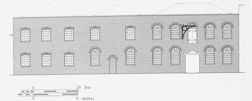
No. 73 Garford Street (former brass foundry and warehouse), south elevation in 1986. Erected 1846–7 for T. Aston, J. Griffiths & Company. Partly demolished
The east end of the site (No. 73A) was taken by Houchin Ltd, electrical and mechanical engineers, in 1927. This firm, electricians for much of the area's public housing, expanded c1940 to take the main building (No. 73) for workshops. The premises were extensively rebuilt in 1946, designated Garford Works, and used, among other things, for the assembly of diesel generating-plant. The three-storey buildings (No. 73A) east of the main range were 1942 and 1950–3 recastings of 1840s blocks with offices and machine shops. (fn. 44)
The triangular plot between this site and the railway line had been filled in the 1850s with a house (No. 75) for George Wright, a rigger and ship-chandler. (fn. 45) The land behind and west of No. 73 was taken by John Kirkaldy & Sons in 1886–7, when the ropeyard had closed, for a paint factory designated the East London Paint Works. Workshops, stores and an office were erected around a yard. This was extended in 1921–2, and used by Kirkaldy & Sons until the late 1950s. (fn. 46) From 1960 until the early 1970s Garford Works (Nos 73–75) and the East London Works were occupied by I. Barget Ltd, furniture manufacturers. The East London Works and No. 75 were subsequently cleared, but the listed Nos 73–73A survived intact until gutted by fire in 1986. The remaining fabric behind the facade was demolished in 1989–90 to clear the way for the Limehouse Link road. (fn. 47)
Garford Street (south side)
The south side of what remains of Garford Street was part of the West India Dock Company's estate when the road was formed. In 1822–3 the dock company enclosed this property behind a boundary wall, except where five cottages (Nos 10–18, even) had been built. The land remained undeveloped, except as allotment gardens, until the 1880s, when the East and West India Dock Company's financial difficulties obliged it to sell such surplus land.
Nos 2–6 (even) Garford Street. The triangular plot east of the junction with Westferry (Bridge) Road was let in 1882 to George Daniel Davis & Company, 'manufacturers of patent improved steam and hand steering apparatus, also windlass and capstan makers'. (fn. 48) Engincering works, with a foundry and workshop 133ft long, were built in 1883 by Parrish & Hawker, of Bow, to plans by Joseph Harris, a Bow architect. (fn. 49) The only surviving fabric from these works is the chimney, which is 56ft high, at the south-east corner of the site. The company acquired the freehold in 1885 and erected a house at the western end of the site in 1888. (fn. 50)
Davis & Company vacated the works in 1901–2. From c1919 to c1926 the buildings were occupied by James Walker & Company, whose main premises were across the road. This tenancy was commemorated by plates fixed below the chimney's stone cap. (fn. 51) The Barget Cabinet Works acquired the freehold in 1936–7 and converted the premises to a furniture factory. (fn. 52) The buildings suffered bomb damage 'beyond repair' in 1940–1 and the site was cleared by 1947. (fn. 53) I. Barget Ltd redeveloped the plot in 1953–4 with three open sheds, designated the Garford Furniture Works, converted to use as a motor garage in the mid-1970s, and vacated in 1989. (fn. 54)
St Peter's Church, Garford Street (demolished)
This church was built to designs by the Ecclesiastical Commissioners' architect, Ewan Christian (1814–95), in 1882–4. As Basil Clarke has noticed, it was very similar to Christian's St Stephen's, Upper Holloway, of a few years earlier. It was perhaps a little old-fashioned for its date (Plate 44b, c).
The church was erected within the parish of All Saints, Poplar, but was officially designated St Peter's, Limehouse. According to the Rector of Poplar in 1887, it was some time before 1864 that he had established a mission called St Mary's, Poplar, at premises on the north side of Garford Street. (fn. 55) In 1864 he had, he said, agreed with the Rector of Limehouse that an adjacent part of the parish of St Anne's, Limehouse, should be attached to its district. Then in May 1864 (according to the Rector of Poplar) the curate of the mission wrote in the Church Times of hopes that any church built for the mission would become 'the nucleus for extending church principles', where a 'Catholic Service' might be found. The secretary of the London Diocesan Home Mission and the Rector of Limehouse took fright and, presumably to limit the sway of these influences, a separate mission, called St Peter's, was established in 1866 by the Bishop of London's Fund in Gill Street, in the part of Limehouse allegedly promised to St Mary's mission. (fn. 56) This latter mission continued in Garford Street in premises seating 200, with (in 1870 and 1871) an organ and a curate sporting a surplice. (fn. 57)
In 1873 an Order in Council provided that the proceeds from the sale of the site of the City church of St Martin Outwich should be devoted to building three new churches, in Dalston, Stepney and Limehouse. (fn. 58) In the summer of 1878, with the first two churches built, the Ecclesiastical Commissioners decided to proceed to build the third with the £8,500 balance from the St Martin Outwich funds. (fn. 59) As the two mission districts of St Mary and St Peter had by then been united (or rather reunited), the search for a site extended over both areas. In 1880 the Commissioners settled on a site on the south side of Garford Street, in Poplar, (fn. 60) but, doubtless to comply with the Order in Council, named the church St Peter's, Limehouse. (fn. 61) This greatly annoyed the Rector of Poplar, who contended that Limehouse parish had done nothing to support his mission in Garford Street. (fn. 1) In fact, as the church was in the Limehouse Hole part of Poplar parish, and was by 1880 somewhat cut off from the rest of Poplar by the West India Dock Road, the West India Docks and the railway, the designation, however inaccurate in terms of the old civil parishes, had some merit in it.
The site in Garford Street was obtained from the East and West India Dock Company. After some haggling the Bishop of London's Fund paid the dock company £1,400 for the chosen site, which was conveyed to it in August 1881 and transferred by the Fund to the Ecclesiastical Commissioners in December 1882. (fn. 63)
In August 1881 the Commissioners asked their architect, Ewan Christian, to design a church to cost £8,500. In December he reported that the ground was so bad that the cost would be much greater than expected. Below the surface he had found 'an average depth of about 16 feet of slush and water', necessitating the use of very expensive coffer-dams to build the foundations. The Bishop of London's Fund was so alarmed that in April 1882 it tried to back out of the purchase. Meanwhile, however, the Commissioners had found reassurance from a man not easily deterred by 'slush'. On hearing of the problem Charles Hampden Wigram, a director of the dock company and member of a family that had 'for some years taken much interest in that Mission District', offered the Commissioners the services, to advise Christian, of the dock company's engineer, Augustus Manning, who took a more sanguine view. Manning's experience with 'heavy warehouse buildings' was that enough concrete piers two yards square could be directly sunk 'through the mud and peat' at a cost not greater than 10s or 12s per cubic yard. The Commissioners, accepting that the foundations would cost £3,000, decided in May 1882 to go ahead. To economize, the accommodation was reduced from 700 to 600 (in fact 580) and the parish room was made integral with the church. (fn. 64)
The foundations were begun, by William Brass of Old Street, in October 1882 (fn. 65) and in January 1883 the tender from B. E. Nightingale of the Albert Embankment was accepted at £4,849 for building the church itself, which was begun in April 1883. (fn. 66) It was completed within Christian's final estimate of £9,704 and consecrated in July 1884. (fn. 67)
As at Christian's St Stephen's, Upper Holloway, his plan gave a wide nave, without clerestory, and a chancel that was not structurally distinct from the nave (fig. 148). A single step led from the nave to the chancel and from the chancel to the sanctuary. There were wide ungalleried north and south aisles, separately roofed, the east end of the south aisle housed the organ and that of the north aisle was walled off, probably as the parish room. A high, narrow narthex gave access from Garford Street. (fn. 68)
The style was a simple Early English. The exterior, closely following the Upper Holloway church, was of stock brick laid in English bond and dressed with stone, under slated roofs. The nearly equal width of nave and aisles gave the three steeply pitched gable-ends that finished the east and west elevations almost equal height. (fn. 69) The aisle windows were plate-traceried, like the others in the church. The nave roof was surmounted by a small bell-turret, probably of wood, which seems to have contained a bell from St Martin Outwich. (fn. 70) A brick gateway in Garford Street contained a wide pointed arch and rose to a central, cross-surmounted gablet.
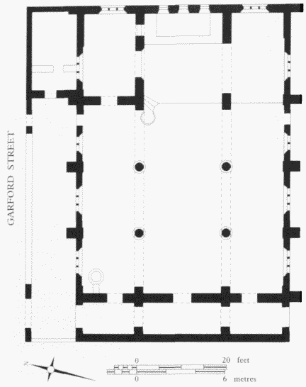
St Peter's Church, Garford Street, plan in 1895. EwanChristian, architect, 1882–4. Demolished
Inside, the same simplicity prevailed, the chief character being given by the wide proportions and the provision of lateral lighting only from the aisles. In this setting the spare decoration of the stone drum of the pulpit and of the octagonal font was sufficient to make an effect. The timber roofs were barrel-vaulted. (fn. 71)
In 1886 an existing organ was rebuilt for the church's use by William Bate & Company of Bow Road, and was therefore perhaps taken from St Mary's mission on the other side of the street, although that was still functioning as a missionary centre a year later. (fn. 72)
In 1885 'Gurney' stoves were installed to heat the church better, Christian emphasizing to the Commissioners how important was 'the thorough heating of Churches in poor districts . . . warmth and light being much valued'. (fn. 73)
It had been intended that a vicarage should be built on the site, (fn. 74) but this was not done and in 1891 the Ecclesiastical Commissioners acquired, for £1,300, one of the biggish houses on the Conant estate at No. 11 Stainsby Road to serve the purpose (see page 202). In 1904 a meeting hall was built, perhaps replaced by the 'church hall' built in 1937 to designs by Milner & Craze. (fn. 75)
Inside the church an iron chancel-screen was introduced in 1909, (fn. 76) but later removed, perhaps in 1960, when the architect Cecil Brown's alterations included bringing forward the 'Holy Table' to form a 'High Altar' in the chancel. (fn. 77)
Repairs had been done under Percy Freyberg, surveyor and estate agent, of Victoria Street, in 1914 (costing £570) and 1919 (£465), and under F. E. Green, architect, of Chelsea, in 1938 (£1,774) and 1952. (fn. 78)
By 1912 special services were being held for the Scandinavian seamen from the adjacent Scandinavian Sailors' Home, in their own languages, (fn. 79) but the high proportion of Chinese in the locality meant that about 1917–19 the church was at 'a low ebb', the Sunday collection yielding on average £1. (fn. 80) By 1930 local conditions were such that when the entrance gate had to be removed 'unspeakable things' were done around the church. (fn. 81)
The church was declared redundant in 1971 and demolished in 1974. (fn. 82)
Mary Jones House, No. 8 Garford Street. Mary Jones House was built in 1981–2 on the site previously occupied by St Peter's. It was erected for the Look Ahead (Beacon Hostels) Housing Association, formed in 1978 through the efforts of Mary Jones, a retired civil servant, to provide accommodation for single people in need. The architects were Christopher Beaver Associates, succeeded by the Prior Manton Tuke Partnership. The main contractor was J. W. Construction Company. The red-brick building is of three storeys and has a reversed-L plan. It accommodates 45 bedsitter flats and a common-room. The lower storey has an impervious flood-protection wall standing forward of the upper-storey walls. Projecting staircase towers along the outer elevations accentuate the relief of the façades. (fn. 83)
Nos 10–18 (even) Garford Street. The West India Dock Company formed its own police force in 1802 and, in 1813–14, built 12 cottages for police constables at Harrow Lane, off the High Street. These proved insufficient to house a growing force, numbering 20 in 1818. John Rennie, the dock company's engineer, submitted plans for two more groups of five constables' houses, consisting of large central houses for superintending constables with flanking semi-detached houses. The building of these on vacant sites in the dock estate at Blackwall and Limehouse was approved in May 1819. Each large house was estimated at £671 10s, the others at £686 10s a pair, or £2,044 10s for each group. They were built by Thomas Johnson & Son and James Broomfield & Company. The Limehouse group, which survives, was completed without extra cost by October 1819. It was designated Colquhoun Place in honour of Patrick Colquhoun, whose Marine Police were the inspiration behind the dock company's private police force. (fn. 84)
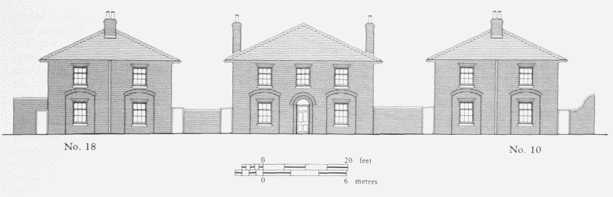
Nos 10–18 (even) Garford Street, south elevation in 1986. John Rennie, architect, 1819
The elevations of these houses are characterized by segmental-headed relieving arches and pyramidal slate roofs with broad eaves (Plate 43b; fig. 149). The central house has a conventional end-stack plan of four rooms with a simple dog-leg staircase. The outer houses originally had two rooms on each floor and single-storey rear sculleries. There were side entrances under blank tympana leading straight to steep and narrow staircases across the width of the dwelling. Originally only the larger house had an internal watercloset.
By the 1830s some of the houses had been given to dock-company employees other than policemen, but they were generally reserved for the police. Privies were replaced with waterclosets in 1853 and electricity was installed in 1930–3. (fn. 85) The PLA sold the houses to Squire & Lodge of Blackheath in 1972, and in 1974–5 works of alteration and renovation ensued, with rear extensions to Nos 16 and 18. The builders were Georgemor's of Walthamstow. The houses were sold off separately and further alterations were made in the 1980s. (fn. 86)
Salvation Army Hostels, No. 20 Garford Street. Set back from Garford Street at the east end of its south side is a men's hostel, originally a Scandinavian Sailors' Temperance Home, but since 1930 administered by the Salvation Army. Riverside House, of 1887–8, is the large building on the south-east part of the site. Grieg House, to the north-east, was built in 1902–3 as an officers' annexe.
The founder and manager of London's Scandinavian Sailors' Temperance Home was Agnes Hedenstrom (1849–1928), a missionary of the Swedish Free Church who had started her work with Scandinavian seamen in 'sailortown' in the late 1870s. From 1880 it was based at Nos 88 and 90 Leman Street, Whitechapel, but the premises soon proved too small and Miss Hedenstrom instituted an appeal to raise £8,000 for a larger building. (fn. 87) The first £1,000 was subscribed by Thomas and Edward Denny, brothers associated with the Leman Street mission. Publicity through an article in Queen magazine helped to raise more money. Trustees were designated and Thomas Denny, Lord Blantyre and David Carnegie formed a building committee. The site in Garford Street was found in January 1887, and the trustees acquired the freehold of the plot, which covered 26,623 sq.ft, from the East and West India Dock Company for £1,200. (fn. 88)
The awkwardly shaped site had a frontage of only 50ft to Garford Street, and so the large hostel was set behind its garden. The architect was Richard Harris Hill, who had designed several mission buildings and was at this date also responsible for a large extension to Dr Barnardo's Homes in Stepney. The builders were Harris & Wardrop of Limehouse. (fn. 89) The Scandinavian Sailors' Temperance Home was opened on 13 February 1888 by Prince Oscar of Sweden and Norway. (fn. 90) The five-storey building had beds for 200 sailors, separate apartments for officers, a large dining-room, baths, lecture-, reading-, writing- and smoking rooms, and a temperance bar. (fn. 91) There were also lavatory blocks, stables and, towards Garford Street, a gatekeeper's lodge, baggage store and boothouse. The buildings cost £9,500 and the total expenditure was £12,000, of which £2,500 had to be raised after the opening. The final donation was made by Sir Donald Currie of the Union Castle Line, in January 1889, on the occasion of Agnes Hedenstrom's marriage to Axel Welin, a civil engineer. (fn. 92)
Riverside House is a stark building, a straightforward and unadorned shelter; only the stuccoed surround to the main entrance gives a hint of 'style'. The commonrooms are all on the ground floor. The spine corridors of the upper floors are supported by substantial moulded cast-iron columns in the dining— and sitting-rooms (fig. 150). The numerous bedrooms are reached from the necessarily spacious open-well staircase in the front hall. The staircase is supported by steel I-beam girders and stringers manufactured by Dorman, Long & Company. The stairs may be made of Stuart's 'Granolithic'. (fn. 93) The gatekeeper's lodge has a surprising flourish, a terracotta cartouche in its inner gable.
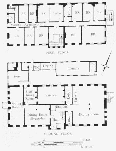
Riverside House, No. 20 Garford Street, schematicground— and first-floor plans in 1935. R. H. Hill, architect,1887–8
To avoid officers having to mix with seamen, an officers' annexe was proposed in 1899. The additional land, extending the site to West India Dock Road, was acquired from the East and West India Dock Company in 1900, with James Carnegie, David's son, donating the purchase price of £2,000. (fn. 94)
Money for the annexe was raised in Scandinavia through the support of the Swedish royal family, and an interest-free government loan of £3,500 was arranged by Prime Minister Bostrom. With such patronage the annexe was destined to be a high-class building. The services of David Barclay Niven and Herbert Hardy Wigglesworth, architects, were secured. (fn. 2) The builders were again Harris & Wardrop. The foundation stone was laid on 6 August 1902 by Count C. Lewenhaupt, the Swedish and Norwegian ambassador to Britain, and the annexe was completed in early 1903, at a cost which was well over the estimate. It comprised 20 small bedrooms, a writing room, a smoking room, and a spacious coffee room, with its own entrance so that it could be used by guests. The other main entrance was positioned to provide ready communication with Riverside House, where all residents dined (fig. 151). A porch may have been added on the east end of Riverside House at this date. A large baggage store was built behind the gatekeeper's lodge. (fn. 96)
Sited as it is near Riverside House and the utilitarian buildings of the West India Docks, Grieg House seems strikingly 'grand manner' with its clock turret, pilasters and festoons (Plate 44a; fig. 151). It is the materials, welllaid brick and slate, and the comfortable proportions, as much as the detail, that distinguish Grieg House from its awkward neighbour. The door surrounds, excepting the keystones, were originally unpainted brick. Despite the attention given to external appearance, the accommodation is far from lavish: there is only one large room, the former coffee room at the north end of the ground floor, which is now a lounge. The upper storeys contain bedrooms off spine corridors.
The Temperance Home was not an unmitigated blessing. The concentration of a large number of foreign sailors was complained of because it attracted prostitutes 'like flies to a honey-pot'. (fn. 97) As well as seamen, the Home housed Scandinavian emigrants, often en route to Australia. By the time that Agnes Welin died in 1928, the Home had become superfluous, so far as its original purpose was concerned, for Scandinavian seamen had largely disappeared from British merchant ships following the Aliens Restrictions Act of 1919. (fn. 98) Its transfer to the Salvation Army was negotiated in 1929. (fn. 99) The buildings were altered, to plans by Alexander Gordon, before the Salvation Army's General Higgins reopened them as the East London Hostel for homeless men on 18 February 1930. (fn. 100) Riverside House had been adapted to accommodate 241 men, some in dormitories, as well as 22 resident staff. There was little space, for a room 22ft 9in. by 17ft contained 12 beds. There were 47 more beds in Grieg House, where the superior accommodation was reserved for the elderly in what became the 'eventide house'. Part of the gatekeeper's lodge was known as the Chinese Room in the 1930s; it may have housed some of the homeless among the local Chinese community. (fn. 101)
The hostel had come increasingly to accommodate elderly people, but following alterations in 1974 to the minimum standards for housing the elderly, alcoholics were housed there instead. A fire at Riverside House in 1981 was followed by proposals to close what was perceived to be outdated accommodation. In fact an extensive programme of improvements was carried out to plans by David Blackwell, Salvation Army Staff Architect, and was completed in 1983 at a cost of £900,000. (fn. 102) The main buildings and the single-storey wash-house outbuilding south of Riverside House were upgraded. The lodge, store and covered yard near the street were converted to form a recreation room, workshops and offices, and former stables along the east boundary wall were demolished. For a short time the buildings housed young people, but they were later used once again as accommodation for alcoholic men.
Grieg House, No. 20 Garford Street, front (west) elevation and ground— and first-floor plans in 1981 D. B. Niven andH.H. Wigglesworth, architects, 1902–3
The Rosher Estate
Much of the area later occupied by the St Vincent Estate and the land on the east side of Westferry Road south of the Docklands Light Railway viaduct was first developed in the early nineteenth century by Jeremiah Rosher, a lime— and timber merchant. In 1801 and 1804 Rosher acquired about three acres in Poplar, together with property in Limehouse that included the lime-kiln near the head of Limekiln Dock, from which he had previously been carrying on business in partnership with Mary Burch. (fn. 103) Rosher owned chalk-pits near Gravesend, one of which was made into a pleasure ground in 1839, and the area is still known as Rosherville. (fn. 104) The three acres were a roughly triangular field, which had been part of the park of the Dusthill, a Limehouse mansion of the sixteenth century or earlier. It lay north of James Mitchell's ropewalk and south of the creek or common sewer that ran into Limekiln Dock, and was empty save for eight back-to-back cottages built just north of the ropewalk by William Syer in 1786. Rosher had Park Street laid out c1809 to run from Limekiln Hill east into the 'park', with the cottages on its south side. They had been joined by other houses at the west end of the street by 1813. (fn. 105)
The surveyor William Robert Laxton can probably be credited with the layout of the Rosher estate from 1811, when Regent Street (later Gill Street) was laid out. He was responsible for the houses on its east side. (fn. 106) Development of the south side of Park Street extended eastwards across the then parish boundary into Poplar with five more houses in 1817–18. Around that date the Royal Sovereign public house was built north-east of the junction of Regent Street and Park Street. (fn. 107) Phoebe Street and Phoebe Court, east of Regent Street, were at least partially built in 1821–2. The east end of Park Street and Park Place, including the Steam Packet public house, were built up in the late 1820s. (fn. 108)
Rosher died in 1848, and the estate was then divided among his three sons, Henry, Edward and George. George surrendered his interest in 1848. Edward died in 1885 and his half of the estate was sold in 1888. Later freeholders, who may have been relatives of the Roshers, included the Rev. John Fleming and members of the Milroy family. (fn. 109)
The estate was made up of terraces of two-storey cottages, generally with frontages of 15ft. Booth's investigators found that the residents were comfortably off, but early in the twentieth century the neighbourhood deteriorated. (fn. 110)
The west end of the south side of Park Street had been redeveloped in the mid-1850s by the demolition of the 1786 cottages and the erection of a cooperage for John Whyte. The corner building (No. 145 Three Colt Street) became the Enterprise beerhouse. (fn. 111) It was rebuilt in 1934 with William Stewart (1867–1940), a public-house specialist, as architect, and Magwin & Company, of Forest Gate, as builders. (fn. 112) The building survives, with stripped and angular neo-Georgian elevations which have attractive details. It was in Limehouse until the parish boundary was adjusted in 1900 to take in the corner site; the boundary markers were replaced on the 1934 building.
The LCC extended Westferry Road north from Garford Street to West India Dock Road through what had been part of the Rosher estate in 1958–60. The work was carried out by Fitzpatrick & Son. (fn. 113) The east side of the road south of the railway viaduct remained vacant until the ILEA built the Limehouse Youth Club there in 1971–2. It was a single-storey, steel-framed, brick structure with a clerestory roof. The adjoining ground was paved as a play area. (fn. 114) The club was demolished in 1991 as part of the Limehouse Link road project.