Survey of London: Volumes 43 and 44, Poplar, Blackwall and Isle of Dogs. Originally published by London County Council, London, 1994.
This free content was digitised by double rekeying. All rights reserved.
'Northern Millwall: Public housing in Northern Millwall', in Survey of London: Volumes 43 and 44, Poplar, Blackwall and Isle of Dogs, (London, 1994) pp. 446-451. British History Online https://www.british-history.ac.uk/survey-london/vols43-4/pp446-451 [accessed 18 April 2024]
In this section
Public Housing in Northern Millwall
The Barkantine Estate
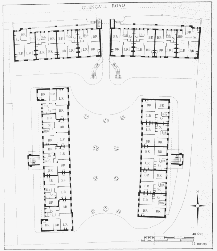
The LCC created the site for the Barkantine Estate in the early 1960s, by the clearance of 60 houses, the compulsory purchase of a further 102 houses (together with other properties and vacant land), and the purchase of a number of plots already acquired by Poplar Borough Council, which had hoped to develop the locality. (fn. 2)
In March 1965 the LCC approved proposals for the development of the site, which covered about 15½ acres. It was bounded by Westferry Road on the west, Alpha Grove on the east, parts of Strafford and Byng Streets on the north, and by Janet Street, Mellish Street and Tiller Road on the south. A tender from J. M. Hills & Sons of Wembley for the construction of 15 housing blocks was accepted in October 1965 by the GLC, which had succeeded the LCC. The estimated cost was £3,092,900. (fn. 3) The first section of the Barkantine Estate was opened in 1968, and the main part of it had been completed by 1970 (Plate 136a ). (fn. 4)
It consists of 634 dwellings in four 21-storey point blocks of 80 flats each (Topmast, Midship, Knighthead and Bowsprit Points); three four-storey blocks of maisonettes at Nos 92–150 (even) Alpha Grove, Nos 1–35 (odd) Cheval Street, and Tideway House; two four-storey blocks of flats and maisonettes (Lantern House and Nos 17–107 The Quarterdeck); three two-storey blocks of flats for elderly people at Nos 2–20 (even) Havannah Street, Nos 2–52 (even) Janet Street, and Nos 6–32 (even) Strafford Street; and three groups of two-storey houses at Nos 12–90 (even) Alpha Grove, with Nos 2 and 4 Malabar Street, and Nos 1–11 (odd) Havannah Street. The four-storey blocks of maisonettes are sited along the road frontages to form a perimeter to the new estate. The density is 137 persons to the acre. There are 12 shops and a public house in an L-plan block, set at right-angles to Westferry Road. In laying out the estate, the opportunity was taken to enlarge and amend the site for the new Isle of Dogs county primary school (Seven Mills Primary School, see page 433). (fn. 5)
In October 1969 the GLC approved the development of the disused site of St Luke's Church, at the east end of Strafford Street, on the south side, as a small addition to the Barkantine Estate. The scheme involved a clubroom for the elderly (the Strafford Friendship Club, intended to serve the whole of the estate), a warden's house, and four old people's dwellings at Nos 42–50 (even) Strafford Street, on the 0.35-acre site. (fn. 6) The Council had difficulty in obtaining a satisfactory tender, and so its own Construction Branch carried out the work in the early 1970s, at an estimated cost of £69,503. (fn. 7)
The final part of the Barkantine Estate to be developed lay between the western parts of Byng and Strafford Streets. In June 1964 the LCC declared this site as the Manilla Street Clearance Area, and adjoining properties were added to create a site of about two acres, for the erection of a six-storey block of 42 maisonettes (Spinnaker House) and a three-storey block of 18 flats (Nos 4–38, even, Byng Street, which includes 12 old people's dwellings). (fn. 8) However, construction did not take place until the mid- to late 1970s, at an estimated cost of £403,350. (fn. 9)
All the design work on the layout of the estate and the individual buildings was carried out by the LCC and GLC Architect's Departments. The blocks throughout the estate are mostly faced in red brick (although the point blocks are clad in yellow flint brick), and have flat roofs. The two-storey houses are arranged in square blocks of four back-to-back, semi-detached dwellings, with individual, walled, gardens.
In the late 1970s the GLC converted the Alpha Grove Methodist Church into a community centre for the Alpha Grove Community Trust, (fn. 10) and improvements were carried out in 1984, with funding from the LDDC. (fn. 11) A health clinic was built between The Quarterdeck and Westferry Road in 1983, and in 1990 the ground surfaces of the estate were given a more decorative appearance, with funding again provided by the LDDC. (fn. 12)
(See below, page 449, for Kedge and Winch Houses, and Nos 1–20 Starboard Way.)
Nos 85–131 (odd) Alpha Grove
In view of the difficulties experienced in acquiring sites for Clara Grant and Gilbertson Houses (see below), Poplar Borough Council decided in January 1947 to purchase all the remaining sites on the east side of Alpha Grove (Nos 85–133, odd). (fn. 13) Plans of the type of house intended for this site were published in the Builder in December 1948, under the names of W. J. Rankin, the Borough Engineer and Surveyor, and C. H. Weed, his Principal Assistant Architect (the latter almost certainly being actually responsible for the design-work). (fn. 14) Economic constraints meant that the Council did not approve a scheme for 24 such houses in Alpha Grove until May 1950, and they were constructed in 1951–2 (Plate 128d ). (fn. 15)
The houses are arranged in three very similar flatroofed, three-storey terraces. The individual frontages are narrow in order to make more economic and higherdensity use of the site. The houses are in mottled red Fletton brick, but the front elevations are mainly rendered with a thin coat of colour-washed pebbledash. Most of the houses have three bedrooms, but a four-bedroomed house is set back at the south end of each terrace. Despite the extra bedroom, these latter houses do not have wider frontages.
St Hubert's House
This block was built by the Isle of Dogs Housing Society (see page 36) on the south side of Janet Street (Plate 125 ). In May 1931 the Society asked if the LCC could assist it in acquiring a site on the Isle of Dogs where it could erect housing for letting at low rentals to the workers in the district. Various sites were discussed, including one in Samuda Street, (fn. 16) but by the beginning of 1933 the Janet Street site had been chosen. Part of it was covered by a derelict factory and the rest was dealt with, in conjunction with the LCC, as a clearance area. (fn. 17) With some adjoining lands, a site of about 1.25 acres was created. (fn. 18)
The derelict factory had been cleared away by April 1934, but further progress was delayed by the need to raise sufficient funds. (fn. 19) The building work was eventually carried out in two phases, and a tender of £14,006 for the erection of the first group of 24 flats had been received from Wheeler Brothers, of Kensington, by February 1935. (fn. 20) The whole scheme was designed by the Society's architect, Ian B. M. Hamilton. (He also acted as architect to the St Pancras Housing Society and to the Bethnal Green and East London Housing Society.) The foundation stone was laid on 29 May 1935 by the Rev. Basil Jellicoe, who had been the inspiration for forming the Isle of Dogs Housing Society, and the first part of the building was officially opened on 20 November 1935 by the Duchess of York (later Queen Elizabeth). (fn. 21) The tenants of Nos 12–34 (even) Janet Street could then be offered accommodation in the new flats, allowing the LCC to implement a clearance order in respect of these houses, to create room for the second phase. (fn. 22) This was completed during 1936 and consisted of 44 flats and a shop. (fn. 23)
When completed, therefore, St Hubert's House provided 68 dwellings. It is a four-storey block in red brick with some stone dressings. The mansard roof is slated and incorporates the top storey. The neo-Georgian style immediately suggests that this might be another LCC development, but what distinguishes it from the Council's flats are the good detailing and the imaginative layout. To the street front the continuous concrete balconies have fluting to the parapet walls. An attractive feature to the rear, garden, elevation is the series of individual castiron balconies leading off windows which are given extra emphasis by the use of stone surrounds. The shop is situated in the side elevation to Cheval Street, and the foundation stone is at the east end of the Janet Street elevation.
It was said of Hamilton that he was 'an architect steeped in ideals of social work as well as architecture', and that he was responsible for innovations in the layout of working-class dwellings, such as the creation of clothesdrying areas and flower gardens. (fn. 24) The zigzag groundplan therefore provides novel forms for the front courtyards (for use as drying areas) and rear communal gardens. In the centre of each courtyard is a concrete drying-post topped by a highly decorative finial with a coloured relief of a stag in the forest (Plate 125c ). These are very similar to the finials on the drying-posts at some of the St Pancras Housing Society estates of the 1930s, and it seems likely that those on the Isle of Dogs are also in Doulton's 'Polychrome Stoneware' and were sculpted by Gilbert Bayes. (fn. 25) The subject of the relief is an allusion to the dramatic conversion of St Hubert, and includes a stag with a crucifix between its antlers. The supposed connections of the Isle of Dogs with royal hunting dogs seem to have been the reason why the flats were named after the patron saint of hunting (see page 378). (fn. 26)
With the help of a loan from the GLC, modernization of the building was carried out in the mid- to late 1970s, under the direction of Max Lock & Company. (fn. 27) The work included the addition of two lift towers to the front elevation and of ancillary buildings at the rear of the block. The lift towers, in particular, deal a severe blow to Hamilton's carefully worked out design.
Clara Grant and Gilbertson Houses
Although Poplar Borough Council received permission to proceed with these blocks in 1946, (fn. 28) acquisition of the necessary sites in Mellish Street proved slow and difficult, so that construction was delayed until late 1948, and the blocks were not completed until about the middle of 1950. (fn. 29) They were almost certainly designed by the Borough's Principal Assistant Architect, C. H. Weed, and the main contractor was G. Hudson & Company of South Woodford, Essex, at a tendered price of £44,329. (fn. 30)
The blocks were named after Clara Grant, who had done such memorable work (especially for poor children) at the Fern Street Settlement in Bow, and John F. Gilbertson, a former long-serving member of the Borough Council. (fn. 31) The two three-storey buildings are almost identical in appearance, and each contains 12 flats. They are faced partly in pinky red brick and partly in yellow flint brick, and have flat roofs. The most striking feature of each block is the cantilevered concrete porch-canopy, resting on bent metal supports, above the main entrance. Refurbishment carried out by Tower Hamlets Borough Council during 1990 included the installation of new kitchens and bathrooms.
Scoulding House
This block, also in Mellish Street, was designed by Burley & Associates of Crouch End for Tower Hamlets Borough Council, and was constructed in 1966–7 by J. & R. Rooff, at an estimated cost of £86,122. (fn. 32) It is named after J. T. ('Tom') Scoulding, a prominent local Trades Union official with the Transport and General Workers Union, who was also a member of the Board of the PLA. (fn. 33) The three-storey block is of load-bearing brickwork, faced in very dark red brick, and has a flat roof. The accommodation consists of nine one-bedroom flats, for elderly couples, on the ground floor, and nine fiveperson, three-bedroom maisonettes above.
John Tucker House
This block, in Mellish Street, replaced Nos 20–60 (even), demolished in a clearance scheme by Tower Hamlets Borough Council during the late 1960s (Plate 137b). It was designed by the Council's architectural group and built in 1976–8 by Whyatt Builders, at an estimated cost of £533,060, including the furnishings. Named after a former Councillor, the three-storey block provides sheltered housing for the elderly. It has 34 one-bedroom flats, including nine on the ground floor for the disabled, as well as a maisonette for a resident warden. At the Councillors' own insistence the roofs are pitched, not flat as originally proposed, although some only have a monopitch. The building is faced in red brick and is divided into four continuous blocks which are set alternately forwards or backwards. The striking metal fence in front was added in about 1987. (fn. 34)
Nos 1–15 (odd) Tiller Road (formerly Nos 318–332, even, Glengall Road)
This is a surviving part of the Glengall Grove Housing Scheme by Poplar Borough Council. In 1925 the Council acquired from the Charteris estate the site of the ropeworks, which occupied the whole of this north side of the road and had been vacant since 1921 (see page 441). (fn. 35) However, the eastern third was leased to the Millwall Engineering Company and, as it was considered too expensive to purchase, this part was not utilized until the lease expired in 1937. (fn. 36) A scheme for 24 houses in three two-storey terraces of eight dwellings each and 40 flats (all two-bedroom) in four four-storey blocks was designed by the Borough Surveyor, Harley Heckford, and built in 1926–7 by R. A. Reader of Hackney. The total cost, including the price of the land, was £42,404. (fn. 37)
The blocks of flats were Georgian in style (Plate 124c ), while the terraces were more eclectic in design: Georgianstyle symmetry and windows, but gablets with applied timber-framing. All the buildings were of yellow brick with red and grey brick dressings. The terraces had hipped roofs covered with tiles, while the flats had slated roofs. The latter had internal common staircases, with a flat arranged either side of the stairs on each floor. (fn. 38)
The other surviving blocks are Hibbert House (fn. 39) (formerly Nos 286–300, even, Glengall Grove), named after George Hibbert, first Chairman of the West India Dock Company, and Alexander House (formerly Nos 206–236, even, Glengall Grove), which is called after Frederick William Alexander, Medical Officer of Health for Poplar between 1892 and 1926. The blocks, which were destroyed during the Second World War, were: Yarrow House (formerly Nos 301–316, even, Glengall Grove), called after Sir Alfred Yarrow, the famous engineer and shipbuilder, who began his career at Blackwall, and which was replaced by the existing terrace of three Orlit Houses, Nos 17–21 (odd) Tiller Road (see below); Maudslay House (formerly Nos 270–284, even, Glengall Grove) — the name deriving from Maudslay, Sons & Field, engineers at Blackwall — which, with a second terrace (Nos 254–68, even, Glengall Grove), was replaced by further Orlit houses, Nos 23 and 25 Tiller Road and Nos 1–6 (consec) Cord Way; and a final terrace, Nos 238–252 (even) Glengall Grove, on a site now occupied by Cressall House.
Cressall House, Tiller Road
This three-storey block of 12 two-bedroom flats was erected in 1950–1 for the Borough Council, and the builders were Thomas & Edge, of Woolwich, at a contract price of £22,136. (fn. 40) It is in mottled red Fletton 'Rustic' brick and has a flat roof. The two front doors are protected by flat cantilevered canopy-porches. The block is named after a former member of the Borough Council, George J. Cressall. (fn. 41)
Hammond House, Tiller Road
This consists of three linked, four-storey, blocks of flats, built in 1937–8 for Poplar Borough Council and designed by Rees J. Williams, the Borough Engineer and Surveyor (Plate 126c ). When the lease held by the Millwall Engineering Company on the eastern third of the rope works site expired in 1937, the Council took possession of the land at a cost of £2,495. (fn. 42) Because of the nature of the subsoil, it was necessary to have piled foundations, supporting a reinforced floor-slab, at a cost of £4,096. (fn. 43) The erection of the superstructures was carried out by direct labour, at an estimated cost of £43,704. (fn. 44)
Several improvements on previous Borough schemes were introduced here, such as separate waterclosets, 11in. hollow external walling on the top floor, and covered buckets for refuse disposal. There were two threebedroom, 24 four-bedroom, and eight five-bedroom flats, plus four five-bedroom maisonettes. (fn. 45) Some larger flats with four or five bedrooms were included to rehouse extra-large families living in overcrowded conditions, (fn. 46) while the maisonettes seem to have been the first to be built by the Borough Council.
The streamlined Modernistic blocks are of red brick, relieved by horizontal concrete bands, and the metalframed casement windows also give a strong horizontal emphasis. The hipped roofs have overhanging eaves and are slated. To Tiller Road, there are paired, individual, concrete balconies with solid parapets. A parapet wall at the centre of each block masks part of the roof and again gives a horizontal emphasis. At the rear, continuous concrete balconies with solid parapets link the three blocks, with access provided by two of the Borough's characteristic International-style, curved staircase-towers, set between the blocks.
Kedge House and Winch House, Tiller Road, and Nos 1–20 Starboard Way
These are all on the south side of Tiller Road. They were planned by the LCC and built by the GLC. In 1963 the LCC agreed to an estimate of £131,000 for the acquisition, clearance, and partial redevelopment of the 1.78-acre site of Stuart's Granolithic Works. (fn. 47) The construction of the ten-storey Kedge House, and the foundation work for the other two blocks, was carried out in 1966–7 by Taylor Woodrow-Anglian, (fn. 48) while the superstructures of the other two blocks were built by the construction branch of the GLC's Housing Department. The development was completed in the later 1960s, at an estimated cost of £376,685 for the whole scheme. (fn. 49) Kedge House is a flat-roofed, ten-storey block, using the Larsen-Nielsen industrialized building-system. It is faced with concrete aggregate panels, and contains 40 one— to four-bedroom flats. The other two blocks are of light brown brick, and have flat roofs. Winch House is a twostorey block of 14 bedsitter and one-bedroom flats. Nos 1–20 (consec) Starboard Way (the short cul-de-sac created for this scheme) is a four-storey block of 20 three— and four-bedroom flats. This block is also in light brown brick, with a flat roof. The three blocks form an outlying part of the Barkantine Estate.
Dunbar House
This group of flats was built by Poplar Borough Council at the east end of the south side of Tiller Road (Plate 126a; fig. 166). It stood where there is now an open space and playground. In October 1930 the Council agreed to purchase the one-acre site, previously a cooperage (see page 445). (fn. 50) Plans for 80 flats, arranged in three blocks, were prepared by the Borough Engineer and Surveyor, Harley Heckford, and work on the new buildings was carried out in 1931–2, by direct labour. (fn. 51) The nature of the site necessitated the use of special reinforced-concrete foundations, and the final overall cost of the scheme, including the land, was £46,375. (fn. 52)
It was decided to call the new development Dunbar House, both to preserve the name long associated with the site and to commemorate the sailing ships of Duncan Dunbar of Poplar, which had sailed from the docks. There were three five-storey blocks: the north, fronting Glengall Grove, contained 40 two-bedroom flats; the east, 20 two-bedroom flats; and the west, 20 three-bedroom flats. The east and the west blocks were set roughly at right-angles behind the northern block. These were the first flats to be built in a Modern style and the first to have balconies with concrete balustrades rather than railings. These balconies ran along the front elevation of the northern block interrupted only by simple brick verticals and a central brick staircase-tower. The main walls were of solid brickwork, with Tondu bricks being used for the external elevations. Less modern touches were provided by the wooden-framed sash windows, which still had glazing bars, and the gabled Welsh-slate roof. The floors, which were supported along the centre line of the building by fabricated-steel members on special foundation-slabs, were of reinforced-concrete and hollowtile construction, covered with asbestic jointless flooring in living-rooms and bedrooms, and granolithic flooring in sculleries, bathrooms and passages. (fn. 53) Many of these floors had to be relaid in 1934 (see page 35). (fn. 54)
All three blocks of Dunbar House were demolished in 1976, and in the early 1980s the site was laid out as an open space, at an estimated cost of £104,300. (fn. 55)
Orlit Housing in Millwall and Cubitt Town
In February 1945 the Borough Council expressed concern about the amount of land required for temporary bungalows and approached the Minister of Health about the need for temporary two-storey terraced houses. In response, the Council was told that, provided sites could be found, 50 or 60 permanent houses would be erected in the Borough as an experiment. (fn. 56) These were of the Orlit prefabricated type, employing precast concrete and using the pier-and-panel system (see below). They were manufactured by Orlit Ltd of Buckingham Gate, a firm founded in 1940, according to Marian Bowley, 'as a subsidiary to a modest building firm with an eye to the future'. (fn. 57) In fact the Borough Council had already, in August 1944, identified the first three sites considered suitable for housing redevelopment as soon as a post-war rebuilding programme might begin. One was outside the parish, but the other two were on the Isle of Dogs — the Kingfield Street Estate Area and the Glengall Grove Area. (fn. 58) Both had suffered considerable bomb damage and represented partial replacement and extension of existing Council developments. Additional properties were purchased, and in May 1945 it was decided that these two areas could provide the requisite number of sites for the Orlit housing. (fn. 59)
By September 1945 the sites had been cleared by German prisoners of war, and the Ministry of Works, on behalf of the Borough Council, had begun to erect the buildings. (fn. 60) Two months later, the frame for the first pair of houses in Billson Street had been erected. (fn. 61) In January 1946 Mrs Eleanor Roosevelt, who was in London to attend a United Nations Organization Conference, paid a visit to Poplar, during which she inspected the Orlits. (fn. 62) A month later the first pair of houses in Billson Street was officially opened, very appropriately by Alderman C. W. Key, MP for Bow and Bromley, and at the time Parliamentary Secretary to the Ministry of Health. (fn. 63) All 23 of the Orlit houses on the Glengall Grove site had been completed by the end of 1946. (fn. 64) Their present addresses are Nos 162–172 (even) and 133–137 (odd) Alpha Grove, Nos 1–6 (consec) Cord Way (Plate 128c), Nos 31–35 (odd) Mellish Street, and Nos 23 and 25 Tiller Road. They are mostly arranged in terraces of three or six houses, but there is one semi-detached pair. The last of the 28 Orlits on the Kingfield Street Estate was not completed until 1947. (fn. 65) This group consists of Nos 6–16 (even), 28, 30, 5–27 (odd) Billson Street and Nos 10–24 (even) Parsonage Street; they are arranged in semi-detached pairs.
Dunbar House, Tiller Road, ground-floor and site plan as built. Poplar Borough Council,Harley Heckford, Borough Engineer and Surveyor, 1931–2
The design for a three-storey block of 12 flats on a site in Mellish Street had been agreed in December 1945, but construction was delayed, mainly because not enough components were available (fig. 167). In addition, Orlits were normally of two storeys, and these three-storey flats were very much an experiment. (fn. 66) Indeed, according to the Architects' Journal, this was the first block of precastconcrete-framed flats to be built in this country. (fn. 67) Design work was carried out, in conjunction with the Ministry of Works, by the Borough Engineer and Surveyor's Department, initially under S. A. Findlay, and then, from January 1947, his successor as head of the department, William J. Rankin. (fn. 68) Amendments to the scheme were still being made as late as March 1947. (fn. 69) The Borough's own direct labour force was erecting a further 60 Orlit houses on the Abbott Road Area, just outside the parish, and, with this experience, they were able to tender successfully for the construction of the flats in Mellish Street. (fn. 70) So, by a peculiarly elliptical arrangement, the Borough's direct labour force found itself acting as contractors to the Ministry of Works, which in turn was building the flats on behalf of the Borough Council.
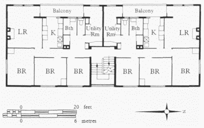
Rawalpindi House, Mellish Street, first-floor plan asbuilt. Poplar Borough Council, W. J. Rankin, Borough Engineerand Surveyor, 1947–8
Work on site commenced on 4 July 1947; (fn. 71) erection of the frame started on 10 September; and the third storey was completed in 36 working days, including Saturday mornings. As the third storey was being built, the firstand second-floor units were laid and completed within three weeks. These floors then provided working platforms for the men building the walls. Such an arrangement also provided cover, so that work could continue by electric light during the dark winter days, and even in bad weather. (fn. 72) Charles Key, now Minister of Works, paid an official visit to the flats on 10 March 1948, and officially handed over the keys to the Borough Council ten days later. (fn. 73) The flats attracted notice in the national and technical press, as well as being featured on BBC radio. (fn. 74) By May 1948 all the flats had been handed over for letting. (fn. 75) The block is named after the Armed Merchant Ship Rawalpindi, sunk by German warships on 23 November 1939. Before the war the ship had often been in the King George V Dock, when on the Bombay and Japan service. (fn. 76)
Orlits consist of a structural precast-concrete frame, clad in small precast reinforced-concrete panels, and with a flat roof. For houses, two-storey precast-concrete portal frames span transversely from front to back to support the secondary floor and roof beams. These portal frames consist of cast column or pier units, bolted together using end-capping plates, with in-situ cast joints (or 'stitches') connecting precast-beam components. The external walls are of cavity construction, using two leaves of 2½ in.thick concrete blocks, tied together with galvanized metal ties, and with the main portal frames not tied to the external wall but simply positioned within the cavity. (fn. 77) The block of flats is generally similar in construction, but the system was adapted to provide an extra storey. (fn. 78) One of the advantages of such a pier-and-panel type of building was that the site work was largely a matter of fitting together ready-made components. This simplification, and the lightness of the components, made the system particularly useful when houses were required only in relatively small numbers, as was the case in Poplar. Although Orlit Ltd was the sixth largest producer of non-traditional houses in England and Wales in 1945–55, the firm was not a major manufacturer of such houses, and only accounted for 4.3 per cent of the national output during this period. (fn. 79)
As was usual with Orlit dwellings, both houses and flats have a living-room, kitchen, three bedrooms, bathroom and w.c. The first- and second-floor flats also had a utility room, with a recessed sun-balcony leading off it. (fn. 80) Cookers and wash-boilers were provided as part of the equipment of each dwelling, and a higher rent was paid because of this. (fn. 81)
It was not until 1951 that the Borough Council finally agreed terms for the purchase of the 54 Orlit houses and flats on the Isle of Dogs. The total price for the houses was £60,000 and for the flats £60,000, making the latter, in comparison, an expensive experiment. In addition, remedial works were already needed, estimated to cost a further £8,000. (fn. 82)
In 1982 and 1983 there was Government concern about the possibility of failure of some of the structural joints in certain Orlit dwellings, but, following a sample investigation throughout Britain, the Building Research Station concluded that 'the majority of Orlit houses are likely to be found in good structural condition'. (fn. 83) In 1988 Tower Hamlets Borough Council received a report from consultants on the condition of two Orlit houses, Nos 25 and 27 Billson Street. This suggested that, in view of the high chloride levels in all the concrete components, this pair of dwellings was not economically repairable, and the Council decided to replace them with two new four-bedroom houses. On the other hand, refurbishment work was carried out on Rawalpindi House during 1990, (fn. 84) and included the installation of entryphones, the construction of new heavy wooden front porches and the creation of enclosed front areas.