Survey of London: Volumes 43 and 44, Poplar, Blackwall and Isle of Dogs. Originally published by London County Council, London, 1994.
This free content was digitised by double rekeying. All rights reserved.
'Southern Millwall: The Mellish Estate in Southern Millwall', in Survey of London: Volumes 43 and 44, Poplar, Blackwall and Isle of Dogs, (London, 1994) pp. 480-489. British History Online https://www.british-history.ac.uk/survey-london/vols43-4/pp480-489 [accessed 18 April 2024]
In this section
The Mellish Estate in Southern Millwall
The Harbinger Road Area
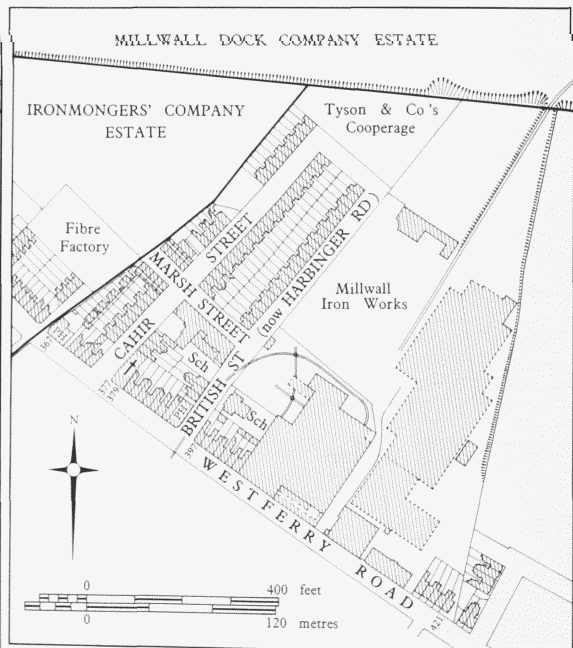
In 1817 the area now largely covered by Cahir Street, Harbinger Road (British Street until 1929) and Hesperus Crescent was three meadows and a patch of swamp (fig. 183). It was bought by William Mellish in 1820, but, although it had a good frontage to Westferry Road, there was no development on it until the late 1830s, when the Glengall Arms public house (No. 367 Westferry Road) was built by Henry Bradshaw, a local grazier. Over the next few years Bradshaw added some very small cottages at the back of the public house, built terraced houses along the main road and the new Cahir Street, and more cottages along Marsh Street. All this was done on a single 63-year building lease. (fn. 1)
It was not until the mid-1850s that house plots were sold in any number, and even then only a handful of houses and another public house (the Great Eastern, No. 395 Westferry Road) appeared. The lessees of these later houses included a ship steward and a builder, both from Seven Sisters Road, North London, a shipbuilder, a cooper and a cement maker, all living locally. (fn. 2) They were typical mid-nineteenth-century Millwall houses, with narrow, round-arched doorways, first-floor windows set in recessed arcading, and corniced parapets.
Harbinger Road area. Based on the Ordnance Survey of 1893–5 and 1938
A large area, with a frontage of 300ft to Westferry Road, was let to the shipbuilder John Scott Russell (fn. 3) and became part of the Millwall Iron Works empire; further ground was taken for the building of the Millwall Docks. House building here had stagnated long before the economic depression of the late 1860s, and some ground was vacant for decades.
Tyson & Company's cooperage was established about 1895. The main building was a corrugated-iron shed. Part of the yard was let in the early 1930s for storing barrels of rosin from Winkley's Wharf, while the rest was used by H. Burgoine & Sons, haulage contractors, mostly as a dump for old lorries. Soon afterwards Tysons moved to part of the old Millwall Iron Works and Burgoines took over the former cooperage. It was later a steelyard and engineering works. (fn. 4)
Nos 7–53 (odd) Harbinger Road, and Nos 16–54 (even) and 39–59 (odd) Cahir Street were built in 1902–4 on new extensions to those streets. They are plain twostorey houses of four rooms and a scullery, markedly different from the fancy, bow-windowed houses built in Mellish Street at about the same time (Plate 84b). The joint lessees were William Wells of Rotherhithe, cartage contractor, and Thomas Benton of Camberwell, contractor. The builder was E. J. Orpin of Anerley. (fn. 5)
The Glengall Arms was bought in 1925 by the London Diocesan Fund for use as a priest's lodging and clubhouse in connection with St Cuthbert's Church. It was acquired by the LCC in 1932 and demolished, together with nearby houses, for public housing developments. The remaining houses in Westferry Road were mostly pulled down in the 1930s or bombed in the Second World War, and by the mid-1960s none of them was left. (fn. 6)
Millwall British School (demolished)
Already by the 1840s the 'very peculiar' nature of the Isle of Dogs — cut off from the rest of Poplar by the docks — was having an effect on the provision of education. Millwall British School was the first school in the Isle of Dogs, serving a population estimated at 'upwards of 2000'. (fn. 7)
Largely financed by private subscription, with a topup grant from the Committee of Council on Education, the school was founded by local businessmen and built in 1846–7 at a cost of £850, including fittings, on a site donated by the Countess of Glengall. It was designed by William Wallen, junior, of Greenwich, and built by James & Jonathan Coleman of Bermondsey. Brick-built, of two storeys, with an asphalted concrete ground floor and a pitched slated roof, it comprised two rectangular schoolrooms and narrow lean-to wings for stairs and ancillary rooms, giving an overall T-shaped plan. The school was run on the principles of the British and Foreign School Society by a committee of managers, mainly drawn from the local business community, until 1871, when it was transferred to the School Board for London. Before the transfer the school roll comprised about 130 boys and 140 girls. Apart from inadequate toilets and the constant noise from the Millwall Iron Works, the building offered a reasonable teaching environment. But there were only two teachers, and in the lower classes only two of the three Rs were studied (this was a result of local poverty: each subject studied required separate payment). (fn. 8)
Closed in 1873, on the opening of new premises on the opposite side of the road, it was apparently used for a time as a chapel called Millwall Tabernacle, but was bought by the School Board in 1886 and subsequently used for cookery classes. Reconditioned for ordinary teaching use in 1932, the building was badly damaged by bombing during the Second World War, and after the war the site became a scrapyard. (fn. 9)
Harbinger School
A school for 240 each of boys, girls and infants was projected by the School Board for London in 1872, to replace the former Millwall British School. A limited competition for designs was won by the influential architectural teacher Richard Phene Spiers (1838–1916), Master of Architecture at the Royal Academy Schools. The regularly shaped site, with frontages to three streets, gave Spiers the opportunity to formulate what might have become a standard school plan. The design he produced, while not the most distinguished of the early London Board schools, was fully in accord with the main principles of school design advocated by the architect to the Board, E. R. Robson (fig. 184). (fn. 10)
A three-decker, it followed the usual system of placing infants on the ground floor, girls on the first floor, and boys on the top. (fn. 11) The plan was T-shaped, with a wide north-lit street frontage along which were ranged the main teaching rooms, and a central rear wing comprising the staircases, most of the ancillary accommodation, and a drawing classroom.
The plan adopted followed Robson's view that the girls' and infants' entrances should be close together, that for the boys 'as far away as possible', preferably in another street. Schoolroom and classroom provision was the usual School Board compromise between the 'Prussian' system of one class to one room, with a hall for examinations, and the demands of the English pupil-teacher system. There was a schoolroom on each floor, with pairs of classrooms across the ends. These 'double classrooms' were for certificated teacher and pupil-teacher respectively, and were divided from each other by a partition with a glazed sliding door, enabling the senior teacher to keep an eye on the other class. The drawback was that, although both rooms could be side-lit, only one could satisfactorily be lit from the left if both were to face the same way. A further disadvantage, stemming from the grouping of the staircases, was that access to and from the classrooms was through the schoolroom.
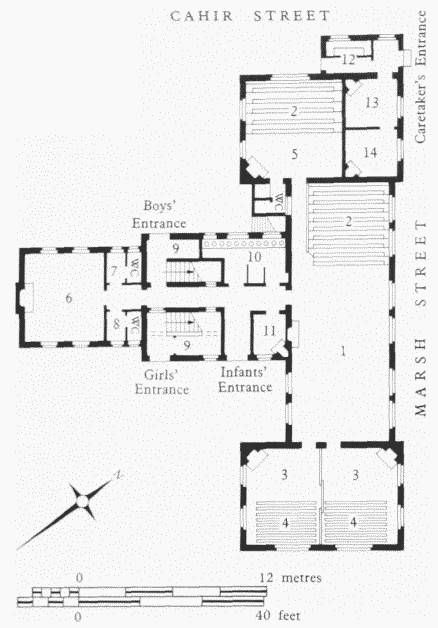
Harbinger School, Cahir Street, ground-floor plan as built. R. P. Spiers, architect, 1873Key: 1. Infants' School: 2 Gallery: 3 Classroom: 4 Benchesand Desks: 5 Babies' Room: 6 Manager's Room: 7 Masters' Cloakroom: 8 Mistresses' Cloakroom: 9 BroomCupboard: 10 Infants' Cloakroom: 11 Infants' Mistress's Cloakroom: 12 Larder: 13 Living Room: 14 Bedroom
The infants' department included two 'galleries' of tiered seating, one for the very youngest children in their own room, and one in the main schoolroom. A large room on the ground floor of the rear wing, under the art room, was provided for meetings of the school managers. (fn. 12)
The school was built by W. H. & J. Mansbridge in 1873. It was completed largely as Spiers had conceived it, but with the addition of a wing on the south-east side to accommodate more infants. The total cost of the school was £9,570, of which £1,150 went on the purchase of the site, £6,070 on building and £700 on fittings. (fn. 13)
Extensive changes were made in 1906–11, including partial demolition as well as additions, which destroyed much of the original layout and gave the school a Ushaped plan. A separate schoolkeeper's house was built in 1909, and several nearby houses were acquired to allow for the enlargement of the playground. (fn. 14)
After the abolition of the London School Board, the school was known as British Street Council School, and from 1930 as Harbinger LCC School. It is now known as Harbinger School.
St Cuthbert's Church (demolished)
A mission church within the parish of Christ Church, St Cuthbert's was built in 1897 (although the site was acquired in 1893 and tenders sought as early as 1894). The site, formerly occupied by two houses — Nos 377 and 379 Westferry Road — was given by Lady Margaret Charteris, who laid the foundation stone on 15 October 1897. The first minister, the Rev. Richard Free, later described the unwelcoming attitude of the local people to his efforts to introduce them to a rather 'High' (and 'high-profile') churchmanship. (fn. 15)
Designed by J. E. K. and J. P. Cutts in the quasidomestic Tudor style much favoured in the 1890s, St Cuthbert's was built by J. H. Johnson of Limehouse (Plate 82c). Of red English-bond brickwork with stone dressings, it comprised ground-floor club-rooms and a first-floor church with a lofty arch-braced collar roof. An organ-gallery was added in 1900. St Cuthbert's was virtually destroyed by a bomb in September 1940. (fn. 16)
The Chapel House Street Area
The district south-east of the Land of Promise, bounded on the east by East Ferry Road and Ferry Street, is generally regarded as the southernmost part of Millwall, although there probably never were any windmills so far south (fig. 185). In 1817 the land, owned by William Mellish, consisted largely of two meadows of about ten acres each, one of which had been bisected by Westferry Road, and a riverside timber-storage pond. In 1821 Mellish bought the adjacent Ferry Piece, where a cluster of industrial and other buildings had grown up since the seventeenth century. (fn. 17)
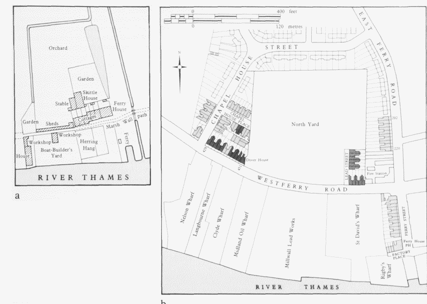
Chapel House Street area a The Ferry Piece and Orchard in 1810 b Plan based on the Ordnance Survey of 1894–6, revised 1938. Shading indicates houses demolished by 1938
Industrialization here took a leap forwards in the early 1820s with the leasing of a site at the northern end of the ground to the Imperial Gas Light & Coke Company as an extension to their chemical works. A scheme by the Imperial Plate Glass Company to set up a glassworks to the south of this proved abortive, though a drawing of the proposed works, designed by John Mullins, was exhibited in 1826. (fn. 18) By the mid-1840s, the intended glassworks site was held by a naphtha distiller, William Jegon, who sublet various portions, in so doing creating the main road-to-river sites which remained distinct entities throughout most of the industrial history of the area.
Industry at the Ferry Piece c1700–c1850
The Ferry Piece comprised about an acre of marsh and orchard, together with part of the marsh wall and the ferry landing itself. The date of the earliest industrial development near Potter's Ferry is not known for certain, but by the beginning of the eighteenth century there was a building near the ferry called the Starch House. This was probably a starch factory rather than a place for starching linen: although there was a steam laundry near the ferry in the early nineteenth century, and later a proposal for a laundry for Greenwich Hospital to be set up nearby, these appear to have been coincidental. Simon Lemon, who owned land near the ferry in the early eighteenth century, was himself a starch-maker and haberdasher. Very likely the Starch House had some connection with the flour-milling trade which grew up on the Isle of Dogs from the late seventeenth century.
The main requirements for starch-making would have been a plentiful supply of clean water and an area of open ground, together with a wooden shed. Starch in the eighteenth century was generally prepared from refuse wheat. The whole grains were steeped in vats of water, left in the sun to hasten fermentation, and, when sufficiently soft, put into canvas bags and beaten out over a plank laid across the top of a receiving vessel, leaving the husks behind. The flour paste was further steeped in water until a thick sediment of starch was obtained, which was left in the sun to dry. (fn. 19)
Samuel Hart was the occupier of the Starch House for more than 30 years until its closure about 1740, and may have been part of the company which ran the works in 1705. The Starch House was thereafter renamed (or rebuilt as) the Ferry House, occupied by W. Hart and probably used as a place of refreshment and shelter for ferry passengers until the building of the present Ferry House public house. (fn. 20)
After the closure of the Starch House there was little or no industrial or craft activity at the Ferry until the early nineteenth century, when a boat-building yard and a herring-curing works were set up on the Ferry Piece, the latter by two Lower Thames Street fishmongers, Messrs Fortune & Everth. (fn. 21)
John Fugman, a Spitalfields emery-paper maker, appears to have moved his business to the Isle of Dogs about 1813, later going into partnership with James Hilton to manufacture colours at the former fish works. The premises comprised a group of buildings, which probably included the former curing sheds. James Hilton & Company, as the firm became, lasted until the mid-1820s. In the second quarter of the nineteenth century a steam laundry was set up here, and later there was some enterprise in connection with two industries which attracted the attention of numerous entrepreneurs in the late 1830s and 1840s: wood paving and asphalt. The founding of Millwall Pottery, however, marked the beginning of the first long-term industrial activity on the site. (fn. 22)
Potter's Ferry and the Greenwich Vehicular Steam Ferry
Although a ferry at Greenwich existed by 1330, and probably much earlier, the first specific record of a ferry between Greenwich and the Isle of Dogs occurs in a will of 1450. (fn. 23) Plying to and from the manor of Pomfret (see page 375), this was almost certainly the ferry 'for men horses beasts and all other cattle' that came to be known as Popeler Ferry and eventually Potter's Ferry. Popeler Ferry was granted, along with land in Hackney and Stepney (including the manor of Pomfret), to Thomas, Lord Wentworth by Edward VI in 1550.
Greenwich Vehicular Steam Ferry. From an engraving in Engineering, 17 February 1888
The name Potter's Ferry, of uncertain origin, is first mentioned in a lease of 1626 to Nowell Warner of Greenwich. (fn. 24)
The Warners — Masters of the Royal Barges under successive monarchs from Elizabeth I to William III — were connected with Potter's Ferry for nearly 150 years. Nowell's son John bought the ferry outright in 1676, and his family continued to hold the rights to it until 1762, when Richard Warner sold it for 15 guineas to a group of Greenwich watermen, later known as the Potter's Ferry Society. (fn. 25)
During the late eighteenth century the ferrying of horses and cattle appears to have been discontinued, footpassengers only being conveyed, but with the opening of the West India Docks the need for a regular horse-ferry revived. In the early nineteenth century a rival ferry service was set up by the Poplar and Greenwich Ferry Roads Company, both operators sharing the old landingplace, though not harmoniously. The Potter's Ferry Society twice destroyed the company's toll-gates-claiming that prospective passengers were using the Deptford Ferry in preference to Potter's Ferry, to avoid having to pay the road toll — and the two bodies were involved in much litigation. During the 1840s the horse-ferry was discontinued, and in 1868 the company assigned its rights in the ferry to the society. In 1878 the society sold out to private operators and was itself subsequently dissolved. (fn. 26)
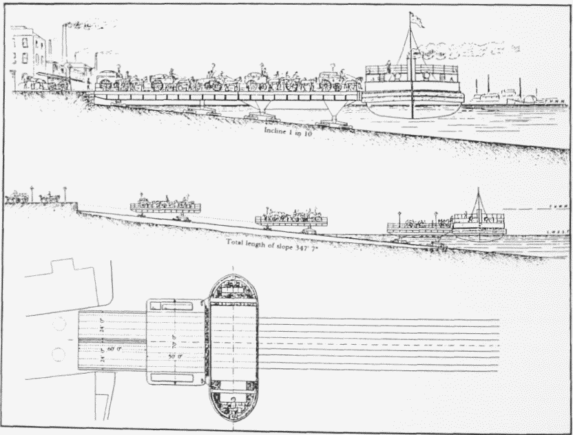
The lack of a vehicular ferry prompted the Metropolitan Board of Works to plan a free steam-ferry in 1884–5, but the project collapsed in the face of heavy compensation claims. It was left to private enterprise to meet the need. The Greenwich Ferry Company, incorporated by Act of Parliament, bought the rights to the ferry for £80,000, and in February 1888 the first crossing of the Greenwich Vehicular Steam Ferry was made. (fn. 27)
There were two steel-hulled ferry-boats, identical at each end to enable them to shuttle back and forth without turning. Designed by George Skelton and built by Steward & Latham at Britannia Yard in Millwall, they were each 120ft by 40ft with a 6ft draught. Trimming was achieved by pumping water in or out of tanks in either side of the hull. There were other refinements to facilitate docking. Elmwood fenders of 12in. by 3in. section, fixed along the sides of the hull in three rows of three with 1½in. spacers between the bars in each row, provided a continuous spring buffer to cushion the impact with the landing platforms. The bulwarks along the sides were arranged as a series of hinged panels — operated, with the assistance of counterweights, by winding-chains attached via sheaves to steam cylinders — which were lowered to form a complete connection between boat and landing-stage. The decks, of asphalted steel plates laid down on a timber base, were fitted with four sets of 4ft 8½in.-gauge railway lines. (fn. 28)
Traffic boarded in two stages, from the street to either one of a pair of parallel traveller-platforms and thence to a movable landing-stage alongside the ferry-boat. The platforms, 60ft long by 23ft wide, and the 70ft by 60ft wide landing-stages, were mounted on bogies running on rails set on 348ft-long concrete ramps following the river bed at an incline of one in ten (fig. 186). (fn. 29)
The platforms and landing-stages were constructed of mild-steel plate with wooden decking laid with rails to correspond to those on the boats. They were hauled or checked by steel cables from shore-mounted windingengines, with the aid of counterweights hanging in castiron-lined shafts 145ft deep (with 'fine old English crusted conservatism' the shafts were sunk using divers). The working plant, designed by Standfield & Clark of Westminster, was made by Appleby Brothers of East Greenwich, who also built the ferry-boat engines. (fn. 30)
A technical success but a financial failure, the ferry was forced to close, temporarily in May 1890 and permanently in 1892. (fn. 31) The concrete slipways on both sides of the river can still be seen at low tide.
For the later history of the site, see page 515.
The Ferry House Public House
The name Ferry House was in use from 1740, and it is likely that the first Ferry House was merely the old Starch House renamed and to some extent converted as a tavern. The premises were probably rebuilt or largely rebuilt in 1748 9 on or near the old site, when a 55-year lease of the Ferry Piece, at progressive rents, was granted to William Brown, a Greenwich victualler. The core of the building is thought to date from that time. Its present appearance is the result of successive changes of varying degree. Alterations and improvements were carried out throughout the nineteenth century. Externally, the building today is substantially as it was in the late nineteenth century, but it has lost some features, including an ornamental balustrade to the roof garden. (fn. 32)
Nelson Wharf, No. 302 Westferry Road
The westernmost of the nineteenth-century riverside sites in this area was occupied in the mid-1840s by Ernest Jametel & Company, borax manufacturers, and thereafter by Sir William Burnett & Company as Nelson Wharf. (fn. 33)
Sir William Burnett (1779–1861) was a naval surgeon who distinguished himself at Trafalgar and other battles, rising to become Inspector of Hospitals to the Mediterranean fleet and, in 1822, one of two Medical Commissioners to the Navy Victualling Board. From 1831 until his retirement in 1855 he was the head of the Medical Department of the Navy, being designated Director-General in 1844. (fn. 34)
In about 1836 Burnett devised an anti-rot and mothproofing treatment for timber, cordage, canvas and other cloths, using an aqueous solution of chloride of zinc. A stronger solution was produced for disinfecting and deodorizing, and in 1838, much to the scandal of the medical profession, Burnett patented both inventions and proceeded to exploit them commercially. 'Burnettizing' became a standard wood-preservative technique, having several advantages over creosoting. The fluid was colourless and odourless, hardened the wood and made it less flammable, and it did not prevent painting or varnishing. (fn. 35)
The disinfectant, sold as concentrate, was used in hospitals until superseded, first by lead-nitrate solution and eventually potassium permanganate: the use of zinc chloride solution was, however, revived during the First World War when permanganate was in short supply. It was also used for preserving anatomical specimens. (fn. 36)
The buildings at Nelson Wharf were mostly brickand-corrugated-iron sheds and workshops, erected at various times. By the early twentieth century they were predominantly old and dilapidated, but in 1906–8 and 1914 new sawmills were built. For many years part of the premises was occupied separately by a succession of firms. They included timber merchants and shipwrights in the 1860s, Homan & Rodgers, girder manufacturers, in the 1870s, the Liepmann Carbon Company Ltd, manufacturers of electric-lamp components, battery plates and carbon roads, in the 1880s, iron-founders and horseshoe manufacturers in the 1890s, and soft-metal refiners in the 1920s. (fn. 37)
Timber preserving (both by Burnettizing and creosoting) and timber merchanting were the principal activities at Nelson Wharf in the mid-1890s, though disinfectant (latterly of carbolic acid rather than zinc chloride) continued to be made there in the 1920s. Soldering fluid was also produced. By the 1930s the business was exclusively concerned with timber. (fn. 38)
In the late 1970s Sir William Burnett & Company Ltd, timber and plywood importers, moved to Cuffley, Hertfordshire. In 1994 the wharf is still awaiting redevelopment.
Langbourne Wharf, No. 304 Westferry Road
This, like the sites on either side, was for many years a chemical works. The name appears to have been adopted in the mid-1870s when the works were taken over by Couper McCarnie & Company, sal-ammoniac manufacturers. By the mid-1880s most of the site had been covered by a number of brick-built sheds, variously roofed with tiles or corrugated iron. Later occupiers of the wharf included the London Wire Netting Company Ltd, galvanizers and wire-netting makers, in the 1890s; Duggan, Neel & McColm Ltd, paint and distemper manufacturers, in the years preceding the First World War; motor-car shippers and waste-paper merchants in the 1920s. It was amalgamated with Matthew T. Shaw & Company's Clyde Wharf about 1930. In 1969 the name Langbourne was given to a new range of steel-hulled river and canal cruisers developed by Shaws. (fn. 39)
Clyde Wharf, No. 306 Westferry Road
The site was leased by William Jegon in 1845 to Alexander Denoon, a merchant, who set up a chemical works there. The name Clyde Wharf dates from about 1866, when the premises became William McArthur & Company's ship-breaking yard. In 1881 it was acquired by Matthew T. Shaw & Company, engineers and iron-founders, who covered most of the site with an iron-roofed shed with travelling-cranes and rails for trucks. The company was established in 1850 and had been based at Westminster Bridge Wharf in Lambeth. It specialized in constructional iron- and steel-work, manufacturing girders and joists, iron doors and roofing, fireproof floors, and tanks. The site was renamed 'The London Constructional Iron and Bridge Works', but the old name persisted. Later, with the expansion of the works on the north side of Westferry Road, Clyde Wharf was known as 'South Yard'. In 1994 the site is vacant. (fn. 40)
Millwall Lead Works, No. 308 Westferry Road
Immediately south of Clyde Wharf was the Millwall Lead Works, set up by Edmund and William Pontifex of the firm Pontifex & Wood in about 1843. Pontifex & Wood was founded in 1788 and based for many years in Shoe Lane, Fleet Street, developing a large business as engineers, millwrights and manufacturers, specializing in equipment for brewing, distilling, dyeing, sugar-refining and other industrial processes. The Millwall works embraced a wide range of metallurgical and chemical activities, including dye, colour, paint and varnish making, the manufacture of white lead, copper sulphate, citric, tartaric and sulphuric acids, and the smelting and refining of silver, copper and antimony. White lead, used principally in paint manufacture, became the principal product. (fn. 41)
Pontifex & Wood Ltd was wound up in 1888 and the business was acquired by the newly incorporated Millwall Lead Company Ltd. The works were taken over by Locke, Lancaster & W. W. Johnson & Sons Ltd a few years later. Parts of the works were later occupied by other independent or associated companies, including the London Lead Smelting Company Ltd, Henry Grace & Company Ltd, white lead manufacturers, and the Millwall Chemical Company Ltd, set up to extract distillates from sawdust and other wood waste. (fn. 42)
The northern end of the site was occupied from the early 1890s until about 1910 by the Millwall Oil Company Ltd and its successors. It became known as Millwall Oil Wharf (No. 308A Westferry Road), but was later taken back into the lead works. (fn. 43)
By the 1950s Associated Lead Manufacturers occupied the whole area from the south side of Clyde Wharf to the Ferry House, with the exception of Rigby's Wharf but including the sites of mid-Victorian terrace houses on the west side of Ferry Street. The ground was densely built over with lead rolling and wire-drawing mills, furnace houses and refining shops, a large shop for the production of lead monoxide (litharge), and various ancillary buildings. The only substantial remnant of the nineteenth-century works was the original furnace chimney-shaft which, at about 240ft high, is thought to have been the tallest ever erected on the Isle of Dogs. A large three-storey block containing office, laboratory, catering and staff-welfare accommodation was built around 1946. A conventional flat-roofed structure of brick and reinforced-concrete, with a central courtyard, it was one of relatively few such buildings on a large scale to be erected on the Isle of Dogs. The architects were Keith Murray & C. S. White. Along with the remaining disused lead works buildings, it was pulled down in 1986–7. Before closure, the works, which once produced such goods as tinned lead-foil for lining tea-chests and casings for X-ray equipment, were occupied by Associated Lead's Paint Division. In 1994 the site is vacant. (fn. 44)
Millwall Pottery
This was set up in 1852–3 by Thomas Wilcox, Edward Price Smith and Orlando Webb, earthenware manufacturers. The trading name changed over the years, from Wilcox, Barnard & Pryce, to Wilcox, Pryce & Company, then Thomas Wilcox & Company and later Edward Wilcox & Company. The name Millwall Pottery does not seem to have been adopted until the early 1870s, when the works were occupied by Wilcox's successors, Henderson Hewitt. They were followed by Thomas James Allen in the late 1870s, but Wilcox was still in the background and in 1881 he formed Millwall Pottery Ltd to take over the works. At that time the premises, entered by a narrow way just north of the Ferry House, comprised a yard with a range of single-storey buildings. These were only partly purpose-built, incorporating a couple of old warehouses, together with three cottages, which, when the pottery was started, had been occupied in recent years by the Bastenne Gaujac Bitumen Company and Robert Carey, wood pavement manufacturer. (fn. 45)
The pottery, which produced a range of general and sanitary earthenware, closed in the late 1880s. It was thereafter occupied briefly by the J. R. Alsing Pulverizer & Mill Company Ltd, makers of patent cylinders for wet and dry grinding. (fn. 46)
From the mid-1870s the cottages were occupied by Frederick Garrard, 'decorator of earthenware' and former architect, whose products included wall tiles. John Lewis James and William James took over on Garrard's death, making encaustic tiles, insulators and all kinds of decorative earthenware. (fn. 47)
Vidal Wharf (St David's Wharf)
In 1892 the former Millwall Pottery was redeveloped as the copper-depositing works of the General Electric Power & Traction Company Ltd, dynamo and electromotor manufacturers of Kentish Town. Among the new buildings were a wire mill 100ft by 42ft and a depositing house, of similar size. (fn. 48)
The works closed in 1897, after which (with the addition of a small adjoining wharf, formerly part of the lead works) they were occupied for several years by Vidal Fixed Aniline Dyes Ltd and its successor, the Vidal Dyes Syndicate Ltd. The concern was part-owned by Raymond Vidal, a Parisian chemist, who also had a factory in France. After several years of difficulties caused by litigation and strong competition, Vidal Wharf was closed and arrangements were made for continuing the production of Vidal dyes in the north of England. (fn. 49)
In 1905 the ship-propeller manufacturers, the Manganese Bronze & Brass Company Ltd of St George's Wharf, Deptford, took over the premises, which were renamed St David's Wharf. New foundries and workshops were erected, covering most of the site. In the late 1940s the works were vacated, and the premises were amalgamated with the Millwall Lead Works by Associated Lead Manufacturers. (fn. 50)
Factory Place
In the 1830s a steam-washing establishment was run on the site formerly occupied by a herring 'hang' beside the ferry. After the closure of the laundry, the premises became a black-lead factory, probably part of Pontifex & Wood's establishment. (fn. 51)
The premises were certainly part of Pontifex & Wood's lead and chemical works by the 1850s, but in 1892 4 were occupied by an independent company, BartonWright Ltd, formerly of Bromley-by-Bow, for smelting low-grade antimony ores. Extensive alterations and additions were made to the works from 1896 for new occupiers, Owen Parry Ltd, oil and cake manufacturers. Closed in about 1930, Parry's mills remained disused until taken over in about 1938 by H. B. Barnard & Sons Ltd as Barnard's Metal Wharf. From the early 1960s until the early 1970s the premises were occupied by John Rigby & Sons Ltd, wire manufacturers. (fn. 52)
Westferry Road (north side), Chapel House Street and East Ferry Road (west side)
A few terraced houses were built from the early 1850s in Westferry Road and on the south side of Chapel House Street. George Griffin Cook, a local manufacturing chemist, built several, including his own residence, Dover House (No. 451 Westferry Road). Stephen Flinn, a cement manufacturer, was the building lessee for seven houses — Nos 437–449 (odd) Westferry Road — erected in 1865. Pontifex & Wood, the metal and chemical manufacturers, leased the large square site later known as North Yard for building in 1852, but by the late 1860s nothing had been erected on it beyond a handful of houses in Lead Street and Silver Terrace, Westferry Road. The bulk of the ground was later used by Matthew T. Shaw & Company for heavy engineering, becoming known as North Yard to distinguish it from the smaller South Yard at Clyde Wharf. (fn. 53)
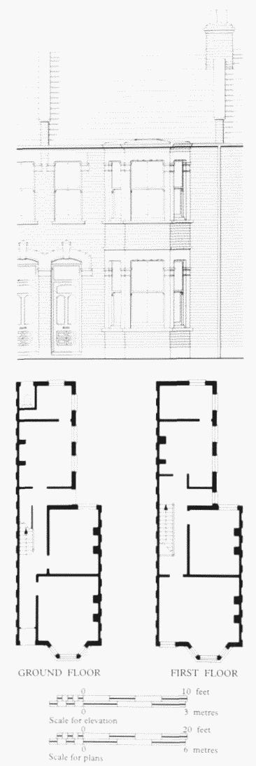
No. 214 East Ferry Road, elevation and plans in 1991.Griggs & Son, builders, 1907
Further house-building in the area took place in the 1880s and 1890s, by which time the boxy terrace house was to some extent giving way to a more imaginative and better-lit pattern. Several houses of the mid-1880s had bay windows to both the street fronts and the back additions. Chapel House Street was extended northwards in 1904, but no further private houses were built. (fn. 54)
Charteris Terrace, Nos 202–224 (even) East Ferry Road, was one of the last terraces of private houses built in the Isle of Dogs until the 1980s (fig. 187). Of somewhat superior quality to the generality of local dwellings, the row of 12 houses was built in 1907 on a 99-year lease at a rental of £4 per plot. The builders and original lessees were Alfred and Frank Griggs (Griggs & Son) of Manchester Road. By the First World War the houses were variously let whole or in halves. (fn. 55)
Millwall Fire Station, No. 461 Westferry Road. This station was built in 1904–5, replacing an earlier one of 1877 on the same site. The need for fire-fighting provision on the Isle of Dogs had been recognized by the 1850s, but William Cubitt's offer to build a fire-engine house on the Island was conditional on his being granted permission to divert some paths in the district into roads and it was not acceptable to the Trustees of the parish. (fn. 56) The need for such a building was recognized by the Metropolitan Fire Brigade in 1872 and in the following year local residents and property owners drew attention to the inadequate fire-fighting provision there. (fn. 57) It was realized that a serious delay could occur if the bridges over the dock entrances were raised when the engines from the West India Dock Road station were responding to an emergency in the area. (fn. 58) The Metropolitan Board of Works's fire-brigade committee investigated possible sites for a station and the Board took a 99-year lease from Lady Margaret Charteris of land at the junction of Westferry Road and East Ferry Road. (fn. 59) The design was prepared in 1876, presumably by Alfred Mott of the Board's Superintending Architect's Department, and his assistants. W. D. Fink was awarded the contract on his tender of £3,133. (fn. 60)
The station was opened for duty on 19 June 1877, with an initial strength of six firemen, a coachman, three horses, a steam fire-engine, a manual engine, a curricle and a fire-escape (Plate 81a). (fn. 61) The building consisted of three parts: the main one, which fronted Westferry Road, was of three bays and four storeys, with a central archway which led to the appliance room. (fn. 62) As was usual, the residential accommodation was on the upper floors.
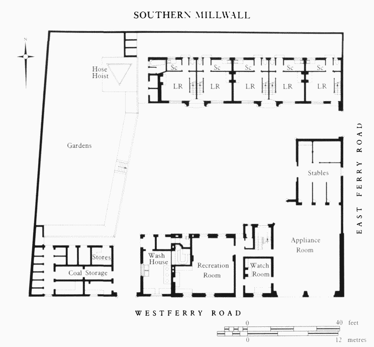
Millwall Fire Station, No. 461 Westferry Road, ground-floor plan as built. LCC Architect's Department (Fire BrigadeSection), 1904–5
In the mid-1890s it was realized that the building was too small. Because of an increase in the number of staff, some of the men had to be lodged in houses in the neighbourhood, and a pair of horses was kept in rented stables. (fn. 63) Additional ground to the rear of the station was acquired, together with the freehold of the original premises, and plans were prepared for the alteration and enlargement of the building. (fn. 64) These plans were not executed and revised ones were produced in 1903, but the estimated cost of carrying them out was such that it was decided that it was preferable to erect a new building. (fn. 65)
Designed by the Fire Brigade Section of the LCC Architect's Department, at an estimated cost of £11,300, and erected by the Council's Works Department, the new station was completed by May 1905. (fn. 66) The main building is of four storeys, in the Queen Anne style characteristic of the LCC fire stations of the period (Plate 81b; fig. 188). It is of red brick, with Doric pilasters picked out in a darker brick, the ground-floor level is in stone, now rendered. A triangular steel hose-hoist tower was erected in the yard. The adoption of motorized appliances rendered the stables obsolete and in 1925 they were converted into a mess room and offices. (fn. 67)
The removal of the requirement that all of the staff should live on the premises and the introduction of the shift system led to the gradual adaptation of the residential quarters for other purposes, although some of the cottages were occupied until the mid-1980s.