Survey of London: Volumes 43 and 44, Poplar, Blackwall and Isle of Dogs. Originally published by London County Council, London, 1994.
This free content was digitised by double rekeying. All rights reserved.
'Cubitt Town: Introduction', in Survey of London: Volumes 43 and 44, Poplar, Blackwall and Isle of Dogs, (London, 1994) pp. 495-497. British History Online https://www.british-history.ac.uk/survey-london/vols43-4/pp495-497 [accessed 24 April 2024]
CHAPTER XVII - Cubitt Town
The south-eastern part of the Isle of Dogs, known as Cubitt Town, was not developed until the mid-nineteenth century. It takes its name from William Cubitt, its developer, who embanked the riverfront and laid out the principal streets during the 1840s and 1850s. William was born in 1791, the second son of Jonathan Cubitt, a carpenter at Buxton near Aylsham in Norfolk. The family moved to London shortly after William's birth. Following a period of service in the Navy, by 1814 William had joined his elder brother Thomas's building firm, which from 1816 was based at extensive premises in Gray's Inn Road. Lewis, the youngest surviving brother, also joined the partnership. In 1827 their association was dissolved; Thomas went into business independently, building on a large scale, notably in Pimlico and Belgravia. William and Lewis continued to manage the firm, which expanded considerably in the 1830s, becoming one of the largest building concerns in early Victorian London. William retired from the business in 1854. He sat as MP for Andover from 1847 until 1861 and again from 1862 until his death in 1863. He was also an Alderman of the City of London and was Lord Mayor in 1860–2. (fn. 2)
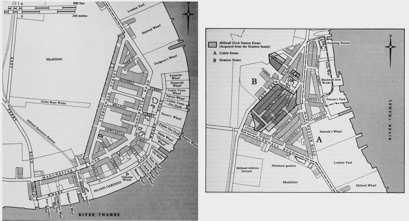
By four agreements made between 1842 and 1853, Cubitt was responsible for the development of much of the district. All but one of the agreements were with the trustees of Margaret Lauretta, Countess of Glengall, daughter and co-heir of William Mellish, who had inherited her father's estate on the Isle of Dogs on his death in 1834. Her trustees, acting with the advice of their agent, John Hooper, first came to an arrangement with Cubitt in 1842, but it is not clear which party made the initial approach. The trustees were aware that the value of the land on the Isle of Dogs was diminishing and their agent was coming under pressure to lower the rents. The land was low lying and its draining and embanking, which were badly needed, could not be effected without a large input of capital. The area had no road access and it was thought at that time that the nature of the ground made it unlikely that a railway could ever be built across it. Moreover, the foreshore was being steadily eroded by the wash caused by steamships, traffic which was obviously going to increase. Without the embankment of the riverside and the drainage of the inland areas the value of the estate could not be increased and was likely to diminish. It was anticipated that Cubitt's investment in the strip of land around the riverfront would benefit the adjoining parts of the Mellish estate by opening them up for development, particularly for house building. (fn. 3) (fn. 1)
The first articles of agreement between the trustees and Cubitt were concluded in July 1842 and related to a belt of land, generally between 475ft and 650ft wide, with an inland boundary running roughly parallel to the foreshore. (fn. 4) Much of the land lay on the outer side of the Marsh Wall, which was 463ft from the edge of Cubitt's holding at the furthest point, but only 48ft from it at the nearest. The boundary ran for 5,004ft from Ferry Street to a point close to the Folly Inlet. The land was demised for 99 years at an annual rent which rose in 12 stages; from £325 in the first year, increasing by £100 annually for the next four years, and rising more unevenly to £1,200 in 1853, with a final increase to £2,100 in 1862. Cubitt contracted to expend at least £10,000 in the first five years in the 'substantial improvement' of the property. The improvement was specified as embanking, wharfing, road making, draining and fencing, as well as building warehouses, factories and houses. A carriage road, at least 60ft wide, was to be constructed along the inland boundary, the trustees and Cubitt sharing the cost, and Cubitt also undertook to make provision for public access to the river at three points along the frontage. The trustees were to issue the leases to the tenants until the aggregate rents reached the level of Cubitt's final annual rent of £2,100; thereafter Cubitt was to be the lessor.
The second agreement, concluded in 1847, (fn. 5) added a further 14½ acres. Cubitt was to continue the carriage road along the new boundary, which consisted of two sections that straightened out the former line on the west side of the earlier take, adding a narrow strip of ground there, and a third section running north-westwards to East Ferry Road. This boundary is marked by the line of Manchester Road northwards from its junction with Glenaffric Avenue as far as Glengall Grove and then along that street to East Ferry Road. The irregular northern boundary, abutting upon the land of William Stratton, was modified by an exchange of land agreed in 1862. (fn. 6) Cubitt contracted to erect buildings 'when and as it shall appear to him to be judicious to do so'. The term was 95 years, terminating at the same date as that agreed in 1842, and the annual rent was £115.
Cubitt Town, c1900. Broken line indicates the boundary of Cubitt & Company's land. a: Southern Cubitt Town; b: Northern Cubitt Town
Cubitt's third agreement with the Countess's trustees was made in 1853 (fn. 7) and added an area of approximately 20 acres on the west side of Manchester Road. Stebondale Street was subsequently laid out close to the line of the new boundary. (fn. 8) The term was for 99 years from March 1852 and the initial rent was £140 per annum, rising to £177 after seven years, to £210 after a further seven years and to £250 from 1873. Cubitt was committed to spend £5,000 upon improvements within the first five years, specifically by raising the level of the ground, draining, fencing, making roads and erecting buildings.
Cubitt took no further land on the Glengall estate, but, by an agreement made with William Stratton in 1850, he added a little over eight acres to the north of his existing holding. (fn. 9) This was granted for a 99-year term at £64 2s 6d per annum. It was bounded on the east by the Marsh Wall and on the west by a section of Manchester Road - between its junctions with Samuda Street and East Ferry Road - that was laid out by Cubitt as a condition of the agreement.
The area bounded by Manchester Road, East Ferry Road and the rear of the premises in Glengall Grove and Strattondale Street was not taken by Cubitt, although it was a part of the district which, by the early 1850s, had become known as Cubitt Town.
Cubitt Town contained two principal elements; the industrial sites and the housing. There was little demand in the Isle of Dogs for industrial land that did not abut upon the river or the docks, and so the two components were generally distinct, with most of the industry concentrated at the wharves and along East Ferry Road, and the housing in the remainder of the district (fig. 190).