Survey of London: Volumes 43 and 44, Poplar, Blackwall and Isle of Dogs. Originally published by London County Council, London, 1994.
This free content was digitised by double rekeying. All rights reserved.
'Southern Blackwall: Naval Row area', in Survey of London: Volumes 43 and 44, Poplar, Blackwall and Isle of Dogs, (London, 1994) pp. 634-640. British History Online https://www.british-history.ac.uk/survey-london/vols43-4/pp634-640 [accessed 19 April 2024]
In this section
Naval Row Area
This area is bounded on the north by the perimeter wall of the East India Export Dock and on the west by Blackwall Way. The southern and eastern boundaries now completely obliterated - are, respectively, the former London and Blackwall Railway and the southern arm of East India Dock Wall Road (fig. 239).
Once part of Poplar East Marsh, this area was formerly traversed by the old east-west road from Poplar High Street to Orchard House, whose site now lies to the south of Naval Row. During the eighteenth century all the land here was gradually acquired by the owners of Blackwall Yard, and the ground on the south side of the road was mostly taken into the shipyard, providing a site, amongst other things, for a substantial portion of the famous mast-house built by John Perry in 1780–1 for Brunswick Dock (see page 563). This stood within the area later occupied by the Great Northern Railway's goods depot. Most of the land was held by the successive owners of Blackwall Yard until the late 1830s, when the London and Blackwall Railway Company bought a large slice of the area in order to extend its line to Brunswick Wharf.
Naval Row
The present roadway was laid out in the early nineteenth century, and takes its name from a terrace of seven houses erected about 1782 on the north side of the old road from Poplar High Street to Orchard House (fig. 209). (fn. 1) Called Naval Row, (fn. 2) these houses were built by the owner of Blackwall Yard, John Perry, almost certainly as accommodation for some of his employees - in the early years of the nineteenth century the occupants were mostly 'officers in the shipyard'. (fn. 3) The houses were originally two storeys high with basements and attics: they are just discernable in Daniell's 1808 panorama of the East India Docks (Plate 148b). If Perry used an architect it is likely to have been John Powsey, his surveyor. Four of the original seven houses - latterly Nos 16–22 (even) Naval Row — were not demolished until after 1945.
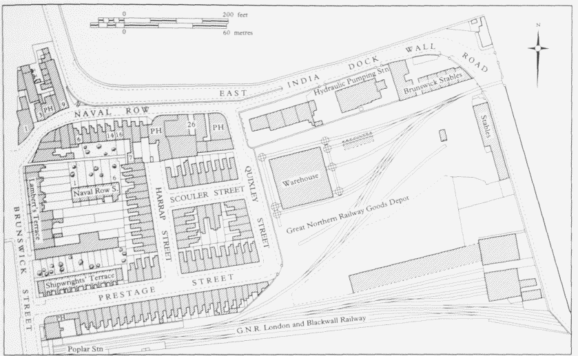
Naval Row area. Plan based on the Ordnance Survey of 1895
The old road to Orchard House was severed by the construction of the East India Docks in 1803–6, and about 1810 the surviving (western) section was closed, being replaced by a new road — the present Naval Row laid out to the north to improve access to the export dock. Its route lay between the backs of the houses in Naval Row terrace and the perimeter wall of the import dock, which at that time stood to the south of its present line. As a result of this change the orientation of the houses in Naval Row terrace was reversed. The former backs, shorn of their gardens, now faced the new roadway, while the former fronts overlooked new gardens laid out across the site of the old road. The old road did not disappear entirely. A stretch of footpath opening off Brunswick Street (Blackwall Way) was allowed to remain — later providing access to the houses known as Naval Row South — and it lingered on until the area was cleared after the Second World War.
After the re-alignment of the road, Perry's successors at Blackwall Yard sold the freehold of the original houses, and of the land to either side fronting the new roadway. In 1810 the easternmost house, and the adjoining land up to what is now Quixley Street but was then an entrance into Blackwall Yard, was bought by Simon Kingsell, plumber, painter, glazier, lead manufacturer and gentleman. Kingsell had been living in Naval Row since 1789 — latterly in the easternmost house - and the adjoining land eastwards was already occupied by his lead-works, described in the 1810 conveyance as 'lately erected'. (fn. 4) They comprised a collection of single-storey buildings in both brick and wood with pantile roofs, which included a mill, a counting-house, a chaise-house, stables, a glazier's shop and a plumber's shop. Kingsell became bankrupt in 1816, and in 1823 his former premises in Naval Row were taken over by Henry Pinchard, a colour manufacturer in Limehouse. (fn. 5) By 1841 the old house was in the hands of a port and ale merchant, who had established the Steamship public house there by 1842 (see below). This was soon joined by another public house, the Prince of Wales, at the west corner of Naval Row and Quixley Street, which first appears in directories in 1846. (fn. 6)
The westernmost house in Naval Row terrace, together with the land up to the corner with Blackwall Way, was by 1817 in the hands of Thomas Lambert, a carpenter, who set up workshops there. (fn. 7) In 1855 a builder from Bromley, George Tanner, erected a row of five small twostorey houses on the eastern part of this site, later numbered 6–14 (even) Naval Row. Now all demolished, these houses had single-storey flat-roofed kitchens built out in front facing the roadway, while their south-facing backs overlooked a communal garden. (fn. 8)
The north side of Naval Row consists mainly of a listed brick retaining wall, capped with iron railings, which holds back the ground under a rising stretch of what was formerly part of East India Dock Wall Road. The latter was laid out in 1833–4 to give access to the newly opened Brunswick Wharf, and as there was insufficient room for the new road between Naval Row and the high boundary wall of the East India Import Dock a section of the wall had to taken down and rebuilt further back. For just under 400ft the two roads ran side by side; where they diverged there is a connecting flight of steps for pedestrians, recently rebuilt and widened. This stretch of East India Dock Wall Road was later closed and the area planted with trees and shrubs as part of Tunnel Gardens, opened in 1902 (see page 640). The only buildings on the north side of Naval Row were all at the west end (Plate 107b), partly above the site of the entrance to the second Blackwall Tunnel. Latterly numbered 1–9 (odd), they included a public house, the East India Arms (at No. 5), shops, a smithy and a warehouse. (fn. 9) Behind them was Steven's Acre, a slum court erected in the 1840s and later cleared for Tunnel Gardens (see page 193). In 1991–2 part of this site was used to build a Traffic Control Centre for the Metropolitan Police.
No. 24 Naval Row: The Steamship public house.
The present building was erected in 1885 (Plate 105d), but there has been a public house here called the Steamship since 1842. It then occupied the easternmost house in the original Naval Row terrace, to which the adjoining house westwards was added in 1845. (fn. 10) The 1885 building stands on the site of both those houses. Designed by Edward Brown of Spitalfields, an architect who apparently specialized in public houses, the new premises were erected by Jackson & Todd of Hackney Road on their tender of £2,175, and paid for by the brewers, Truman, Hanbury, Buxton & Company. (fn. 11)
Built of brick, now largely overpainted, the main part of the building is three storeys high, above a basement, and four windows wide. Almost the only ornamental features are the keystones over the windows and the continuous hood-moulding which connects them. The main building lies back from the road because its front originally aligned with the backs of the older houses in Naval Row, and the space up to the pavement is largely filled by a single-storey extension, faced with glazed tiles. This appears to have been built in 1885 and formerly contained a sales counter, as well as bars. A 'club room' was added in 1890, probably at the back. (fn. 12)
No. 26 Naval Row.
Standing on part of the site of Simon Kingsell's early nineteenth-century lead manufactory, No. 26 comprises a group of single-storey workshops and stores of uncertain date, and a two-storey building of 1910 with just a hint of Art Nouveau in its pleasingly detailed elevation on Naval Row (Plate 107c; fig. 240). Designed by Alfred Roberts, FRIBA (1865–1936), of Greenwich, (fn. 13) the two-storey building was erected for John Wright & Sons, painters and plumbers, and originally contained offices on the ground floor and a warehouse above. The architectural 'effects' are concentrated on the street front, where, on the ground storey, bands of stock brick alternate with white-painted stonework. Stone is also used for the two dentilled cornices, one above the ground-floor windows and one over the firstfloor windows. The elevation is finished by a stone-coped brick parapet whose sinuous form is mirrored by the stone apron under the main ground-floor window. An original doorway to the west of this window has been sensitively blocked up.
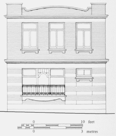
No. 26 Naval Row, front (north) elevation. AlfredRoberts, architect, 1910
East of Quixley Street, Naval Row merges into the surviving stretch of the East India Dock Wall Road, so while the flats at the corner of Quixley Street are numbered in Naval Row, the former hydraulic pumping station next door is not. The land on the south side of the road, to a depth of some 50ft, belonged to the East India Dock Company, having been acquired early in the nineteenth century, but little use was made of it until 1834, when the company erected stables and coachhouses there for letting to stage-coach and omnibus proprietors willing to operate services between the City and the newly opened Brunswick Wharf. Two sets of stables and coach-houses were built, their corner sites being separated by the plot later allocated to the pumping station. James Walker, the dock company's engineer, drew up the plans, and Thomas Lambert, the carpenter in Naval Row, undertook the construction work on his tender of £1,449. The first lessee of the premises, in 1835, was Robert Lambert, a local coach proprietor and presumably a relative of the builder. (fn. 14) Both sets of stables survived into the twentieth century, and those at the east corner, by then called Brunswick Stables, were still standing in 1947. (fn. 15)
No. 36 Naval Row: Naval House.
Erected in 1928–9 by the Borough of Poplar, this block of flats at the east corner of Naval Row and Quixley Street stands on the site of one of the two sets of stables built in 1834 for letting to coach and omnibus operators. It was designed by the Borough Surveyor, Harley Heckford, and is in the simplified neo-Georgian style favoured by the Borough for its public housing in the 1920s. The builder was R. A. Reader of Hackney, whose tendered price was £8,997, and the total cost of the scheme, including the land (purchased from the PLA), was £10,802. (fn. 16)
Constructed of yellow brick, with red-brick dressings, the building comprises a four-storey central block flanked by two projecting wings of equal height. It has a hipped Welsh-slate roof and sash windows with wooden frames and glazing-bars. Access to the 16 two-bedroom flats is by balconies on the front elevation, whose iron railings were recently elaborated to give a more decorative appearance.
In 1939 the Council proposed to call the flats 'Hawes House', after Esther Hawes, the founder of the Bazely Street almshouses, then planned for demolition (see page 187). Not surprisingly, the tenants objected to such a phonetically ambiguous name, and in 1947 the name Naval Row Flats was adopted. (fn. 17) Since being sold by the Council in the mid-1980s, and privately refurbished, the block has been renamed Naval House.
The former Hydraulic Pumping Station, East India Dock Wall Road.
This distinctive building with its eye-catching accumulator-tower was erected in 1857 to provide a supply of hydraulic power for the East India Docks (Plate 108c; fig. 241). It was extended in 1877–8, when a new engine room was added at the west end, but this addition was carefully designed in matching style and blends inconspicuously into the older building.
Hydraulic power was introduced at the East and West India Docks in the 1850s, and used initially to operate cranes. The first two pumping stations, both in the West India Docks, were built in 1855 and 1856. The station for the East India Docks was the third to be built, and is the only one of the five hydraulic pumping stations erected in the East and West India Docks system still standing. It has, however, lost all its hydraulic machinery. (fn. 18) This was purchased from the firm of William Armstrong & Company, who had also supplied the machinery for the West India Docks stations. Armstrong & Company were doubtless closely involved in the layout and planning of the stations, but the buildings themselves were probably designed by the dock company's own engineer, Henry Martin, and his staff. The East India Dock Wall Road station was erected by G. J. Watts, a builder regularly used in the docks at this time, who in August 1857 contracted to carry out the work for £5,238. (fn. 19) The expensive hydraulic machinery, costing an estimated £15,700, was installed in the new station between January and July 1858. (fn. 20)
By the early 1870s demand for hydraulic power at the East India Docks had outstripped capacity, and in 1873 an attempt was made to overcome this by linking together the separate East and West India Docks systems, but without success. (fn. 21) The construction in the mid-1870s of a new entrance lock with hydraulically operated gates, and the building of a range of warehouses all fitted with hydraulic cranes beside the newly enlarged East India Dock basin, further increased the demand for power. In 1876, therefore, the dock company authorized its engineer, A. Manning, to install an additional 100hp steam engine at the East India Docks pumping station, for which a new engine house was constructed at the west end of the existing building in 1877–8. Manning himself was presumably responsible for its self-effacing design; the contractors were J. Perry & Company. (fn. 22) In 1925 the steam pumping machinery was replaced by electrically driven pumps purchased from the Hydraulic Engineering Company Ltd of Chester at a cost of £8,463. (fn. 23)
Possibly because the East India Docks pumping station was built next to a public road rather than behind the fortress-like walls of the docks themselves, the architect was permitted - at least on the road-facing north elevation — a greater degree of architectural elaboration than was the case with the earlier West India Docks stations. Built in a style loosely derived from northern Italy, the station is constructed almost entirely of stock brick, and consists of a three-bay single-storey building - with a gabled central bay - at the east end of which is a square campanile-like tower for the accumulator. In the centre of each bay is a round-headed doorway dressed with prominent brick voussoirs: round-headed windows flank the doorway in the later western bay. Behind this quasisymmetrical façade, the building is divided into three sections which increase in width and depth from east to west. The two earlier eastern divisions are separated by two tall cast-iron columns. The accumulator tower is a two-stage structure rising to 55ft, with a shallow pyramidal roof and finial: blind arcarding decorates the sides of the tower. Originally the chimney was at the west end, but when the building was extended in the 1870s it was rebuilt on the south side: the chimney does not survive.
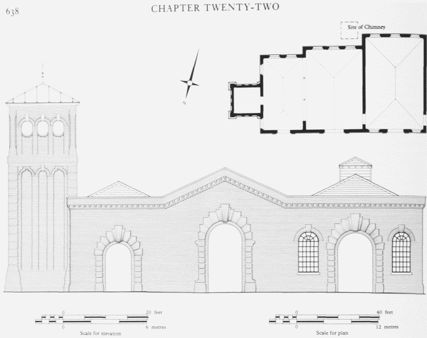
Former Hydraulic Pumping Station, East India Dock Wall Road, north elevation and plan, Built 1857, extended 1877–8
In 1959 the PLA sold the station for £10,000 to the London Hydraulic Power Company, which agreed to sell back to the PLA the power needed for the East India Docks. (fn. 24)
Blackwall Way, Shipwrights' Terrace and Naval Row South
The north-east side of Blackwall Way - between Naval Row and the site of Poplar Station - was mostly built up during the 1820s, when the road was known as Brunswick Street. At the north end there was a row of ten houses called Lambert's Terrace, after the local carpenter and builder Thomas Lambert, who leased a number of plots there in 1821. (fn. 25) Other plots were taken by Thomas Snook of Cotton Street, and Thomas Gladstone of Pickering Place, Cotton Street, both of whom are described as ship-breakers. (fn. 26) Nothing of this range survives, but the appearance of the two northernmost houses, later Nos 3 and 5 Brunswick Street, was recorded in drawings made at the time of the construction of the Blackwall Tunnel (fig. 242). Their elevations are typical of the 1820s - though the round-headed window on the ground floor is one of the less common variants and the plans doubtless followed the standard pattern. The northernmost house (No. 3) was unusual in having a wholly bowed front. Further south in Brunswick Street there was another row of houses, erected in 1828–9, called Brunswick Terrace, which was largely demolished about 1840 for the construction of Poplar Station. The building plots here were originally leased to Thomas Snook, then of Brunswick Street, who sub-let them to Thomas Edward Snook of Millwall, a shipwright, and Richard Winsall of Poplar High Street, a master mariner. (fn. 27)
Another development of the 1820s was Shipwrights' Terrace, a row of 13 almshouses erected in 1821 by George Green, the shipbuilder and proprietor of Blackwall Yard, for retired shipyard workers. (fn. 28) Situated to the south of Lambert's Terrace, it was built at right angles to the street, and the houses faced northwards overlooking gardens; access was originally by means of a pathway between the gardens and the fronts of the houses. No illustration is known, but plans show that the wider central house had a slight projection, and it seems likely that the main, north elevation was symmetrically composed. At the time of the 1841 census at least eight of the houses were occupied by retired shipwrights: in 1895 the central house was being used as a reading-room. (fn. 29) Shipwrights' Terrace was replaced in 1897 by Prestage Buildings, five blocks of four-storey model dwellings for the working classes erected by Percival Hart of West Green Road, South Tottenham, who also owned the freehold. They comprised two-and three-room dwellings, each having its own scullery. (fn. 30) Prestage Buildings were demolished in the 1950s.
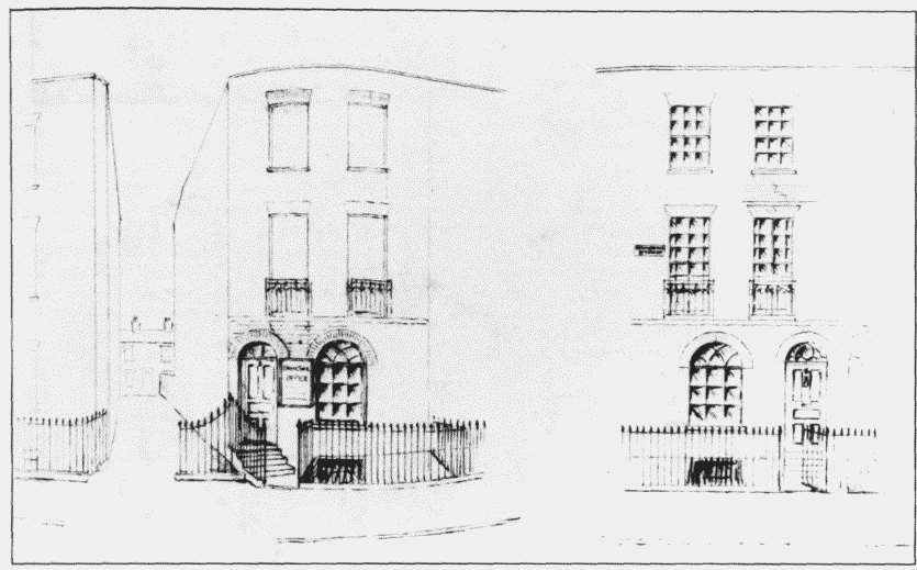
Nos 3 (left) and 5 Brunswick Street (Blackwall Way). Elevations sketched in the 1890s of houses built in the 1820s. The passage between the houses on the left leads to Naval Row South; in the distance is No. 7 Naval Row South (1885). Demolished
Tucked in behind Lambert's Terrace were six twostorey cottages with basements known as Naval Row South. These north-facing houses had long front gardens but no street frontage, and the only means of access was the footpath on the site of the old road to Orchard House. They were in existence by 1841, having almost certainly been built by Thomas Lambert, whose heirs owned the freehold at the time of the Inland Revenue Valuation in 1909–15. (fn. 31) The house known as No. 7 Naval Row South did not form part of the terrace: built in 1885, (fn. 32) it occupied a gardenless site fronting directly on to the footpath at its eastern end (fig. 242).
Harrap, Prestage, Quixley and Scouler Streets
In the late 1850s and early 1860s an area to the south of Naval Row and west of Quixley Street was the scene of a small residential development of which nothing now remains apart from some vestiges of the street pattern. The land here belonged to the London and Blackwall Railway Company, which had bought the northern half of Blackwall Yard in the late 1830s in order to extend the London and Blackwall Railway to Brunswick Wharf. Only a relatively small area was needed for the railway tracks, and in 1857 the company's architect and surveyor, (Sir) William Tite (1798–1873), drew up plans for building on the surplus land to the north of the railway, 'with a view to the sale of the ground rents'. Tite's original scheme envisaged development both east and west of a new north-south road, aligned on the old entrance into Blackwall Yard from Naval Row, to which he gave the provisional name of Dock Street: it was soon renamed Quixley Street. (fn. 33) In the event, however, house-building was confined to the area west of Quixley Street. The other new roads (with their originally intended names in brackets) were Prestage (Railway) Street, Harrap (Bath) Street and Scouler Street. Prestage Street was aligned so that the backs of the houses in Shipwrights' Terrace, just off the railway's property, occupied the north-west frontage of the new road. The railway company paid for making the roads and the sewers, the contract being awarded to J. Perry, whose tender was for £1,288. (fn. 34)
When completed in 1861 the development comprised 66 small brick-fronted dwelling houses and a public house - the Ivy House, at the south corner of Prestage Street and Blackwall Way (fig. 239). The standard house-type was a six-room dwelling, two storeys high and two windows wide, with a two-storey extension behind. At least three different builders were involved in the development: James R. Amery of Walworth, Joseph Tyler of Blackwall, and Robert Ward of Poplar. (fn. 35)
By the time of the 1861 census all but one of the houses were inhabited, and several were already in multioccupation. One (later called Blenheim House), on the south side of Scouler Street, was occupied as a lodginghouse. The majority of householders in 1861 were bluecollar workers, with the 23 shipwrights predominating. Other well-represented occupations were ship-joiners and engineers. (fn. 36) In 1910 Prestage Street and Harrap Street were described as 'Good Class' streets. (fn. 37)
Many of these houses were destroyed or badly damaged by bombing during the Second World War, and after the war prefabs were erected on the cleared sites (Plate 107a). (fn. 38) Scouler Street sustained the least damage and most of the houses there were still inhabited in the mid1960s, when the GLC proposed that the site should be cleared for the relocation of industrial firms displaced by the second Blackwall Tunnel. (fn. 39) The whole area was bought by the LDDC in 1983, (fn. 40) and the only surviving remnants of this development are the northern end of Quixley Street and two rows of trees which once lined the pavements of Scouler Street.
The Former Great Northern Railway Goods Depot
Tite's scheme for building streets and houses on the area east of Quixley Street was abandoned in 1859, and the site was covered with railway lines and associated buildings. By an agreement with the East and West India Dock Company, the London and Blackwall Railway Company constructed a branch line into the East India Docks, bisecting the site diagonally from south-west to north-east, (fn. 41) and by another agreement, with the Great Northern Railway Company, the London and Blackwall Company built sidings, turntables, a 12-stall stable and a 'substantial warehouse' here. These facilities were leased to the Great Northern Railway Company, and used for the 'purpose of depositing and removing goods carried on the lines of the London & Blackwall Railway Company'. The plans and drawings for the new works had been jointly agreed by Tite and the Great Northern's engineer, W. M. Brydon. (fn. 42) The largest of these undertakings was the warehouse, a two-storey brick building over a brick-arched basement, with a square plan, each side having eight bays and measuring 100ft. (fn. 43) This was situated close to the north-west corner of the site (Plate 107a). The stables were erected on the eastern part of the site against the wall separating the depot from East India Dock Wall Road.
The Great Northern Railway Company's lease was initially for only 20 years, but they continued using the depot after 1879 and subsequently secured a 999-year back-dated lease of the site. (fn. 44)
Enemy action during the Second World War reduced the warehouse to a roofless shell, two of whose four walls were still standing in 1970. (fn. 45) The whole site was bought by the LDDC in 1983 (fn. 46) and has been completely cleared.
Tunnel Gardens
The rebuilding that followed the completion of the Blackwall Tunnel left a long irregularly shaped plot between the northern approach road and the East India Dock Wall. This site had been retained in case a growth in road traffic required a widening of the tunnel entrance and approach road, or the construction of a second tunnel. However, rather than allow the land to remain waste until expansion was necessary, in 1901 the LCC decided to convert it into a public playground. (fn. 47) The plan was for a fully paved playground divided by a brick wall, the northern half for boys and the southern one for girls and infants, with part of East India Dock Wall Road serving as a site for a gravelled and tree-lined terrace for adults watching their children at play (fig. 243).
Tunnel Gardens was opened to the public on 30 August 1902. It was ideally placed, sheltered on either side by the high walls of the tunnel approach and the docks. The raised terrace was planted with trees and shrubs and provided with seats, and the high dock wall behind was covered with creeping plants. Equipment provided for the children included parallel and horizontal bars, skipping posts, giant strides (maypoles), swings and slopes. The total area of the combined gardens and terrace was about two acres, laid out at a cost of around £4,500. (fn. 48)
The maintenance and control of Tunnel Gardens was transferred from the LCC to Poplar Borough Council in 1933. (fn. 49) Most of the gardens were cleared in 1958 to make way for the new northern approach road to the Blackwall Tunnel, although a handful of trees planted by the LCC and part of the raised terrace remain.