Survey of London: Volumes 43 and 44, Poplar, Blackwall and Isle of Dogs. Originally published by London County Council, London, 1994.
This free content was digitised by double rekeying. All rights reserved.
'Leamouth Road and Orchard Place: Historical development', in Survey of London: Volumes 43 and 44, Poplar, Blackwall and Isle of Dogs, (London, 1994) pp. 646-655. British History Online https://www.british-history.ac.uk/survey-london/vols43-4/pp646-655 [accessed 19 April 2024]
In this section
CHAPTER XXIII - Leamouth Road and Orchard Place
The area of eastern Blackwall formerly known as Orchard House was for over 150 years one of the most isolated and least accessible parts of Poplar. It lies at the eastern extremity of the parish where the confluence of the Thames and the meandering River Lea (here called Bow Creek) produces two peninsulas with a thumb-andforefinger-like configuration. The construction of the East India Docks in 1803–6 cut this area off from the rest of Poplar, and made it difficult of access by road. While not inhibiting the industrial development of the district, this encouraged the growth of a poor but self-contained community of whose existence the outside world seemed largely oblivious. 'London's "Lost" Village', as it was called in 1931, had no public transport links with the rest of Poplar, and any would-be visitors were faced with a long walk down the 'forbidding-looking thoroughfare bearing the picturesque name of Leamouth Road, flanked on both sides by the high stark walls of the adjacent dock premises' (Plate 111). (fn. 2) The community here was destroyed in the 1930s, when most of the houses were pulled down under slum clearance orders and their inhabitants moved elsewhere. Local industries, on the other hand, did not move out, and although these have reduced in number, the area is still essentially an industrial or business district, now dominated by the large modern refinery in Orchard Place (Plate 112a).
Early History: Estates and Land Holdings
By the end of the eighteenth century two freehold estates or land holdings, known as Orchard House and Goodluck Hope, accounted for most of the area described in this chapter (fig. 247), and their histories are given below. The only other property holdings of any significant size at this date were parts of two larger estates, one belonging to the proprietors of Blackwall Yard and the other to the landowner Robert Peers. Both were formerly part of Poplar East Marsh, and both were purchased by the East India Dock Company for the making of the East India Docks.
Orchard House Estate
The Orchard House property, or Pemell Estate as it was known in the nineteenth century, was the larger of the two main land holdings, with some 20 acres. (fn. 3) It comprised the whole of the east-pointing peninsula formed by the confluence of the Lea and the Thames, and extended westwards to include areas later swallowed up by successive enlargements of the East India Dock basin.
Also known from its location as Leamouth (or 'Laymouth'), the estate took its name from the Orchard House, a moated property comprising a house and a large orchard, which formerly occupied much of the eastern peninsula. The moated orchard was in existence by at least the late sixteenth century. It is clearly shown on a map of c1573, which also places the house on the east side of the orchard (Plate 145a). (fn. 4) Later maps, such as Gascoyne's of 1703 (fig. 1), show the house at the western end of the orchard, and it was presumably rebuilt on this site during the seventeenth century. Although the orchard disappeared sometime between 1746 and 1769, the surrounding moat survived into the early nineteenth century, but without apparently leaving any permanent mark on the topography. (fn. 5)
In 1666 the estate was bought by Ann Webber of Blackwall, a widow. It was then said to have been the inheritance of John Hammond, deceased, and formerly in the occupation of Ann Sutton, widow. Having contracted to buy the property, Ann Webber, whom a creditor later described as 'altogether illiterate and not understanding anything of such affairs', found herself 'in a great straite for money', and she had to borrow the greater part of the purchase price. For this she turned to a 'familiar friend of hers, one Pickering a known beggar', who had made love to her and had agreed to marry her. Clearly no ordinary beggar, William Pickering was a member of the Merchant Taylors' Company, and had sufficient means to lend Mrs Webber £270, secured on a mortgage of the estate. Although the two never married, they seem to have kept up an association, with fatal consequences for Pickering, for on one occasion when visiting Mrs Webber's 'tippling house in Stepney' he was 'gotten full of drink and . . . drowned in a ditch'. Mrs Webber subsequently defaulted on her mortgage repayments and in the mid-1690s Pickering's administrator, Thomas Carpenter of Stepney, gentleman, gained possession of the Orchard House property. (fn. 6)
It seems likely that Mrs Webber's 'tippling house' in Stepney was in fact the Orchard House, which was occupied as a public house from at least the early eighteenth century and remained a licensed premises until the 1860s. (fn. 7) No illustration of the building is known, but a ground-floor plan of 1773 shows a double-fronted house with four rooms on the ground floor, and a central hall with a staircase compartment behind. Various ancillary buildings to the north and east included a 'Drinking house', a bakehouse, a stable and a cowhouse. In front of the premises there was a skittle ground, while some way to the south-east was a detached summer house or long room overlooking the Thames, later called a tearoom. (fn. 8) The old Orchard House was demolished in the early 1870s, after a survey had reported that it was 'in such an utterly tumble down condition that there is no alteration except to pull it down', and its site was turned into a boat-yard. (fn. 9)
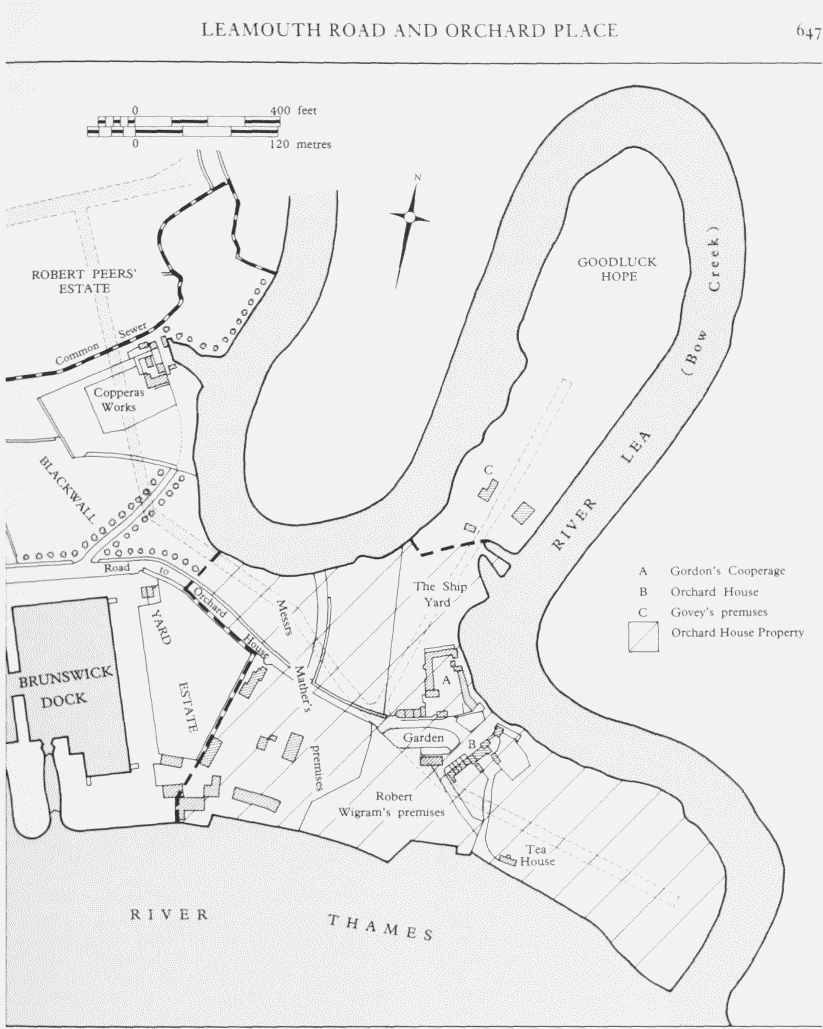
Orchard House and Leamouth area in 1803. Later roads are indicated by stippling
After passing into the hands of Thomas Carpenter in 1695, the Orchard House estate remained in the possession of the Carpenter family until 1743, when Thomas's heirs sold it for £735 to John Wright of St James's Westminster, coachmaker, and his wife. The next owner was James Corson of Deptford, a linen draper, who bought it at auction in 1766 for £1,300. Two years later Corson let the estate on a 99-year lease, thereby creating a separate leasehold interest in the property which existed until 1867. After Corson's death the freehold passed to his widow and then to his daughter Elizabeth Ross, who in 1798 married William Pemell of Deptford, esquire. In 1815 Elizabeth Pemell's son, Peter, sold the entire estate for £5,500 to the East India Dock Company, which wanted to enlarge the East India Dock Basin. (fn. 10)
The first of the leasehold proprietors of the Orchard House estate, under the lease granted by James Corson in 1768, was a local timber merchant, Thomas Weston, who held the property for less than six months. After another brief tenancy the lease was purchased in August 1769 by John Staples, a merchant of Mansell Street, Goodman's Fields, but before the end of the year he had sub-let much of the estate to Benjamin Kemp, a local cooper. Excluded from this lease was a Thames-side plot - now covered by Orchard Wharf - which Staples reserved for his own use as a shipbreaking yard. Kemp's occupation lasted until 1773. (fn. 11) During this time he erected a cooperage immediately to the south of the Orchard House, (fn. 12) and in 1771–2 he sub-let a sizeable swathe of land on the west side of the estate, adjoining the Blackwall Yard property, to Moses Franks, a City merchant. Though split into two halves by the roadway leading to Orchard House, the land leased by Franks had frontages to both the Thames and the Lea. In 1784 Franks's leases were purchased by another City merchant, James Mather, who used the ground to build an establishment for blubber boiling and whale oil extraction (see below). The East India Dock Company bought these leases from Mather's heirs in 1804.
Meanwhile the head lease of the Orchard House estate had changed hands several times. In 1795 it was bought for £1,657 by John Perry, the shipbuilder and proprietor of Blackwall Yard, who in 1798 assigned a half share in the lease to the Rotherhithe shipbuilders, John Wells and William Wells the younger. This was the first of several assignments of shares in the lease which culminated in John Wells becoming the sole owner in 1809. (fn. 13) Shortly afterwards Wells began letting the estate for development, though, of course, he had to exclude those parts which were already in the hands of sub-lessees under existing leases. Wells promoted the construction of two new roads, leading northwards and eastwards from the Orchard House, and the land on both sides of these roads he divided into plots of various sizes, all with river frontages, which he let mainly for industrial or commercial use. (fn. 14) The leases granted by Wells between 1811 and 1813 established a pattern of property holdings in the area which is still discernible today, although none of the plots leased by Wells retains its original integrity.
In 1817 Wells assigned the lease to Money Wigram, the Blackwall Yard shipbuilder, and Charles Richardson, esquire, of Limehouse. This was not, however, a straightforward transaction. Only a third interest in the lease belonged to Wigram and Richardson, the remaining two thirds being held in trust by them for Wigram's partner, the shipbuilder George Green, and for James Walker, the engineer and surveyor. (fn. 15)
The reversion of the Pemell Estate finally passed into the hands of the East and West India Dock Company, the freeholders, in 1867, when the head lease granted in 1768 expired. It was hoped that this event, long anticipated by the Dock Company (which had ordered a survey and valuation of the property in 1865), would provide an opportunity to dispose of the whole estate for 'some great undertaking'. For a number of years, therefore, the company had been refusing reversionary leases to the sitting tenants, and after 1867 would grant only shortterm leases, of seven years or less, even though this meant that the property was difficult to let. Another survey was ordered in 1870 and it revealed, not surprisingly in view of the prevailing uncertainty, that much of the estate was in a poor and deteriorating condition. The directors still clung to their vision of letting the whole for a single enterprise, but when none was forthcoming they had to admit defeat and embark upon a policy of leasing and selling individual sites which led in time to the complete dismemberment of the estate. (fn. 16)
Goodluck Hope - The (Fitz) Wigram Estate
The second largest land holding in the area at the beginning of the nineteenth century comprised most of the north-pointing thumb-like promontory embraced within the last loop of the River Lea before its confluence with the Thames. Formerly part of the demesne of the manor of Stepney, this peninsula of some nine acres was known in the fourteenth century as Godelockhope or Godluckhope, and more recently as Goodluck Hope. By 1440 it was divided into two holdings, one of which was described as a hope of reeds with a fishery, and the other as a farm with grazing on the wall in the East Marsh. (fn. 17) The manorial survey of 1652 describes it as a piece of marsh or meadow then in the occupation of Widow Sutton (presumably Ann Sutton, the occupant of Orchard House). At this date some land on the west side of the peninsula was still copyhold. (fn. 18) Goodluck Hope appears to have become independent of the manor by the end of the seventeenth century, and over the next hundred years it passed through several changes of ownership. (fn. 19) In 1800 the purchaser was Richard Govey of Poplar and Blackwall, variously described as cooper and gentleman. (fn. 20) By 1804 much of the area was in the occupation of the East India merchant (Sir) Robert Wigram, bart (1743– 1830), one of the proprietors of Blackwall Yard and a director of the East India Dock Company, who purchased the freehold from Govey in 1810. (fn. 21)
Wigram subsequently extended his property holdings in the district by purchasing four separate pieces of the Orchard House estate from the East India Dock Company; one of these pieces was contiguous to his Goodluck Hope property. (fn. 22) Later sales reduced the size of the Wigram estate, parts of which continued in the ownership of the FitzWigram family (Wigram's descendants) until well into the twentieth century.
The area remained largely undeveloped until the nineteenth century, and the only earlier building there of any consequence was a mysterious house called Hanbury or Handelbury Hall, about which little is known. Situated near to the boundary with the Orchard House property, it was probably erected in the first half of the eighteenth century, and is doubtless the 'Handlebey Hall' shown on Rocque's map of 1746, even though the cartographer managed to place it on the Essex side of the Lea. (fn. 23) For a few years in the 1770s it was occupied by the cooper Benjamin Kemp. (fn. 24) The house had been demolished by 1804. (fn. 25)
Roads
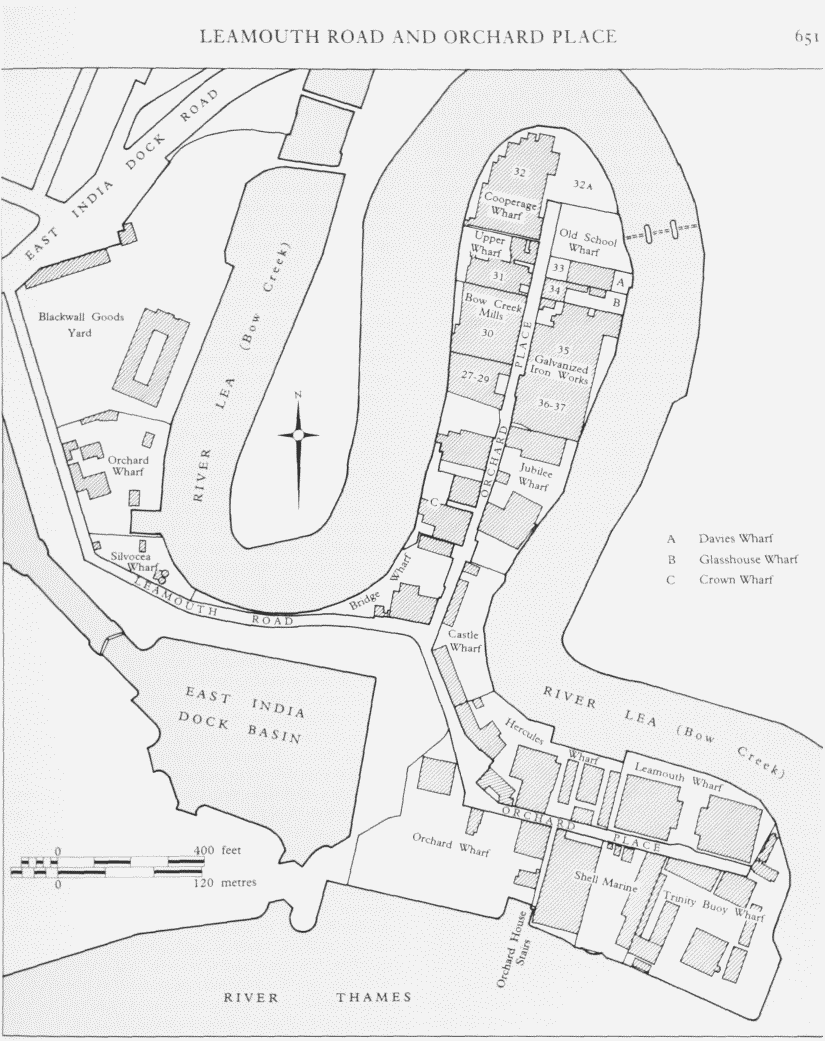
Before the construction of the East India Docks in 1803–6, the Orchard House area was linked to the old centre of Poplar by a road leading eastwards out of Poplar High Street, which dates back to at least the second half of the sixteenth century. (fn. 26) When the building of the docks severed this connection it was replaced by a new northsouth road joining Orchard House to the East India Dock Road. This new road was laid out by the East India Dock Company on the ground between the docks and the River Lea. It was at first known as the road to Orchard House (fn. 27) and later Orchard Street, being renamed Leamouth Road in 1914. For much of its length it was formerly enclosed between high brick walls. Its route has been changed more than once, to accommodate successive enlargements to the East India Dock Basin, and in the last few years it has been substantially widened.
The eastern arm of Orchard Place and the southern end of the northern arm were formed in 1811–12 to facilitate John Wells's letting of much of the Orchard House estate for development. (fn. 28) The new eastern road superseded an earlier road laid out further to the south on top of the old marsh wall. (fn. 29) This older road had been constructed a decade before to provide access to the Trinity House Buoy Wharf at the confluence of the Thames and the Lea. Originally known as the new road to Trinity Buoy Wharf, the 1812 road was later known, probably informally, as Trinity Road. (fn. 30) In the late 1860s it was called Orchard Street by the Ordnance Survey, but in the directories is listed as Orchard Place, though this name was not officially adopted until 1891. The northern arm of Orchard Place originally stopped at the boundary between the Orchard House estate and the FitzWigram estate (Goodluck Hope), but was extended northwards to the glass works in the mid-1830s. It was further extended in the 1870s, after the glassworks closed, when the site was divided up for development.
Leamouth Road and the northern arm of Orchard Place were formerly connected by Lea Passage, a convenient short cut for pedestrians and light traffic (see fig. 248). Laid out by the East India Dock Company in 1817, Lea Passage originally hugged the banks of the Lea for most of its length, but it was re-routed away from the river in the mid-1870s, when Leamouth Road was moved northwards to allow for enlargement of the East India Docks Basin. Lea Passage was closed altogether in 1969, when its site was absorbed into the adjoining wharf.
Industrial Development
The remoteness of the district did not hinder its industrial development. Indeed, for some industries, whose processes produced noxious smells and fumes, it could be an important consideration in choosing a location. Another advantage was the area's easy accessibility by water, which compensated for the lack of good road links. Both of these factors played a part in the siting of the Gas Light & Coke Company's tar refining distillery in the district in 1818–19 (see page 669).
Although most development took place in the nineteenth century, the area has an industrial history which extends back to at least the mid-seventeenth century, when the copperas works was established on the west bank of the River Lea (see page 661). In the eighteenth century the banks of both the Lea and Thames were used for shipbuilding and shipbreaking, but Blackwall Yard was the only important shipbuilding concern in the area until the mid-1790s, when William Wallis established his yard hereabouts. Two other very different industrial enterprises found a niche here in the latter part of the eighteenth century: one was coopering and the other blubber boiling. The latter did not long survive the turn of the century, but the coopering trade continued in the district until about 1870.
Coopering was established here by the early 1770s, when the sub-lessee of much of the Orchard House property, Benjamin Kemp, himself a cooper, erected a cooperage immediately to the south of the Orchard House. (fn. 31) This consisted of three ranges of buildings disposed around three sides of a quadrangle, the south side being left open. (fn. 32) Another local cooper, Richard Govey, built a cooperage at the southern end of the Goodluck Hope peninsula shortly after purchasing the property in 1800, (fn. 33) but the largest of these concerns was that belonging to Kemp's son-in-law, the cooper Robert Gordon. (fn. 34) Established by 1796, (fn. 35) Gordon's premises were laid out around a quadrangle on a Lea-side site to the north of the Orchard House now partially covered by Castle Wharf and Hercules Wharf (see fig. 247). Gordon's original premises were demolished when the site was taken over by the shipbuilders Ditchburn & Mare in the 1840s, although they retained the name 'The Cooperage' (see fig. 259), but in the later 1860s the site was again in the hands of a cooper, Edwin Dickenson. Robert Gordon and his heirs had meanwhile taken over the adjoining site to the north. where they maintained a modest business until the early 1870s. (fn. 36)
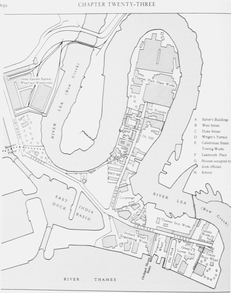
Orchard Place and Leamouth Road area. Plan based on the Ordnance Survey of 1867–9
Orchard Place and Leamouth Road area. Plan based on the Ordnance Survey of 1969–74
The boiling and processing of whale blubber began here in the early 1780s. After being landed from the Greenland ships the blubber had to be boiled and 'trained' to extract the oil, which was used in soap-making, woollen cloth manufacture, and in lamps. This so-called 'Greenland Trade' was at its height in the 1780s, and London was the most important departure point for British whaling ships, many of them leaving from the Wells family's Greenland Dock in Rotherhithe. The principal entrepreneur here was James Mather, a City merchant, who in 1784 acquired a sub-lease of a substantial swathe of the Orchard House land on which to carry out the business. (fn. 37) (fn. 1) Mather's property, which was on the west side of the estate next to Blackwall Yard, had frontages to both the Thames and the Lea, though it was split in two by the road to Orchard House (see fig. 247). On the southern part of this site, next to the Thames, Mather erected a boiling house containing huge coppers in which the blubber was boiled and trained, and warehouses for storing the oil and the valuable whalebone, which was used to make knife handles, sieves, brushes, ornamental window-blinds, trellises and guards for shop-windows, chair seats and garden fences. (fn. 39) After the opening of the Brunswick Dock in 1790, Mather leased part of the east quay and some adjoining land behind the quay giving him direct access to the dock from his own premises. Under the terms of the lease, which was for 74 years from 1792, Mather could 'Land Casks containing Blubber or Materials from which oil is or may be extracted from Shipping lying in the said Brunswick Dock'. The rent for the quay was only £5 per annum, but Mather had also to pay a toll of one shilling per ton on the blubber landed, and to ensure that this was correctly calculated he had to provide the proprietor of the dock, John Perry, with a 'full account' of all the oil trained, boiled or extracted from the blubber. (fn. 40)
After Mather's death in 1796 the business was continued by his three sons until about 1803, when the works were rendered 'useless' by the East India Dock Company's purchase of the Brunswick Dock for its new docks. By this date London had ceased to be an important centre for the whaling trade, which moved north to the ports of Hull and Whitby. In 1803–4 the Mathers disposed of all their premises to the East India Dock Company. (fn. 41) The few inhabitants of the area were doubtless relieved to see the end of a thoroughly noxious trade, whose stench must have permeated every corner of the district.
The first half of the nineteenth century saw a great expansion of industry in the area. The river sites were initially attractive to shipbuilders like Gladstone, Snook & Company, the Samuda brothers, R. & H. Green, and Ditchburn & Mare, although they were often quite restricted and offered relatively little scope for expansion when business increased. The Samudas had set up their yard on the eastern side of Goodluck Hope in the 1840s, but were so hemmed in that in order to expand they had to re-locate to Cubitt Town. Mare & Company (successors to Ditchburn & Mare) overcame the same problem by expanding on to the marshes on the Essex side of the Lea, while maintaining a ferry link with their premises on the north side of Orchard Place (see fig. 259). The largest single concern in the area, however, was not a shipbuilding yard but the great glass works of the Thames Plate Glass Company, which occupied the north end of the Goodluck Hope (fig. 256). Opened in 1835, it was probably the largest employer of labour in the district, though being a very specialized activity many of its workers were migrants from the older glass-making centres in the north of England. Other smaller concerns ranged from a Roman cement works (whose basic raw material was delivered to the site by barge), to tar and turpentine distilleries and a marine engine manufactory, conveniently located beside the Thames, where ships requiring new engines or refitting could moor alongside.
In the second half of the nineteenth century the most far-reaching industrial change was brought about by the closure of the plate-glass works in 1874 and the subsequent colonization of the site by other industries. Among the first to establish premises there were a firm of seed crushers, a railway steel axle-box company, a sack and bag company, and a firm of sugar refiners. But from the first the dominant presence was the Blackwall Galvanized Iron Company, which, as a branch of the giant steel combine Richard Thomas & Baldwins, survived here until the 1960s. From its initial three sites the firm expanded until it was at least as large if not larger than the glass works which preceded it. Elsewhere in Orchard Place large-scale shipbuilding was on the decline, and although the Thames Iron Works & Ship Building Company (successors to Mare & Company) retained a foothold there until the end of the century, the firm had long given up building ships on the Middlesex side of the Lea. The tradition of shipbuilding lived on, however, in a number of small yards turning out boats and barges.
Except on the glass-works site, manufacturing industry was declining. Thus, when the marine engine works at Orchard Wharf went out of business in the 1870s, the premises were taken over by a firm of wharfingers. Similarly, the old cooperages beside the Lea were replaced by ranges of warehouses, stores and workshops for a shipping line. On the old cement works site a new iron foundry lasted for less than three years in the early 1870s, being succeeded by an asphalt works which survived for almost a century.
Today manufacturing industry in the area is largely confined to the Goodluck Hope peninsula, where Messrs Acatos & Hutcheson's vegetable-oil refinery maintains the tradition of a large manufacturing concern established on this very site by the Thames Plate Glass Company in the 1830s, and continued here by the Blackwall Galvanized Iron Company and its successors.
House Building and other Non-Industrial Developments
Although the Orchard House itself became the focus of a small settlement in the eighteenth century, virtually no houses were built in the area before the nineteenth century, when the combined effects of industrialization and isolation led to the construction of several pockets of small, mainly working-class, houses. The sites for these developments were mostly on Sir Robert FitzWigram's freehold estate, which could offer builders the long leases they required. These were not available on the Orchard House estate in the 1840s (when most of the houses were built) because the head lease of the property expired in 1867.
The first of the nineteenth-century housing developments, and the only one of any size on the Orchard House estate, was Leamouth Place. Opening off the west side of Orchard Place, this was a cul-de-sac of 19 brick cottages erected in the late 1820s by the shipbuilder Richard Green. (fn. 42) There had been an intention to build on this site in 1812, when William Bough of Limehouse, the contractor who erected the buoy stores at Trinity House wharf, agreed to spend at least £800 on developing land on both sides of the new northern arm of Orchard Place, which was still described as an 'intended road', but nothing came of this scheme. (fn. 43) Laid out in two rows along the north and south sides of Leamouth Place, Green's houses were two-storey cottages, with long front gardens and yards at the back. Most contained four rooms and a wash-house. The easternmost cottage on the north side was larger, having four rooms on the first floor, and a shop, parlour, kitchen and bakehouse on the ground floor. (fn. 44) Some land at the rear of the houses on the north side was later used to build a schoolroom, which was in existence by 1865. In 1881, when only the north side remained - the south side, and Leamouth Place itself, having been absorbed into the recently realigned Leamouth Road and extended East India Docks - five of the ten cottages were occupied by dock constables and their families. (fn. 45) These houses were demolished in the 1930s, when the site was let to a haulage contractor, becoming part of Bridge Wharf. (fn. 46)
The largest concentration of houses and shops in the district was on the west side of Orchard Place between Leamouth Place and the premises of the Thames Plate Glass works (Plate 112c). The development here, on land belonging to the FitzWigram estate, took place mainly in the 1840s. It began, characteristically, with the construction in 1839 of a public house (the Crown) by the local builder Thomas Lambert. (fn. 47) Although a speculative venture, undertaken by builders and other tradesmen in return for long leases granted by Sir Robert FitzWigram, it seems likely that the intended customers were the employees of the adjoining glassworks, which was then undergoing a period of expansion. Indeed, the census returns show that many of these houses were inhabited by glass workers and their families (see page 665). (fn. 48)
Three short culs-de-sac were laid out between Orchard Place and the River Lea: Salter's Buildings, West Street (later Boat Street) and Duke Street (later Fryatt Street). Salter's Buildings - first known as Edward Street - was named after the developer, James Salter of Judd Street, Brunswick Square, builder, who took a 61-year lease of the site in 1845, and erected 25 houses there before becoming a victim of the great recession in the building industry in 1847. (fn. 49) Salter's houses, for which the Chelsea Building Society provided a loan, were ranged along the frontages to Orchard Place and the River Lea, and on both sides of the new street. The riverside terraces were called Creekside (Plate 112b; fig. 250). On the adjoining site to the south, John Lester, a local bricklayer, built 12 houses, ranged along the north side of West Street and along the return fronts to Orchard Place and Creekside, while another local builder and surveyor, Thomas Harding of Brunswick Terrace, Poplar, was responsible for the four houses on the south side of West Street. (fn. 50) Harding also built another four houses nearby known as Wright's Terrace, whose site, on the north-west side of Lea Passage, was leased to him in 1849. (fn. 51) These developments were all extremely modest, the majority of the houses being cheaply built brick cottages of the twoup two-down variety. Harding's houses were slightly superior in having washrooms in back extensions. (fn. 52)
Between Duke Street and Lea Passage the development was of a more mixed character. On the south side of Duke Street the corner plot with Orchard Place was leased by Turner & Company, the tar and turpentine distillers, who erected a warehouse there. This was later converted into a board school, and after the school moved to a new building in the 1890s the premises were used as a mission hall. (fn. 53) The ground westwards of the warehouse was let in 1846 to the licensee of the adjoining Crown public house, George Ayres, who built two dwelling houses, a stable and coach-house, and a cowshed there. (fn. 54)
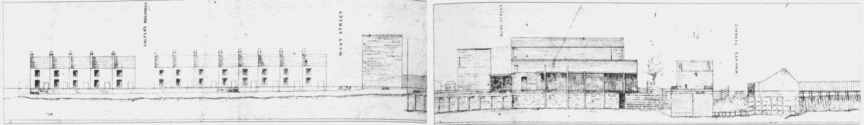
Sketch of part of the Bow Creek frontage on the west side of the Goodluck Hope peninsula in the 1880s, from Creekside (left) to Wright's Terrace. Demolished
Another short range of houses and shops was erected along the Orchard Place frontage between Lea Passage and Leamouth Place. This site, too, belonged to the FitzWigram estate, having been purchased by Sir Robert Wigram in 1815. (fn. 55) The southernmost premises of this group (No. 1 Orchard Place) was later occupied as a beer shop and public house under the name the Steam Packet. (fn. 56)
None of the houses or buildings mentioned here still survives, the majority having been demolished by the LCC in the later 1930s under slum clearance orders.
Another group of houses to disappear under a slum clearance order in the 1930s occupied an island site opposite the Orchard House. This, too, was a detached portion of the FitzWigram estate, which had been acquired by Sir Robert Wigram in 1815. It was developed in the mid-1840s with a row of five houses (Nos 46–50 Orchard Place) and the Trinity Arms, a large public house with its own adjoining garden. The Trinity Arms was erected under a lease of 1847 to the brewers Sir Henry Meux and Henry Smith. (fn. 57) One of the five houses was occupied as coffee rooms from the 1870s. (fn. 58) By the 1930s the public house had been unsuitably converted into tenement dwellings. (fn. 59) The site of these houses now lies mostly within the curtilage of Orchard Wharf. Close by, on land belonging to the Pemell Estate, was Ann's Place, a group of five houses built in the 1840s. These were four-room houses with wash-houses and small back yards. In 1870, after being repaired by the East and West India Dock Company, they were described as 'comfortable, well looked after, [and] occupied by respectable people'. (fn. 60) They were pulled down c1913.
Social Character
Few commentators on Orchard Place have used the word 'respectable' to describe any of its inhabitants. Writing mostly in the late nineteenth century or after, they all agree that this was a deprived area, inhabited by rough, very poor people, living in overcrowded conditions 'amidst the noise and odours of factories'. (fn. 61) Largely 'cut off from outside influences' by the 'peninsula character' of the area and the absence of any public transport, this was a closed and closely knit community, inward-looking and inbred, or as the LCC Education Officer politely put it, 'many families have the same rather uncommon names'. (fn. 62) Local amenities were restricted to a few basic shops, mostly clustered on the west side of Orchard Place, north and south of Leamouth Passage (Plate 112c), a school, and several public houses. There was no church, but by the early 1870s the local school was being used for religious services. (fn. 63) The Booth enquiry predictably deplored the presence of four public houses, and the fact that both men and women indulged, a practice attributed to the absence of any other form of entertainment. The manager of the local galvanized-iron works believed that the firm's football and cricket clubs had been of some value in 'giving the man an excuse to pass the public house without turning in'. (fn. 64) Though not mentioned by Booth, a sober alternative to the public house was available in the form of coffee rooms, which make their first appearance in Orchard Place in the 1870s.
The negative image of the district, which was described in The Religious Life of London (1904) as one of the 'black spots' of the East End, owes much to Booth's severely judgemental views of the district and its inhabitants. (fn. 65) Of the 50 or so families who lived in the small streets of houses opening off the west side of Orchard Place, only ten appeared to merit the description 'respectable', the rest being characterized as 'rough, poor, piratical and predatory'. The 'many bootless children, unwhitened steps, [and] no flowers in the front window etc etc' was evidence enough for Booth's investigators that these streets were amongst the 'poorest and roughest'. Overcrowding here was particularly bad, though the statement that '5 houses alone send 57 children to school' seems barely credible: possibly they were wrongly informed about this, as they were about the identity of the ground landlord. One of the causes of overcrowding was very early marriages, 'often at 16 or 17 and generally for very pressing reasons'. The 'rough' character of the inhabitants was said to have deterred local firms, such as Turner, Blewitt & Company, the oil merchants, and the Thames Iron Works, from employing local people, and most earned their living unloading barges and doing odd jobs, such as cleaning the boilers of small steamboats. (fn. 66)
One of those who contributed to Booth's enquiry said that 'the law as ordinarily understood hardly runs in Orchard Place and a policeman is very rarely seen'. The police themselves confirmed that they seldom visited the neighbourhood because it was 'a long way for us to come', but they claimed '[we] don't have much trouble here, people look rough but don't make much noise'. (fn. 67) An extraordinary and uncompromisingly harsh assessment of the inhabitants was given by a local clergyman, Father Lawless of the Presbytery in Upper North Street, who so far forgot his vocation as to call them 'hardly human' and 'incarnate mushrooms', adding that 'God must have made a mistake in creating them'. (fn. 68)
An important change in the character of the area occurred in the mid- to late 1930s as a consequence of the LCC's policy of slum clearance. The LCC had identified Orchard Place as 'one of the worst slums in London', (fn. 69) and most of the existing houses there were demolished. As the majority of families were found new accommodation away from Orchard Place, the district was virtually depopulated; some 300 people moved out of the area in 1936. (fn. 70) This naturally bore very heavily on the local shop-keepers and small business people, who saw their livelihoods disappear almost overnight when their premises were demolished. Although the LCC paid compensation and offered help with relocation, anyone with a river-based trade or business was particularly hard hit. One such case was that of the boatman and fisherman who lived at No. 1 Creekside and earned part of his living by catching shrimps, which he sold at his premises on Saturdays. The LCC offered help with finding an alternative mooring site, but conceded that he would have to move out of London altogether, perhaps as far as Southend. (fn. 71)