Survey of London: Volume 26, Lambeth: Southern Area. Originally published by London County Council, London, 1956.
This free content was digitised by double rekeying. All rights reserved.
'Vauxhall and South Lambeth: The freehold lands', in Survey of London: Volume 26, Lambeth: Southern Area, (London, 1956) pp. 66-73. British History Online https://www.british-history.ac.uk/survey-london/vol26/pp66-73 [accessed 25 April 2024]
In this section
THE FREEHOLD LANDS
Most of the freehold land in Vauxhall Manor was held at the beginning of the 17th century by Noel de Caron, Lord of Schoonewale in Flanders, one of the most distinguished inhabitants of Lambeth. In 1581 Caron was elected to the States General of the United Provinces, where he proved himself a devoted follower of the Prince of Orange. He was consequently chosen to be one of the envoys sent to England for the negotiations between the States General and Elizabeth I in 1585. From this time he appears to have become an enthusiastic anglophile and lived chiefly in England. After the death of their agent to the English Court, the States General elected Caron as his successor in 1591. (fn. 80) He was often referred to as “Sir” Noel de Caron, but this was probably a translation of his Flemish title as he does not seem to have been granted an English knighthood.
Caron purchased his property in South Lambeth in two parts. In 1602 he bought a “greate howse” with a dairy-house and about 70 acres, from Thomas Hewytt (Hewett) of St. Andrew Undershaft. (fn. 81) The property had been sold in 1586 by William Henbury and Morgan Pope to a William Hewett, whose sons had mortgaged it and conveyed the reversion to the Queen after the death of the mortgagees. The reversion was subsequently granted by Letters Patent to Caron, who held the property “as of the Manor of East Greenwich”, i.e. in socage. (fn. 82) In 1618 he added to his already considerable estate several pieces of land purchased from (Sir) William and Catherine Foster. (fn. 83) Catherine had inherited this property from her grandfather, Laurence Palmer, (fn. 84) who settled his estate on his son, Symon, and his heirs in 1592. (fn. 83) Caron also enjoyed the profits of the neighbouring Manor of Kennington. (fn. 85) He continued as ambassador until his death in December 1624, (fn. 86) and was buried in St. Mary's, Lambeth, in the following January. (fn. 87) The settlement of both his real and personal property took several years. His will (fn. 88) was imperfect and his kin began several lawsuits to recover his property. (fn. 89) The matter was referred to the Privy Council and in 1627 the Council politely informed the new ambassador of the States General that although all rights and privileges due to the quality of ambassador would be accorded to Caron's goods and estates, the lands he purchased in England were subject to the laws of the realm and that “none could inherite from an allien made dennizon (as Sir Noel Caron was) but the issue of his own boddy begotten”. (fn. 90) Caron had apparently never married and it was not until 1632 that the Privy Council was advised that it was “honourable and just” for the lands of Noel de Caron to be sold and the proceeds distributed amongst his kin. (fn. 91) The lands which he purchased from Hewytt were apparently divided and sold but the lands purchased from the Fosters were escheated to the Lords of the Manor of Vauxhall, and were subsequently known as “The Vauxhall Escheat”.
CARON HOUSE ESTATE
Perhaps on the site of the “greate howse” which he purchased from Hewytt, Caron erected a large mansion house (plot 30) which took several years to build. (fn. 92) Its grandeur may be judged from Plate 44a and from the little sketch which appears on the map of 1681, reproduced on Plate 123 of volume XXIII of the Survey of London. The large park which surrounded the mansion (fig. 19, plots 30, 31, 32 and part of 33) was well watered by Vauxhall Creek and studded with trees. During the Commonwealth period the house was owned and occupied by Alderman Francis Allen, (fn. 93) one of the Commissioners appointed to try Charles I, (fn. 94) and “a violent person against His Majesty”. (fn. 95) In 1666 the house and park were granted by the King to the Lord Chancellor, Edward, Earl of Clarendon, for a yearly rent of 10 shillings. (fn. 96) Clarendon sold the estate in April 1667 to Sir Jeremy Whichcott (Whichcote) of Hendon, (fn. 97) who had been Solicitor-General to the Prince Elector Palatine, (fn. 98) Charles Lewis, son of Frederick V. In the following September a patent was issued constituting the Fleet Prison to be at Caron House and granting the office of warden to Sir Jeremy. (fn. 99) He died in 1677 (fn. 100) and in that year his son, Sir Paul Whichcott, was said to be the owner of Caron House and park. (fn. 101) In 1683 the estate was leased by Sir Francis Pemberton, Benjamin Whichcott and Christopher Cratford of St. Giles in the Fields, to Thomas Grover, citizen and tallow-chandler of London, for one year at a peppercorn rent. (fn. 102) Sir Francis Pemberton was Lord Chief Justice of the King's Bench and had married Anne, the eldest daughter of Sir Jeremy; Benjamin Whichcott was Sir Jeremy's brother and Vice-Chancellor of Cambridge University until he was ejected at the Restoration. (fn. 103) Between 1683 and 1685 (fn. 104) Caron House was pulled down, but its name survived and during the 19th century two houses stood on the estate, one called Carroun House and the other Caron Place (see below). There is no proof that either of these stood on the site of the old Caron House.
The history of the estate can be traced from 1685 through deeds preserved at the Minet Public Library and at Lambeth Town Hall. In 1725 it was purchased by Edward Lovibond of St. James, Clerkenwell, and remained in the possession of his family until 1797, when it was sold to (Sir) Charles Blicke (fn. 35) who probably had Carroun House erected for his residence (see below). The plan of Blicke's estate reproduced here (fig. 24) is based on a plan of the estate drawn in 1838 and covers the area from Lawn Lane to the backs of houses in Heyford Avenue, and extends east to a line drawn from the rear of Vauxhall Park to the junction of Meadow and Fentiman Roads. From internal and external evidence there is no doubt that it describes the land granted to Clarendon in 1666 with the exception of a piece of Claylands (see page 60) and two small pieces of copyhold of Vauxhall Manor to which Blicke was admitted tenant in 1806 (see page 65) and 1808. (fn. 105)
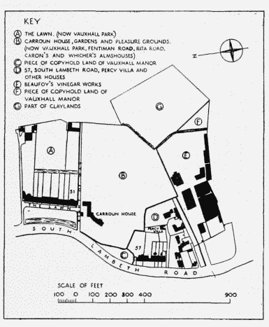
Plan of the estate of Sir Charks Blicke
Vauxhall Park
Fig. 19, plots 31, 32 and part of 33
The land marked A on fig. 24 was let on two leases in 1791 by George Lovibond to James Gubbins and Philip Buckley, together with the eight houses which they had erected. (fn. 25) These were Nos. 1–8 (consec.) The Lawn, so-called from the extensive grass plot which lay before them, later Nos. 37–51 (odd) South Lambeth Road. Henry Fawcett, M.P., the blind Postmaster-General, lived at No.51 from 1875 until his death in 1884. (fn. 106)
The large house shown on the land marked B on fig. 24 and called variously Carroun, Carron or Caron House, was occupied by Sir Charles Blicke. His heirs sold the house and grounds to William Evans in 1838 and it was subsequently occupied by John Cobeldick. (fn. 35) Fentiman Road was laid out on a line just south of the house in 1838, and the garden ground thus divided from the house by the road was sold by Evans to Henry Beaufoy. (fn. 107) Part of Rita Road now stands on this site. The part of the estate north of Fentiman Road which included The Lawn, and Carroun House and gardens, is now covered by Vauxhall Park.
A proposal was made in 1886 that roads should be formed across this part of the estate so that it could be developed for housing purposes, (fn. 108) but owing to the activity of Octavia Hill eight and a half acres were purchased for £43,500 from John Cobeldick by the Lambeth Vestry in 1889 for the formation of a park. (fn. 109) The purchase was made under powers granted by an Act of Parliament passed in 1888. (fn. 110) The London County Council and the Charity Commissioners contributed towards the purchase price, (fn. 111) and Mark Beaufoy, who was at that time M.P. for Kennington, also made a contribution. (fn. 112) The cost of forming the park was borne by the Kyrle Society whose landscape gardener, Fanny R. Wilkinson, designed the layout. (fn. 112) C. Harrison Townsend designed the entrance gates and railings. (fn. 35) The Society's Treasurer, Octavia Hill, was present at the opening ceremony on July 7, 1890, which was performed by Albert Edward, Prince of Wales. (fn. 113)
On the site of Henry Fawcett's house, which was pulled down for the formation of the park, stands an artificial stone statue to his memory (Plate 71b). It was modelled by George Tinworth and made at Doulton's manufactory, and was unveiled on June 7, 1893. (fn. 114) The statue stands on a pedestal which has panels representing Justice, Good and Bad News, Sympathy, Courage, Truth, India and the Post Office. The slightly raised terrace running northward from the statue follows the same line as the paved way in front of The Lawn.
Caron's Almshouses, Fentiman Road
Fig. 19, plot 33
In 1618 (fn. 115) Noel de Caron founded an almshouse on land belonging to him on the west side of the Kingston (now Wandsworth) Road (part of plot 7). The almshouse was a long, low, twostoreyed range (Plate 30a) containing seven separate apartments, and housed seven women aged over 60. In his will Caron stipulated that whoever occupied his house in South Lambeth should pay an annual rent of £28, from which a pension of twenty shillings was to be paid quarterly to each almswoman. (fn. 88) This proved an unsatisfactory arrangement, and in 1677 Sir Paul Whichcott, the owner of Caron House, was ordered by the Court of Chancery to pay the arrears which had accrued. (fn. 101) The charity was further endowed in 1773 by the Countess of Gower, in 1783 by Hayes Fortee and in 1867 under the will of Robert Forest. (fn. 101) The owner of Caron House, and later the owner of the site, continued to nominate the women for vacancies in the alms-house By 1853 the building had become “uncomfortable and unsuitable” for aged persons, and an offer of £1,500 was made for the site by Price's Patent Candle Company. (fn. 116) A petition was presented to the Court of Chancery and permission was granted for the Company to purchase the site on condition that the £1,500 was appropriated for the erection of new premises on a piece of land belonging to the Caron House estate then owned by William Evans. The new almshouses (Plate 30b) were erected on the north side of Fentiman Road in 1854. Under a scheme promulgated in 1893 the charities of the Countess of Gower, Hayes Fortee and Robert Forest were combined with Caron's and vested in the Official Trustee. (fn. 101) They are now administered under the United Charities of Lambeth Scheme (1924), and the almswomen are elected by the Trustees. (fn. 117) The site of the old almshouse, which measured about 105 by 47 feet, was sold to the Phoenix Gas Light and Coke Company in 1865, and is now incorporated with the works of the South-Eastern Gas Board. (fn. 116) The present almshouses are designed in Tudor style and built in a rich red brick with stone dressings. Tablets recording the benefactions of Caron and Evans, together with their coats of arms, are set in the gable over the centre house, which has a stone hood over its entrance.
Whicher's and Kifford's Almshouses, Stanley Close, Fentiman Road
Fig. 19, plot 33
These two almshouses were both founded in Westminster at the end of the 17th century, and were moved to Lambeth shortly after 1855. (fn. 35) By his will dated November 17, 1680, George Whicher left £1,500 for the purchase of land and the erection of an almshouse for six old men who were to be maintained from the residue of the money. The almsmen were to be nominated by Whicher's executors during their lives, and then by the Deans of Westminster and the Chapel Royal. (fn. 118) An almshouse was built in Little Chapel Street (now Caxton Street).
By her will dated December 30, 1698, Judith Kifford left £300 for the foundation of an almshouse for two “decayed virtuous poor gentlewomen” who were to be nominated by her executors and the survivor of them, and then by the executors of such survivor. (fn. 118) Two houses were erected in Brewer's Green in 1705, on land belonging to the Dean and Chapter of Westminster. The charity was abandoned by Mrs. Kifford's representatives and in 1824 an Order of the Court of Chancery appointed the Dean and Chapter as Trustees. (fn. 119)
By 1853 Whicher's almshouses were unfit for habitation and the Westminster Improvement Act (fn. 120) empowered the Dean and Chapter to sell both sets of almshouses to the Westminster Improvement Commissioners. The proceeds were to be applied to the purchase of a site and the erection of new houses which were to be conveyed to the Dean and Chapter, in accordance with a scheme to be sanctioned by the Court of Chancery. In 1855, William Evans sold a strip of land on the west side of Caron's almshouses to the Dean and Chapter; (fn. 35) two houses designed by Messrs. Hunt and Stephenson were erected there shortly afterwards, (fn. 119) one for each charity. They form a two-storey terrace designed in Tudor style. Their gables have ornamental wooden bargeboards with pendant finials.
Nos. 57 and 59 South Lambeth Road
Formerly Nos. 13 and 14 South Lambeth Road
Fig. 19, plot 30
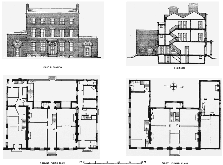
In 1768, when the Caron House estate was still owned by the Lovibond family, a lease of four and a quarter acres was granted to William Blackwell, a gardener, for 99 years. He was given licence to build on the land but also covenanted to maintain the garden ground in a “Husbandlike and Gardenerlike manner” and to keep about 200 standard fruit trees on the ground “in good heart” and to replace them as they decayed. This policy of making the best of both worlds led to the erection of Nos. 57–67 (odd), formerly Nos. 13–18 (consec.) South Lambeth Road, by William Burrows, plasterer, who had a sub-lease from Blackwell. (fn. 35) No. 57 is a plain stock brick terrace house of three storeys with an attic (fig. 25). The doorway has a patterned fanlight and there are keystones with modelled heads, probably in Coade's artificial stone, over the ground-floor round-headed arches (Plate 70a, 70b, 70c). The front of No. 59, a three-storey house with a narrower frontage, has no ornament. The carcase of the adjoining building (formerly part of No.59) remains, though it has been refronted in recent years. Nos. 61–67 have been demolished. Most of the site marked D on fig. 24 is now occupied by William Bloore and son, Ltd., timber merchants. The firm has occupied No. 57 South Lambeth Road since 1879, (fn. 121) but was established earlier in Bond Street (fn. 122) (now Bondway). The house marked Percy Villa on fig. 24 and now pulled down was the home of Lionel and Mary Brough, (fn. 122) the famous actor and actress.
No. 87 South Lambeth Road
Fig. 19, plot 30
The land marked E on fig. 24 is the site of Beaufoy's Vinegar Works. These formerly occupied a site on the south bank of the Thames which was needed for the formation of Waterloo Bridge. (fn. 123) In 1810 John Hanbury Beaufoy bought four acres of land from Sir Charles Blicke (fn. 35) and built a new manufactory and family residence (Caron Place) on the site (Plate 42); the architect is not known. The buildings have a distinguished quality which compares favourably with the later industrial buildings near by. The manufactory and offices are housed in substantial buildings of two and three storeys, built in stock brick with stone dressings, and grouped about a long yard. This yard was approached thorugh a walled garden along a short private road, at the inner end of which stood two single-storey lodges. The south lodge was destroyed by bombing on October 12, 1940, but the surviving north lodge has a loggia with cast-iron columns, surmounted by the arms of the Beaufoy family. The iron gates illustrated on Plate 42a were removed from the Royal Exchange after the fire of 1838; (fn. 124) they are now preserved at the Beaufoy family's present home at Heyford in Oxfordshire. On the south side of the yard stands Caron Place, a plain building formerly inhabited by the Beaufoys, and now used as offices. Alongside is the shell of a two-storey building burnt out in an air-raid on May 10, 1941. The first floor of this building was formerly used as a ballroom, which was lit by stone-dressed Venetian windows on the north and east sides. The stock brick elevations are finished with a triglyphed frieze beneath a stone cornice and blocking course. The dominant building in the group is the vat house, which stands at the east end of the yard. It is surmounted by a wooden cupola which is raised above a wooden rusticated stage containing a clock. Before a fire damaged the building in 1916 the copper-covered cupola was supported by a solid square stage, pilastered at the corners, instead of by the present eight free-standing columns. The bell hanging in the cupola is cast with the inscription. “THOMAS MEARS LONDON FOUNDER 1843”. Another bell preserved on the premises but not hung is inscribed “HENRY BEAUFOY ESQ., 1833”. The floor of the cooperage behind the yard is paved with mill stones formerly used in the manufactory. The premises are now owned by British Vinegars Ltd., and are used for blending, bottling and cooperage work.
THE BOND ESTATE
The history and disposition of the remainder of the freehold lands which Noel de Caron purchased from Thomas Hewytt are not so easily traced, but it is possible to sketch their descent by means of the evidence of field names in a few surviving deeds. An idea of their disposition may be gained from the fact that the Bond estate, with which they nearly coincided, included plots 11, 12, 14, 20, 24 and part of 22 (fig. 19).

No. 57 South Lambeth Road. Lessee, William Burrows, Plasterer
When Thomas Hill drew his map of Vauxhall Manor in 1681 most of this property was owned by John Plumer and William Freeman. Plumer sold 20 acres to Elias Ashmole in 1686 (fn. 125) and Thomas Cooper purchased Freeman's lands in 1683. (fn. 126) Both estates became vested in Cooper's great grand-daughter Emma Miles (fn. 127) and in 1766 she sold them to John Bond of Crutched Friars, merchant, and Sarah his wife, (fn. 128) who were responsible for their development. In 1778 they obtained a building Act (fn. 128) and let the ground in small plots and the present Bondway, Miles Street, Parry Street and Wyvil Road were laid out to form a neat residential area. The houses erected under the building leases were provided with long gardens (fn. 129) and a proprietary chapel (now St. Anne's Church) was erected to meet the spiritual needs of the increased population. The subsequent incursions of the London and South Western Railway Company have completely altered the character of the neighbourhood.
St. Anne's Church, South Lambeth Road
Fig. 19, plot 12
This church stands on the site of South Lambeth Chapel which was built in 1793 (Plate 13c). On January 9 of that year John and Sarah Bond granted a lease for 99 years of land fronting South Lambeth Road to certain local inhabitants, for the erection of a proprietary chapel. (fn. 130) The committee appointed to supervise its erection included John Dollond, the optician, Philip Buckley, James Gubbins and Sir Charles Blicke, who all had interests in the development of the vicinity. (fn. 131) The members of the committee decided to limit the cost of the chapel to £3,000, including the furniture and ornaments, and this sum was to be raised by issuing 60 shares at £50 each. Each share entitled the holder to four seats. Seats not allocated in this way (there was accommodation for about 600 persons and no seats were free) were let only to persons approved by the proprietors. For the governing of the chapel's affairs a committee of six was elected. The minister was chosen by the rector of St. Mary's, Lambeth, but his salary of £40 a year was paid by the proprietors. (fn. 130)
After the building of the Nine Elms railway terminus and the works of the Phoenix Gas Company, most of the wealthy proprietors moved away from the district and the prosperity of the chapel declined. (fn. 132) The building was badly damaged by fire in 1856 (fn. 133) and the committee tried to persuade the Ecclesiastical Commissioners to persuade the Ecclesiastical Commissioners to purchase the building for a parish church. (fn. 132) The Commissioners eventually bought the freehold interest of the chapel, and the building was consecrated as St. Anne's Church on February 3, 1869, (fn. 134) on the understanding that it would soon be altered and enlarged. The present church (Plate 13d) was erected in 1876 to the designs of R. Parkinson (fn. 135) and consecrated in the same year on December 19. (fn. 134) It was built in quasi-Romanesque style, in stock brick diapered with red brick, and with stone dressings. The body of the church is plain, with an apse at the east end. At the north-east corner stands an unfinished tower with a semi-circular stair projection. The entrance is at the base of the tower on the Miles Street frontage. As a result of war damage in 1941 the church has not been used for some years, but it is hoped that restoration will begin in 1956.
Wyvil Primary School, Wyvil Road
Fig. 19, plot 14
This school was built by the London School Board and opened on January 8, 1877. The architect was E. R. Robson. The contractors were Hill, Higgs, and Hill of South Lambeth Road, and their tender for a school for 828 children was for £7,782. (fn. 136) The building has been remodelled and extended. It has three storeys and is built of stock brick; the north and south elevations are symmetrically arranged and finished with gables, those on the south being flanked by short towers.
Tate Free Libary, South Lambeth Road
Fig. 19, plot 16
This building and its site were provided by (Sir) Henry Tate at a total cost of nearly £6,000. The architect was Sidney R. J. Smith, and the builder B. E. Nightingale. The library was opened by A. J. Mundella, M.P., in 1888. (fn. 137) It occupies a three-storey building built of red brick with Portland stone dressings, and is sited with its principal axis equiangular with Wilcox Road and South Lambeth Road. The semicircular projecting porch at the road junction is supported by caryatides and telemones. A pedimented bay sets forward over the entrance and is flanked by two short towers each with a lantern termination. The building has single-storey wings and all the roofs are slated.
No. 274 South Lambeth Road, 1791–2. Lessee, William Burrows, Plasterer
Nos. 268–274 (Even) South Lambeth Road
Formerly Nos. 248–254 (even) South Lambeth Road
Fig. 19, plot 22
In 1791 Crooked Bridge Field was let by John and Sarah Bond on building lease to William Burrows of South Lambeth, plasterer, (fn. 138) who erected these houses on the site. No. 274, Beulah House, is a well-proportioned three-storey house with single-storey wings (fig. 26). The wings and central Ionic porch have been altered or rebuilt sympathetically. The modelled keystones to the arches in the wings are almost certainly of Coade's artificial stone (Plate 70d and 70f); they are very similar to the keystones on Nos. 362–366 Kennington Road. The house was first leased in 1798 to Horatio Clagett. (fn. 138) From 1825 until his death in 1849 (fn. 78) it was occupied by John Poynder, clerk and solicitor to Bridewell Hospital. He was the author of several theological tracts and “Literary Extracts from English and other Works, collected during Half a Century”. He was also a stock-holder in the East India Company, and as a result of his passionate campaigning the practice of suttee was in 1829 declared to be punishable as culpable homicide. (fn. 103) In 1852 a lease of the house and premises, including a wash-house, laundry and drying ground in the rear, was obtained by Thomas Cook, William Hill and Henry M. Rogers, “scourers”. (fn. 138) The premises are still used by Rogers and Cook, Ltd.
Stockwell Baptist Church, South Lambeth Road
Fig. 19, plot 22
This church with its ancillary buildings also stands on part of Crooked Bridge Field. (fn. 139) It was founded and erected in 1866 by James Stiff, the pottery manufacturer, who had a factory in High Street, Lambeth. (fn. 140) The church is built of yellow stock brick and has an ill-proportioned front composed of a deep tetrastyle Corinthian portico with flanking pavilions pilastered at the corners. A dentilled pediment surmounts the portico, and the entablature is carried in a simplified form across the pavilions. The portico has a cement finish.