Survey of London: Volume 27, Spitalfields and Mile End New Town. Originally published by London County Council, London, 1957.
This free content was digitised by double rekeying. All rights reserved.
'Spitalfields Market area', in Survey of London: Volume 27, Spitalfields and Mile End New Town, (London, 1957) pp. 127-147. British History Online https://www.british-history.ac.uk/survey-london/vol27/pp127-147 [accessed 11 April 2024]
In this section
CHAPTER XI - Spitalfields Market Area
Spitalfields Market
Th e present site of the market includes the area occupied in about 1680 by the roughly rectangular space known as Spital Field or Spital Square, (fn. n1) bounded by Lamb Street, Crispin Street, Paternoster Row (the present eastern end of Brush field Street, also referred to as Great Paternoster Row or Street) and Red Lion Street (the line of which is now represented approximately by Commercial Street). Until its westward extension in the 1920's the market buildings were limited to this rectangle. The site now includes the ground formerly occupied by the northern part of Crispin Street, and also the north-eastern part of the former Old Artillery Ground, including the northern parts of Gun Street and Fort Street (fig. 32).
In March 1648/9all that open field called Spittlefield was included in the part of Spittlehope or Lolesworth field, lying south of the line of Brown's Lane (Hanbury Street), that was conveyed to trustees by William Wheler of Datchet in trust for himself and his wife for life and then for his seven daughters. (fn. 1) At that time the field extended further south and west than is shown on Ogilby and Morgan's maps of 1677 and 16812. The eastern side was perhaps already bounded by the eastern side of Red Lion Street, and the northern boundary, formed by the northern side of the later Lamb Street, was perhaps also partly built-up at that time. On its western side the field was reduced in size when Crispin Street was built in 166870 (see page 136) and on its southern side when Paternoster Row and Datchett or Dorset (now Duval) Street were built, probably in the 1670's (see below).
Until the building of these streets on the western and southern sides there were probably no roadways made up and fenced before the houses fronting the field, except perhaps on the eastern side. In the 1660's and early 1670's the field, which was apparently used for grazing cattle (see page 190 & n.), was traversed by footpaths from Lolesworth, or Brown's Lane (Hanbury Street), Vine Court (formerly on the north side of Lamb Street), theRed Lion and the George to Smock Alley (Artillery Passage). (fn. 2) It was also traversed by a footpath forming the direct way to Stepney church. (fn. 3)
The reduction of Spital Field to the area it occupied when the market-franchise was granted in 1682 was probably completed between 1672 and 1677 by building on its southern side and the enclosure of the field to leave passageways only along the streets bounding its four sides.
The southern part of the field, later occupied by Paternoster Row, Datchett or Dorset Street and White's Row (marked as New Fashion Street on Ogilby and Morgan's map of 1677) is shown to be still open in 1667 on Hollar's plan of London after the Great Fire. In June 1672 Edward Nicholas and George Cooke, the two acting trustees under the deed of March 1648/9, petitioned the Privy Council, on behalf of the seven daughters, for permission to build on what was evidently this part of their property, which they said lyes very comodious for more Buildings to be erected whereon some Foundations are already laid and neere finished and which was a noysome place and offensive to the Inhabitants through its Low Situation till by the Petitioners great charge it was filled up and Levelled, there being also a large Space of Ground that will be left unbuilt for ayre and sweetnes to the place (fn. 4) In August the Lord Mayor and Sir Christopher Wren, though expressing apprehension at the great eastward extension of London, reported that the proposed building would be no great addition to what was already built there and that the Feild will remaine Square and open and the wettnesse of the lower parts be remedied. (fn. 5) In November Nicholas and Cooke were granted permission to build. (fn. 6) In this and the following year they issued eighty-year building leases of sites on the northern and southern sides of Datchett or Dorset Street and on the northern side of White's Row to a number of lessees including Nicholas Poulton of St. Catherine Cree, bricklayer; Robert Deves of Stepney, plasterer; Josias Hill, Christopher Dome, and Anthony Collett, all of Stepney, carpenters; Richard Lamson of St. Botolph Bishopsgate, carpenter; Thomas Hodges and Thomas Poole, both citizens and joiners of London; Mathias Smith, citizen and glazier of London; and John Gooding, citizen, tyler and bricklayer of London. (fn. 7) The houses were not large, most of them having a frontage of about sixteen feet. Not all the building was well or quickly executed. In November 1675 a search by the Tylers and Bricklayers Company resulted in fines being imposed on a Mr. Martin and aMr. Greene for the use of badd and black mortar in this street. (fn. 8)
Two other builders were fined at the same time on account of black mortar and work not jointed and bad mortar and bad bricks in Spittle feilds. (fn. 8) This was perhaps in Paternoster Row, which was probably built at the same time. It appears fully built-up on Ogilby and Morgan's map of 1677, and the form of the licence to build in 1672 suggests that the building would adjoin the open field, and thus probably included Paternoster Row.
In July 1673 Nicholas and Cooke were given permission to close the foot-paths running across Spital Field, provided they replaced them with a road about 400 feet long and 24 feet wide. (fn. 2) Subsequent disputes make it clear that this street was Datchett Street, which is of the stated dimensions: it can, however, have provided only an imperfect substitute for a path from Vine Court to Smock Alley. By May 1675 Spital Field was railed in. (fn. 9) On the map of 1677 the field is shown enclosed, perhaps by small trees.
It appears from a complaint made to the Privy Council and a report submitted by Wren in 1675 that the building operations at this time included the unlicensed erection of houses on the north side of the street now called White's Row (see page 144)
In the meantime the area of Spital Field itself had been leased in December 1672 by Nicholas and Cooke to John Balch and Henry Allen (fn. n2) for eighty years, in trust for Balch. (fn. 11) This lease contained a restriction on building, which was lifted by a Chancery decree, probably of February 1683/4. (fn. 3) It was to Balch that the right to hold a market on the site was granted, ten years after this lease. He was a silk thrower, probablv of Somersetshire origin, who in 1679 married Katherine Wheler, the daughter to whom the seventh schedule of her father's property fell at the partition in 1675 (see page 97). In his will of October 1682 Balch, who is there described as of Stepney, esquire, speaks of Edward Nicholas as his cousin, and this may account for his having obtained the lease of Spital Field. The will also speaks of my now dwelling house in Spittle Fields and the other houses thereunto adjacent which I doe hold by Lease, out of the rents of which he left an annuity of 40 to his mother. It is not known where these were. Balch evidently carried on a considerable, if insolvent, silk thrower's establishment, apparently in partnership with Captain Edward Metcalfe. His will mentioned an engine for the mechanical winding of silk patented by Dr. Joachim Becker, the patent for which Becker had assigned to him. Metcalfe enjoyed a moiety of the profits of this for seven years, and was bequeathed a further seven years' interest in the moiety by Balch. His will also referred to apprentices bound to him and Metcalfe by the Company of Silk Throwers and by several parishes. His political sentiments are revealed by his bequest to the hamlet of Spitalfields of those four roomes or almeshouses which I lately erected in the Teynter feilds, probably on a site now occupied by Christ Church Spitalfields churchyard, provided that the hamlet accommodated there only such as have alwayes beene and shall bee Conformable to the Government both in Church and State as it is now established by Law. (fn. 12)
In 1675 Nicholas and Cooke transferred their interest in the Wheler estate to further trustees when it was decided to partition the daughters' inheritance. In this partition the open field of Spital Field was, like Joyce's Garden, excluded, and held by the daughters in undivided shares.
In 1682 the Crown was selling its Old Artillery Ground property, adjoining Spital Field, and evidently hoped to be able to benefit from the eastward growth of London by granting, for a consideration, the right to hold a market there (see page 29). This plan fell through, perhaps because of opposition from the City, but in the same year the Crown granted the right to hold a market in Spital Field (fn. c1) On 29 July 1682 John Balch, esquire, was granted the right to hold two markets each week, on Thursdays and Saturdays, in or next to (in sive juxta) a certain place calledle Spittle Square in Stepney, with all the profits and tolls arising out of it. (fn. 13) By Spittle Square the rectangle of Spital Field was meant.
Balch had by then acquired a seventh-share in the freehold of Spital Field by his marriage three years before to Katherine Wheler. (fn. 14) In May 1682, shortly before the grant of the market-franchise, he had also acquired the shares of three other of the six daughters then surviving, Frances Wheler, spinster; Anne Pitcarne, widow; and Mary, the wife of Martin Vandenancker. (fn. 15) The description and dimensions of the property of which shares were thus conveyed indicate that it included only the enclosed field and not the four surrounding streets.
Thus by October 1682 when Balch made his will he was possessed of two-thirds of the freehold interest as well as of all the leasehold interest in Spital Field or the market site, and of the marketfranchise. All this he left to his daughter Elizabeth, with the proviso that if she died before the age of twenty-one it should go to his good Friend Edward Metcalfe, who, together with Elizabeth, was appointed joint executor of his will, which was proved by Metcalfe in February 1682/3. At the time of making his will the leasehold interest was vested in Paul Priaulx, Balch's loving friend, in trust for him. (fn. 12)
Building development on the market site was begun by Edward Metcalfe, who also built the market-house. The first building probably took place in 1684. (fn. n3) In September of that year Metcalfe assigned to Richard Shelley of the Middle Temple, gentleman, as a mortgage to secure 700, the residue of Balch's eighty-year lease of 1672, in respect of a part of the field measuring fifty-seven feet by thirty-seven feet. It was said in a Chancery petition later brought by Shelley that the market area was by September 1684 allotted and sett out and the ground thereof raised for a Market place.It was also said that Metcalfe had already erected and built thereupon a Markett house and diverse shopps and stalls for the necessary use of the said Markett and had then already paved the greatest part thereof and was preparing to pave the rest and erect diverse other shopps and shedds and stalls thereupon. Shelley stated that the mortgage expressly included the profits of the market. (fn. 17)
From Shelley's petition it appears that Balch had died in debt and that a Chancery decree, probably of February 1683/4, (fn. 18) had made the whole area of Spital Field leased to him in 1672 liable for the payment of his debts: it had also evidently ordered Priaulx to convey his leasehold interest to Metcalfe. The latter was said to have come to an agreement with the owners of the outstanding shares in the freehold of the market to allow him to build. (fn. 17)
In the autumn of 1684 and during 1685 Metcalfe granted building leases in Spital Field, apparently for sixty-one years: these leases were on the north, south and west sides but probably not on the east side. The builders taking leases from Metcalfe included John Cooper, glazier; (fn. 19) John Hay wood, tyler and bricklayer; (fn. 20) Daniel Butler, carpenter, (fn. 21) and William Parker, tyler and bricklayer, (fn. 22) who was probably active in the Old Artillery Ground and Artillery Passage and who built houses (see Plate 51a) on the southern side of the market-place, in South Street and on the northern side of Paternoster Row (later Brushfield Street). In 1684 there was a Burton's Row in South Street, probably named after a builder, (fn. 23) and in March 1685 a Ralph Hard wick, of unspecified trade, took a building lease and built ten houses on the north side of the market. (fn. 24)
The lay-out established by Metcalfe was symmetrical, with a cruciform market-house, surrounded by stalls, in the centre and four Lshaped blocks of buildings around it, each containing houses facing inward on to the central market-place and other houses facing outward on to the four streets surrounding the former Spital Field. The four blocks, each of which contained a court-yard with access to the marketplace, occupied the corners of the square and were separated by four streets, North, South, East and West Streets, which linked the central market-place to the surrounding streets (fig. 32).
The external appearance of the market-house is represented by the ornamental head of the silver staff belonging to the churchwardens of Christ Church,(see fig. 33). It was a cruciform building of one storey with an attic, each of the four equal arms having plain windowless sides and a frontal portico, tetrastyle and, presumably, Doric. The steeply pitched roof swept out over an eaves cornice, and each hipped end contained a casement dormer. Over the crossing rose a square turret with a clock-dial on each face and a domed roof.
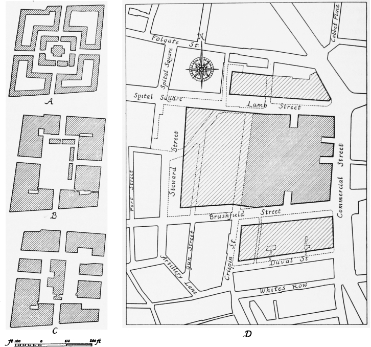
Plans showing the development of Spitalfields Market. Original area heavily shaded A. 1703, from Gascoine's map B. 1746, from Roecquemap C.1873 and D. 1938 from the Ordance Survey maps
In February 1685/6, when Shelley submitted his Chancery petition, he claimed that the 700 lent to Metcalfe had not been repaid, and thai the assignment had become absolute. But Metcalfe claimed that the validity of his mortgage had been challenged by Balch's creditors who asserted that the money lent to him by Shelley had not been applied, as it should have been, to the discharging of their debts. Shelley was thus concerned to argue that his 700 had been properly applied by Metcalfe towards the betterment of Balch's estate- He claimed that Metcalfe was himself a creditor of Balch. He further argued that Metcalfe's building activities had improved the site which had been valueless,to be worth many thousand of pounds in all which matters the said Edward Metcalfe did expend above Two thousand pounds.
Metcalfe was also said by Shelley to have threatenedto remove the said Markett from of the said mortgaged premises to some other place although after the building of the surrounding blocks of houses this can hardly have been practicable within the area of the squarersquo;, and the removal of the market to Batch's former property in the adjacent tenter ground would probably have been difficult to reconcile with the terms of the grant.
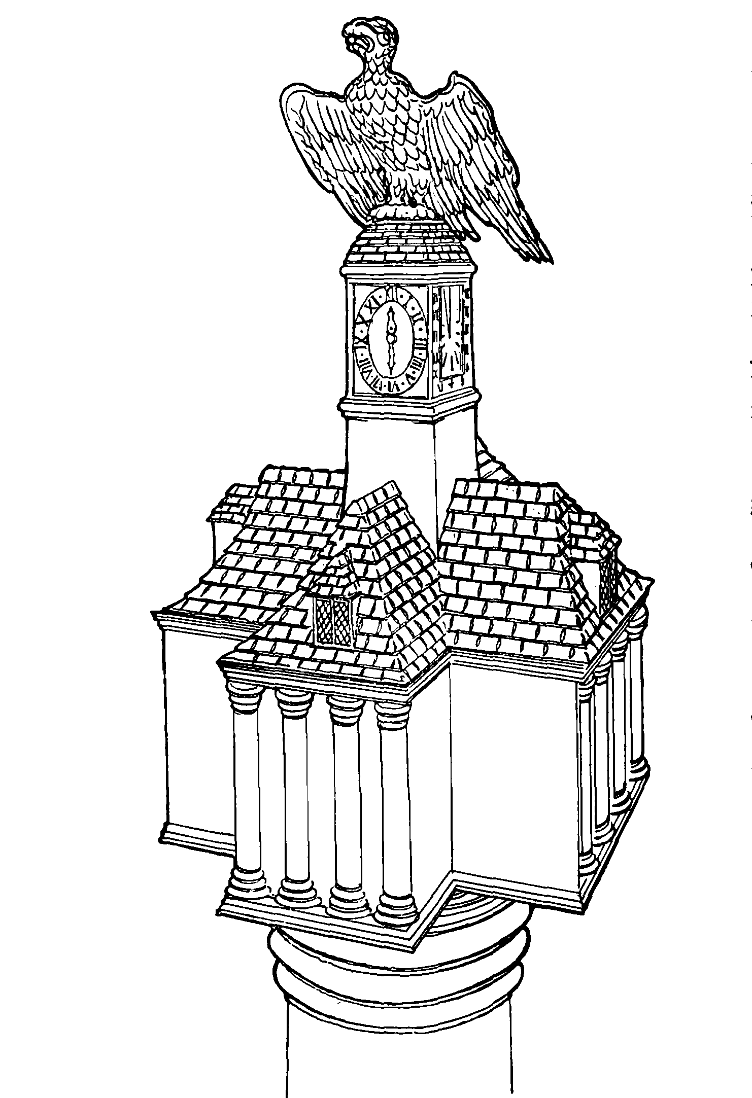
Spitalfields Market-house, 1684, as represented by the head of the churchwardens' staff, Christ Church
In his reply Metcalfe acknowledged the truth of the substance of Shelley's petition, and asked to be allowed time to sell the market estate and redeem the mortgage, the debts owed by Balch being greater than the said estate to be sold'. (fn. 17)
The result of the petition is not known, but by March 1687/8 further building leases, for sixty-two years, were being granted, apparently on the east side of the market and in Red Lion Street, by William Millett or Mellett, a trustee of the creditors of Balch and Metcalfe. He granted leases to George Hatton, bricklayer, and Thomas Oade, citizen and blacksmith: William Smith, plumber, was also probably a lessee at this time. (fn. 25)
By July 1688 the leasehold interest and marketfranchise formerly possessed by Balch had been purchased by George Bohun (or Boun), described as merchant or esquire of London, and later of Newhouse, Coventry, who in the following year gave a fire-engine to the hamlet (fn. 26) and later played a part in Sir George Wheler's disputes with the congregation attending his chapel. (fn. n4) Between July 1688 and August 1689 Bohun granted further building leases, mainly on the east side of the market and in Red Lion Street, some to Oade and Parker, (fn. 27) and some to Henry Taber and John Peck, carpenters. (fn. 28) In September 1688 he was granted, as George Boun of the City of London, merchant, letters patent which, in consideration of his acquisition of Balch's leasehold interest and for the greater advantage easement and convenience of our people inhabiting and residing in and near the place aforesaid, confirmed to Bohun the right granted to Balch to hold a market on Saturdays and also allowed him to hold a market on Mondays and Wednesdays instead of on Thursdays. (fn. 29) This second patent was evidently regarded in the eighteenth century as the foundation of title to the market-franchise, but was subsequently judged to have been rendered ineffective by the Act of 1690 which annulled all grants relating to the City of London made since Trinity term 1683. (fn. 30) Bohun had, however, a right to Balch's interest in the first grant.
In 1693 Bohun acquired one of the two outstanding shares in the freehold not forming part of Balch's interest. (fn. 31) Later, in August 1708, he came to an agreement with Charles Wood and Simon Michell, who had acquired the interest of Balch's heirs in two-thirds of the freehold of the market, for the conveyance to him of one half of this interest: Wood and Michell also undertook to secure the conveyance to him of the other half of this interest which had descended to Elizabeth Moore, later Elizabeth Hopkins (fn. 32) (see page 181).
The other outstanding share had been conveyed in 1696, for 1,000, by James and Wheeler Whitehall, and the latter's wife, Jane, to trustees for John Bigge of the Middle Temple, gentleman. (fn. 18) This one-sixth share of the freehold, which carried with it no interest in the market franchise, remained the property of Bigge's descendants until the 1830's.
The subsequent history of the freehold may be briefly indicated. By his will of July 1705, proved in 1710, Bohun, then described as of Newhouse, Coventry, esquire, left his Spital fields estate to trustees for three daughters, Mary who married Rowland Berkeley, Elizabeth who married Packington Tomkyns, and Jane who married firstly George Lucy and secondly the Hon. Robert Moore. (fn. 33) In 1732 the outstanding moiety of John Balch's interest in the freehold, which had descended to Elizabeth Hopkins and which Wood and Michell had undertaken in 1708 to have conveyed to Bohun, was conveyed by Elizabeth and her husband to a trustee for Simon Michell, and in 1738 was conveyed by Michell and others for 2,000 to trustees for Berkeley, Tomkyns and Moore, in compliance with an order of the House of Lords made in 1737. (fn. 34) By 1741 the whole interest in this five-sixth share of the freehold and in the market-franchise, which derived from Bohun, had apparently become vested in Moore, (fn. 35) who was sometimes described as of Enfield Chase. In 1787 this share was sold by representatives of Moore's interest, for 27,000, to Edward Russell Howe of Gower Street, Bedford Square, esquire, and James Sibbald of Upper Harley Street, esquire. (fn. 36) In 1829 devisees under Howe's will sold his moiety of the franchise and of this share of the freehold to Isaac Lyon Goldsmid, the financier and philanthropist who had previously occupied No. 20 Spital Square. (fn. 37) In 1834 Goldsmid also purchased from C. W. Bigge and J. Hanson for 5,000 the outstanding one-sixth share which had been acquired in 1696 by John Bigge. (fn. 38) The Goldsmid family acquired a further quarter of Howe and Sibbald's five-sixth share in 1873 when Sir Julian Goldsmid purchased it for 13,500 from Sir James Sibbald David Scott. (fn. 39) It is not clear when the remaining quarter of this five-sixth share was acquired by the Goldsmids. In May 1902 the whole freehold was purchased from F. D. Mocatta and others, representing the Goldsmid interest, by the Corporation of London, for 176,750. (fn. 40)
After Bohun's death the market apparently continued in the occupation of his widow as the rate books for 1716 and 1724 include assessments of Madam Bohun for the Markett at 80 and 100 respectively. (fn. 41) At this time the market was used for the sale of meat as well as of vegetables. Hatton in 1708 speaks of it as a fine Market for Flesh, Fowl and Roots, (fn. 42) and Defoe in about 1725 includes it among flesh-markets. (fn. 43)
The market-house built in 1684 is shown on Gascoine's map of 1703, on the Norton Folgate New Church plans of 1711, in Strype's 1720 edition of Stow, and on the plan attached to the assignment of Christ Church parish made in January 1724/5 which was, however, probably copied from Gascoine. (fn. 44) By 1732 it was described as having been consumed a few years since by Fire. (fn. 45) In 1700 and 1719 its upper storey was probably occupied as a meeting-house by the congregation of French Protestants who in the latter year built Brown's Lane chapel. Their move to Brown's Lane may indicate the time of the market-house fire. (fn. 46) It was not rebuilt. Stalls had by 1732 been built round the market-square and in the middle are sold Greens, Roots, etc. (fn. 45) The market buildings remained of wood until the 1880's.
In December 1741 Robert Moore, in whom the Bohun freehold and leasehold interests were vested, petitioned the Treasury for a new grant altering the market days allowed by James II's patent to Bohun, which Moore apparently regarded, despite the Act of 1690 (see above), as the foundation of the market-franchise. Since the demolition of the Stocks Market a year or two previously the gardeners and farmers brought their fruit, roots and herbs to the Spitalfields market, but wished to retain Tuesday and Thursday as market days, in addition to Saturday, as at the Stocks Market, instead of Monday and Wednesday as in Bohun's patent. Moore said he intended to pave the market-place and make provision of stands for wagons and carts. (fn. 35) An inquisition ad quod damnum approved a new grant of a right to hold a fruit and vegetable market, but not a flesh market, on Tuesdays and Thursdays. No grant appears to have been made. (fn. 30) In the nineteenth century, however, Tuesday and Thursday, not Monday and Wednesday, were, with Saturday, customarily regarded as the market days. (fn. 30) Leases granted by Moore and others in 17446 suggest that, despite the decision not to grant a flesh-market, many of the occupants of the market premises at that time were butchers. (fn. 47)
Some indication of the valuation put on the market at this time is given by the mortgage of the market-franchise and the five-sixth share of the freehold together with an annuity of 40 in lieu of the outstanding one-sixth share, to secure 11,550 in 1743/4. (fn. 48)
In the same year William Bigge leased, in consideration of 800, his one-sixth share to a trustee for Robert Moore for eighty years from the expiry in 1752 of the 1672 lease, thus securing to Moore effective occupation of the whole for a long term of years. (fn. 49)
In the later nineteenth century the extent of the market and the right of the owner of the franchise and his lessees to occupy the surrounding streets with stalls and carts was hotly disputed. In 1746 a lease granted by Robert Moore to a shopkeeper of a house in North Street reserved to Moore the right to set carts in the street before the house on market days for the sale of fruit and vegetables. (fn. 50) North, South, East and West Streets were undoubtedly included in the area of the freehold market property and equally obviously access to the central market-place through these four streets, which, like the market-place, were rated by the Commissioners of Sewers, was open and public. In the Act of 1772 for the paving, cleansing, lighting and watching of the parish (fn. 51) the Commissioners thereby appointed were empowered to pave North, South, East and West Streets, as well as the four surrounding streets, but not explicitly to pave the central market-place. Provision was also made for penalising the obstruction of the paved streets with carts. In 1788 the Act to explain and amend the 1772 Act prescribed penalties for selling Wood, Coals, Roots, Greens, Fruit, Fish, Flesh, Fowl, House-hold or other Goods, in the streets paved by the Commissioners and for obstructing the roadways or pavements with benches or stalls, and for leaving carts standing in the streets. (fn. 52) There was no specific exception in regard to the streets leading to the market-place. There was, however, a proviso that agreements between landlord and tenant should be unaffected, disputes between them being determined by the Commissioners. (fn. 53) This may have been interpreted to mean that the market owner retained, and could transfer to lessees, the right to sell from carts in the approach-streets which Moore had reserved to himself in 1746. In 1884 a judgement of the Court of Appeal decided that the right to hold a market in the streets around the market-place was not affected by these Acts. They were judged to have been intended merely to prevent nuisances and not to diminish existing rights. (fn. 54)
In 1770 the market was said to be of great reputation for all sorts of provisions. (fn. 55)
It was probably in the late eighteenth century that the market-franchise and leasehold interest were first held separately from the freehold interests. In September 1787 Howe and Sibbald, following their purchase of the market-franchise and five-sixths of the freehold, leased all their interest for ninety-nine years to William Town shend and Samuel Winmill, merchants, who had premises on the northern and southern sides of Paternoster Row respectively (fn. 56) (see Plate 25a). It was said to be granted in consideration of a total yearly rent of 1,870 and the expenditure by the lessees of 5,000 in repairing the premises within the next twenty-one years. (fn. 57) A comparison of Rocque's maps with Horwood's of 1799 and nineteenth-century maps suggests that in addition to the possible erection of larger and more regularly disposed stalls in the central marketplace there may have been some reconstruction to give better access to the market from Red Lion Street by widening a passage in the south-eastern corner of the market-place, south of East Street.
Until the late eighteenth century communication between the market and Bishopsgate Street and Whitechapel was very defective. Access to Bishopsgate was improved by the construction of Union Street (now the western part of Brushfield Street) from the western end of Paternoster Row to Bishopsgate Street under Acts of 1778 and 1782 (see page 141).
In 1803 the market was assessed for rates as a Potatoe and Fruit Market. (fn. 41)
By March 1827 Townshend and Winmill's leasehold tenure had for some time been possessed by John Hanson of Upper Norton Street, Mary lebone, a solicitor. (fn. 58)
Further improvement in the communication from the market was foreshadowed in 1838 when the southern part of Commercial Street, running from Whitechapel to Spitalfields Church, was projected. In that year a witness before the Select Committee on Metropolitan Improvements wanted the proposed street to be extended northward to Shoreditch High Street and so relieve the immediate neighbourhood of Spitalfields Market where there is a very great number of vehicles in every market day, three times a week. (fn. 59) In 1845 the rector of Christ Church, giving evidence before the Commissioners for Metropolitan Improvements, argued that a street coming only as far north as the church would bring more traffic than the existing outlets into Bishopsgate Street past the market site would be capable of carrying. Of the former Paternoster Row he observed: there is no thoroughfare in the whole metropolis so crowded as Union Street East. Little useful thoroughfare was provided by Lamb Street which was almost locked up, owing to Spital Square being chained out. (fn. 60) The construction of the northern extension of the new street was deferred until the 186o's, but the street south of the church provided improved communication with Whitechapel.
In the 1840's and 1850's the market was mainly for wholesale potatoes, although meat was also sold. (fn. 61) The market continued to be held in unelaborate wooden stalls and sheds, between the blocks of late seventeenth-century buildings. (fn. n5)
In 1851 The Builder reported that the market was to be enlarged, (fn. 62) but little extension can have been made at this time. Eleven years later, in 1862, after the extension of Commercial Street, and when the Eastern Counties railway line to the Shoreditch terminus was doubtless increasing the business of the market, a correspondent of The Builder called for its enlargement. It was said to be too small and overcrowded and its reconstruction was judged to be a good speculation. (fn. 63) At this time the market is said to have been administered by an agent of the freeholders, who let the premises. If those who later disputed the right of the owner of the franchise to levy tolls are to be credited, the market was of comparatively little value to its owners. (fn. 64)
With the construction of Commercial Street the sale of goods from the buildings fronting on to that and the other surrounding streets appears to have increased, and in 1873 the bailiff and clerk of the market and many salesmen asked the police to prohibit sales from carts in these surrounding streets. (fn. 65)
In 1875 the leasehold interest in the market, which was due to expire in 1886, was sold, together with the market-franchise, by auction. It was purchased by Robert Homer, who had started his working life as a porter in the market. It was during his tenure of the market, which lasted for the next forty-five years, that the complete rebuilding of the market took place and its business was greatly increased. (fn. 66)
The plan and appearance of the market area in the early years of his tenure, when it still retained its old form, are shown on the Ordnance Survey map of 18735 (see Plate 5), a plan of 1880, (fn. 67) and a drawing of 1879 (see Plate 51a).
The period of the 1880's was marked by disputes between Horner and the Whitechapel District Board of Works, and by his rebuilding and enclosure of the market area. In about 187980 he obtained an injunction against the sale of goods in the public streets surrounding the market without the payment of market tolls. (fn. 68) There was resistance to the claim to levy tolls in these streets and in North, South, East and West Streets, and Homer's rights in these streets were challenged by the Whitechapel Board, which was concerned at the obstruction of the streets surrounding the market and particularly of Commercial Street. Prolonged legal action followed and resulted in the decision that the market was without metes bounds and in the confirmation of the right of the owner of the market-franchise to collect tolls wherever the market in fact extended. It was judged that the market days were limited to Thursday and Saturday, as specified in Charles II's patent. By this time, however, the market was in fact held on all weekdays, and no serious attempt seems to have been made to restrict its use to two days. (fn. 69)
At the same time as his disputes with the Whitechapel Board, Horner, together with the Goldsmids , successfully contested the right of the Great Eastern Railway Company to establish at their rebuilt Bishopsgate Goods Station a fruit and vegetable depot, which they had set up in 18812. A Chancery order of December 1883 declared that the Bishopsgate depot should be discontinued as an infringement of the market right granted in Charles II's patent. In 1885 Horner commenced a similar action against the Company's market at Stratford, Essex. In the same year he came to an agreement with the Company by which they could continue the market at Stratford and reopen the Bishopsgate depot on the payment of tolls to the Spitalfields franchiseowner and the letting of part of the Bishopsgate depot accommodation to tenants nominated by Homer. (fn. 70) The Bishopsgate depot was not, however, reopened.
In February 1883 Homer surrendered the leases he had bought in 1875 and was granted by Sir Julian Goldsmid and others a lease for eighty four years from Michaelmas 1882, at a yearly rent of 5,000. Horner covenanted to spend 55,000 in rebuilding the market. (fn. 71)
An agitation was begun when Horner appeared to be proposing to enclose the area comprised within his leasehold estate and to limit the public use of North, South, East and West Streets. (fn. 72) The Whitechapel Board challenged Homer's right to enclose the market: Horner at one stage offered to give part of the site for the widening of Lamb Street and Brushfield Street in exchange for the concession of his right to enclose North, South, East and West Streets. (fn. 73)
The first part of Homer's rebuilding to be completed was the roofing-over of the central marketplace. A competition for designs was advertised in February 1883 and of eighteen competitors Messrs. Oswald Gardner and Company were successful. (fn. 74) By March 1884 the first three spans of the glass and iron roof were in place. In 18831885 the old seventeenth-century buildings surrounding the market-place were demolished. (fn. 75) Between 1886 and 1893 the new buildings (Plate 51b) which still survive as the eastern part of the market were erected. The architect was George Sherrin of Finsbury Square and the contractors Messrs. Harris and Wardrop of Limehouse. (fn. 76) A project for the complete reconstruction of the market property with entry from the corners (fn. 77) was abandoned, and North, South and East Streets were largely retained, although the previously wholly open access was replaced by openings in continuous buildings on the north, south and east sides.
The iron and glass halls of Homer's market are enclosed by ranges of shops with two storeys and a garret-storey of living accommodation over them. These buildings have a pleasant domestic character, influenced by the Arts and Crafts movement and slightly reminiscent of Norman Shaw's work at Bedford Park. The fronts are faced with a good red brick, dressed with moulded brick, stone and plaster, and the steeply pitched roofs are tiled. The sashed windows, which have brick segmental arches with stone keys, are grouped in pairs or placed singly between pilasterstrips of brick, and are underlined by stone sills on narrow brackets, the second-floor sills forming a continuous band. The south range of the Commercial Street front has a plaster-faced gable at each end and one just south of the centre, the last emphasizing the wide rusticated archway below (Plate 51b). The north range, with a shorter frontage, has a gable at each end, and between the two ranges is a square glass-roofed building of two storeys, fronted with three rusticated arches, their lunettes containing highly ornamented windowsurrounds.
The plaster panel over the arched entrance in the south range is inscribed spitalfields market rebuilt by Robert horner during the year of queen victoria's jubilee 1887. The lead rainwater-heads on the east range of the Brushfield Street front are dated 1886, and those on the west range are dated 1889. On the Lamb Street corner is a plaster panel inscribed this market was finished rebuilding by R. Horner 1893.
The final cost to Horner of the rebuilding was about 80,000. (fn. 30)
The obstruction of the surrounding streets continued to cause great inconvenience, Commercial Street being almost blocked against throughtraffic on some occasions. (fn. 78) Partly for this reason the acquisition of Spitalfields, as of other markets, by local authorities was debated. (fn. 69) The London County Council was interested in the acquisition of the market, (fn. 79) and in 1893, 1894 and 1901 Bills were introduced in Parliament for this purpose, but the freehold was finally purchased in May 1902 from trustees for the Goldsmid family by the Corporation of London, at a cost of 176,75O. (fn. 40) (fn. n6) By the City of London (Spitalfields Market) Act of the same year (fn. 80) the Corporation was empowered to acquire Horner's franchise and leasehold interest. In 1903 the Corporation submitted a notice to treat to Horner who in the following year offered to sell his interest for 600,000. A prolonged dispute between the Corporation and Horner followed, in the course of which the Court of Appeal confirmed in 1913 that the legal market right was confined to two days. In the meantime the con gestion continued. (fn. n7) By the Act of 1902 Stepney Borough Council had been granted an option to purchase the freehold within ten years of the Corporation's obtaining actual possession. This possession not having been secured, the Borough Council obtained in 1912 the Stepney Borough Council (Spitalfields Market) Act, (fn. 82) by which the Corporation was required to submit a streetwidening scheme within six months. A scheme was agreed between the Corporation and Borough Council in November 1913, (fn. 81) and in 1914 the Corporation was empowered by the City of London (Various Powers) Act (fn. 83) to widen the streets surrounding the market. In December 1914 the Corporation and Homer agreed that the purchase of the leasehold should proceed, the sum to be paid to be settled by arbitration. (fn. 84) In November 1915 the arbitrator awarded a purchase price of 284,500. (fn. 85) The sale was not, however, made until 7 June 1920. (fn. 86) In the meantime Stepney Borough Council had, at Horner's request, removed one of the causes of obstruction by taking away the street bollards at the eastern end of Spital Square.
By their purchase of Horner's interest the Corporation was in a position to carry out its plans for the extension of the market. Between 1921 and 1927 property was acquired on the north side of Lamb Street, the south side of Brush field Street and also in the former area of the Old Artillery Ground and in Spital Square, (fn. 87) at a cost of about 250,000. (fn. 88) By the City of London (Various Powers) Act of 1922 (fn. 89) the Corporation acquired the right to hold a market on six days of the week, and in the following year the scheme for the extension of the market was put in hand. (fn. 90) Lamb Street and Brush field Street were widened to sixty feet and Steward Street to eighty feet (see fig. 32d). After extensive demolition the foundation stone of the market extension was laid in December 1926 by the Lord Mayor. (fn. n8) The extension was built to the plans and design of Sydney Perks, the City Surveyor, the contractors being Messrs. John Mowlem and Company, Ltd. (fn. 91) It was opened by the Queen on 22 November 1928. (fn. 92) The Fruit Exchange on the south side of Brushfield Street, providing carefully planned facilities for sales by auction, was also built by the Corporation to the design of Sydney Perks and was opened on 30 October 1929. (fn. 93) The Flower Market on the north side of Lamb Street was built by the Corporation to the design of Victor Wilkins and opened on 6 June 1935. (fn. 94)
The Georgian fronts of the western extension are an attempt to recall the vanished house-fronts of Spital Square, but the effect of attenuated sash windows set in brick faces, finished with heavy modillioned cornices and flanked by vase-crowned pilasters of stone, placed over crudely designed canopies and linked by steel-girder transoms, is hardly a success.
Crispin Street
The greater, northern, part of this street was swept away when Spitalfields Market was extended westward in the 1920's.
The site of the street had in the mid-seventeenth century formed part of the open Spital Field, belonging to the Wheler estate, and in 1675, when the west side was already built but the east side was still largely unbuilt, was one of the parts into which a section of William Wheler's estate was divided by his daughters.
The western side was built in 166870, the greater part under leases granted on 4 September 1668 by Nicholas and Cooke, the trustees under William Wheler's will. At that time the gardens of this range backed on to the eastern wall of the Old Artillery Ground and the houses faced eastward on to the unbuilt Spital Field. The origin of the name, which the street bore from the beginning, is not known. An alternative name occurring in seventeenth-century deeds is Artillery Range Street, referring to the gunnery range which until 1682 ran along the other side of the Old Artillery Ground wall.
The leases granted by Nicholas and Cooke were for eighty years. The names of two builders are known, William Savill, citizen and carpenter, (fn. 95) who probably afterwards built in the Old Artillery Ground, and John Pike of Stepney, bricklayer. (fn. 96) Pike made and burnt bricks on the site, and attracted the unfavourable attention of the government in March 1668/9 by digging brick-earth too near the Old Artillery Ground wall. The street was then said to be a rowe of new buildings erected and erecting upon new foundations. Pike was forbidden to burn more bricks but as he had already expended upwards of a hundred pounds, and had contracted for a great quantity of bricks he was allowed to continue to dig brick-earth, burning the bricks elsewhere. (fn. 97)
The eastern side of the street south of Spital Field was not built in one range but is shown in Ogilby and Morgan's map of 1677 already partly developed by reason of building in about 16734 in Paternoster Row (the eastern end of Brush field Street), Dorset Street (Duval Street) and New Fashion Street (White's Row). The northern part of this side was built in about 1685, as a range bisected by West Street, and formed part of the symmetrical development of the Spital Field site around the market.
In the eighteenth century the west side of Crispin Street was owned by William (later Sir William) Des Bouverie who in 1709 owned at least one property on this side of the street. (fn. 98) From Sir William it passed to his son Edward and then to his younger son Jacob Bouverie, later first Viscount Folkestone, the first President of the Royal Society of Arts, who granted leases in the 1740's for the rebuilding of part of the street. At Lord Folkestone's death in 1761 the property passed to his son William who in 1765 was created Earl of Radnor and who in 1767 obtained a private Act to enable him to sell the Crispin Street properties which from their situation and circumstances may be sold at an advantageous price. (fn. 99)
Town Hall, Watch-house and Almshouses of the Hamlet and Parish of Spitalfields
Demolished
At the southern end of the west side of the street was a plot of ground, with a frontage of about 100 feet on the street and backing on to the wall of the Old Artillery Ground for about 130 feet, with a southern frontage on the northern side of Smock Alley (now Artillery Lane), occupying approximately the site of the Providence (Row) Night Refuge and Convent of Mercy. On this ground was built in or shortly before 1669, by the hamlet of Spitalfields, a Town Hall or Town House where its Town meetings were held, and six almshouses. In November 1669 Samuel Reeve, one of the first churchwardens of the hamlet, who lived in the Tenter Ground Range (see page 216) granted a lease to Robert Holden, brewer, and others, of the site of the six almshouses then lately erected at the cost of Paul Docminique for about ninety-seven and a half years, in trust for the poor of the hamlet. In the following month, by a reversal of roles, Holden granted a similar lease to Reeve and others, inhabitants of Spitalfields, of an adjoining piece of ground, probably to the south, on which a brick messuage had been lately erected at the cost of the inhabitants. (fn. 100) The ground floor was used as a watch-house and the upper room as a publick meeting house or Towne hall. (fn. 101) In January 1669/70 a lease of ground occupying the western, unbuilt, part of the above two sites, lying between the Town Hall and almshouses on the east, and the wall on the west, was granted, presumably by the trustees, for ninety years: on this, four houses were built, perhaps by William Lee, citizen and joiner of London. (fn. 102) This plot of ground at the south-west end of the street can be seen on Ogilby and Morgan's maps of 1677 and 16812, with the almshouses standing back from the street frontage. Holden and Reeve themselves held the site by leases from the Wheler family or trustees. (fn. 103)
This property of the hamlet and parish included, in addition to the almshouses, other houses called in 1709 Town houses (fn. 104) (to be distinguished from the Town Hall or Town House) and in 1745parish rents: (fn. 105) these may be the Almes Rents listed in the rate book for 1713. (fn. 41) They were either the houses built under the sublease from the trustees of January 1669/70 whose rents may have been used for the upkeep of the almshouses, or the houses built in consequence of an order of July 1692 that the ground before the Almeshouses neare the Towne house or the greatest part thereof shall be lett out to be improved by building for a certeyne Terme of yeares not exceeding sixty-one. (fn. 106) In 1706/7 fines levied by the hamlet authorities were still being used to defray the cost of this building. (fn. 107) The street-frontage is shown thus built-up on Gascoine's and Rocque's maps.
In September 1709 the hamlet decided to pull down and rebuild the almshouses for the better Accommodation of the Poore. (fn. 104) The roofs of the almshouses and the pavements before the parish rents were ordered to be repaired in November 1745. (fn. 105) In 1752 the renewal of the lease of the parish houses, which still had fourteen years to run, was sought from Lord Folkestone, the then freeholder. (fn. 108)
It is not known when these almshouses ceased to be used.
No. 36/36A Crispin Street
French Church, Nonconformist Chapel and Spitalfields Mathematical Society
Demolished
There is no known documentary evidence for the architectural history of these buildings; they were probably built before 1713. (fn. 41) The premises seem to have comprised two houses fronting the street, with a chapel or meeting-house, and possibly a warehouse at the back.
Rate books suggest that in 1713 and 1716 one of the houses was occupied by John Huddy (Huddie), surgeon. In 1736 the same house was occupied by Daniel Mesman, black silk and velvet weaver, who subsequently lived at No. 21 Spital Square; (fn. 109) and in 1750 and 1763 by Daniel Giles, a silk broker who in 1745 had undertaken to raise forty workmen against the Young Pretender and who later occupied No. 25 Spital Square. (fn. 110) In 1783 it was occupied by Samuel Brewer, (fn. 41) perhaps the minister of the Stepney Independent Chapel at Stepney Green.
The Chapel at the back is described in a deed of 1740 as Erected and Built on the sd Garden and used for Religious Worship filled up with a Pulpitt Pews and other necessarys for that purpose. (fn. 111) It was probably built either by a French congregation who worshipped in Crispin Street between 1693 and 1716, or by the French Church of La Patente who succeeded them in the latter year.
The French Church in Crispin Street was established by seceders from the congregation of Jacques Laborie which met at l'Eglise de l'Artil lerie in Parliament Court (fn. 112) (see page 36). It is not known where in Crispin Street the seceders originally established themselves. Their registers commence on 13 September 1694, (fn. 113) but the church may have been founded in the previous year. (fn. 114)
In January 1695/6 the Crispin Street con gregation entered into a pastoral union with the French Church in Newport Market, later West Street Church, St. Giles. (fn. 115) On 24 June 1700 the consistories of the two churches met with that of Pearl Street (see page 110) to discuss a union between the latter church and the Crispin Street congregation. A site (whose position is not known) was considered for a new building to accommodate the combined congregations. The union was ratified by a meeting of the Pearl Street congregation on 12 October 1700. (fn. 116) The Pearl Street Church must have been closed shortly after the last recorded baptism, which took place on 5 January 1700/1. (fn. 117)
By early in February 1700/1 the united congregation was meeting at Nos. 36/363 Crispin Street. (fn. 118) It is not clear whether at this time they occupied one of the houses on the street, or the chapel at the back. In 1705 the congregation numbered some 1,200, (fn. 119) and it seems unlikely that so many people could be accommodated for religious worship in a dwelling-house.
The church was originally Nonconformist, but later conformed to Anglican usage. (fn. 120) The congregation appears to have decreased steadily after 1705, until by 1715 it is estimated to have numbered barely 170. (fn. 119) The last baptism recorded in the registers took place on 18 October 1716, and the congregation must have disbanded shortly afterwards.
On 10 December 1716 La Patente (see page 143) acquired from John Huddy a thirty-two-year lease of part of the premises in Crispin Street. (fn. 121) This congregation held its first service there on 1 January 1716/17. (fn. 122) The lease does not mention a chapei, but there is reason to believe that the description of the property is taken from a seventeenth-century deed.
La Patente remained in Crispin Street until 1740. In that year the congregation moved to the church in Brown's Lane (see page 191). The remainder of the lease was assigned, (fn. 111) presumably to a Baptist congregation under W. Bentley, who came from Turner's Hall to Crispin Street in 1740. When Bentley died in 1751 he was succeeded by a Presbyterian, John Potts. This caused a secession of the Baptist members of the congregation in 1754. (fn. 123) In 1773 Potts was still in Crispin Street, which was now an Independent chapel. (fn. 124)
Two meetings were located in Crispin Street in 1810, one Calvinist and the other Unitarian. (fn. 125) There is no evidence which used No. 36/36a: possibly they shared the chapel.
From at least 1828 to about 1845 premises at No. 36/368 were occupied by the Spitalfields Mathematical Society, during the last years of its existence: at that time they were assessed in the rate books as a Lecture Room. (fn. 126) In 1842 the premises were described as a humble building, bearing much the appearance of a weaver's house and having the words Mathematical Society written up in front'and as'lowly and inelegant. (fn. 127)
The Society had been founded in 1717 when it occupied premises in Monmouth Street, now covered by Truman, Hanbury and Buxton's Brewery. In 1725 it moved to Wheler Street and in 1735 to Woodseer Street. It drew its membership mainly from tradesmen and artisans but included some scientists of note, including the Dol londs, John Canton, the experimenter in electricity, and Thomas Simpson, the mathematician. (fn. 128) The Society met on Saturday evenings and it is said that one of its rules was that any member who failed to answer a question in mathematics asked by another member was fined twopence. An extensive collection of scientific books and instruments was possessed, items being lent to members. When the Society was dissolved in 1845 its records and possessions were made over to the Royal Astronomical Society. (fn. 129)
From the mid-nineteenth century until its demolition in the 1920's the premises were occupied by a glass and china merchant. At some time during this period No. 36a appears to have been rebuilt as a warehouse. Like the rest of this part of Crispin Street, the buildings were acquired by the Corporation of London in 1923 and demolished.
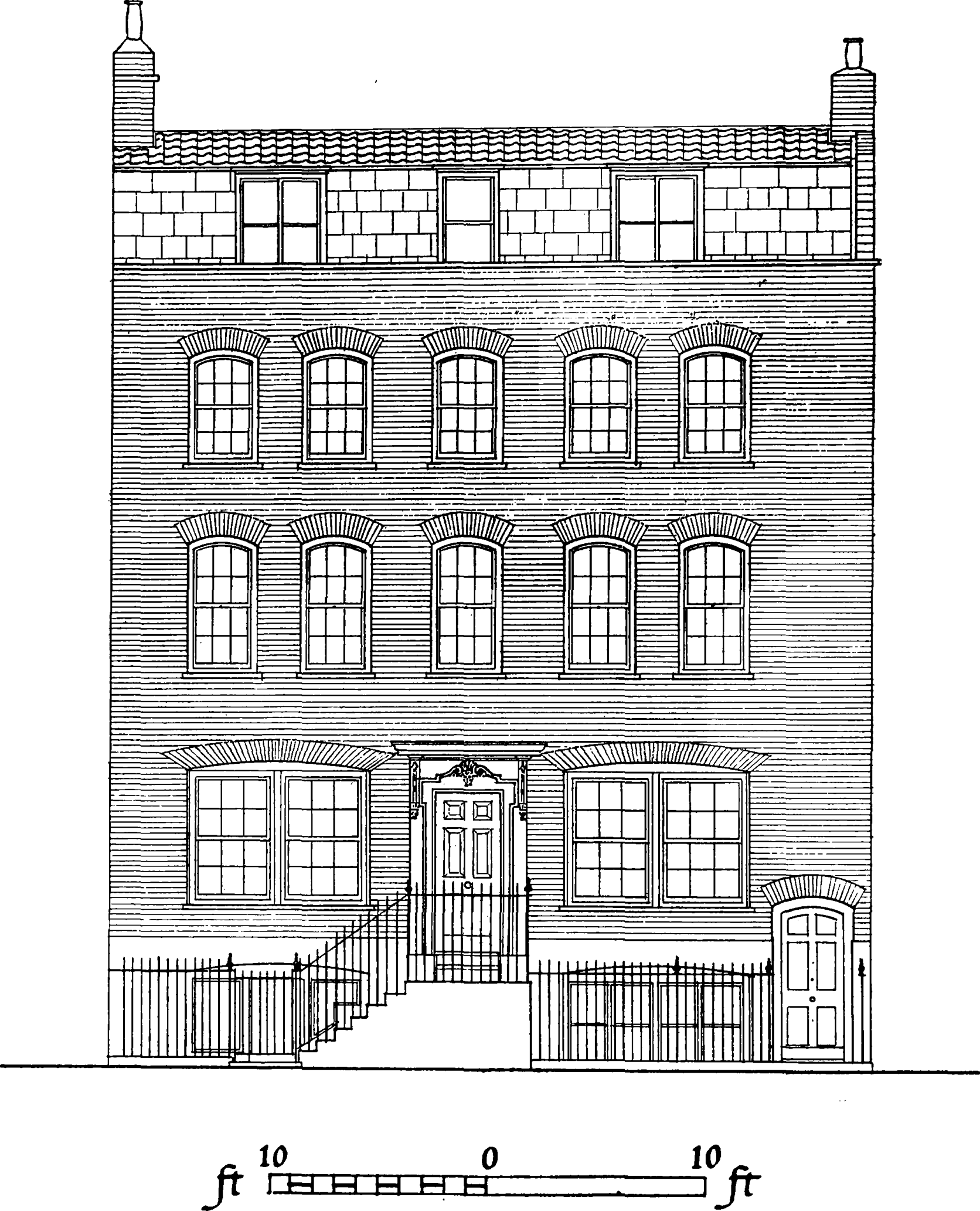
No. 36 Crispin Street (Plate 72b) had a well designed front of early eighteenth-century character, three storeys high and five windows wide. The original ground-storey treatment had been replaced by a shop-front of about 1800, but the upper part was intact in 1909. The facing was of stock brick, red brick being used for the moulded bandcourse between the second and third storeys, for the moulded cornice about the third-storey arches, for the architrave bands of the middle window feature, and for the jambs and gauged flat arches of the other windows. The middle window of the second storey had an eared architrave-band, the head of which was cut to a flattened ogee line. The window above had a similar eared architrave band with a raised keyblock and a sunk apron panel. All the windows were furnished with moulded flush frames, containing sashes with slender glazing bars. The finest internal feature was the steeply-rising staircase (Plate 95a), with its cut strings ornamented with acanthus-scroll brackets, and its moulded handrails supported by turned balusters and newels, both with barley sugar twisted shafts.
No. 37 Crispin Street
Spitalfields School of Design
Demolished
This school was founded with government support in 1842, (fn. 130) in accordance with a suggestion made in an Assistant Commissioner's report to the Handloom Weavers' Commission in 1840, and was chiefly concerned with designs for silk weaving. It was located in Crispin Street until 1865, when it moved to Folgate Street. (fn. 131) It was described in the rate book for 1844 as a School of Science. One of its first headmasters was George Wallis, later the Senior Keeper of the Art Collection at the South Kensington Museum. (fn. 128) In July 1848 a Spitalfields ball was held in aid of the school, and was attended by a very fashionable company. (fn. 132) It was criticized in the following year by a Parliamentary Committee for being insufficiently aware of the problems of manufacture; (fn. 133) the Victoria and Albert Museum contains, however, impressive examples of silk woven at the school. (See Spitalfields Silks of the 18th and igth Centuries, introduction by J. F. Flanagan, 1954, Plates 45 and 49 for work of pupils of the school in 1851 and of W. Folliott, weaving instructor, in 1873). In 1868 Timbs (who mistakenly spoke of it as being then still in Crispin Street) described it as the Government School of Design where are awarded prizes for designs for fabrics, drawing and painting from nature, crayon-drawing, etc. (fn. 134) After moving to Folgate Street the school appears to have been finally joined to the Bishopsgate Ward School in Primrose Street. (fn. 135)
No. 40 Crispin Street
Demolished
The architectural history of this building is not easily established, but it was probably built be- tween 1747 and 1750 by Joseph Gosford, a carpenter, who was then living a few doors to the south in the same street.
In March 1746/7 Sir Jacob Bouverie of Longford, Wiltshire (later Viscount Folkestone), granted to Gosford a seventy-one-year lease of a site with a sixty-eight-foot street-frontage, then said to contain two houses, on which Gosford was to build three houses. A yearly rent of 25 1 os. was to be paid until the houses were begun, a peppercorn during the year the same are building and 17 thereafter. (fn. 136) From an examination of the rate books it appears that No. 40 was one of the houses thus built, being still empty in 1750. (fn. 41)
A house occupying approximately the site of No. 40 had been occupied by Lewis Chauvet and Company, silk handkerchief weavers, (fn. 109) immediately before the rebuilding, when they moved to No. 39, the adjoining house to the north, which was described in 1755 as newly erected. (fn. 137)
In September 1755 a Daniel Garnault granted a sixty-four and a quarter year lease of No. 40, presumably subsidiary to the original lease from Bouverie to Gosford, to Francis Rybot, who then occupied No. 56 Artillery Lane. (fn. 137)
The first known occupant of the rebuilt house in 1759 and 1766 was William Holmes, a wine merchant. (fn. 109) In 1773 it was occupied by Henry Cline, who had by 1783 been succeeded by Widow Cline. (fn. 41) He was doubtless a relation of the distinguished surgeon, Henry Cline (17501827), (fn. 128) who in 1783, as of Devonshire Street, Bishopsgate, held the lease of the adjoining house. (fn. 138) In the early nineteenth century the house was occupied by a dry salter. (fn. 41) It was demolished by the Corporation of London for the Spitalfields Market extension.
The house was brick-fronted, with a shop and warehouse on the ground floor and three floors of living accommodation above. The character of the staircase details (Plate 95b) supports the suggestion that the building probably dated from the second quarter of the eighteenth century. This staircase, the lowest flight of which had been altered, had cut strings with carved brackets, turned balusters with twisted shafts, and a moulded handrail ramped to continue over the Doric column-newels. The first-floor front room was finely decorated, with excellent woodwork, a modelled plaster ceiling, and a carved marble chimneypiece (Plates 103a, 106a, c, e). Carving enriched the mouldings of the dado and door panels, the skirting moulding and chair-rail, and the door architrave, the last having a bold key fret fascia and a surrounding ovolo moulding ornamented with scallops and darts. An enriched modillioned cornice of plaster surrounded the ceiling, where four motifs were placed diagonally in the angles. These were formed of Rococo ornaments, shells, C-scrolls, and foliage, framing a circular medallion, each with a putto surrounded by symbols of one element, thus representing earth, water, fire and air. The white marble chimneypiece was somewhat coarse in design and execution. The jambs were adorned with fruit and flower pendants, and the panelled consoles above were partly overlaid by acanthus leaves. An architrave and frieze formed the lintel, the frieze being carved with foliage scrolls branching from a central tablet with a rayed Aurora-head. Two members of the cornice-shelf were carved. The back room was chiefly remarkable for its doorway, which was similar to that in the front room but had, in addition, a pulvino frieze carved with Rococo scrolls and garlands, and an enriched dentilled cornice with a swan-necked-scrolled pediment (Plate 98b).
Two other builders are known to have been employed by Bouverie in the street in the late 1740's. One was Thomas Ellis of Brick Lane, joiner, who had executed the joiner's work at the French Church in Fournier Street and built the adjoining minister's house, No. 39 Fournier Street (see page 221), and who in 1748 rebuilt a house, immediately south of No. 40 Crispin Street, which had been vacated by the first minister of the Fournier Street French Church when he occupied the minister's house there. (fn. 139) The other builder was Samuel Ireland of Wheler Street, bricklayer, who in 1747 rebuilt a house near or adjoining to the house built by Ellis, again to the south. (fn. 140)
Providence (Row) Night Refuge and Home and Convent of Mercy
The Providence (Row) Night Refuge was founded as a non-sectarian charity by the Reverend (later Monsignor) Daniel Gilbert in 1860. (fn. 141) In that year he opened a night refuge for homeless women and children in former stables in Providence Row, Finsbury Square. This accommoda- tion soon proved to be too small, and a freehold site in Crispin Street, including vacant ground (fn. 41) said to have been used for fairs was purchased, A new building from the designs of Messrs. Young (fn. 142) was opened in the latter part of 1868. It provided accommodation for 300 women and children, and 50 men, with a convent for the Sisters of Mercy who are in charge of the work. Annexes in Gun Street and Artillery Lane have subsequently been opened as hostels for working girls.
The building in Crispin Street is of institutional character, containing three lofty storeys and a basement, with a front of eclectic and forbidding character built in yellow stocks and dressed with stone. The windows are grouped in twos and threes by buttresses, and each storey shows a different form of window arch. Those of the ground floor are segmental and dressed with stone labels; those of the first Boor are round-headed, and those of the second floor are again segmental. The doorways are emphasized by cornice-hoods on consoles, coarsely detailed and over-large in scale. There is an attic storey to the pavilion at the north end of the front, and the body of the building has a pitched roof of slate.
Brushfield Street (fn. n9)
The part of the street east of Crispin Street was probably constructed in about 16723 when the southern side was built (see page 127), the northern side being built in about 1685 when the market area was laid out (see Plate 51a). No. 66, which survived until 1929, may well have been one of the original houses built on the south side (fig. 34).
In 1771 there was some rebuilding on the southern side by or for a William Lewis, (fn. 143) and in 1775 a new warehouse was built on the northern side by (William) Townshend (fn. 144) who was later a co-lessee of the market. The street continued to be known as Paternoster Row after the construction of its westward extension called Union Street, but in the mid_nineteenth century it was known as Union Street East. The appearance of the eastern extremity of the street is shown in an aquatint of 1815 (Plate 25a). The northern side was rebuilt in 18867 when the market was reconstructed, and the southern side set back in 1929 when it was rebuilt as the Corporation of London Fruit Exchanged. (fn. n10)
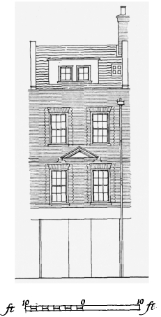
No. 66 Brushfield Street, c. 16723, front elevation. Based on a photograph of 1928
The part of Brushfield Street west of Crispin Street was constructed in about 17845 under Local Acts of 1778 and 1782, to join the western end of Paternoster Row to Bishopsgate Street. It lay within the Old Artillery Ground Liberty.
In 1771 when the Spitalhelds Vestry applied to Parliament for an Act, passed in the following year, for paving the parish (fn. 51) they asked also that the Act should provide for making such openings from and out of the said Parish into the Parishes Contiguous thereto as may be of Utility to the Publick. (fn. 145) No such provision was included in the Act, but in 1778 the construction of a new street was initiated. In February of that year two representatives of the City of London put before the Vestry a plan for Improvements in the form of a new street to be constructed from the eastern end of Chiswell Street in Finsbury across Bishopsgate Street into Spital fields. The plan was examined by representatives of the Old Artillery Ground and the parish of St. Mary Whitechapel. The Spitalfields Vestry decided to join with the City in applying to Parliament for an Act to make a street from Paternoster Row to Bishopsgate Street, to communicate with a line from Chiswell Street (fn. 146) which was built as Crown Street and a widened Sun Street and which is now largely obliterated by Liverpool Street Station.
Brushfield Street, south side, showing houses of 1780's
The more general purpose of the project was that an easy Communication for Carriages may be made between Moorfields and the great Road called Whirechapd Road, (fn. 147) in rather the same way as the construction of Commercial Street was conceived as part of a ring-road providing access to Whitechapd and the Docks from north London. (fn. n11) In 1805 the new street was said to form part of a grand line of communication from Spital Fields church to Smithfield, (fn. 149) to which Chiswell Street was joined by Barbican and Lone Lane. For Spitalfields parish the street had also the particular advantage that it provided direct access for wheeled vehicles to the market from Bishopsgate Street, which had not previously existed owing to the obstruction of Spital Square.
The Act of 1778 provided that to pay for the street 9,000 should be raised out of the Orphans Fund (fn. n12) which was administered by the City Corporation and had already been used for defraying the Expences of Several publick Works within the Cities of London and Westminster. (fn. 147) This sum was divided into a number of bonds which were conveyed by the Corporation to, and sold by, two Commissioners, as securities for annuities to be paid by the Corporation. By 1782 enough money had been transferred to the Commissioners for a second Act to be passed appointing a larger body or seventy_five Commissioners to put the Act into operation. They were empowered to purchase premises on the intended line and to build, pave and drain new street. Their powers of purcase were to lapse after five year. (fn. 151)
The Act prescribed that the houses in the new street should be so built as to range in a uniform and regular Line; and that no Porticoes, Benches or Bow-windows shall be made in or to the same. (fn. 151) This did not, however, prevent the erection of shops with shallow bow-windows, like those shown in Paternoster Row in the 1815 aquatint (Plate 25a), in the new street, some of which still survive in that part situated in the City.
In September and October 1783 the Commissioners acquired the leasehold and freehold of sites on the intended line, in Crispin Street and Steward Street. (fn. 152) By the autumn of 1786 the street was constructed and bore the name of Union Street. In November of that year the Commissioners granted assignments of leases or outright conveyances of sites, with newly erected houses on them, occupying all the southern side and most of the northern side of the new street between Crispin Street and Steward Street. On the northern side the grantees were a linen draper, grocer, tailor, weaver and silk manufacturer. On the southern side the grantees were a tallow chandler and James Benson of Spitalfields, carpenter. (fn. 153) One of the buildings on the northern side was built by John May Evans of Spitalfields, bricklayer. (fn. 154)
Union Street was described as a very excellent modern improvement in 1805. (fn. 149) In the 1830's it was said that the retail traffic of this neighbourhood is principally carried on in this street, from the situation of the vegetable market; It is a considerable thoroughfare, (fn. 155) and in 1845 the congested state of Union Street East was the subject of comment in evidence before the Commissioners for Metropolitan Improvements. (fn. 60) The part of the street situated in the Borough of Stepney continues to be used mainly for purposes connected with the market.
La Patente French Church
Demolished
On 5 September 1688 James II issued letters patent incorporating a body of ten French ministers and granting them a licence to establish one or more churches for the Huguenot refugees in the City and suburbs. The grant allowed them to exercise the functions of their ministry according [to] their manner used [in] France, Conformable to their Confession of faith, liturgy, and discipline by themselves heretofore in their Country used and exercised. (fn. 156) The resulting foundations were known as the two Patente churches. One was situated in Soho, while the other, after a short time in the City, moved to Spitalfields. (fn. 157)
The congregation of La Patente, Spitalfields, first met at Glovers Hall, in the ward of Cripple gate Without, (fn. 158) as appears from two entries in the marriage register for 1689 (fn. 159) and a lease, (fn. 122) now apparently lost. (fn. 158) The date at which the congregation moved to Spitalfields is not known. An index headed 1698, in the second volume of the registers, suggests that in that year it was meeting in Crispin Street. In 1707 the congregation was meeting in Paternoster Row, Spitalfields. (fn. 160) The building in which it met was situated somewhere within the area now bounded by Commercial, Brushfield, Crispin and Duval Streets. (fn. 161) The site of the building may have been in Little Paternoster Row, which is called French Alley on Rocque's map of 1746. The congregation found the place unsatisfactory because of the lowness of the situation, the closeness of the benches, the amount of rent, and uncertainty of possession, added to the fact, that many of their congregation were leaving for want of accommodation. (fn. 122) Accordingly, when the French Church at No. 36/363 Crispin Street disbanded in 1716, La Patente acquired a lease of that building (see page 138). It remained in Crispin Street until 1740, when it took over the former French Church in Brown's Lane (see page 191). La Patente remained there until 1786, when a union was arranged with the Walloon Church in Threadneedle Street. (fn. 158)
The Infirmary for Asthma, Consumption and other Diseases of the Chest, Brushfield Street
Demolished
This institution which developed into the Royal Chest Hospital, City Road, was founded in 1814 (fn. 162) at No. 36 (now No. 21) Brushfield Street. In January 1827 the committee of the infirmary, described as for Diseases of the Lungs, agreed to allow the overseers of the Old Artillery Ground, within which the infirmary was situated and to which it paid no poor rates, to have two outdoor patients on their books. (fn. 163) The Infirmary for Asthma is shown on Beek's map of 1833. (fn. 164) The infirmary was probably still at Brushfield Street in 1836, (fn. 41) but by 1837 had moved to No. 10 (now No. 41) Artillery Lane, which had previously been occupied by the London Dispensary, where it remained until 1847. (fn. 135)
White's Row
The roadway and northern side of this street formed part of the Wheler estate. The southern side was in the late seventeenth century owned by Nathaniel and John Tilly and in the eighteenth century by the Shepherd family. It formed the northern boundary of the tenter ground stretching south to Wentworth Street, which remained an open space until the nineteenth century (see Chapter XVI).
The line of the street appears to be shown, without buildings, on Faithorne and Newcourt's map which was published in 1658 but probably surveyed in the 1640's. In 1675 it was said that houses had been built on the south side of the street by Mr. Tilly about twenty-five years before: (fn. 165) this would have been roughly contemporary with the neighbouring development of the Fossan estate south of Fashion Street (see Chapter XVII).
The street was apparently not designedly laid out nor its northern side, at the southern end of Spital Field, built up until about 1673, when building at this southern end of the field was undertaken by Nicholas and Cooke, the Wheler trustees.
In the summer of 1675 Sir Christopher Wren made a report to the Privy Council on a complaint against Nicholas and Cooke from Nathaniel and John Tilly, the owners of houses on the south side of White's Row. He reminded the Council that when permission to build had been granted to Nicholas and Cooke in November 1672 (see page 127) for ye Builders better direction there was annexed a design to ye said Grant whereby a 24 foot Street is directed to be layd out and left open before the houses of Mr. Tilly which formerly fronted ye said fields on the South. Wren reported that Nicholas and Cooke, instead of making a street open on its northern side and twenty-four feet wide, had begun to build another row of houses fronting ye houses of ye said Mr. Tilly and had obliged the lessees to enclose sixteen feet of the proposed width of the street in front of the new houses and to convert ye same to private yards, leaving open only a passageway ten feet wide in front of Tilly's houses. They had also failed to provide sewers, as was required in their patent, and had raised the ground in front of Tilly's houses in such a way as to obstruct their ground floor and make them damp.
Nicholas and Cooke did not deny this. They pleaded that since the granting of the patent to them they had conveyed their interest in the estate to the Wheler daughters who had made a partition among themselves, by which the Datchett or Dorset Street and White's Row property came to Alice, the wife of John Whitehall. Eighty-year leases had been granted so that they, nor ye said John Whitehall nor Alice his wife have anything to doe with any part of ye same till ye said leases of 80 years be expired, the sole Interest being in ye Tenants . They claimed that all the ground of the new roadway was part of the Wheler estate and that Tilly, having built on the extreme northern limit of his land, possessed no right of access to his houses from the north save by sufferance of Nicholas and Cooke. They had left him a ten-foot way and were willing to allow a further sixteen feet if he would give a valuable consideration for it as was reasonable he should if he would have another man's ground. Wren replied that this was no answer to the charge that they had disregarded the conditions which had been laid down in the patent for ye publique convenience and which Nicholas and Cooke had themselves proposed. But as they alledge there was a Treaty depending for such a valuable consideration Wren suggested that if they were not compelled to conform to their patent all the parties to the dispute might be left to try their Rights by due course of Law. (fn. 165)
The precise outcome of this dispute is not known but the lessors and builders were obliged to make the roadway of its prescribed and present width, as appears on Ogilby and Morgan's maps of 1677 and 16812. These show nine houses in isolated groups on the northern side of the street, presumably those erected in contravention of the patent. The whole of the southern side is shown occupied by a row of small houses, those said to have been built by Tilly in about 1650. In Gas coine's map of 1703 the whole northern side is built-up.
A small drawing by F. W. Fairholt of 1844 (fn. 166) depicts the eastern end of the northern side of the street, built in irregular fashion, apparently in part of timber. A pencil drawing (Plate 55a) by T. H. Shepherd in the Bishopsgate Institute made at about the same time probably also shows the northern side of the street. (fn. n13)
The line of the street was a continuation of Fashion Street, forming with that street the southern boundary of the Wheler estate. It is called New Fashion Street on Ogilby and Morgan's maps of 1677 and 16812, and shares the name of Fashion Street on Gascoine's map of 1703. It was called White's Row at least as early as 1709: (fn. 167) the derivation of the name is not known.
The archway on the south side of the street shown in Plate 74a was constructed in the early nineteenth century to give access to the Tenter Ground estate (see page 242).
No. 5 White's Row
The identity of the builder of this house (Plate 72c) is not known, nor is its exact date, although it may have been built in about 17334.
Rate books indicate that the house was built between 1724 and 1743. At that period the houses on the southern side of the street as well as the tenter ground lying to their south were owned by Nathaniel Shepherd of St. Albans, gentleman. (fn. 168) In November 1733 he granted a sixty-one-year building lease to Henry Smith of Whitechapel, dyer, of a site, with a frontage of sixty-seven feet, on the southern side of the street. The position of this site is not certain but it was probably immediately to the west of the site of No. 5. The description of its abutments suggests that No. 5 was not then in existence: its site may have been cleared and it may have been built shortly afterwards. (fn. 169)
The house is double-fronted, containing a semibasement, three storeys, and a roof garret. The plan is simple, with the staircase compartment between two rooms of equal size, each with a small closet projecting at the back. The yellow brick front has five windows in each upper storey, but the first storey has one wide window, with paired sashes, on each side of the central doorway, the semi-basement windows being similar (fig. 36). All the windows, except those of the basement, have segmental arches of fine red brick, the wide arches of the first storey being skilfully formed with brick joints conforming to a much shorter radius than that of the arch segment. The straight-headed flush frames and sashes are modern, but those with segmental heads, in the second- and third-storey middle windows, are original. The wooden doorcase (Plate 81a, b) is based on a design published by both James Gibbs and Batty Langley. The door, with four fielded panels above the lock rail, is recessed in a rectangular opening framed by a Classical architrave, its outer mouldings eared and broken across the head into rising scrolls, flanking a bearded male mask surmounted by a scallop-shell. The cornice-hood is supported by upright consoles, rather large in scale, their sides carved with scrolls and the fronts with reeding and foliage. The front areas, and the side ascent of stone steps to the door, are guarded by simple railings of wrought iron, the standards having tall-necked urn finials. The front face of the mansard, containing three casement windows, is slated, and the upper slope of the roof is pantiled.
The interior is well finished, the rooms generally being lined with plain panelling. That in the staircase hall is set in ovolo-moulded framing, with a moulded chair-rail and a dentilled box cornice. The staircase has cut strings ornamented with carved brackets, turned balusters with plain and twisted shafts alternately, column-newels and moulded handrails, the soffit of each flight being panelled. The doors, with six fielded panels, are framed by wide Classical architraves.
In 1743 and 1759 the occupant was Thomas Jervis, esquire, succeeded by Mary Jervis who occupied the house in 1766 and 1783. (fn. 41) Jervis was a silk thrower who in 1744 was a trustee for the parish almshouses. (fn. 100) He was doubtless the Thomas Jervis who in 1745 undertook to raise four of his workmen against the Young Pretender. (fn. 170) In 1752 he was asked to lend the Spitalfields churchwardens 100, (fn. 171) and was in the same year a trustee under the Local Act for building a new workhouse. In 1770 the firm was known as Jervis and Son. (fn. 172)
No. 5 White's Row, ?17334, front elevation
In the early nineteenth century the house was occupied and owned successively by John McNeale and George Gozzard, both carpenters. (fn. 41)
White's Row Independent Chapel, Reformed English Church and Catholic and Apostolic Church
Demolished
This chapel (Plate 42b) was built, probably in about 1755, by a congregation of Independents under Edward Hitchin, which had met previously in Artillery Lane Chapel (fn. 173) (see page 37). (fn. n14) Many members of the congregation at this time are said to have had Huguenot names. (fn. 174) Hitchin died in 1774 and was succeeded by Nathaniel Trotman. The congregation was then large, drawing most of its members from within a mile of the chapel: Trotman's reception service was attended by 1,200 persons. He died in 1792 and was followed by John Goode, who served the chapel until his resignation in 1826, by which time the congregation had dwindled considerably. The Rev. Henry Townley became minister in 1828. In 1836 the congregation left White's Row, the lease having nearly expired, and after a short stay in Bury Street Chapel, built Bishops gate Chapel. (fn. 174)
Between 1840 and 1842 the building was taken over by the Rev. Robert C. Dillon (fn. 128) as a reformed English church. Dillon had been suspended from his cure at the proprietary chapel in Charlotte Street, Pimlico, in February 1840, as the result of an investigation of his private life after he had played a corrupt part in an irregularly conducted contest for the rectory of St. James's Clerkenwell in 1839. Dillon was a popular preacher and despite the notoriety which surrounded his personal life he retained a devoted following which included many wealthy women. Before coming to Spitalfields he and his congregation had met for a time in Friar Street, Black friars. In White's Row he appointed himself bishop or first presbyter and ordained ministers to serve other churches of his sect. Plans were being made to expand to some of the large industrial towns when he died suddenly on 8 November 1847 in the vestry. (fn. 175) In May 1847 the committee of the church had carried out alterations of unknown extent to the fabric. (fn. 178)
The next occupants of the building appear to have been the Catholic and Apostolic Church, who registered it for the solemnization of marriages in May 1851. (fn. 177) In 1856 the Rev. Joseph Laurence Miller is listed as minister of the church. (fn. 135) The building appears to have ceased to be occupied by the Catholic and Apostolic Church between 1873 and 1876. (fn. 178) It is not known when the building was demolished but it is not shown on the 18946 Ordnance Survey map.
White's Row Chapel was a fair-sized meetinghouse of oblong plan, with a gallery extending across the north end and along each side. The utilitarian exterior was, presumably, of brick and the decorative details, such as the wooden doorcases and window glazing bars, closely resembled those at the Artillery Lane Chapel, thus suggesting that the same builder was responsible. There were two tiers of five openings in the front, which finished with a pedimented gable-end containing a small round window. The two doorways, each approached by steps on either side, were placed between three round-arched windows, and the five windows above were alternately straight and round-arched, the last containing Gothick glazing bars. All the windows had heavy sills resting on plain consoles. The doorways were dressed with straight-headed architraves surmounted by triangular pediments resting on consoles.