A History of the County of Stafford: Volume 8. Originally published by Victoria County History, London, 1963.
This free content was digitised by double rekeying. All rights reserved.
'Stoke-upon-Trent: Buildings, manors and estates', in A History of the County of Stafford: Volume 8, (London, 1963) pp. 173-188. British History Online https://www.british-history.ac.uk/vch/staffs/vol8/pp173-188 [accessed 19 April 2024]
In this section
STOKE-UPON-TRENT
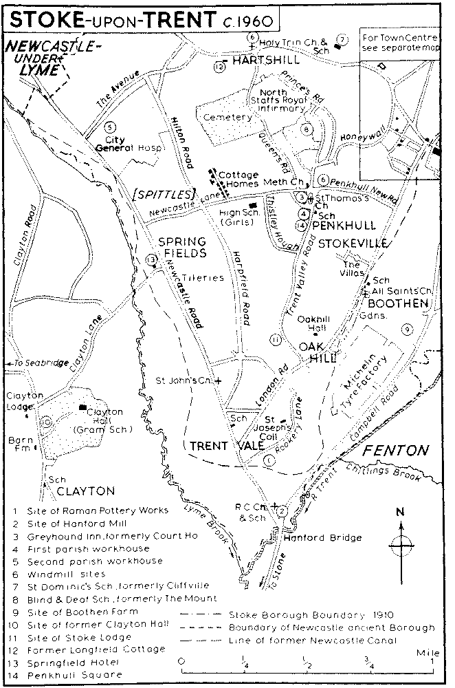
THE borough of Stoke-upon-Trent as it existed in 1910 covered an area of 1,882 acres (fn. 1) and comprised the old township of Penkhull together with a small area of former glebe around Stoke railway station which had once been part of Shelton township. (fn. 2) The boundary was largely natural. On the west it followed the Lyme Brook down to the Trent at Hanford and then turned north-eastward along the Trent as far as the Fowlea Brook. (fn. 3) The township boundary then followed the Fowlea Brook north-west to Etruria, but the borough boundary continued up the Trent for about a mile and then swung north-westwards to rejoin the Fowlea Brook, thus including the railway station. From Etruria the boundary ran west along the Newcastle road as far as Basford, and it then curved round the south-eastern part of Newcastle borough to rejoin the Lyme Brook. (fn. 4)
The township of Penkhull thus formed the southern end of a ridge lying between the Fowlea and Lyme Brooks and dropping down to the Trent, of which both brooks are tributaries. The ground rises, steeply in places, from below 350 ft. along these rivers, and in Stoke town itself, (fn. 5) to over 525 ft. around Penkhull and Hartshill in the centre and northern part of the borough area. The road from Derby, Uttoxeter, and the south-eastern part of the Potteries to Newcastle-under-Lyme crosses the Trent near Stoke church. Other roads run to Hanley and Leek. The main road from London and Stafford to Newcastle and the north of England runs through the western part of the former Stoke borough. The district is one of 19th-century urban development around Stoke church with Penkhull, Boothen, Hartshill, and Trent Vale as areas of suburban development dating from the early 19th century onwards.
In the Middle Ages the main centre of population was around Penkhull village, and Stoke itself then seems to have been nothing more than the place where the parish church was located. Even in the mid-18th century Stoke comprised little more than the church and the houses of the rector, curate, and parish clerk. (fn. 6) Already, however, there were at least three potworks a little to the west of the church, (fn. 7) and with the growth of the pottery industry in the later 18th century, the turnpiking of the road from Derby and Uttoxeter to Newcastle-under-Lyme in 1759, and the opening of the Trent and Mersey Canal in 1777, Stoke began to develop as a town. (fn. 8) Although it was still described as a village in 1795, (fn. 9) there was by then extensive building along both sides of the turnpike road from the church up to Cliff Bank. (fn. 10) By 1820 several new streets which had been laid out on the south side of this stretch of the road around the town hall of 1794 formed the nucleus of the growing town; buildings had also been erected in the Eldon Place stretch of London Road. (fn. 11) Glebe Street, Brook Street, and Wharf Street on the north side of the main road were built about the same time as the new church (1826–30). (fn. 12) The town was then described as 'pleasantly situated' on the Trent with 'many handsome houses, wharves, warehouses and earthenware manufactories'. (fn. 13) Houses were built along Liverpool Road in the late 1820's, (fn. 14) and several shops were erected there by William Copeland in the next decade. (fn. 15) A new road to Leek was run from the end of Glebe Street in the early 1840's; the railway and station were opened in 1848. (fn. 16) To Charles Dickens in 1852 Stoke was 'a picturesque heap of houses, kilns, smoke, wharfs, canals and river lying (as was most appropriate) in a basin'. (fn. 17) The third quarter of the century saw the building of the terraced cottages east of Leek New Road near the station and of the Copeland Street area, a mixture of factories and terraced houses, linking Glebe Street and Liverpool Road. (fn. 18) The area around Lonsdale and Woodhouse Streets was also beginning to be built up, and it was further developed in the last decade of the century over the grounds of the former rectory-house, known in the 19th century as Stoke Hall. (fn. 19) The triangle of streets between Liverpool Road, Shelton Old Road, and Hartshill Road dates mainly from the last quarter of the 19th century. (fn. 20) The town-centre was thus completely built up by 1900.
The hill-top village of Penkhull may originally have been a British settlement. It has been suggested that the name is a compound of the British 'pencēt' ('end of the wood') and the Old English 'hyll'. (fn. 21) Also a cup, possibly of prehistoric origin, has been found there. (fn. 22) By 1086 the village was the centre of the district, and it retained this status until the development of Stoke town in the 19th century. (fn. 23) It still possesses a certain village quality in the area round the church, which in 1842 replaced a school on the open space in the centre of the village known as Penkhull Green. (fn. 24) The character of Penkhull was, however, being modified by the early 19th century. Until then it was a village of small farmers, (fn. 25) with apparently some pottery making c. 1600. (fn. 26) Josiah Spode (d. 1827), who in 1803 built The Mount, a mansion standing in extensive grounds to the north of the village, (fn. 27) also erected cottages at the Penkhull end of Penkhull New Road and at Penkhull Square on what is now called Trent Valley Road (formerly Brisley Hill). (fn. 28) At Honeywall to the east of the village there were by 1829 'a number of houses, pleasantly situated on an elevated tract of land, possessing a fine view of the eastern side of the district.' (fn. 29) Penkhull was described in 1834 as 'a populous suburb of the town [Stoke], having many modern houses erected chiefly for the accommodation of the working-classes', (fn. 30) and c. 1840 as consisting 'of some farm-houses, a few genteel houses, and a number of modern workmen's dwellings'. (fn. 31)
Prince's Road, running from the west end of the street named Honeywall past The Mount to the Newcastle road at Hartshill, dates from the 1850's. It was laid out by Frederick Bishop, mainly with a better type of terraced housing, soon after he had acquired The Mount in the early 1850's. (fn. 32) By 1876 the roads to the east of Prince's Road were being laid out. (fn. 33) As a result of all this development some 1,300 more houses were standing in and near Penkhull in 1861 than in 1831. (fn. 34) The North Staffordshire Infirmary was moved from Etruria to the new buildings erected in 1866–9 on the northern part of the estate attached to The Mount. The remainder of the estate, including the house, was taken over by the North Staffordshire Blind and Deaf School in 1897. (fn. 35) Queen's Road, running from Penkhull round the west side of the infirmary to the north end of Prince's Road, was built c. 1884, mainly, it would appear, to give access to the new cemetery; (fn. 36) it contains a few houses at either end, mostly of the late 19th century, and also the laboratories of the British Ceramic Research Association. (fn. 37) The Trent Valley Road area south of the village is mainly a residential district dating from the late 19th century onwards. (fn. 38) The houses on the west side of the road for about half a mile below Penkhull Square were built as a garden suburb after 1910. (fn. 39) There is also extensive housing of the years between the world wars along Newcastle Lane and to the north of it, in St. Thomas Place, off the north end of Prince's Road, and to the west of the Cliff Bank end of Honeywall. A council estate begun between Honeywall and Penkhull New Road since 1945 is still (1960) growing; part of it is built on the site of the old cottages. Another post-1945 estate has been built in the area around Hilton Road and Lodge Road north of Newcastle Lane, (fn. 40) and the estate in the Thistley Hough area off Trent Valley Road is still expanding.
The fine stipple indicates built-up areas.
Boothen had grown up as a smaller settlement on the Trent below Penkhull by the early 15th century. (fn. 41) The hamlet still existed in the early 1920's centring on Boothen Farm and the Plough Inn, (fn. 42) but already by the 1870's the development of Stoke town along London Road was reaching as far south as the Boothen area; several of the side streets off that road had been built up, notably the Stokeville area which extends between London Road and what is now Trent Valley Road. (fn. 43) In the early 1880's Campbell Road had been built as a continuation of Lonsdale Street as far as Boothen hamlet, cutting across the more circuitous old road. (fn. 44) By 1898 both Campbell Road and London Road were built up as far as the Boothen area, and Corporation Street had been made linking the two. (fn. 45) The centre of the district thus moved to London Road where the church, the school, and most of the shops are situated. The terraced houses in Birks Street, Lime Street, and Fielding Street, between the northern part of Campbell Road and the river, and the housing in Corporation Street and the streets to the north date from the end of the 19th century and the early years of the 20th century. (fn. 46) Campbell Road was continued south to the main Newcastle-Stone road at Hanford Bridge in 1923–4, (fn. 47) and the Michelin tyre factory was opened in 1927 to the south of Boothen hamlet. (fn. 48) There are now (1960) other smaller factories between Campbell Road and the river and off London Road. A large council estate in Water Street and Fletcher Road was completed in 1927. (fn. 49) The housing in Chamberlain Avenue and at the end of Penkville Street, both on the west side of London Road, is also of the years between the world wars.
The Oak Hill district around the junction of London Road and Trent Valley Road originally centred on the early-19th-century Oak Hill Hall (fn. 50) and the older Stoke Lodge to the west. (fn. 51) By 1820 there were several buildings on London Road by Oak Hill Hall and on what is now Racecourse Road opposite, including a soapworks. (fn. 52) Little more was built there during the rest of the 19th century, (fn. 53) but at the end of the century the triangle of streets on the south side of London Road was laid out; the streets around the hall had also been begun, and they were completed in the course of the next 20 years or so. (fn. 54) A council estate on the site of Stoke Lodge was finished in 1924, and by 1939 further housing had been erected in both areas, including more new streets round Oak Hill Hall. (fn. 55)
In the first and second centuries a.d. there was a Roman potworks on the rising ground above the Trent near the present Trent Vale Brick Works. (fn. 56) The modern Trent Vale, however, extending along the Newcastle road from Hanford Bridge, developed as a residential district in the early 19th century. (fn. 57) By the 1830's there were several 'villa residences . . . snug, rural boxes', as well as brick and tile yards on the canal, (fn. 58) and in 1843–4 St. John's Church was built. (fn. 59) Although there are still some 19th-century cottages along the Newcastle road and in the Flash Lane area, Trent Vale consists mainly of extensive 20th-century housing, (fn. 60) with a strip of meadow land along the Lyme Brook. The area east of the church, including Harpfield Road and the streets around The Crescent, and most of the streets between London Road and Rookery Lane were built up by 1922, and by 1939 both these areas had been extended and new estates laid out between the Newcastle road and the Lyme Brook. (fn. 61) The years since 1945 have brought further development in the southern part of the area. (fn. 62)
Spring Fields to the north existed by 1775 as a group of houses around the junction of the road from Clayton with Newcastle Road. (fn. 63) There was a tilery on the site of the present works there by 1832. (fn. 64) Most of the present housing is of the years between the world wars and of the post-1945 period, and there is a post-1945 estate of pre-fabricated houses off Harpfield Road on the slope to the east. (fn. 65) There are two bakeries and several factories on the main road there. The group of streets in the Stubbs area to the east of the main road before it enters the borough of Newcastle had been built by the 1870's. (fn. 66)
Hartshill occurs as a name attached to land in Stoke parish c. 1600 (fn. 67) and was an inhabited area by 1738. (fn. 68) In 1775 most of the building there was around the junction of what are now called Hartshill Road and Stoke Old Road. (fn. 69) It thus lay west of the present Hartshill which centres on the church. By 1820, however, the district was developing eastwards. (fn. 70) The larger houses included Cliffville above Cliff Bank, built in 1810, (fn. 71) and Longfield Cottage opposite the Noah's Ark Inn. (fn. 72) The latter was the birthplace in 1826 of Dinah Maria Mullock, later Mrs. Craik and author of John Halifax, Gentleman. Her grandmother, Jane Mellard, had moved there c. 1816, and the Mellards remained at Longfield Cottage until 1831 (fn. 73) after which it was the home of Herbert Minton (d. 1858). (fn. 74) Minton built cottages for his workers on both sides of the main road near the church, and these are still occupied. (fn. 75) There were also several brick and tile yards in the Hartshill area by the 1830's. (fn. 76) Holy Trinity church was built in 1842. (fn. 77) Shelton New Road, built in the 1830's, joins Hartshill Road at the Stoke-Newcastle boundary, (fn. 78) and by 1850 there had been extensive building round this junction, representing the eastward spread of Newcastle. (fn. 79) There had also been some development north and south of the main road round Hartshill church by this time. (fn. 80) Victoria Street linking Hartshill Road at Harpfield with Etruria Road at Basford was constructed c. 1880. (fn. 81) The streets of terraced cottages south of Hartshill Road opposite the end of Victoria Street were laid out at the beginning of the 20th century. (fn. 82) The stretch of The Avenue in this area had been built by the early 1920's, (fn. 83) and this road, which serves a residential district as well as providing a southeastern by-pass of Newcastle, had been extended to Newcastle Road by 1939. The housing estate on the north side of Hartshill Road, between Victoria Street and the 19th-century streets west of Hartshill church, dates from the years between the world wars. Some of the houses in this part of Stoke Old Road were rebuilt during this period, while the extension of Cumming Street to the north-east contains a post-1945 council estate. (fn. 84) Slum clearance and rebuilding were still in progress in the pre-1850 Steel Street area south of Hartshill church in 1959. (fn. 85)
Cliff Vale, apparently the whole area of low ground along the Fowlea Brook between Shelton Old Road and Etruria Road, (fn. 86) contained several brickworks at the northern end of Stoke Old Road (now Brick Kiln Lane) by 1832. (fn. 87) It began to be developed only towards the end of the 19th century when Garner Street was built from the Etruria Road end of Brick Kiln Lane down to Shelton New Road with several terraces of houses along its southern end. (fn. 88) A council estate was laid out during the years between the world wars on the north side of Shelton New Road between Brick Kiln Lane and Garner Street. (fn. 89) North Street, running from Shelton Old Road to Shelton New Road, was built in two stages in the later 19th century, (fn. 90) but contains only two groups of houses, both of the 20th century. The steeply rising ground on the Hartshill side of North Street is still (1960) undeveloped.
Basford lies on both the Stoke and the Wolstanton sides of Etruria Road which at this point was known as Basford Hill or Basford Bank by the 1830's. (fn. 91) There were then several brick and tile yards in the area, especially along Stoke Old Road (then Stoke Lane), and Stoneyfields House, still standing in the north-eastern extremity of the area, had also been built by then. (fn. 92) Several streets of larger houses were laid out on the Stoke side of Etruria Road in the third quarter of the 19th century, (fn. 93) and the streets in the Kingsfield area to the west date from c. 1900; (fn. 94) all these streets were continued southwards in the years between the world wars. (fn. 95)
The population of Penkhull in 1086 was recorded as 17 villeins and 6 bordars. (fn. 96) Only 13 inhabitants in the vill paid tax in 1332, (fn. 97) while in 1666 44 persons in the Penkhull, Boothen, and Stoke portion of Penkhull constablewick were chargeable for hearth tax. (fn. 98) There were 40 or 50 houses in this district c. 1680. (fn. 99) The population of Penkhull and Boothen township (including Stoke itself) was 419 in 1701 (fn. 100) and 3,851 in 1811; (fn. 101) in 1831 the population of Penkhull was 5,876 and that of Boothen 121. (fn. 102) In 1871 the figures were 12,959 and 767 respectively, and the continuing increase was then attributed to the prosperity of the pottery industry and the facilities for building offered by clubs. (fn. 103) In 1901 the population of the borough was 30,458, and in 1911 the population of the same area was 36,375 and in 1921 37,935. (fn. 104)
The road from Derby and Uttoxeter through Stoke to Newcastle follows the course of the Roman Ryknield Street as far as Fenton and there turns west to cross the Trent at Stoke. (fn. 105) It was evidently in use by the 13th century, (fn. 106) and was turnpiked in 1759. (fn. 107) The stretch between Stoke and Newcastle, now Hartshill Road, is said formerly to have followed a more northerly and direct line from a point near the Jolly Potters Inn, returning to the line of the present Hartshill Road along the western part of Stoke Old Road (formerly Stoke Lane). (fn. 108) Shelton Old Road, formerly Hanley Road, (fn. 109) was turnpiked from Cliff Bank to Shelton in 1763, the first stage of the link from the Derby-Newcastle turnpike to that from Lawton (Ches.) through the northern part of the Potteries. (fn. 110) This link was completed in 1765 along a side road from Shelton to Etruria as part of the turnpiking of the road from Newcastle to Hassop (Derb.) via Etruria and Cobridge. (fn. 111) The Etruria Road stretch of this road from Newcastle Hassop formed the northern boundary of Penkhull township. This portion was stated in 1780 to be in such a bad state of repair, despite considerable expenditure, 'that post-chaises from Newcastle-under-Lyme to Leek go another road two miles longer'. (fn. 112) By 1849 there was a toll-gate at the point where this road is joined by Stoke Old Road. (fn. 113) Shelton New Road which runs up from the Fowlea Brook at Cliff Vale to meet Hartshill Road at the Newcastle boundary was built in the late 1830's under an Act of 1823. (fn. 114) North Street was built from Shelton Old Road along the low ground by the Fowlea Brook during the third quarter of the 19th century and was continued to Shelton New Road before the end of the century. (fn. 115) The road from Stoke to Endon running from Church Street along Glebe Street had been built by 1842 under an Act of 1840. (fn. 116) At first it crossed the railway by a level crossing; the Improvement Commissioners' schemes for a bridge, drawn up in 1852, were thwarted for many years, evidently by the railway company, and the present railway bridge was not built until 1868. (fn. 117)
The western part of the area is crossed by the ancient highway from London to Carlisle. (fn. 118) The stretch in Penkhull township was turnpiked in 1714 as part of the road from Tittensor to Talke, the first Staffordshire turnpike. (fn. 119) By 1791 there was a tollgate, known as Knappers Gate, at Spittles where a road from Penkhull, the present Newcastle Lane, joined the main road. (fn. 120) This still stood in 1878. A hilly side road led from the highway along the present Rookery Lane just south of the Black Lion Inn at Trent Vale, up Brisley Hill (now Trent Valley Road) to Penkhull and thence down Honeywall to join the road from Derby to Newcastle at Cliff Bank; another road ran from the foot of Brisley Hill to Boothen, and thence to Stoke. (fn. 121) A new road, the present London Road, more direct than either of these, was built in 1791–2 under an Act of 1791 from the 'Black Lion' at Trent Vale and along the foot of the steep slope below Penkhull to meet the road from Derby to Newcastle at what is now Campbell Place; it was continued on the other side of this main road by the construction of Liverpool Road ('the new road to Shelton') to join Shelton Old Road near Shelton Wharf. (fn. 122) A toll-house was built in 1792 at the junction with Brisley Hill, (fn. 123) superseding an older toll-house nearby which was sold in 1793; the second house still stood in 1878. (fn. 124) A chain was placed across the Stoke end of the road, but proving unnecessary it was removed a few weeks later. (fn. 125) In the early 1880's Campbell Road, parallel to and east of London Road, was run from Lonsdale Street, Stoke, to Boothen, cutting across the more circuitous old road to Boothen which, however, still survives as Boothen Road and Boothen Old Road. (fn. 126) In 1923–4, as one of the unemployment relief works, Campbell Road was continued south to meet the Newcastle road at Hanford Bridge. (fn. 127)
There were two ancient bridges over the Trent within Penkhull township, Stoke Bridge on the road from Derby to Newcastle, and Hanford Bridge on the main highway south from Newcastle. Stoke Bridge was stated in 1568 or 1569 to be repairable by several of the neighbouring townships. (fn. 128) It was apparently repairable by Stoke parish in 1666, (fn. 129) but its upkeep was a county responsibility by 1668. (fn. 130) Repairs carried out in 1717, 1718, and 1720 included 'securing the arch', (fn. 131) and in 1792 the bridge was widened. (fn. 132) By 1864 it was a bridge of stone and brick with four arches. (fn. 133) Hanford Bridge was a structure of at least three arches by the late 17th century. (fn. 134) Its maintenance too was a county responsibility by 1625. (fn. 135)
Boothen Bridge, which was repairable by Stoke parish in the late 17th century, (fn. 136) may have been a bridge over the Trent leading to Fenton mill. Complaints were made in 1856 and again in 1869 about the dangerous state of the bridge carrying the footpath between Boothen and Fenton over the Trent, (fn. 137) and there is still a footbridge over the river near the site of the former Fenton mill.
There were two ancient bridges over the Fowlea Brook on the eastern boundary of the township, one carrying the road from Penkhull to Shelton via Cliff Bank and the other the road from Newcastle to Cobridge; a third was built at the end of the 18th century. The first seems to be identifiable with the 14th-century Wolfordbridge, (fn. 138) and it occurs in the 16th century as 'the bridge at the Fowle Ley going from Shelton to Penkhyll', for the repair of which Nicholas Adams of Sneyd (d. 1567) bequeathed a plank of wood. (fn. 139) It occurs variously as the Fowlea Bridge and the Lower Fowlea Bridge during the 17th century, when its maintenance was a regular charge on Stoke parish, (fn. 140) and as Fowlea Bridge in 1727 and 1728. (fn. 141) The Upper Fowlea Bridge carrying the Newcastle-Cobridge road over the brook is mentioned in 1660 as a parish responsibility (fn. 142) and by 1832 was known as Etruria Bridge. (fn. 143) It was a county bridge by 1864 when it was of brick with one arch. (fn. 144) A third bridge was built over the brook within Penkhull township when the turnpike road from Trent Vale to Shelton Wharf was constructed in 1791–2. (fn. 145) It was either this Liverpool Road Bridge or the Lower Fowlea Bridge that occurs in 1830 as Shelton Bridge, a new structure and the responsibility of the county. (fn. 146) In 1856 the Improvement Commissioners complained to the justices about the state of the Liverpool Road bridge. (fn. 147)
A bridge carrying the footway between Penkhull and Clayton over the Lyme Brook and another bridge nearby were stated in 1712 to be in need of repair. (fn. 148) The first was probably the bridge in what is now Clayton Lane. (fn. 149)
By 1790 Stoke was served by the same coaches as Burslem, the 'Wheatsheaf' being the coaching inn by 1818. The town was on the route of a HanleyStafford-Birmingham coach by 1824, and by 1834 the thrice-weekly coach between Newcastle and Derby called at the 'Wheatsheaf'. (fn. 150) By 1851 there was an omnibus service from Stoke Station to Newcastle and to Hanley. (fn. 151) By 1854 there were omnibuses from the 'Wheatsheaf' to the railway station to meet each train, and there was also a service between Longton and Burslem which called at the 'Wheatsheaf'. (fn. 152) A steam tramway was started between Stoke and Longton in 1881 and extended to Hanley and Burslem in 1882. (fn. 153) A branch-line to Oak Hill was opened by 1892. (fn. 154) Tramway offices and sheds were built in Woodhouse Street in the 1890's, and electricity, generated from there, was substituted for steam by the Potteries Electric Traction Company in 1899. (fn. 155) A line was built to Newcastle in 1900–4, and the Oak Hill branch was extended to Trent Vale in 1899–1905. (fn. 156) Motorbuses, introduced from 1914, gradually replaced the tramcars between 1925 and 1928. (fn. 157)
By 1790 one of the innkeepers was the post-master of Stoke. (fn. 158) From 1835 Stoke was linked by a horsepost with Newcastle, the postal centre of the Potteries area. Stoke became the centre in 1854 when a head office for the Potteries was opened at the railway station. (fn. 159)
The Trent and Mersey Canal, opened in 1777, (fn. 160) runs through the north-eastern portion of the former borough, and a low aqueduct of three arches was built to carry it over the Trent. (fn. 161) By 1802 there was at least one public wharf in Stoke, and this, off Wharf Street, remains in use. (fn. 162) The Newcastle-underLyme branch was built in 1795–6 under an Act of 1795 from the main canal north-west of Glebe Street along the east side of London Road to Trent Vale where it passed under the main Newcastle road at the west end of Rookery Lane; it then ran north through the meadows by the Lyme Brook to Brook Lane in Newcastle. (fn. 163) Its purpose, according to the preamble of the Act, was to provide for Newcastle and the works near it a link with the main canal and to 'assist the agriculture of the neighbourhood of the said canal by a supply of lime at less expense'. It appears, however, never to have been a profitable venture, (fn. 164) and under an Act of 1921 the stretch from Newcastle to Trent Vale was filled in. (fn. 165) The remainder also had been filled in as far as a point just north of Church Street by 1938, when a further Act allowed the stopping up of the canal as far as its present termination at Aqueduct Street. (fn. 166) This left only a side arm from the main canal about 100 yards long, over which the main towpath and Copeland Street are carried on original hump-backed bridges. There was a wharf at the junction of the two canals by 1832, and this was still in use in 1916. (fn. 167) In 1960 the wharf and the short length of branch canal were being used by the Stoke-on-Trent Boat Club.
The railway between Stoke and Norton Bridge, the first part of the present London-Manchester line, was opened in 1848, some eighteen months after the cutting of the first sod at Stoke; (fn. 168) later in the year the line was extended to Crewe and to Congleton. There was at first a temporary station at Whieldon's Grove (in Fenton), but this was replaced later in the year by the present Stoke station built on land called Winton's Wood then in Shelton township. (fn. 169) Etruria station, on the main line from Stoke to the north, lies just within the boundary of Penkhull township. (fn. 170) The branch line from Stoke to Newcastle, tunnelling under the high ground north of Hartshill, was opened in 1852. (fn. 171) There is also a side line from the Michelin tyre factory to the main line at Sideway, south of Stoke.
Buildings
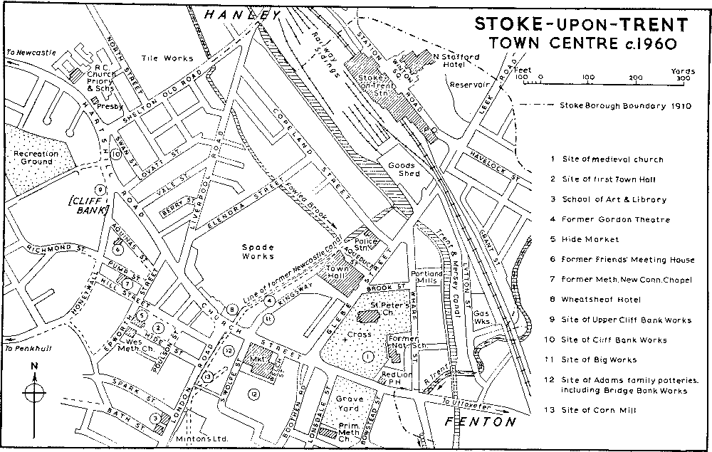
Only a few of the buildings along the main street of Stoke survive from the early development of the town in the years immediately before and after 1800. Most of the frontages have been rebuilt, several of them in the different ornate styles of the late 19th and early 20th centuries. The Grapes public house, a substantial late-18th-century building on the corner of London Road, and probably the oldest house in the centre of Stoke, was demolished in 1960. Although altered, perhaps at the time of its conversion to an inn c. 1865, (fn. 172) it retained a Georgian façade of five bays with a central pedimented doorcase and a dentil cornice; there was also a plastered back wing with hipped dormer windows. The Wheatsheaf Hotel, facing the end of London Road, is still recognizable as the coaching house of c. 1820, although its long three-storied front was altered later in the 19th century. Farther west in the main street are three early-19th-century residential properties; the present offices of the City Registrar with its original stable range beside it, the Clifton Hotel, and the stucco house now used as a presbytery for the Roman Catholic church. Near the corner of Vale Street a row of brick cottages with front gardens has survived from c. 1800.
The area of small streets lying south-west of the main street and surrounding the former town hall and market-place formed the nucleus of the town early in the 19th century. Apart from dwellinghouses, both terraced cottages and slightly larger double-fronted houses, the older buildings include the striking Wesleyan Methodist Chapel (1816 and later), (fn. 173) the chapel of the Methodist New Connexion (1816) (fn. 174) and the former Friends' Meeting House, built as an Independent chapel in 1823. (fn. 175) The original town hall, built in 1794 and demolished c. 1938, was on the usual pattern with an open arcaded market below and a meeting-room above. (fn. 176) Immediately to the west stands the covered market of 1835, still (1960) in use as a hide and skin market. (fn. 177) Where the ground falls away to the east it has a good brick front with stone dressings, the central projecting bay being surmounted by a pediment and flanked by arched entrances with iron grilles; the flights of stone steps leading up to them have been partly cut away. At the lower end of Honeywall a few early houses remain, although there has been much demolition of small property in this area. A Russian gun, presented to the town by W. T. Copeland in 1857 and erected opposite the 'Wheatsheaf' in 1858, was moved to a site in Hill Street by the old town hall c. 1874. (fn. 178)
The former National school, (fn. 179) occupying the south-east corner of St. Peter's churchyard, was built in 1815. It consists of a rectangular two-storied brick range of six bays, the ground-floor openings being pointed and having heavily moulded brick jambs and arches. A projecting feature surmounted by an octagonal turret at the south end of the building disappeared during later extensions (fn. 180) and a date tablet of 1815 has been re-set. Glebe Street and Brook Street, bounding the extended churchyard on the north and west and laid out with it shortly before 1830, were said soon afterwards 'to present an agreeable uniformity of character'. (fn. 181) Both streets are open to the churchyard, giving a certain spaciousness and dignity to this part of the town. Shop fronts have been inserted in the stucco terrace houses of Glebe Street but several original doorways with elliptical fanlights survive. Brook Street, containing a terrace of what was described c. 1840 as 'a superior class of houses of the bay window stile of architec ture', (fn. 182) is comparatively unaltered. The houses, now mostly occupied as professional offices, are of yellow brick and have 'Tudor' doorways and mullioned windows; the two end blocks are of somewhat later date. Farther north, on a wedge-shaped site between Glebe Street and Wharf Street, a striking Italianate stucco building was erected as a hotel in 1854 (fn. 183) but is now used as offices; the angle is occupied by a circular staircase hall surmounted by a lantern.
STOKE-UPON-TRENT TOWN CENTER c.1960
The approach to the railway station represents one of the few attempts at a formal layout to be found in the Potteries. The station itself, built in 1848, (fn. 184) has a long two-storied brick front in the contemporary 'Tudor' style with a projecting gabled wing at each end. In the centre is a stone portico of seven arches, surmounted by a square bay ornamented with strapwork and other Jacobean detail. Directly opposite is the North Stafford Hotel, also dating from 1848 (fn. 185) and built to resemble a tall Elizabethan manor house with 'Flemish' gables, stone dressings, and blue diaper ornament to the brickwork. Flanking it are lower buildings in the same style which, with the hotel, form three sides of Winton Square, the fourth side being occupied by the front of the station. In the centre of the square stands a bronze statue of Josiah Wedgwood, erected by subscription in 1863. (fn. 186)
Stoke town hall in Glebe Street is the largest and most imposing municipal building in the six towns. It was begun in 1834 to an ambitious Classical design by Henry Ward, but the north wing was not built until c. 1842 and the south wing was still unfinished in 1850. (fn. 187) The long stone front includes a main block of thirteen bays, having tall windows to the upper floor and a projecting central Ionic portico surmounted by blocking courses and a small pediment. The pedimented side wings also project and are of three stories. The whole is raised on a rusticated base containing round-headed windows and three central arched entrances in the centre. There was originally a space in the centre of the building used as a market-place, but in 1888, five years after the removal of the market to Church Street, the space was reconstructed to include the council chamber, mayor's parlour, and municipal offices, all formerly housed in the south wing. (fn. 188) The building was retained after 1910 for most of the new county borough's activities, and the King's Hall, seating 3,250, was erected behind it in 1910–11. (fn. 189) The extensions were designed in a free Classical style by T. Wallis and J. A. Bowden of London (fn. 190) and executed in stone. In 1935 the first-floor assembly room in the main building was reconstructed as the Jubilee Hall and the glazed tiles with which it had been lined, probably in 1888, were covered over by wood panelling. (fn. 191)
Public buildings to the south of Church Street include the market of 1883, (fn. 192) built of red brick in the Flemish style with curly gables and a central tower; the low front with its row of shops was apparently added in 1900. (fn. 193) In London Road the College of Art (1858–9 with later additions at the rear) (fn. 194) is Gothic in style and has ornamental terracotta bands and window-heads. The adjacent library and museum (1877–8) (fn. 195) is of strikingly original design, having circular windows to the principal floor and an upper story of timber with wide eaves and casement windows; between the two are decorative panels of tile and mosaic. On the opposite side of London Road is the most impressive of the industrial buildings in the town-centre. This factory, belonging to Mintons Ltd. and dating from about the middle of the 19th century, has a very long three-storied front, rising in the centre to four stories. Its line is continued to the south by the Campbell Tile Works, built by 1876 in much the same style. (fn. 196) Near the modern additions to the Minton factory at its northern end is a statue of Colin Minton Campbell, unveiled in 1887, the sculptor being Thomas Brock (1847–1922). (fn. 197) It originally stood in Campbell Place but was later moved to Kingsway to relieve traffic congestion; it was removed to its present site in 1954. (fn. 198) A Gothic drinking fountain at the angle of a factory building on the opposite side of London Road was presented by Colin Minton Campbell in 1859. (fn. 199)
The old village centre at Penkhull still contains several rows of rural cottages grouped round or near the triangular green on which stands the 19thcentury church of St. Thomas. A single cottage row also survives among newer houses in the hamlet of Honeywall, lying on the winding road between Penkhull and Stoke. There do not appear to be any cottages dating from before the late 18th century. Penkhull also possesses several groups of workers' houses of a slightly later period, including those built by Josiah Spode II (d. 1827) (fn. 200) and those in Penkhull New Road known as 'Commercial Buildings'. The former Stoke-upon-Trent parish workhouse is a plain three-storied building with a plastered front standing on the south side of Penkhull Green and now used as several dwellings. It appears to have been rebuilt or much altered since the time when it ceased to be used as a workhouse. (fn. 201) On the west side of the green is the Greyhound Inn, incorporating the former court house of the manor of Newcastleunder-Lyme. (fn. 202) It was largely rebuilt in 1936 but parts of the original timber-framed structure, probably dating from the 16th century, were preserved. The main block, which is parallel with the road, and a small back wing are still of timber construction, but a two-storied cross-wing at the south end has been entirely rebuilt in brick. The massive chimney between this and the main block formerly had stone fireplaces with four-centred arches on both floors, but the one which survives in the central bar was moved from the room above in 1936. A small room at the north end of the building is lined with 16thor early-17th-century panelling, partly reset. A court-room with oak benches round the walls and a seat for the presiding official is said to have been in existence until the alterations of 1936. (fn. 203) Elm Tree House in Garden Street, formerly a farm, has a dated tile of 1694 built into its front wall but the house has been much altered. A tile of the same date was recently removed from a brick outhouse in Newcastle Lane. (fn. 204) The Grove, known earlier as Beech Grove (fn. 205) and now altered and enlarged as a nursery school, stands in its own grounds at the junction of St. Thomas Place and Doncaster Lane. It is largely a brick building of the late 18th century but during reroofing in 1925 the timbers of three older gables were discovered at the back. (fn. 206) At the time of the riots in 1842 the house was occupied by the stipendiary magistrate whose servants were said to have saved the family silver by hiding it in a pig trough. (fn. 207)
The Mount, a large house standing half-way between Penkhull and Hartshill in what were formerly extensive grounds, has been incorporated in the North Staffordshire Blind and Deaf School since 1897. It was built in 1803 by Josiah Spode (II) and c. 1840 was said to hold 'acknowledged pre-eminence' among the mansions in the district. (fn. 208) The original tall two-storied west front is still visible between later additions. It is built of brick and has seven windows to each floor, the three central windows being contained in a bowed projection of stone surmounted by a dome. Part of a brick stable block belonging to the house stands in Greatbatch Avenue, while a small lodge with a Classical stone portico survives at the junction of Prince's Road and Mount Avenue. In the 1870's two ice-houses still existed in the grounds, one in the shrubbery north of the house and one near the north-east corner of the present cemetery. (fn. 209)
The house called Cliffville stands in a commanding situation north of Hartshill Road on the western outskirts of Stoke. It was said c. 1840 to be 'little inferior in any respect to the Mount' and its grounds to have 'attained a high degree of sylvan beauty'. (fn. 210) The house, occupied since the 1920's as a girls' school in connexion with the Dominican convent, was built in 1810 by John Tomlinson (fn. 211) and is a typical rectangular two-storied building of the period with a Classical porch at its east end. Longfield Cottage, opposite the 'Noah's Ark' at Hartshill, is a low-built early-19th-century stucco house which now houses the Hartshill Orthopaedic Hospital. (fn. 212)
Springfields Hotel, formerly Springfields House, which stands west of Newcastle Road at its junction with Clayton Lane, is a square brick building with stone dressings and a central pediment, dating from the later 18th century. The symmetrical two-storied front is of five bays, the windows having stone lintels with raised keystones. The central first-floor window is emphasized by a stone architrave, the doorway below it being flanked by Corinthian pilasters and surmounted by a semicircular fanlight and an enriched frieze.
In the Trent Vale and Oak Hill districts to the south of Penkhull, a favourite residential area in the earlier 19th century, (fn. 213) several larger detached houses of this date survive, including the present Jubilee Working Men's Club, the adjacent house in Newcastle Road, Oak Hill Hall, and a 'Tudor' villa known as New Lodge at the south end of Trent Valley Road. At Stokeville near Boothen is an isolated example of early middle-class suburban development dating from c. 1850 and known by at least 1880 as The Villas. (fn. 214) The stucco houses, both detached and in pairs, are laid out along three roads and are in a pronounced Italian style with small square towers, low-pitched pantile roofs, wide bracketted eaves, and round-headed windows.
Variations from the standard design in early working-class housing are to be found in Wharf Street, where a yellow-brick terrace dating from c. 1835 has 'Tudor' features, and in Elenora Street (formerly Peel Street), where the entrances to each pair of dwellings are combined to form a small recessed porch beneath a four-centred arch. In general the terraces were laid out on much the same lines as elsewhere in the Potteries, (fn. 215) but it is evident that the available sites were more restricted, owing partly to the position of the main roads, the river, and the two canals, and partly to the fact that much of the area was low-lying and liable to floods. By 1850 bad housing conditions and the absence of drainage were causing anxiety; among the black spots were 'the three Cliff Squares', (fn. 216) evidently a series of cramped courts on the sloping ground at Cliff Bank built by Josiah Spode. (fn. 217) In Copeland Street the privies were below the fronts of the houses, and in Lower Square only one was provided for 20 dwellings. In the outlying areas the cottages at Hartshill, although in a healthy situation, were said to be confined and without drainage. (fn. 218) A suggestion for installing piped water and drainage in the houses in Berry Street on the west side of Liverpool Road was made in 1849. (fn. 219) Unlike most of the houses in Stoke, those in Berry Street appear to have already been provided with projecting wash-houses or back kitchens at this date. (fn. 220)
The workmens' dwellings built by Josiah Spode (II) at Penkhull c. 1800 (fn. 221) appear to have been of a minimum standard, even for the period. Penkhull Square, which was then in open country and which still stands on the west side of Trent Valley Road, consists of 20 cottages built round a courtyard and approached through an archway in the front range. Each dwelling originally contained a living-room and a small scullery with two corresponding bedrooms above, one of them too small for a full-sized bed. The projecting sculleries at the backs of some of the houses, as well as the rows of water-closets on the site of a communal ashpit behind the square, are additions of c. 1907. (fn. 222) In Penkhull New Road two terraces of cottages, also built by Josiah Spode and known as Ten Row and Seven Row, have similar accommodation, although they, too, were subsequently enlarged. A new standard, both in size and external finish, appears to have been set by the terraces in Hartshill Road built by Herbert Minton (d. 1858) for his workpeople. (fn. 223) North of the road a deliberately picturesque row of six small cottages has bay windows at both ends and a continuous veranda between them; the upper rooms have gabled dormer windows with decorative barge-boards and finials. The terraces opposite are larger and probably of slightly later date. They are built of red brick with blue-brick and tile dressings and have elaborate gabled porches, gabled dormers, and Gothic windows. The gabled houses, with either red-brick or plastered walls and arranged in informal groups, on the west side of Trent Valley Road for about half a mile south of Penkhull Square were built as a garden suburb 'for working people and others' by a society (Stoke-on-Trent Tenants Ltd.) formed on co-partnership principles in 1910. (fn. 224)
Manors
Before the Conquest PENKHULL was held by Alfgar Earl of Mercia. It had passed to the Crown by 1086 when it was assessed at 2 hides 'cum appendiciis'. (fn. 225) It is possible that part of the lands appurtenant to this manor became the nucleus of the manor of Newcastle, into which by at least the mid-13th century Penkhull had been absorbed. (fn. 226)
The manor of NEWCASTLE-UNDER-LYME, first mentioned in 1215, (fn. 227) developed in close association with the castle situated in the detached part of Penkhull township in the ancient parish of Stoke. The manor no doubt arose out of the need for a castle garrison, and by 1236 (fn. 228) a group of serjeants, called king's sokemen in 1212, (fn. 229) were holding land under the obligation of performing castle-guard and, in addition, paying a yearly rent. The manor then consisted of the vills of Knutton, Fenton Vivian, Hanley, and Longton. (fn. 230) The manor also included a virgate of land in Shelton held by William Muriel by the serjeanty of guarding the king's 'hay' there, called Cliff Hay. (fn. 231) Henry de Audley's holding within the manor of the vills of Tunstall, Chatterley, Bradwell, Thursfield, and Normacot by serjeanty of castle-guard (fn. 232) still existed in 1236, but by midcentury these vills had ceased to form part of the manor. (fn. 233) By about the same time the manor included Penkhull, Wolstanton, Shelton, Clayton, and Seabridge. (fn. 234)
In 1215 the manor was granted to Ranulf de Blundeville, Earl of Chester, by King John, to be held as a knight's fee. (fn. 235) On Ranulf's death without issue in 1232 the manor reverted to the Crown. (fn. 236) In 1267 Henry III conferred it on his younger son, Edmund, then created Earl of Lancaster, to be held as a fourth of a knight's fee. (fn. 237) About the same time Edmund became possessed of the lands of the Ferrers family, whose chief seat was at Tutbury, whereupon the manor of Newcastle became part of the honor of Tutbury. (fn. 238) Apart from a lease for three years from 1270 to the Bishop of Coventry and Lichfield, (fn. 239) Edmund held the manor until his death in 1296. (fn. 240) Thereafter it remained with the Earldom, subsequently the Duchy, of Lancaster.
Under the Tudors the practice began of farming out the manor, and in this connexion the Bagnall family is frequently met with. It was as bailiffs, however, that the Bagnalls seem to have been concerned initially with the manor, for in 1509 Richard Smyth of Newcastle complained that Ralph Bagnall, then bailiff of the manor, had trespassed on Smyth's land in Clayton Griffith, pulled down hedges, and carried away his fences. (fn. 241) The Bagnalls are first encountered as farmers of the manor in Elizabeth I's reign when Sir Ralph Bagnall is referred to as farmer in court rolls for 1567–79. (fn. 242) His nephew, Sir Henry Bagnall, farmed the manor after his uncle's death in 1580 (fn. 243) until 1595. (fn. 244) In 1596 he asked for the reversion of the manor, 'which he hath now in possession and hath been held from her Majesty by his ancestors for a long time'. (fn. 245) The request, however, seems to have been unsuccessful, for in 1601–2 and in the early years of James I's reign (1603–9) the farmer was Thomas Crompton. (fn. 246) In 1609 the farm of the manor passed to Ralph Sneyd, of Keele; he, and later his son Ralph, retained it, possibly intermittently, until 1622; (fn. 247) for the next seventeen years the manor remained under the direct control of the duchy. (fn. 248) In 1639 Samuel Terrick, M.P. for Newcastle in 1645, (fn. 249) was the fee farmer (fn. 250) and again in 1660. (fn. 251) In a survey made in 1650 Ralph Sneyd was named as lessee of the perquisites and profits of the manor court, (fn. 252) while in 1654 Thomas Harrison, a native of Newcastle and one of the regicides, was described as lord of the manor. (fn. 253) Queen Anne granted a 31-year lease of the perquisites of the manor court to William Burslem, a prominent Newcastle burgess. (fn. 254) In 1731, before its expiration, the manor was leased to John Lord Gower and thereafter continuously to members of the Gower family until 1876. (fn. 255)
By 1236 the yearly fee-farm rents payable in respect of Knutton, Fenton, Hanley, and Longton were £4 11s. 6d., 7s. 4d., 6s., and 5s., respectively. (fn. 256) By the end of the 14th century a consolidation of the manorial tenures, probably for administrative and financial reasons, had taken place, with the result that assessed rents were then receivable from (i) Knutton, (ii) Penkhull, (iii) Wolstanton, (iv) Clayton and Seabridge, and (v) Shelton and Hanley. (fn. 257) Knutton still paid its old fee-farm rent of £4 11s. 6d. but the rents of the remaining properties showed considerable advances on those exacted in the middle of the previous century. (fn. 258)
Information about the incidents of copyhold tenure is provided by an action in 1619 brought against certain of the copyholders with the object presumably of augmenting the royal revenue. The defendants were Sir Thomas Colclough, Sir Rowland Cotton, Sir William Bowyer, Ralph Sneyd, and other named copyhold tenants of Penkhull, Boothen, Clayton, Seabridge, Shelton, Hanley, and Wolstanton. (fn. 259) Grants of copyholds by custom of the manor had, it was alleged, been made by the stewards of the manor without the knowledge of the king or his court and were, therefore, void in law. Moreover, fines had always been uncertain and arbitrable at the will of the lord or his steward and so had provided good revenue to the king. But the copyholders, so it was said, had combined to defraud the king of the fines and had pretended that by the custom of the manor the fines were certain, namely, one year's rent for an estate of inheritance and a half-year's rent for a life interest. The rights of common in the waste and the right to dig in their holdings for coal, limestone, slate, gravel, clay, and stone marl, and to cut and sell timber were described as pretended customs. The copyholders claimed that their lands from time immemorial had been held by copyhold tenure and that the fines were not uncertain but had always been assessed on the basis of one year's rent. Nevertheless, they were obliged, or found it politic, to submit and to ask the duchy court to ratify the customs hitherto enjoyed, namely those above-mentioned and in addition the custom of 2s. farefee (or fairwell) to the lord on surrender and the customary payment of 24s. to the reeve. A composition was finally agreed to so that the holdings and customs could be ratified. (fn. 260) Under it the copyholders were called upon to pay the considerable sum of £1,373 5s., being 40 years' purchase of their ancient yearly rent amounting to £34 6s. 7½d., together with £22 19s. 10d. representing arrears of fines, one-half to be paid at the date of the decree and the remaining half three months later on its confirmation by Parliament. The heavy financial burden resulting from these legal proceedings must have caused hardship to the copyholders and it seems probable that the full amount was never paid; 30 years later half the composition was still outstanding (fn. 261) and in 1660 Capt. Samuel Terrick was petitioning for a grant of the composition money. (fn. 262) At the same time the importance attached to the decree as confirmatory of title was such that those copyholders who had been excluded from the original composition successfully petitioned in 1640 for admission thereto. (fn. 263)
By the middle of the 19th century, with the acceleration of industrial development within the area, mineral rights had become a source of considerable profit, as the coal and ironstone mines under all the copyhold lands were still the property of the duchy and were extensively worked by Lord Granville and other lessees. (fn. 264) The legal transactions involved by changes in their use brought increased business to the manor court. In the five years 1880–4, for example, 227 courts were held and at them no fewer than 1,311 transfers of copyholds were effected. The purchase moneys paid on transfer amounted to nearly £757,000. (fn. 265)
The customs of the manor were set out in the decree of 1619 dealt with above. The payment of third borough silver referred to in a survey of 1650 is presumably identical with the 'frithborwesulver' met with in the 14th century. (fn. 266) The fullest declaration of the customary rights of the copyholders is contained in the proceedings of a court baron held at Penkhull in 1714. (fn. 267) Thereat the jury presented (i) that by the immemorial custom of the manor a copyholder could devise his holding by will without surrender, (ii) that heirs could bar the entail, (iii) that a copyholder, in the presence of two other copyholders, could lease for a term of three years, and (iv) that a copyholder could assign his copyhold estate. All this indicated that copyhold tenants had, or claimed to have, acquired rights of disposition over their holdings analogous to those of a freeholder.
At the same court the method of serving the office of reeve was declared. For this purpose the manor was divided into three: (i) Penkhull and Boothen, (ii) Shelton and Hanley, and (iii) Clayton, Seabridge, and Wolstanton. In each of the three parcels certain ancient messuages were designated to which the office of reeve had been incident time out of mind. In Penkhull and Boothen there were 17 such messuages, in Shelton and Hanley 10, and in Clayton, Seabridge, and Wolstanton 9. The office (or, as had become the practice, a money payment in lieu) was discharged (or paid) by the occupant of each of these messuages in rotation so that the liability of the individual occupant occurred once every 36 years.
During the Middle Ages the castle was the meeting-place of the manorial courts and on its decay the meeting-place was moved to Stoke, where courts were being held in the middle years of Elizabeth I. They were held at Penkhull in the later 1580's. Stoke was again the usual meeting-place at the end of the reign and throughout James I's. At the beginning of Charles I's reign the courts met at one or other of these two places, (fn. 268) while from 1635 to at least 1817 all were normally held at Penkhull. (fn. 269) The old courthouse forms the core of the Greyhound Inn opposite the west door of Penkhull church. (fn. 270) By 1829 courts were being held at the 'Wheatsheaf' in Stoke, (fn. 271) and by 1854 at Hanley; (fn. 272) they were still being held there in 1928. (fn. 273)
Other Estates
By 1086 the moiety of the rectory held by Robert de Stafford was endowed with half a carucate of land, (fn. 274) and there was evidently another half attached to the remaining moiety since by 1341 the rectory's endowments included a whole carucate. (fn. 275) Vivian of Stoke, who was presented to the rectory by Henry II, (fn. 276) held an estate at Stoke by 1167, (fn. 277) and by the early 15th century the rector held over 5 acres of arable and 8 acres of waste in Penkhull township. (fn. 278) The moated parsonage-house was known in the 19th century as Stoke Hall and lay south of the church beyond the road to Fenton. (fn. 279) This house, or another house on the same site, was in existence by the mid-15th century as the residence of James Moseley, the rector's proctor. (fn. 280) Occupied by the curate at the beginning of the 17th century, (fn. 281) the hall was again the rector's home in 1666 when John Mainwaring (rector 1633–92) was taxable on eight hearths there. (fn. 282) It was in the hands of a tenant-farmer in 1818 (fn. 283) and of the curate c. 1828 after the demolition of the curate's house in the churchyard. (fn. 284) 'A truly shabby house' by this time, it was repaired in 1829 out of money raised by the sale of tithes and glebe, (fn. 285) and was again occupied by the curate in 1851, the rector being non-resident. (fn. 286) Sir Lovelace Tomlinson Stamer (rector 1858–92) lived there until 1864 when Cliffville, the house built by John Tomlinson in 1810 on an estate of 70 acres near Hartshill, was acquired as the rectoryhouse along with 20 acres of land. (fn. 287) New streets were being laid out over part of the estate in 1877. (fn. 288) The hall was evidently let until 1891. (fn. 289) It was then demolished and tramway offices and sheds, now the P.M.T. offices and garage, were built on the site, while more streets were laid out over the estate during the next few years. (fn. 290) Under the Act of 1889 (see below) the sale of Cliffville was authorized and £4,000 assigned for a new rectory-house near the church. (fn. 291) The new house was built in Butler Street near the site of the old rectory before Stamer's departure in 1892 (fn. 292) and was still occupied in 1916. (fn. 293) By 1928, however, the rector had again moved out to Hartshill and was occupying the present rectoryhouse in Prince's Road. (fn. 294)
The moiety of the rectory mentioned in 1086 was valued at 30s., (fn. 295) and in 1291 Stoke church with its chapels was valued at £40. (fn. 296) In 1341 the rector's estate consisted of a carucate worth 40s., 20 acres of meadow worth 40s., rents of 40s., and tithes and other offerings worth £10. (fn. 297) In 1535 the value of the rectory was given as £41 0s. 8d. consisting of £4 10s. in glebe, £33 4s. in tithes, and £3 6s. 8d. in offerings. (fn. 298) At the end of the 16th century, however, the Rector of Stoke was described as 'the best man in the town' and his living as 'one of the best parsonages in the country'. (fn. 299) The net annual income of the rector during the three years 1828–31 was £2,717. (fn. 300)
The Act of 1807 dividing the parish (fn. 301) also allowed the rector to lease out 61 acres of glebe in Shelton and Penkhull as building plots. (fn. 302) Having bought the advowson in 1817 (fn. 303) John Tomlinson in the same year secured from the rector a lease of the tithes, many of which had by then been allowed to lapse. (fn. 304) Tomlinson then proceeded to revive most of these, (fn. 305) and in 1827 secured an Act of Parliament allowing the sale of the tithes and also part of the glebe in Shelton, Penkhull, and Fenton for building; the proceeds were to be used to increase the endowment of the rectory, improve the house, and endow two new churches. (fn. 306) The tithes were sold at an average price of between £10 and £15 an acre, and by c. 1840 some £50,000 had been raised by the sale of tithe and glebe; the annual income of the church rose from some £600 in 1807 to £3,000 in 1831. (fn. 307) The tithes of Stoke were commuted in 1849 as follows: Clayton and Seabridge £142 8s. 2d., Penkhull and Boothen £199 7s. 10d., Hanley and Shelton £205 12s. 3d., Fenton and Botteslow £183 0s. 1d., Longton £185 15s. 5d. (fn. 308) The average annual income from tithe rent-charges between 1885 and 1887 was some £770. (fn. 309) By 1889 the total realized by the sale of tithes and dues was over £80,000, while the accumulated fund for the purchase of further lands had reached over £16,000. (fn. 310) In 1889 the rector, Sir Lovelace Tomlinson Stamer, by then also Bishop of Shrewsbury, secured an Act which permitted the accumulated fund to be used by the Bishop of Lichfield for the purchase of the advowson. The Act also assigned nearly £34,000 stock out of the rectory's funds for increasing the endowments of Hartshill, Penkhull, Trent Vale, Fenton, Longton (St. John's), and a new parish in Hanley (St. John's), and a further £4,000 for building a rectory-house nearer Stoke church. (fn. 311)
The Fenton family were living at Boothen between at least 1579 and 1666. (fn. 312) In 1706 Thomas Fenton, who had succeeded his father Thomas in 24 customary acres in Penkhull and Boothen in 1701, (fn. 313) sold his house at Boothen, occupied by Lawrence Simcock, to John Bowyer, (fn. 314) whose family had held property at Penkhull from at least 1544. (fn. 315) In 1711 John Bowyer sold the Boothen estate with land at Penkhull to George Boughey of Audley. (fn. 316) The estate then descended in the Boughey family, who in 1940 were still said to own most of the land in Boothen. (fn. 317) By the end of the 18th century most of the Bougheys' 174-acre Boothen estate consisted of Boothen farm, where the farmhouse had been rebuilt in or shortly before 1777. (fn. 318) Tenants of the farm included the Emery family from before 1733 until at least 1754 (fn. 319) and the Bagnalls between at least 1819 and 1892. (fn. 320) The southern extension of Campbell Road, dating from 1923–4, and the Michelin Athletic Club, now occupy the site of the house and buildings. (fn. 321)
Three farms in Penkhull and lands and rents there and elsewhere, all forming the endowment of Our Lady's Chantry in Stoke church, were leased in 1548 by the Crown to Sir Ralph Bagnall, patron of Stoke rectory, for 21 years. (fn. 322) Ralph conveyed them to his sister Anne and her husband Roger Brereton of Stoke, and their son Roger alienated part of the estate to various persons after the death of Anne. (fn. 323) The Crown granted the endowments to Edward Kendall of Lincoln's Inn in 1612, but this grant seems to have been ineffective, (fn. 324) presumably because of the numerous alienations. The Crown attempted to recover part at least of the estate in 1618 (fn. 325) and in 1628 made a grant of all the endowments to Henry Atkinson and William Clarke. (fn. 326)
Land in Stoke, described as given for a priest there, was granted by the Crown to Sir George Howard in 1559. (fn. 327)
Grindley Hill farm lay north of the road from Penkhull village to London Road by 1760 and was then owned by the Fenton family. (fn. 328) By 1797 it had passed to the Armitstead family in the right of Katherine, sister and coheir of Thomas Fenton of Newcastle and wife of the Revd. John Armitstead. (fn. 329) Thomas Fletcher, husband of Katherine's sister Anne, the other coheir, was then attempting to secure the farm by exchange with the Armitsteads, but Katherine's death in 1798 prevented the transaction. (fn. 330) By 1819 the farm was owned by Sir Thomas's son John (by then Sir John Fenton Fletcher Boughey) (fn. 331) and was still in existence in the early 1920's. (fn. 332) The site is now occupied by housing of the years between the world wars. (fn. 333)
The medieval hospital of St. Loye lay in the area still known in 1849 as Spittles at the junction of Newcastle Lane and the present Newcastle Road. (fn. 334) The hospital and its lands evidently remained with the Crown after the Dissolution until 1590 when they formed part of a large grant of former church land made by the queen to William Tupper and William Dawes. (fn. 335) There was an estate called Spittle in Stoke parish in 1653, (fn. 336) and in 1714 Roger Townsend held of Newcastle manor a copyhold messuage and lands in Penkhull called Spittle Houses. (fn. 337) In or shortly before 1741 Roger was succeeded by his grandson Joseph Townsend, (fn. 338) but no mention was made then of the Spittle Houses estate. An estate called the Spittles was bought from a James Goodwin by Josiah Wedgwood of Etruria (d. 1795) (fn. 339) and was still owned by his son Josiah in 1834. (fn. 340)