A History of the County of Oxford: Volume 8, Lewknor and Pyrton Hundreds. Originally published by Victoria County History, London, 1964.
This free content was digitised by double rekeying. All rights reserved.
'Parishes: Shirburn', in A History of the County of Oxford: Volume 8, Lewknor and Pyrton Hundreds, (London, 1964) pp. 178-198. British History Online https://www.british-history.ac.uk/vch/oxon/vol8/pp178-198 [accessed 23 April 2024]
In this section
SHIRBURN
Shirburn, (fn. 1) like other Chiltern parishes, is narrow, being only ¾-mile across, and long, though its 3 miles is nothing compared to the length of some others. It covers 2,421 acres (fn. 2) and its boundaries are probably much the same as they were in Saxon times. Though adjustments may have been made over the centuries knowledge of the ancient boundary was preserved by constant 'processioning'. The custom is referred to in a dispute which occurred in 1636 between Edmund Symeon of Pyrton and John Chamberlain of Shirburn, apparently over the customary right of parishioners of Shirburn to use a stile which was actually in Pyrton. (fn. 3)
A small stream, flowing westwards to the Thame, forms the short north-western boundary and divides the parish from Stoke Talmage; the county boundary between Oxfordshire and Buckingham shire bounds the parish at the southern end.
The northern end of Shirburn lies mainly at about 300 feet; it rises gently to 375 feet in the centre and then steeply to 800 feet on Shirburn Hill, an outlying ridge of the Chilterns. From here the land drops away again to 500 feet on the south-eastern boundary. (fn. 4) This hill character of the southern part of the parish is reflected in the names of medieval fields, such as Wethull, le Knappe, Wouslade (crooked valley), and Bradeborweslade (broadhill valley). (fn. 5)
The parish is notable for its fine beech woods. In the Middle Ages it was more thickly wooded than now, but the woods were used for pasturing animals and little care seems to have been taken to preserve the timber until the 17th century. (fn. 6) Shirburn Park, surrounding the castle, is another outstanding feature of the landscape and is largely the creation of the 18th century. A park at Shirburn is first mentioned in 1336, when Alice de Lisle received permission to inclose 100 acres of wood and 40 acres of waste to make a park. (fn. 7) Medieval parks, however, were not grassland like modern ones, and the land inclosed is more likely to have been at the southeastern end of the parish than round the castle where the open fields lay.
The road from Watlington to Lewknor, roughly bisecting the parish, and the road from Swyncombe that joins the main London road and crosses the south-eastern end of the parish are the only modern roads. In early times the Lower and Upper Icknield Ways, crossing the parish from east to west on either side of the village, were much used and are considered to be pre-Roman. Many of the early furlong names bordering on these roads contain the element strete. (fn. 8) The Upper Icknield Way is now only a grass track, and the Lower Icknield Way, running from Pyrton to Moor Court in Lewknor, is no longer a through road though it was still used as one in the 18th century. (fn. 9) William Burgess's map of 1736 marks a section of it as 'Thame Way'. (fn. 10) Knightsbridge Lane, which touched the south-western end of the parish, was another ancient road, dating from Romano-British times or earlier. (fn. 11) It was so named by the Saxons after the Cnihts, young men who were perhaps settled by the bridge across the brook and may have been responsible for its upkeep. (fn. 12)
The landscaping of the castle grounds led to alterations in the roads: a 'New Way', parallel to Knightsbridge Lane and leading by a 'New Road' past the castle towards the Lewknor-Watlington road is shown on maps of c. 1718 and of 1780. (fn. 13) In 1787 a section of 'New Way' was closed after being viewed by two justices and the land was appropriated to the use of Lord Macclesfield who gave other land for the highroad. (fn. 14)
The medieval village of Shirburn, like other villages below the Chilterns, was sited on the spring line. It took its name from a brook, the 'bright stream' (O.E. scir burna), (fn. 15) and its fields lay on all sides in the part of the parish known as 'below-thehill'. Above the hill lay the woodland. The farms and cottages were clustered round the two manor-houses and the church and lay mostly north of the highroad and not so much south as they do now. (fn. 16) The church, dating perhaps from the late 11th century, is the oldest building in the village. The castle dates from the 14th century. The manor-house of West Shirburn, which belonged in the 13th century to Robert de Burghfield is likely to have been on its site: it is described as lying off the village street near 'Tonuslane'. (fn. 17) It was certainly not castellated, and the story that it was visited by Brunetto Latini, the tutor of Dante, at the end of the century is a myth. The letter in which he describes his visit has recently been proved a forgery. (fn. 18) At this period there was a second manor-house, that of Henry le Tyeys in East Shirburn. (fn. 19) Judging from a valuation of 1307 it was not a large house: it was said to be worth 6s. 8d.—a little more than some other houses in the village, valued at 3s. 6d. and 4s. (fn. 20) These manor-houses had probably existed from the time of the Conquest at least, and when in the 12th century a grant was made to Oseney Abbey of two parts of the demesne tithes of Shirburn, it was stated that they were de utraque curia de Shereburn. (fn. 21) It is not improbable that the lane shown on the map of 1730, (fn. 22) dividing the castle and the surrounding houses from Mr. Toovey's house, was the ancient 'Tonus Lane' and marked the boundary between what were once two hamlets, and that Toovey's farmhouse was on the site of East Shirburn manor-house.
West Shirburn manor-house is referred to as late as 1359 in a lease by Peter de Burghfield, Rector of Burghfield church in Berkshire, (fn. 23) but after the two manors had been united and Warin de Lisle was granted licence to build a castle in 1377, (fn. 24) it seems that he built on the site of this house and that East Shirburn manor-house, which had belonged to his ancestors, was allowed to decay. It was described as 'ruinous' in 1417. (fn. 25)
The castle was built mainly of brick, but the centre of the west front was of dressed stone and chalk. There is a record of small repairs being carried out in 1418 and 1419, when Richard Beauchamp, Earl of Warwick, was lord. The court rolls then record a charge against the farmer of the manor, Bartholomew Collingridge, of the theft of building material including freestone, 'plankstones', and lead. Collingridge declared he had taken the lead to put on the lord's tower to make gutters and do other necessary repairs and he called John Plomer as his witness. The plumber said that he had been ordered to go to Shirburn by Lord Berkeley, then lord of the manor, and had newly covered the tower with lead and made spouts for the gutters. (fn. 26)
The castle, as built in 1377, seems to belong to a recognizable type of quadrangular castle, with four corner towers, that appears in the last quarter of the 14th century; it may be compared with Bodiam in Sussex (1385), Castle Bolton, Yorks. (1378), Wressel, Yorks. (c. 1380), Sheriff Hutton, Yorks. (c. 1382), and Lumley, Co. Durham (c. 1392). Shirburn castle probably consisted of a quadrangle, enclosed by four ranges of buildings, with a round tower at each corner, and a gate tower in the middle of the west side. The living quarters would have been contained in the four ranges round the quadrangle; one might expect the hall to have been on the east side, opposite the gate tower (as at Bodiam and Lumley). Of the original building there survive the gate tower, the west outer wall, the south outer wall (now englobed in later buildings), and probably the southwest and south-east towers; the other two towers may have been rebuilt at the time of the extensive alterations in the 18th century. (fn. 27) Originally there were three drawbridges with a portcullis at the main entrance. (fn. 28) The wide moat, doubly wide on one side, is of running water supplied from springs on the east side of the castle and also in the moat itself. (fn. 29) In the 16th century Leland described the building as a 'strong pile or castlelet'. (fn. 30) Sir Adrian Fortescue was often there after he left Stonor, (fn. 31) and an inventory of his goods at the castle made in February 1539, a few months before his execution, throws some light on the internal arrangement of the rooms at this period. It mentions the wardrobe, the entry, the great chamber at the lower end of the hall, the inner chamber, 'the brusshynge howse', the hall and the chamber over the parlour, and an inner chamber there; there was also a cellar, buttery, chambers each for the butler, priest, horse-keeper, cook, and chamberlains, an additional chamber, a low parlour, a kitchen larder, boulting house, fish-house, garner, brew-house, and other outhouses. (fn. 32)
From the end of the 15th century, when Richard Chamberlain, his wife, and chaplain died there, to the middle of the 17th century the castle was lived in, at least for a part of the year by the Chamberlains, (fn. 33) and they held it for the king during the Civil War. (fn. 34) The importance and size of the building may be judged from the fact that in the 1660's it was among the eleven houses in the county for which 30 hearths or more were returned for the hearth tax of 1665. (fn. 35) Only the Earl of Lindsey at Rycote, the Earl of Downe at Wroxton, the Earl of Clarendon at Cornbury, Sir Francis Lee at Ditchley, Sir John Lenthall at Burford Priory, and William Knollys of Rotherfield Greys returned more than Shirburn's 32 hearths. (fn. 36) Michael Burghers depicts the castle on his map of the county and the coat of arms of Lord Abergavenny, then lord of the manor, heads the 143 shields drawn in the border. (fn. 37)
When Thomas Parker, Earl of Macclesfield, and soon to become Lord Chancellor, bought the castle in 1716 he made considerable alterations both to the buildings and the park. (fn. 38) A manuscript note made by him says that he spent £7,000 on the house. (fn. 39) As he bought a large library of books (fn. 40) it is likely that he was responsible for the two famous library-rooms and the main 18th-century alterations. These included the rebuilding of the south and east ranges, the construction of the fine staircase in the northeast corner, and the remodelling of the north and west ranges. The present south range may represent the medieval south range, with new windows inserted and with another range of rooms added to the south, outside the original outer wall. (fn. 41) The west range, containing the gate tower and the old kitchen, was left comparatively unaltered, except for new windows and the addition of a third story, thus raising this range to the height of the others and dwarfing the gate tower. The north range, when Brewer described it in 1819, contained the 'capacious' north library over the armoury and also on the ground floor were marble baths, both warm and cold, 'a luxury that too tardily creeps on the notice of this country'. (fn. 42) The armoury was the present entrance hall which had probably been comparatively recently remodelled in the 'Gothic' taste and was shortly to be illustrated in Skelton's Antiquities of Oxfordshire. (fn. 43)
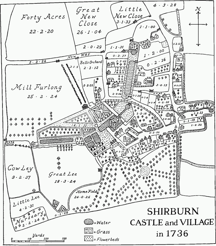
SHIRBURN CASTLE and VILLAGE in 1736
The above map is a simplification of part of an estate map by William Burgess.
In 1830 a fairly extensive modernization was undertaken—a drawing-room and library over it were added on the north side; the old north library over the hall was converted into a billiard room; the former drawing-room which had been over the dining-room on the east side was converted into a larger bedroom and a dressing-room; and the baths on the ground floor on the north side were removed. In 1870 the red-brick water tower adjoining the laundry was built and in 1873 the warder's room in the north-west tower and the low entresol above it were thrown into one to make a smoking-room.
The changes made during the 18th and 19th centuries in the surrounding grounds were equally spectacular. A map of about 1718 shows the castle and moat with a bowling-green and garden on the south-west side covering 5 acres. The church and home farm also lay to the south-west, and to the north was the kitchen garden. (fn. 44) The Great and Little Closes, Forty Acres, and Mill Furlong, lying north and south of the castle were at this date arable closes. (fn. 45) William Burgess's map of 1736 presents quite a different picture. (fn. 46) The first earl made many exchanges of land, mainly with the Tooveys, so as to be able to enlarge his pleasure grounds and divert the old public road. (fn. 47) In 1720 he made the large ornamental water, called Upper Duckery, and by 1722 Homefield (30 a.) and Mill Furlong (50 a.) had been laid down to grass and avenues of Dutch elms planted in Mill Furlong. The nursery was planted a few years later, (fn. 48) The Long Pond was made out of the one-time millpond: this marshy ground was purchased from Mr. Samuel Toovey on condition that the new 'pond' should not injure in any way Toovey's property. (fn. 49) The map of 1736 shows a formal garden to the north of the castle, and on the east a path running from the castle to a circular lake and temple. Two designs for a garden temple bearing the Macclesfield arms are in the Avery Library of Columbia University, U.S.A. They are attributed to the architect, John Sanderson (d. 1783?). The existing circular temple appears, however, to have been designed by Westby Gill of the Office of Works, for 'Mr. Gill' is referred to as the architect in letters from the London mason, Andrews Jelfe, relating to the supply of Portland stone for its construction in 1741. (fn. 50)
In 1739 the astronomer earl with the help of James Bradley built the observatory; (fn. 51) twenty years later the first part of the walled garden was made, the home farm was moved and in 1770 the churchyard was transferred from the north side of the church to the south side. (fn. 52)
Between 1780 and 1807 further improvements were made. Davis's map of 1790 shows the Dutch Elm Walk, the Terrace Walk, and the Clare Walk to the north and north-west of the castle; there was a new flower garden and Lower Duckery had been made. (fn. 53) From a map of 1807 a new orchard laid out to the north of the castle can be seen; the gardens to the south-west have been enlarged and now include a melon ground, and the ponds to the west of the castle have also been enlarged. (fn. 54) In these improvements a Mr. Ryston was the earl's adviser. (fn. 55) By 1819 the park was said to cover roughly 60 acres: it was not admired by Brewer in his guide who considered it 'too flat to afford much interest'. (fn. 56) Lord Torrington, writing earlier, in 1785, was even more critical of the park and also of the house. He found the castle 'melancholy and tasteless' in appearance and the place 'very ugly' and 'in very ugly country'. (fn. 57) But he was not in a position to give an unprejudiced view, for he had twice been refused admission, the second time after a 'tedious sultry ride of 16 miles'. Another contemporary view was that it was 'sublime' and left an 'irresistible impression on the soul of taste and sentiment'. (fn. 58) A conservatory of freestone and cast iron, and a pavilion for flowers were constructed early in the 19th century, (fn. 59) perhaps in anticipation of the royal visit in 1808 of the queen and princesses. The fine wall separating the park from the Lewknor road is mainly built of chalk and brick and is largely late-18th-century or early-19thcentury work.
The enlargement of the park and the inclosure of the open fields in 1806 led to great changes in the village. All the farmhouses below the hill once lay in the village and were mostly west of the Lewknor road and to the east of the castle. (fn. 60) In the mid-17th century there had been eleven farmhouses rated for the hearth tax, of which four had three or four hearths. (fn. 61) How many cottages there were is uncertain, but rentals show that there must have been many families which escaped taxation. (fn. 62) Village society had its clear distinctions of rank: in 1622, for example, Elizabeth Adeane left 12d. to every cottager of the town and in 1642 Richard Adeane left 12d. each to the four poor of Shirburn. (fn. 63) The estate maps of 1736 and 1780 show the farms and cottages mainly round the church and castle to the west of the Lewknor road. The pound was opposite Scole's farm, which lay on the corner of the lane leading to the church; the village cross was where the lane joined the Lewknor road. Several of the large farmhouses like Scoles's, Butt's, and Reading's had large orchards. (fn. 64) After inclosure the roads were fenced in and the cross was removed. New farmhouses were built: the map of 1807 shows Stone Hill Farm (later Model Farm) and Shirburn Farm to the north-west and north-east of the village, and Knightsbridge Farm in the open fields to the south-west. (fn. 65)
Judging from Brewer's strictures the cottagers were neglected. He noted that there were 'many huts of the most wretched description which act as offensive foils to the massive splendour of the neighbouring castle'. (fn. 66) The six derelict cottages now standing empty on the Lewknor road are probably characteristic of the 18th-century village: they are timber-framed and have partly brick and partly lathand-plaster filling. The roofs are thatched. Cottages and houses were restored or newly built in the course of the late 18th and 19th centuries. There is a row of fourteen pleasing cottages in Blenheim Road, a lane branching off the Lewknor road. (fn. 67) They were designed as a row and are mostly of two stories, but four have dormer windows; the material used is chalk with brick for decoration and for the chimneystacks. Two of the present-day cottages were once a bakery, but one is now used as a village shop. A group of houses facing towards the Lewknor road and inside the entrance to the castle stables are also built of chalk and brick and appear to date from the late 18th or early 19th century. In the mid-19th century a school was built. There has been no expansion in the 20th century: in 1960 there were reckoned to be 56 houses in the whole parish compared with 62 in 1811. (fn. 68)
The only houses of interest besides the castle are the castellated lodge on the Lewknor road, possibly built before 1805 by John Nash, who is known to have designed a cottage for the Earl of Macclesfield; (fn. 69) the early-19th-century West Lodge, which actually lies just in Pyrton; and Shirburn Lodge, an 18thcentury building, magnificently situated on the top of the Chilterns and overlooking the Oxfordshire plain through a glade cut in the woods. This last house was originally built by Joseph Collett of Hertford castle, who bought some of Shirburn's woodland in 1722, but was much altered after 1775 when the Earl of Macclesfield bought it back and it was used as a dower house. (fn. 70) It is constructed of flint with toothed brick quoins and window surrounds. The west front has three two-light dormer windows and five bays, the centre bay projecting slightly. The central door, with arched fanlight over it in an arched opening with stone key block, dates from the 19th century, when a wing was also added.
Although the position of the village at the junction of the route along the foot of the Chilterns with the route which went at right angles through the centre of Pyrton was strategically important, Shirburn seems to have played no important part in the conflicts of the Middle Ages. The value of its position was no doubt recognized by the Conqueror when he gave the village to two of his most trusted followers, Robert d'Oilly and Roger d'lvry, but there is no evidence that any Norman castle was built there. It has been stated that the castle was surrendered to the Empress Maud during the struggle against Stephen in the 12th century, but this mistake has arisen from a confusion with Sherborne (Dorset), which was surrendered by William Martel, (fn. 71) and another mis-statement that the insurgent barons met in 1321 under Thomas of Lancaster at Shirburn castle has arisen from a confusion with Sherburn-inElmet (Yorks.). (fn. 72) The lords of Shirburn were, however, certainly involved in this second struggle: Lord Tyeys paid for his part in the revolt against the Despensers on a York gallows and his brother-in-law, Warin de Lisle, was another rebel leader.
In the 16th and 17th centuries the Chamberlain ownership of the castle and manor made Shirburn a stronghold first of Puritanism, for Sir Leonard was at one time an ardent Puritan and an active despoiler of churches, and then from the time of Mary, of Roman Catholicism. Sir Leonard's second son George rebelled against Queen Elizabeth, fled abroad, and married a Dutch lady. Thus it happened that Shirburn was visited on the occasion of the funeral of Sir John Chamberlain in 1651 by their descendant, Dr. George Chamberlain, Bishop of Ypres. (fn. 73)
During the Civil War Shirburn was garrisoned for the king and some of Sir John Chamberlain's farm leases contain the provision that the tenant must fight for the king if called on. (fn. 74) In December 1644 Sir Francis Harrington wrote that the enemy intended fortifying 'a strong moated house belonging to Mr. Chamberlain'; and that he intended surprising it as it was then only held by eight men and two pieces of ordnance: 'it was 5 miles from Thame and the like from Wallingford, and could', he wrote, 'much straighten the town, cut off all provision from Thame . . . and shut up the passage to Abingdon'. (fn. 75) Parliamentary forces were in all the surrounding villages that year and 120 of their men taken by the royalists were imprisoned in Shirburn castle. (fn. 76) In August Sir Thomas Fairfax arranged an exchange and Major Massie, who was with him at Shirburn, planted five pieces of battery on the bowling-green, within a musket shot of the castle, and opened fire. He was said also to be making preparations to undermine it. (fn. 77) In 1646 parliamentary troops besieging Oxford again threatened Shirburn, and Mrs. Chamberlain petitioned Parliament for terms for the surrender of the castle. She claimed that the garrison had never annoyed the parliamentary forces in the past twelve months, but on the contrary had contributed provisions to the troops about Wallingford; that Mr. Chamberlain's men-at-arms in the house had prevented it from being an active garrison which would have much 'annoyed' Henley; that they only stood upon their guard to defend themselves from plunder and never took any prisoners or raised contributions from the country. The parliamentary comment on this was that 'if true Shirburn had been different to any other part of the country'. In June the 'House' was surrendered. (fn. 78)
From 1716 until the present day the Parker family has been resident at the castle and by 1900 the parish was entirely owned by it. Under the first two earls of Macclesfield Shirburn became a centre of scientific and literary renown. The Lord Chancellor, 'silver tongued' Parker, was described by Bishop Warburton as a 'real Mæcænas'. He was the patron of authors and founded the fine library (fn. 79) at the castle. Both he and his son were pupils and friends of William Jones, the mathematician, who lived at the castle as one of the family. The 2nd earl, (fn. 80) member for Wallingford 1722–7 and President of the Royal Society in 1752, took a keen interest in astronomy and spent much time at Shirburn studying under Jones. (fn. 81) With the aid of James Bradley he built in 1739 an astronomical observatory, where he trained two assistants, Thomas Phelps, the real discoverer of the Great Comet of 1743, and John Bartlett. One was originally a stable boy at Shirburn, the other a shepherd of Stoke Talmage. Together with the earl they made many observations. (fn. 82) The earl, besides being responsible for introducing the new style calendar, built a large chemical laboratory, (fn. 83) added greatly to the library and patronized the arts, (fn. 84) His eldest son, Lord Parker, contested Oxfordshire in the New Interest in the great election of 1754, an election which was notorious for the vast sums spent by both sides. Lord Macclesfield gave a feast to 300 freeholders of Watlington in 1752, establishing himself as the 'darling of all this part of Oxfordshire', and another in 1753. Oxford dons dubbed Lord Parker 'goody Bribery of Shirburn', and another of the cries of the opposition's supporters was 'give us back our eleven days'. (fn. 85) Four out of Shirburn's six freeholders voted for Parker and Turner: these included two Tooveys—Richard of Watlington and Samuel of Shirburn. (fn. 86)
As 3rd Earl of Macclesfield Parker made further additions to the library and by the time of his death in 1795 the six collections for which the library is famous had been brought together, and 12,700 or so printed books and 260 manuscripts had been assembled. The additions since his time have been negligible. It consisted of (1) the valuable collections of scientific works and letters collected by William Jones and bequeathed to the 2nd earl; (2) about 450 Bibles; (3) the Welsh collection of the Welsh antiquary, the Revd. Moses Williams, which was left to William Jones; (4) a large collection of books on linguistics; and (5) two important collections bequeathed to the 3rd earl. The first of the last two collections came from the Master of the Rolls in 1754, the second consisting of military works came from the Hon. George Lane Parker, the earl's brother. The library contains many first editions of early English books, including two Caxtons, and among its most valuable manuscript possessions is the unique Liber de Hida and many letters of Sir Isaac Newton. (fn. 87)
Amongst the portraits at Shirburn commissioned by the first three earls are one of Thomas, the 1st earl by Kneller; George, the 2nd earl by Hogarth and of his first wife by Kneller; of William Jones by Hogarth; and of Thomas the 3rd earl and his wife by Ramsay. This tradition of patronage of leading artists was followed by George, the 4th earl, who commissioned Ramsay to paint his wife Mary Frances. (fn. 88)
Manors.
In 1086 Shirburn was divided between two lords, two of the greatest tenants in Oxfordshire, Robert d'Oilly and Roger d'lvry, who were sworn companions in arms and had arranged to divide their spoils. (fn. 89) The latter held in chief a manor assessed at 10 hides and later sometimes called EAST SHIRBURN. (fn. 90) From the D'lvry barony the overlordship passed to the honor of St. Valery which was eventually attached to the Earldom of Cornwall. (fn. 91)
The mesne tenant in 1086 was one Ralph. (fn. 92) He may have been the father of Roger, who was the sonin-law of Drew d'Aundeley, tenant of the second Shirburn manor. Nothing further is known of him nor of the enfeoffment by which this estate was later held for 2 fees. (fn. 93) In about 1234–7 the overlord Richard, Earl of Cornwall, granted it to Henry le Tyeys in exchange for Grendon Underwood (Bucks.), to be held for the same service as Grendon. (fn. 94) This was presumably the agreement under which Shirburn's 2 fees and the manor were held like Grendon for the yearly render at North Oseney court of an ebony bow without string and 3 barbed arrows without feathers or 12d. (fn. 95) The Le Tyeys family, whose chief seat was eventually Chilton Foliot (Wilts.), held Shirburn during the 13th century. The Sir Henry le Tyeys (or Teutonicus) who held it in 1279, and was lord of Fritwell and Albury as well as of estates in several other counties, was presumably the son of the earlier tenant. (fn. 96) He had died by 1282, leaving an heir, of the same name, who was still a minor in 1284. (fn. 97) Sir Henry (III) le Tyeys, later Lord Tyeys, died in 1307. (fn. 98) His son Sir Henry, 2nd Lord Tyeys, was Keeper of Oxford city in 1311 and became one of the leaders of the revolt against the Despensers and a strong supporter of Thomas of Lancaster. His estates were forfeited and in 1322 he himself was hanged. (fn. 99) His heir was his sister Alice, widow of another rebel leader, Warin de Lisle, but she was not granted her brother's property until 1327. (fn. 100) Her younger son Henry, who took the surname Le Tyeys, (fn. 101) was perhaps granted Shirburn before his mother's death in 1347; (fn. 102) he certainly held it at his own death in 1361, (fn. 103) by which time he had acquired the 'manor of Burgfield', a half of the D'Oilly manor. (fn. 104) His heir was his nephew Warin, Lord Lisle, son of his brother Gerard. (fn. 105) Warin (d. 1382) left his estates to his only daughter Margaret, Baroness Lisle, wife of Thomas, Lord Berkeley, but Warin's widow Joan had a life interest in Shirburn manor (i.e. the D'lvry half) and in the 'manor of Burgfield' until her death in 1392. (fn. 106) Berkeley died in 1417, his heir being his daughter Elizabeth, wife of the powerful Richard Beauchamp, Earl of Warwick, guardian and tutor of Henry VI. On her death in 1422 her estates were divided between her three daughters and coheiresses, Margaret, Countess of Shrewsbury, Eleanor, Lady Ros, and Elizabeth, Lady Latimer. (fn. 107) In 1427 and 1435, however, Richard Quatremain of North Weston (fn. 108) bought their Shirburn property (i.e. three parts of the manor), (fn. 109) and in 1432 he acquired from the Collingridges (fn. 110) the fourth part of Shirburn manor and thus united the whole lordship under himself. Shirburn was not mentioned in Quatremain's will and had probably been granted already to his kinsman and friend Richard Fowler, Chancellor of the Duchy of Lancaster (d. 1477), although it is not mentioned in his inquisition post mortem. (fn. 111)
The chancellor's son Richard Fowler, who was a 'very unthrift' and became a pensioner of his mother Jane Fowler in 1501, gave Shirburn as security for a loan. (fn. 112) Sybil Chamberlain, the widow of Sir Richard Chamberlain of Woodstock and the daughter and chief executrix of Jane Fowler, who died in 1505, took possession of Shirburn manor in April 1505 as the debt was unpaid. (fn. 113) In May Richard Fowler, by now knighted, leased the manor to his sister and her son Sir Edward Chamberlain for 60 years. (fn. 114) and in 1527 Sir Edward obtained full rights over Shirburn by giving his uncle Tilsworth and Stanbridge manors (Beds.) in exchange. (fn. 115) On Sir Edward's death in 1542, he was succeeded by his eldest son Leonard, who added to the Shirburn property by buying land from Ambrose Dormer and the rectory and advowson from the Crown. (fn. 116) Sir Leonard who, like his father, had been Sheriff of Oxfordshire and Berkshire, died in 1561 leaving a life interest in the manor to his second wife Agnes. (fn. 117) As his son Francis Chamberlain predeceased Agnes in 1570, it was Francis's eldest son Robert (d. 1600) who succeeded. (fn. 118) Robert's heir, Sir Robert Chamberlain, was in a ship which vanished in the Levant in 1615 and the manor fell into the hands of the Crown for six or seven years until the death of Sir Robert became certain. (fn. 119) The Chamberlains were a Roman Catholic family and Sir Robert's next heir was his cousin, George Chamberlain, Bishop of Ypres, who renounced his claim in favour of John Chamberlain, the son of his brother Sir John Chamberlain. (fn. 120) This John Chamberlain died in 1651 leaving two coheiresses: Elizabeth, wife of John Nevill Lord Abergavenny, and Mary, wife of Sir Thomas Gage, Bt., of Firle (Suss.) and later of Sir Henry Goring, Bt. (fn. 121) There was a complicated division of his Shirburn estates by which the Abergavenny family had the manorial rights, the castle, and most of the rents and the Gages had the demesne subject to certain limitations. The woods and the rectory were divided equally. (fn. 122) The manorial courts were held for a group of trustees, called the lords of the manor, until 1659, but for Lord Abergavenny (d. 1662) in 1661 and in 1668 for his widow Elizabeth, Baroness Dowager of Abergavenny. (fn. 123) The date of Elizabeth's death is uncertain, (fn. 124) but it was before 1682 when her nephew Joseph Gage, the younger son of Lady Mary Goring, was in possession. (fn. 125) Joseph's son Thomas Gage sold Shirburn and Clare manor in 1716 for £25,696 8s. 5d. to Thomas, Baron Parker (d. 1732), the eminent lawyer and Lord Chief Justice, later Lord Chancellor and 1st Earl of Macclesfield of the second creation. (fn. 126) The manor has remained in the possession of the earls of Macclesfield until the present day.
George Parker (d. 1764), the 2nd earl, was succeeded by his son Thomas Parker (d. 1795), the 3rd earl, and by his grandson, George Parker (d. 1842), President of the Board of Agriculture (1816–18) and Lord Lieutenant of the county. The 4th earl's only son died in infancy and the title and estates were inherited by his brother Thomas Parker (d. 1850), 5th earl, and after him by Thomas Lord Macclesfield (d. 1896), who was succeeded by his grandson George Lord Macclesfield, 7th earl and the present owner. (fn. 127)
In 1086 Robert d'Oilly, the Constable of Oxford castle, held a second manor, assessed at 10 hides and later sometimes called WEST SHIRBURN manor. (fn. 128) The overlordship, like that of Bucknell and the mesne tenure of South Weston, descended with the D'Oillys until 1232 when it was inherited by Thomas de Newburgh, Earl of Warwick, who was returned as overlord in 1242; (fn. 129) it passed to the Plescys, who were overlords in 1279, 1349, and 1361, (fn. 130) but after 1361 their tenure was no longer mentioned and by 1428 this Shirburn manor was said to be held directly of the king. (fn. 131) The estate was reckoned as 2 fees in the 13th century. (fn. 132)
The tenant in 1086 was apparently Drew d'Aundeley, the D'Oilly tenant also at Ardley under the earls of Chester, at Hardwick and at South Weston, but his family do not seem to have succeeded him at Shirburn, though the connexion with tenants of the honor of Chester remained unbroken. (fn. 133) By the mid12th century the lord of this part of Shirburn manor appears to have been Roger Fitz Alfred, for he gave the mill and apparently also the church to Dorchester Abbey. (fn. 134) He can be identified as the son of Alfred de Cumbray, lord of Lee Cumbray (Shrops.), who may himself have been in possession of Shirburn lands, since an Alfred of Shirburn. witnessed an Oxfordshire charter of Robert d'Oilly about 1139. (fn. 135) The Cumbray family were prominent tenants in the 12th century of Chester honor in Cheshire, Derbyshire, and Oxfordshire. (fn. 136) Roger Fitz Alfred's other Oxfordshire estate was at Pishill and he is probably the Roger Fitz Alfred of Shirburn who witnessed a local charter about 1158. (fn. 137) Alive about 1186 to 1194, (fn. 138) he must have died in the next decade when his Oxfordshire property seems to have descended to one of his younger sons, Ralph Fitz Roger, who in 1204 gave dower in Pishill and Shirburn to Roger's second wife Maud de Frodsham. (fn. 139) As at Pishill, the Fitz Alfred's land in Shirburn or rather a portion of it, for there were two tenants of the D'Oilly manor in the 13th century, went eventually to the Duttons, descendants of Roger Fitz Alfred's daughter Agnes, who married Adam de Dutton, Seneschal of the Constable of Chester and a prominent Cheshire landowner in the late 12th century.
In 1242 Sir Robert de Burghfield, the demesne tenant, was returned as holding the whole D'Oilly manor for 2 fees, but in 1279 his descendant was holding 1 fee and Sir Geoffrey de Dutton the other. (fn. 140) Sir Robert came of a Berkshire family whose seat was at Burghfield (Berks.), where the family can be traced from the 12th century. (fn. 141) His son and heir was probably Sir Roger de Burghfield who was holding some 15 virgates of land in 1279. (fn. 142) At this time the second D'Oilly fee and about 14 virgates were held by Sir Geoffrey de Dutton. (fn. 143) The Duttons were a Cheshire family whose ancestor Adam de Dutton had risen to prominence as a Cheshire landowner in the late 12th century, partly through his acquisition of much of Roger Fitz Alfred's property. (fn. 144) It is not certain when exactly they acquired a knight's fee in Shirburn, but it would appear to have been between 1242 and 1279. It is unlikely that the Duttons resided in the parish, but the Burghfields certainly had a manor-house, where their tenants did suit. (fn. 145) Sir Roger de Burghfield, knight of the shire for Oxfordshire in 1305 and 1306, did not die until 1327, (fn. 146) and was returned as joint lord in 1316 with John de Lewknor, the Duttons' successor. (fn. 147) In 1346 Peter de Burghfield, Roger's brother and heir, was in possession. (fn. 148) Shortly after the 'Burghfield manor', a quarter of Shirburn manor as it was sometimes called, was sold to Henry le Tyeys, who was returned as tenant of the D'Oilly fees in 1349. (fn. 149) The descent of this estate then followed that of the Le Tyeys manor to the Quatremains. (fn. 150)
In the meantime the Dutton half of the D'Oilly manor had been sold to the Lewknors. Sir Geoffrey de Dutton died in or before 1279, (fn. 151) but in 1275 he had already leased most of his Shirburn property for six years to John, son of Adam de Lewknor, lord of Wormsley in Stokenchurch (then in Aston Rowant), and soon after his son Sir Peter de Dutton granted land there with the dower of his mother Isabel de Dutton, when it fell in, to Master Robert de Lewknor. (fn. 152) Master Robert seems to have been acting for John de Lewknor's son Robert, and as nothing further is heard about the Duttons in Shirburn this grant presumably conveyed their entire holding. The Lewknors were a widespread Oxfordshire family, but the Shirburn tenants can be identified with the Lewknors of Wormsley, Heythrop, and Dean and Chalford. (fn. 153) John son of Adam de Lewknor bought up other property in Shirburn (fn. 154) and his son Robert laid the foundations for the family's fortunes before his death, some time after 1331. (fn. 155) His son and heir was John de Lewknor, sheriff and keeper of Oxford castle in 1333 and member for the county, who was granted free warren in his Shirburn demesne lands in 1336 and returned as co-parcenor of the Shirburn fee in 1346. (fn. 156) He died before 1356 when his son Sir John (d.c. 1381) held Shirburn, defined as ¼manor, (fn. 157) the Tyeys manor consisting of the other three-quarters. (fn. 158) The estate was settled on his wife, Elizabeth, who took it to her second husband, Sir John de Manning, (fn. 159) but he was outlawed in 1390 and the king seized the property. Elizabeth was not able to obtain possession until 1395, two years after Manning's death. (fn. 160) In 1401, with the assent of her son and heir, Robert de Lewknor, she granted the Shirburn 'quarter manor' to Bartholomew Collingridge, a Buckinghamshire landowner. (fn. 161) By 1417 Collingridge evidently farmed a considerable amount of the property in Shirburn including land of the other manor, but in 1432 he granted his Shirburn manor to Richard Quatremain, apparently as the result of a lawsuit, for much later in about 1460 Quatremain denied that he had obtained it 'by feigned means' and said that Justice Cottesmore had awarded him the manor to be held by Collingridge for £10 a year. (fn. 162) The manor henceforth was included with Quatremain's other manor.
Lesser Estates.
At the end of the 12th century Roger Fitz Alfred granted a ½-virgate to John Fitz Alfred Brokepenny, who was perhaps his illegitimate brother. (fn. 163) A John Brokepenny was mentioned in 13th-century charters (fn. 164) and it was probably he or a son who in 1279 held land of the Le Tyeys estate and who had a court for his tenants. (fn. 165) He married Agnes the daughter of John, son of Adam de Lewknor, and was probably succeeded by his son Henry Brokepenny in the 14th century, who was followed by John Brokepenny. (fn. 166) The family descent has not been traced further in this century, but 'Brokepenny Place' was purchased by Richard Quatremain in the 15th century from Thomas Barbour and his wife Elizabeth, daughter of a John Brokepenny. (fn. 167)
In 1279 Ralph the carter held 1 virgate of the Earl of Cornwall for suit at North Oseney court and for summoning there the men of the honor of St. Valery from Shirburn, Stoke Talmage, and Baldon. (fn. 168) He can be identified with Ralph of Watcombe, who in 1292 granted a half of this virgate to Nicholas Lovett; he had probably already granted half to Hugh de Pusemere (Paskemer). (fn. 169) It seems that this virgate was held for 1/10-fee, for in 1300 Nicholas Lovett and Hugh de Pusemere were returned as tenants of 1/10-fee which had been held by William of Shirburn, who may have been Nicholas's father. (fn. 170) The virgate and 1/10-fee cannot be traced in later records.
Mill.
No mill was recorded at Shirburn in 1086, but in 1163 the Pope confirmed the gift of a mill there to Dorchester Abbey. (fn. 171) In 1432 a William Cayme was tenant of the mill and a close called Millheys and paid 2s. a year and suit of court. (fn. 172) After the Dissolution the abbey's former close and fishery called 'Le Mille Ponde', held by the tenant Richard Emery, were granted in fee to Roger and Richard Taverner in 1545. (fn. 173) By 1573 the mill had been united with the manor, (fn. 174) but appears to have soon gone out of use, if it had not already done so by 1573. In 1601 the site, where a water corn mill 'lately stood', is mentioned. (fn. 175) The mill was evidently rebuilt by the Chamberlains, for in 1631 the vicar complained that it had been built since the composition over tithes had been made in the 1570's and that the miller paid no tithes of grist. (fn. 176) In c. 1646–8 William Turpin had the mill at a rack rent and later it appeared among the demesne lands at a rent of 11s. (fn. 177) In 1649 Thomas Rose, yeoman of Pyrton, agreed to pay John Chamberlain, lord of the manor, £1 a year so long as Chamberlain allowed him to make a dam on the stream coming from Shirburn mill. (fn. 178) Leases of 1637 and 1651 insisted that corn should be ground at Shirburn mill. (fn. 179)
Agrarian and Social History. (fn. 180)
The soil of Shirburn is fine loam below the hills and flint and clay on the Chilterns with a sub-soil of chalk, and many streams account for the excellent meadow land in the northern part of the parish. (fn. 181) There is no archaeological evidence for early occupation, but neighbouring parishes were certainly settled in the early days of Saxon settlement (fn. 182) and Shirburn is not likely to have been passed by.
In 1086 there were two estates in Shirburn, one belonging to Robert d'Oilly, the other to his sworn companion Roger d'lvry, but this manorial division must have been later than the laying out of Shirburn's fields. All the evidence indicates that there was never more than one set of open fields and this system must have been too firmly established to be affected by manorialization. The manors were sometimes called East and West Shirburn in the medieval period, but this seems to have arisen from the position of the manor-houses (fn. 183) and in no way from the location of their land. The two estates were similar in many respects in 1086: they both had land for 6 ploughs, 20 acres of meadow, and 30 acres of pasture, but the D'lvry manor had 50 per cent. more woodland than the D'Oilly manor. The D'Ivry manor (i.e. East Shirburn) was also more valuable than the other, being worth £7 as against £6, but both showed a considerable rise in value since before the Conquest when they were each worth £4. There were 4 serfs, 13 villani, and 3 bordars on the D'lvry manor and 12 villani and 7 bordars on the D'Oilly manor. Both manors were a little overstocked: the customary tenants of one had 5 ploughs and those of the other 4½ ploughs; there were 2 ploughs on each demesne making a total of 13½ plough-teams for the estimated 12 plough-lands. (fn. 184) It must be supposed that in the 11th century much more of the parish was woodland than it was later, and that the peasants were increasing the area of cultivation. It is perhaps significant in this connexion that Shirburn was assessed at 15 carucates in 1220. (fn. 185)
The hundred rolls inquest of 1279 throws an interesting light on the developments in tenurial organization and its effect on the extension of cultivation. The most striking change is the existence at this date of a predominant class of freeholders, an unusual feature in many Oxfordshire villages, but a characteristic of this Chiltern area. In 1086 there had been 35 customary tenants, but in 1279 only 17 were recorded, a decrease which was offset by the appearance of about 45 free tenants. (fn. 186) The evidence of the numerous charters preserved at Shirburn castle indicates that most of the persons transacting them lived and farmed in Shirburn, (fn. 187) and that the population at the end of the 13th century may have been as great as it was in the mid-19th century, and certainly greater than it was in some of the intervening centuries.
A considerable increase in cultivation took place between 1086 and 1279. About 78 field virgates are mentioned in 1279, (fn. 188) and it is possible that the limits of cultivation had been reached. There were 21 virgates in demesne on the three manors, 14½ virgates of customary land, and about 48½ virgates held by free tenants. Some of the newly cultivated land was on the hills: there are references in 13thcentury charters to crofts ultra montana. (fn. 189) This progress in cultivation is borne out by the evidence of the tax lists. At the reassessment of 1344 Shirburn's total tax was raised. (fn. 190) Much of the parish was, however, still covered in wood and rough pasture land. A part of this, 100 acres of wood and 40 acres of waste, was inclosed as a park by Alice de Lisle in 1336. (fn. 191)
There were three principal manors in Shirburn in 1279, the D'lvry manor of East Shirburn, now belonging to Henry le Tyeys, and two parts of the D'Oilly manor of West Shirburn, now divided between Sir Roger de Burghfield, who had a manorhouse in Shirburn, and Sir Geoffrey de Dutton. (fn. 192) The East Shirburn manor had a demesne of 12 virgates, 15 villein tenants holding 14½ virgates, and 18 free tenants. At West Shirburn Sir Roger de Burghfield had 5 virgates in demesne, 2 villein tenants, paying money rents, and 21 free tenants; Sir Geoffrey de Dutton had 6 virgates in demesne, no recorded villeins, and 16 free tenants of whom only one held as much as 2½ virgates and one held only a cottage. One of his free half-virgaters, besides paying 10s. rent, owed the same services as the villeins on 'the other part of the fee', i.e. the Burghfield fee.
There were 15 virgaters and half-virgaters on the Le Tyeys estate. Eleven of these owed quite heavy works and a virgater paid 20s. rent if his works had been excused, but if he had to work he paid only 3s. 9d. rent. For his works he had to work with 1 man every other day between the feast of St. John the Baptist (24 June) and St. Peter-in-Chains (1 Aug.) and every day except Saturday from 1 August to Michaelmas, over the harvest time, at the lord's expense. He mowed a ½-acre for his own work and pro dieta sua and ploughed a ½-acre for garserthe. His extra dues at harvest time included providing 2 men for 2 bedrips. At Christmas he had to cart one load of wood, but could have one load for himself. He and his fellows were given pro medses a sheep, sacks of salt and oat flour (? meal), and a cartload of wood to cook their food. He paid half a quarter of oats for churchscot, ¼d. for pannage for every yearold pig except his sow, and he had to pay for permission for his daughter to marry. The lord allowed him to have one horse and one ox or calf without special permission. If he was reeve the lord provided his meals over the harvest time. The greater part of the account in the hundred rolls is concerned with the free tenants. These tenants, about 50 in number, (fn. 193) varied widely in status and possessions; one, John de Brokepenny, held 7 virgates and had under-tenants who did suit to his court, but many others had very small holdings and may, economically, have belonged to the cottar class. Most of them paid money rents of varying amounts, sometimes as much as 20s. for a virgate, though two, of which one was John de Brokepenny, were described as holding per antiquum conquestum and paid no rent. Most owed suit to the manorial courts and in some cases suit to the hundred court of Pyrton is specifically mentioned. Two tenants held directly from the honor of St. Valery and owed suit to the honor court. Several tenants had tenants holding under them.
Over 100 peasant charters, ranging from c. 1250 to 1427, have survived. They deal usually with quite small parcels of land, showing how the holdings were built up in a piecemeal fashion. Some of the charters were in the nature of family settlements: in 1351 for example, Adam, Vicar of Shirburn, granted John Brokepenny and his wife Alice the lands which he had previously received from John. (fn. 194) Many families, whose properties were much smaller than the Brokepennys', such as the Levelifs and Dovers, executed similar conveyances. (fn. 195) In several cases provision was made for brothers or daughters: John Apselan granted his daughter Emma 7 acres of arable and a ½-acre of meadow which was to revert to himself if she died without heirs. (fn. 196) The principal families who appear in these charters are those of Apselan, Brokepenny, Lewknor, De Camera or Chamber, and Hamuldene, but there are many other names which appear several times as parties to the conveyances or as witnesses. The more substantial freeholders ranked next in the community to the lords of the manors; in 1316 William de Camera and John Apselan paid 6s. and 5s. 4d. respectively towards the tax, while Henry le Tyeys paid 12s. 6d. (fn. 197) Gilbert atte Ewychine, who paid 16s. to the subsidy of 1306, appears only once in the Shirburn records as the grantor of a ½-acre to Nicholas Lovett. (fn. 198)
The impression left by these charters is of a close and vigorous community in the 14th century, but their numbers and importance were declining in the early 15th century when Richard Quatremain, who had united the Shirburn manors, bought in several freeholds. A survey of the manor made for him in 1432 records that he had obtained by purchase or exchange the lands of seven free tenants, including Hamuldene's, Dover's lands, and Brokepenny's Place, amounting to 19 virgates or over, as well as the fourth manor of Shirburn (or 'quarter part'), which had formerly been held by Sir John Lewknor. (fn. 199)
In many cases the land was leased or held freely by sub-tenants and Richard Quatremain would only receive the rents, but in one case, that of 1 acre held by Nicholas Jaket, it is recorded that after his death his heir would not claim it (disclamat tenere), and it accordingly escheated to the lord. (fn. 200)
In 1432 there were about 32 virgates held by 19 free tenants, many of them holding two or three separate portions from the different manors. The largest holding was that of Peter Fennell alias Jay, who held 9 virgates, 3 in Shirburn manor, 3 in the lands bought from Thomas Chebenhurst, whose ancestor John appears as mesne lord of 1 virgate in 1279, and 3 in Walyngford's land, another freehold bought by Richard Quatremain. Other free tenants also held land as customary tenants. (fn. 201)
A court roll of 1419 of East Shirburn manor, then held by the Countess of Warwick, shows how rapidly the tenants changed in the first half of the 15th century. (fn. 202) Of the twelve free tenants holding land in 1419 only half appear again in the 1432 survey. (fn. 203) Only three of all the names in the 1432 survey appear again in a court roll of 1493 which contains 29 names. (fn. 204)
The court roll of 1419 is of considerable interest as it gives the terms on which the customary tenants held their land. Ten holdings amounting to about 15½ virgates are described and of these all but one tenant was said to be taking up all, or part, of his land anew. The number of new tenants is in itself unusual; in the previous two court rolls there were only two admissions, one of which suggests a possible explanation of the large number of admissions in 1419. In 1418 John Hendy succeeded his mother in two parcels of land, one above the hill and one below, and paid no fine. In the next year he took up de novo the ½-virgate which lay below the hill, paying 3s. 4d. fine, to hold for his life and that of his wife. All the other admissions in 1419 are for several lives, one is for eight lives, and it may be that the other admissions were also not of new tenants but of new lives. The highest fines paid were 20s.; in one case the tenant had licence to sublet and in another it was agreed that although the land was to be held for two lives only one heriot should be paid. By 1432, however, only four of the ten tenants who are mentioned in this roll were still holding land as customary tenants. (fn. 205)
There were 38 families holding land in Shirburn in 1432, less than in 1279, and there may also have been some decrease in the area of arable cultivated, (fn. 206) but this is difficult to assess as there is no indication of the size of the demesne at East Shirburn at this date. The description of the demesnes of Lewknor manor (i.e. part of West Shirburn) in the 1432 survey is of interest—quarta acra per totam terram dominicalem domini de Shirburn iacens tarn in campis et clausis (fn. 207) — and it may be that the demesne lands had lain in one block, which was divided up between the manors. A 16th-century lease of land which was almost certainly former demesne describes it as '200 acres in the fields of Shirburn from Northstoke way to Baymys (Kaymys) Way and so round about the town to Watlington Way, one piece adjoining to another'. (fn. 208) Field names, as was often the case, were liable to change constantly, but early undated charters and the lie of the land suggest that there may have once been only two fields; Barnescroft and Witcroft Fields are mentioned in two charters, North Field and 'the field towards le Doune' (i.e. South Field) occur in another. (fn. 209) North, South, and East Fields are mentioned in other charters, and there were clearly three fields by the late 13th century in Shirburn-below-the hill. (fn. 210) The open fields evidently extended beyond the Icknield Way, which roughly bisected the parish, for Downfurlong was said to lie above the Icknield Way. (fn. 211)
Eighteenth-century maps also show that the open fields extended in the south-east beyond the Icknield Way. The names of the furlongs here are significant: Sheep Hill, Warren, Long, Short, and Middle Slade, and Wood furlongs. (fn. 212) There were about 1,500 acres below the hill out of 2,400 in the parish. (fn. 213) There were also cultivated areas on the wooded hills: Henry le Tyeys granted John son of Adam of Lewknor a messuage supra montano campo Bokendene; three crofts at Bugendeneshaved and three crofts called Iteyrnsfeldes also occur. (fn. 214) There are references to other fields such as Pykefeld, which had belonged to Sir Hugh de Berwyk, and is probably the 40 acres known in the 17th and 18th centuries as Berrick's closes. (fn. 215) There is no mention, however, of furlongs or cultura above the hill and it is likely that all the arable in this area was always inclosed.
Three 17th-century terriers give more details of the open fields. By then there were four fields, but two of these, Long Slade Field and Water furlong, described as lying one above the town and one below, were cropped as one field. The other two fields were called at this date Stonehill Field and Hungerbrook Field, and these names persisted into the 18th century. (fn. 216) A terrier of 1716 refers also to Upper and Lower Fields, (fn. 217) apparently alternative names for Long Slade and Water Furlong Fields.
The meadows and cow common in the medieval period lay where they are shown on the estate map of c. 1718, along the stream dividing Shirburn from Stoke and Clare. The cow common covered 23 acres in the 18th century, and both Spear Bottom and the Common are described in early charters as lying near Knightsbridge. (fn. 218) The only other pasture in medieval Shirburn was the rough pasture on Shirburn Hill beyond the Icknield Way. The field names Lynhull, Flax Hill, and Scrubfurlong show that flax was cultivated and confirm what is known of the early conversion of woodland into arable, (fn. 219) but otherwise throw no light on agricultural practice. From the charters it is evident that the peasant land was little consolidated at the end of the 13th century: in a grant of 9 acres of arable the land lay in 22 separate parcels of ½-acres and rods. (fn. 220) The virgate seems to have consisted of 16 acres as at Pyrton. (fn. 221)
The only mention of stints in the medieval court rolls occurs in 1493, when it was agreed that no more than 25 sheep from each virgate should be put on the common pasture. (fn. 222)
The chief clue to the changes in village society in the late medieval period is provided by the subsidy list of 1523–4. This reveals a remarkable concentration of wealth in the hands of one yeoman family, the Frankleyns: of a total tax of £8 12s. 2d. William Frankleyn paid £4 10s., John Frankleyn 10s., and Sybyl Frankleyn, widow, £2 10s. There were sixteen other small contributors. (fn. 223)
At the end of the century the Adeane family, related to the lords of Britwell, were among the richer members of the community. (fn. 224) Richard Adeane, a husbandman, had goods worth over £116 in 1599, and Elizabeth Adeane, a freeholder, had goods worth £132 in 1622. (fn. 225) A poor relation, William Adeane, however, left only £8 16s. worth of goods in 1599. (fn. 226)
Court rolls, leases, and wills throw a little light on the husbandry of this period. The demesne farm consisted of 10 yardlands. It was allowed a stint of 240 sheep in 1545, rather less than the earlier rate of 25 to the virgate agreed on in 1493, but the stint was increased to 300 in 1566. (fn. 227) Another farm was of 4 yardlands and with it went a number of closes above the hill and common for beasts in the wood. It was held by a Haseley yeoman, who leased it. (fn. 228) In 1534 he was in financial difficulties, for he mortgaged it to Sir Michael Dormer. (fn. 229)
A rent roll of 1642 of the Chamberlain estate gives a clearer picture. The demesne farm was then leased at three times the rent of each of the five next largest farms, all let at about £20 for the half-year. (fn. 230) Besides these principal farms there were four other farms with rents ranging from £6 to £16 a year, and 24 tenants holding cottages or very small holdings, paying £4 and under in rent. There was also a mill. (fn. 231) Leases of this period show that services were still exacted: 2½ yardlands leased to Henry Stevens, for example, required one day's employment from him with a team for every yardland and other duties. He paid a fine on entry of £80. (fn. 232) On the tenant farms the emphasis at this date seems to have been mainly on arable crops. When Stevens' father died in 1636–7 his crops were worth £62 11s. and his stock was valued at £26 6s. (fn. 233) Another tenant, Thomas Gadbery (d. 1633), had crops and stock of about equal value. (fn. 234) Neither of these men had any sheep at the time of their deaths. Elizabeth Adeane and William Leveridge (d. 1629) on the other hand had flocks of 84 and 6 respectively, though in each case the value of their crops was nearly three times that of their stock. (fn. 235)
These inventories demonstrate how well off the principal farmers were at this time. The total valuation of the goods of John Stevens, including debts due upon bond of £19 10s., was £143; that of William Leveridge, another tenant, was £174. (fn. 236) Farms were rather above the usual size for South Oxfordshire. Leveridge had 95 acres of arable, Stevens 90 acres, Gadbery 80 acres, three of the Scoles family had 220 acres between them, and one tenant had as much as 120 acres. (fn. 237) These comparatively large farms meant, however, that some husbandmen lost acres and that farms were eventually reduced in number. It was indeed one of the vicar's complaints in 1647 against John Chamberlain that he had taken into his demesne farm many of the husbandmen's acres so that they could not keep so many sheep and beasts as before. Chamberlain, however, denied the charge and pointed out that no commons had been inclosed. (fn. 238)
Sir Leonard Chamberlain followed the contemporary fashion and inclosed land: a lease of 1545 contains the provision that the tenant should inclose with ditch and hedge 40 acres. (fn. 239) In the early 17th century there is evidence of much inclosure on the hill. From a lease of 1607 of a farm there of 200 acres it appears that it was all inclosed, but how much of this was medieval inclosure and how much 16th-century it is impossible to say. (fn. 240) A lease of 1651 of the demesne farm (160 a.), 'as it is now set out in several pieces', indicates that it was all inclosed, and that some at least of it had been recently inclosed. (fn. 241) An estate map of 1718 shows the position of the inclosures below the hill: there were some closes in the north of the parish (35 a.) and about 120 acres surrounding the castle on the north, east, and west sides. (fn. 242) There are many indications that John Chamberlain, before he was overtaken by the disaster of the Civil War, had been an active and progressive landlord. The reorganization of his estates led him into various disputes with his neighbours: inclosures in Clare and on the demesne in Shirburn were no doubt responsible for the boundary disputes with Edmund Symeon of Pyrton in 1636. (fn. 243) Other disputes arose out of Chamberlain's efforts to improve the value of his woods and to inclose land on the hill. (fn. 244) One with Robert Scrope, lord of Wormsley, was settled by agreement in 1620. (fn. 245) In 1662 the land in dispute contained 74 acres of arable, 73 of pasture, and 143 of wood in fourteen parcels, and though it may be that the inclosed land already existed in 1620 there is little doubt that Scrope had profited by the recusancy of John Chamberlain to increase his holding here in the intervening years. (fn. 246) The vicar's complaints in 1647 about his loss of tithes mention other inclosures—the holdings of Lucies, Hopkins, and Stevens and others, and refer to inclosures of woods which had formerly been common. Loss of grazing rights in these woods meant that he received only 2 todd instead of 5 or 6 todd of wool from his parishioners. Chamberlain's reply to the complaint about closes was that he 'was not to be hindered from directing such husbandry amongst my tenants as I think convenient for them and me'. (fn. 247) The vicar's claims were no doubt exaggerated but it seems that the demesne farm had been converted into a dairy farm and immensely improved in value. The vicar alleged a rise in value of the small tithes from £2 to £20. Chamberlain professed to be unable to understand this claim, but the inventory of Thomas Reading, a tenant of the demesne farm at the end of the century, perhaps explains what had been happening. He had 100 cheeses in store. (fn. 248) The London market, easily accessible by barge from Henley, (fn. 249) may well have been the destination of Shirburn cheeses and butter.
The Civil War was a 'troublesome' time for tenants as well as landlord: Chamberlain's royalist sympathies and the strategic position of his castle, which was fortified for the king, brought the parish into the battle area until the castle was surrendered in 1646. (fn. 250) The estate was then sequestered on account of the recusancy of the Chamberlains and suffered all the ills arising from an absentee landlord. Documents at Shirburn reveal some of the local consequences of these disturbances. Two leases to the chief farmers in the parish of 1637 require the tenant 'to give his whole strength with John Chamberlain in time of war' on the king's side. (fn. 251) During the war rents were abated on account of contributions to the king's army and 'other the like extraordinary taxes'. (fn. 252) In addition there was the burden of quartering soldiers. (fn. 253) Rents became very difficult to collect: arrears of rent from the Shirburn estate at Michaelmas 1643 amounted to £128, and in this account £133 4s. was allowed for defalcations; (fn. 254) on Lady Day 1646 the year of the surrender to General Fairfax, only £45 13s. was received out of £134 4s. due. £75 5s. had been remitted for 'payments' made by the tenants and some not yet allowed for were 'cast off from the account as not to be recovered'. (fn. 255) At this period there were fourteen farms let 'at or near the racke rent' for £203 a year, about 100 acres of demesne let to ten tenants, eight other farms or tenements let at small rents for life or at will, probably on beneficial leases, and four small quit rents from small holdings. (fn. 256)
On John Chamberlain's death in 1651 the estate was divided between his two daughters, Dame Mary Gage and Lady Elizabeth, the wife of John, Lord Abergavenny, who compounded for two-thirds of the estate. (fn. 257) By 1685, however, Lady Abergavenny was so heavily indebted to Samuel Toovey of Wormsley that she was obliged to sell him about 390 acres for £2,850. (fn. 258) In 1716 Joseph Gage, by then sole owner of the manor, sold to Lord Parker.
The price paid for Shirburn, apart from the castle and its grounds, was 23 years' purchase of an annual value of £493 11s. 2½d. (fn. 259) There were seventeen tenants, but nine of them paid small quit rents amounting to £1 4s. 8½d. only. Most of the other rents were small, the largest being £31 and £32 from John Scoles and Thomas Reading and £150 from Thomas Blackall. The Scoles and Stevens and two other families, who had been tenants in the mid-17th century, still had their farms. (fn. 260) An estimate of improved values was made in 1722 which proposed an increase in rents from £493 to £815; this included £200 for the castle, orchards, and gardens. (fn. 261)
The manor purchased by Lord Parker was a good deal smaller than it had been in John Chamberlain's time when the whole parish except for a little woodland was in his possession. (fn. 262) The rentals of 1646–8 give no acreages so that the exact extent of the estate at that date is not known, but it is most likely that the alienations took place after the Civil War, particularly of woodland, then so much in demand. During the 18th century the earls of Macclesfield, as the Parkers had become, gradually bought up land in the rest of the parish as well as outside it and greatly improved the estate. An estate map of 1718 shows what Lord Parker first purchased. It consisted of about 440 acres, or rather over one-third of the land below the hill. The land above the hill was mostly owned by others. Below the hill there were six tenant farms on the estate besides the demesne. (fn. 263) From a map of 1730 various developments can be traced. The total amount of land in the manor was then 536 acres, including cow leys, waste land, and baulks in the fields. Of this land 247 acres was inclosed, mostly on the Home farm, which had only 32½ acres of common arable out of 163 acres. There were three other tenant farms of average size: Reading's (75 a.), Messenger's (73 a.), and Bavin's (78 a.). There were fourteen other proprietors of which six held very small amounts of land. Of the four fair-sized farms (110–140 a. each) two were held by Mr. Thomas and Mr. Samuel Toovey and two by the Revd. Matthew Haws and Mr. Henry Haws. The total amount of freehold land was 692 acres, of which 624 lay in the open fields. The manor was rated at 39¾ yardlands and the rest at 55½. Although much of Toovey's land was not inclosed a considerable amount lay in compact blocks of 20 to 26 acres. (fn. 264)
From 1770 on extensive purchases were made, particularly of woodland. Toovey's property, bought in 1770, consisted of 160 acres below the hill and closes on the hill. (fn. 265) As a result Portobello farm on the hill was created. There were still thirteen proprietors, two of them owning woodland as well as arable land, but the smallholder was disappearing. He had been replaced by cottagers, of which there were now 50 families. (fn. 266) When the inclosure award was made in 1805 there were only three freeholders left in the open fields—the earl, William Scoles, whose family had been farmers in the parish since at least 1646, and the vicar. The area to be inclosed amounted to 1,173 acres of which Lord Macclesfield received 1,069. (fn. 267) In the tithe award of 1841 the total arable area was 1,828 acres, so that old inclosures probably amounted to about 650 acres. There was a fourth freeholder at this time, John Fane of Wormsley, but he held wood and land on the hill only. (fn. 268)
During the 19th century Lord Macclesfield's estate was exceptionally well farmed; his dairy of Devon cows, his teams of Devon oxen, which he found more profitable than horses as they never had to be fed on corn, and his good South Down flock were noted by Arthur Young in 1809. (fn. 269) Later in the century another agricultural expert observed that 50 acres or so of meadow in the park were irrigated and were among the few water meadows in the county, rivalling Blenheim Park. (fn. 270) Farms on the estate were large by Oxfordshire standards, particularly the Home farm, and after the creation of new buildings in 1857 Lord Macclesfield acquired a reputation as one of the leading experimental farmers in the country. The new buildings designed by Mr. Wilkinson of Oxford were described in the Illustrated London News as a 'valuable model', worthy of imitation, and they at once attracted visitors from all parts of the country. The covered ways and covered yards were a special feature; the yards provided dry accommodation for cattle and for the storage of manure. It was intended to lay a tramway in the covered way by the straw barn so that ricks from the rick-yard might be brought in whole to the thrashing machine. The machinery was another notable feature: there was Clayton and Shuttleworth's combined thrashing and winnowing machine and Messrs. Nasmyth's 12 h.p. steam-engine and boiler. The machinery was used for an exceptional variety of purposes, for crushing oats and beans, grinding corn, sawing timber, cutting chaff, thrashing, and for drawing water from a deep well to supply a cistern from which the water was conveyed by iron piping throughout all parts of the homestead. (fn. 271) In 1867 this farm, then known as Model farm, consisted of as many as 615 acres, of which just under half was arable. It employed 26 labourers, four of them boys between 13 and 18, and 5 women. (fn. 272)
Lord Macclesfield also took good care of the woodland which was all bought back and reunited with the manor by 1900. (fn. 273) It had always formed a large part of the parish: in 1086 3 × 1½ furlongs were recorded on the D'lvry manor and 3 × 1 furlong on the D'Oilly manor. (fn. 274) In 1279 40 acres of demesne woodland were recorded on each of these estates, by then split up between three tenants. (fn. 275) Court rolls of the 15th century indicate the importance of common rights in the woodland. (fn. 276) In the 17th century woodland occupied about a third of the manor. (fn. 277) Beech, oak, and ash were the chief trees: these are listed in a lease of 1532 of 90 acres in Nether Wood, and in the disputes of 1619. (fn. 278) These disputes arose out of Sir John Chamberlain's energetic efforts to improve the quality of his timber by inclosing various coppices to preserve the growing trees from the depredations of cattle. He bought up the pasture rights of his own tenants in Shirburn woods but Sir Robert Scrope of Wormsley claimed not only the lordship of 'Wiggins' and 'Salveins' Woods, but that he and his tenants also had common rights in the whole of Shirburn Wood 'for all manner of cattle at all times of the year' as well as pannage rights. When Chamberlain fenced off various coppices and felled the trees, Scrope's servants broke down the fences of Wergen coppice and put in some 12 score sheep and other beasts. (fn. 279)
The dispute with Sir George Tipping of Wheatfield manor over the bounds of Whitfield Wood was prolonged. Witnesses said in 1623 that before Sir Robert Chamberlain's time the Tippings had inclosed it, but that within a year or so it was thrown open again and had since remained unhedged. Chamberlain claimed that Tipping's servants were felling trees beyond the proper bounds of Whitfield Wood, while Tipping maintained that Chamberlain had destroyed the boundary trees and set up new boundary marks farther within his woods. (fn. 280) Another repercussion of Chamberlain's policy can be seen in the vicar's complaint in 1647 that his tithes of wool were reduced through loss of common rights in the inclosed coppices. To this Chamberlain replied that 'it is as fit for me to sever them for preservation of wood, as it was for my great-grandfather to inclose for a warren'. (fn. 281)
A map of 1660 of Shirburn woods made by Samuel Toovey, who acted as chief woodman for the Chamberlains, shows how they were divided between the daughters of John Chamberlain. Lady Abergavenny's share was 314 acres, valued at £6 to £10 an acre. The total value was £2,847. It was estimated that her share would yield yearly £130 or more 'if drawne in a husbandly way'. Lady Goring's share was equal in acreage and total value, but was thought unlikely to yield much more than £100 a year for some seven years. After that period it would 'countervayle this loss'. (fn. 282) These woods soon passed into other hands owing to the financial difficulties of their owners. In 1721 334 acres, then belonging to Mr. Dalby, were bought by Joseph Collett, Esq., of Hertford Castle (Herts.) for £11,000, as Lord Macclesfield had considered the price too high. In addition to the three principal trees already mentioned, the woods were then said to include sycamore, maple, whitebeam, and aspen. (fn. 283) The rest of Shirburn's woods were at this time mainly owned by the Tooveys and the Fanes of Wormsley. (fn. 284) Collett's woods were purchased in 1775 for £9,000; (fn. 285) it is likely that the timber was not in as good a condition as in 1721, for the property had been in the hands of a bankrupt between those dates. (fn. 286) An estate map of 1807 shows that further purchases had been made and that Lord Macclesfield had already acquired most of the woodland. (fn. 287) The total area, when surveyed in 1877, was 650 acres, about a quarter of the parish. (fn. 288) In the 20th century farming at Shirburn has followed the pattern of Oxfordshire agriculture in general. (fn. 289)
Parish Government.
In the Middle Ages Shirburn villagers were subject to several local courts: the honor court, various manorial courts, and the hundred of Pyrton. East Shirburn manor belonged to the honor of St. Valery from the 11th century and, therefore, owed suit to the honor's court at North Oseney. In 1279 a tenant held a virgate by the duty of summoning men from Shirburn, Stoke Talmage, and Baldon to this honor's three-weekly court. (fn. 290) Each of the three manors into which Shirburn was divided at this date had its own manorial court, (fn. 291) but no records survive before the 15th century, when the manors had been united (fn. 292) and one court for Shirburn was held by the lord's steward. There are records of this court for the years 1417 to 1420, 1432, 1492, 1499, and for various years between 1607 and 1671. (fn. 293) The procedure was that commonly found in courts baron: free and customary tenants attended, the homage presented offences; regulations touching the open fields, the commons and so on were made; new tenants were admitted and heriots were exacted. The hayward was chosen. In 1664 he was allowed 4d. a yardland for his service, a wheatsheaf from every tenant who had corn growing, and 2d. for every 'penlock', i.e. for impounded cattle. (fn. 294)
There are no continuous records of parish government by the vestry until the 18th century, but there are occasional references to rates being levied. There was, for instance, a dispute with Lady Goring in the 1660s over the assessment of the parsonage, which, she maintained, should be assessed at 8 instead of 12 yardlands, as she received no profit from the extensive woodlands which covered a third of the parish and ought not to be assessed. (fn. 295) Constables' accounts have survived from about 1727 to 1789, for 1792 to 1794, 1798, and for 1800 and 1802. (fn. 296) They show that the constable spent up to about £4 a year on duties which included payments to the house of correction, (fn. 297) the repair of the pound and stocks, payments for warrants and returns, and 'for hue and cry'. A warrant, for instance, was required for the land and window taxes, and lists of jurors had to be returned. He sometimes paid money to poor men passing through the village and 'travelling' women, presumably to enable them to get beyond the parish bounds and out of his charge. (fn. 298) In 1778 he spent 1s. at a militia meeting at Watlington and in 1785 another 1s. in taking a deserter to Thame. (fn. 299) Among the largest payments were 14s. 3d. to the high constable for the public expenses of the county and 9s. 6d. for marshalsea money. (fn. 300) His accounts were approved by about five parishioners.
The maintenance of highways was an important charge on the parish. Under an Act of 1555 everyone with a plough-team or who owned a plough-land of arable was to send two able men with tools to work on the roads for eight hours every day for four days. In the 1690's this led to a dispute in Shirburn when Sampson Toovey, gent., accused Joseph Gage, lord of Shirburn, of not taking his proper share of this burden and of not providing sufficient teams. (fn. 301) Toovey maintained that Gage kept six horses for his coach and ought therefore to do his duty with his coach-horses on the highways. But in 1698 the justices in private session decided that 'a gent tho' he kept never so many coach-horses' could not be forced to send more cart-horses to mend the highways than a farmer with one team. (fn. 302)
The burden of the administration of poor relief fell upon the two overseers, who were nominated at the Easter vestry. Like other parishes Shirburn's poor expenditure was three or four times greater in the early 19th century than in the third quarter of the 18th century: £452 in 1803 as against £148 in the 1780's and £128 in 1776. (fn. 303) In 1803 the parish maintained regularly 41 adults and 44 children, and gave occasional relief to 27 villagers. (fn. 304) The only surviving overseers' accounts are for 1819 to 1835. (fn. 305) They reveal the dislocation of village life in the years following the Napoleonic wars. Expenditure in 1819 to 1820 was £535 and there were six shilling-rates. (fn. 306) But unlike many other parishes, Shirburn's poor relief did not become more burdensome in the decade before the end of the old poor-law system. Expenditure from 1821 to 1835 was generally about £400 and four to five shilling-rates a year were customary. By 1820, moreover, the parish owned some 20 to 22 parish cottages, whose low rents were paid either by the poor themselves or by the overseers. (fn. 307) Most of the money spent, over half in most years, was distributed in weekly payments to the aged and infirm, bastards, and widows. The rest went on casual relief: medical care, clothing, midwives, fuel, funeral expenses, and so on. There is no mention of Shirburn adopting such devises as the roundsman system, used in the neighbouring parish of Pyrton, but there were payments for surplus labourers of £25 in 1833 and £7 in 1834, as well as gifts of frequent small sums to men out of work. (fn. 308)
After 1836 Shirburn was included in the Thame Union for purposes of poor relief and outdoor relief was abolished. (fn. 309) The rate in 1846 was 6s. again, (fn. 310) but by 1852, when £308 was spent on the Shirburn poor, the rate had dropped to 2s. 10¼d. (fn. 311)
Church.
As Robert d'Oilly and Roger d'Ivry had taken an oath to share all their acquisitions, the church of Shirburn, like the land of Shirburn, was probably originally shared between them. (fn. 312) Between 1146 and 1163 Roger Fitz Alfred, apparently the tenant of the D'Oilly manor, seems to have given the church to Dorchester Abbey. (fn. 313) A papal confirmation of 1163 of Dorchester's property includes Shirburn church and a mill in Shirburn given by Roger Fitz Alfred. (fn. 314) The overlord of the other Shirburn manor, Thomas de St. Valery, who was Roger d'Ivry's successor, sued the abbot for the advowson (i.e. the moiety presumably) in 1200 and the suit was still unsettled in 1211. (fn. 315) He was unsuccessful: the church had probably already been appropriated by Dorchester. About 1220 a vicarage was ordained, an unusual departure from precedent, for all the rest of Dorchester's churches were served by chaplains. (fn. 316) The abbey held the advowson and rectory until its dissolution in 1536. (fn. 317)
In 1542 the king granted the advowson to the Dean and Chapter of Christ Church, Oxford, but this was a temporary measure, for in 1546 both rectory and advowson were sold to Leonard Chamberlain, the lord of Shirburn. (fn. 318) Since then they have followed the descent of the manor. (fn. 319) On the death of John Chamberlain in 1651 the rectory and advowson passed to his two daughters and coheiresses, Mary, the wife of Sir Henry Goring, Bt., and Elizabeth, Dowager Duchess of Abergavenny. (fn. 320) The latter presented in 1670, and in 1674 conveyed her half to her sister. (fn. 321) In 1716 the rectory and advowson were sold with the manor to Lord Parker, and the earls of Macclesfield have been patrons since then. In 1943 the livings of Pyrton and Shirburn were united, (fn. 322) since when the earl and Christ Church have presented in turn.
In 1254 the rectory was valued at £8 and in 1291 at £10 13s. 4d. (fn. 323) in addition to a payment to Oseney for a part of the tithes. In 1535 Dorchester was farming the rectory for £12, but such was the great rise in land values that early in the 18th century it was let for about £150. (fn. 324) In 1843 the tithes were commuted: the 598 acres of woodland were tithe free, as were 48 acres belonging to William Scoles, the tithes on which had been commuted for land at inclosure; the great tithes on 78 acres belonging to the Fanes were commuted for £14 10s.; and those on the rest of the parish, all of which belonged to Lord Macclesfield, were merged with his estate. (fn. 325)
The rectory consisted only of the great tithes. (fn. 326) Early in the 12th century Robert d'Oilly granted two-thirds of the demesne tithes of both Shirburn manors, his own and Roger d'Ivry's, whose consent he presumably had, to the church of St. George in Oxford castle. (fn. 327) These tithes, with the rest of St. George's property, were given to Oseney Abbey in 1149, and in 1291 they were valued at £1 6s. 8d. (fn. 328) Early in the 15th century they were being leased to Dorchester for £1 11s. 8d., a sum that Dorchester was still paying in the 16th century and which was granted with the advowson in 1542 to Christ Church. (fn. 329) In the 16th century the abbey itself leased the tithes to the lords of Shirburn and in 1533 Sir Leonard Chamberlain took a two-year lease of 'all manner of tithe corn and tithe hay', as well as the tithe barn which belonged to the parsonage. He was to hold on the same terms as his grandmother Sybil Chamberlain and was to pay £12 a year and keep the barn in good repair. (fn. 330)
During the 17th century the rectory was made subject to the parish rates, being rated first at 12 yardlands (a tenth of the parish), and then at 10 (a twelfth). (fn. 331) Early in the 18th century it was rated at 12½ yardlands, but did not have to pay rates towards the repair of the church, (fn. 332) probably because the lay rector repaired the chancel.
According to the early-13th-century ordination of the vicarage, the vicar was to have the church fees and the small tithes; Dorchester was to pay him 2s. a year until it had provided him with a suitable house. (fn. 333) In addition the vicar had some glebe. The vicarage was not included in the valuations of 1254 and 1291; in 1535 it was worth £10 16s. ½d. (fn. 334)
After the Reformation Shirburn was a poor living, partly because of a tithe composition on the demesne lands of the manor which was made in the 1550s and continued into the 18th century. (fn. 335) In the mid17th century it was alleged to be worth only about £16. (fn. 336) In 1721 the value of the living was augmented by £200 from Queen Anne's Bounty, £400 from Lord Macclesfield, and £400 from the estate of John Pierrepoint, founder of the Free School of Lucton (Herefs.). (fn. 337) This brought the value of the living to about £65 by 1750 and to £98 by 1808. (fn. 338) In 1843 the small tithes were commuted for £80, (fn. 339) and by 1954 the value of the joint living was £550. (fn. 340)
For a parish as large as Shirburn the glebe was unusually small: in 1635 it consisted of 21 acres in the open fields, including 1 acre at Church Meere, and in 1716 of about the same amount, divided among four fields. (fn. 341) In 1719 or 1720 Lord Parker was given Vicar's Plot (a close of ½-acre) in return for augmenting the vicarage. (fn. 342) At the same time Vicarage Close, which may once have belonged to the vicar, was sold to him by a farmer. (fn. 343) The glebe, which was let in the 18th century for about £10 and was rated at 1 yardland, was commuted at the inclosure in 1806 for a corn rent of £15 16s. (fn. 344)
In 1735, with the money obtained from the augmentation of 1721, an estate of 34 acres of arable and 3 acres of meadow was bought in Sutton Wick in Sutton Courtney (Berks.). (fn. 345) This land, which during the 18th and 19th centuries formed the living's largest source of income, was sold between 1920 and 1939. (fn. 346)
The earliest recorded priests of Shirburn were the 12th-century Items, who held a virgate of land, and Geoffrey, who witnessed a local charter about 1180. (fn. 347) Those of the early vicars of Shirburn whose names are known, and who were presented by Dorchester Abbey, were mostly chaplains. (fn. 348) The first known priest was instituted in 1349: another instituted in 1396 was still in office in 1411 when he took part in an inquiry into the patronage of Emmington. (fn. 349) Like so many other Oxfordshire parishes Shirburn had a Welshman among its vicars, David Jevan Vaughan (vicar 1414–16). (fn. 350)
At the end of the 15th century the vicars began to be university graduates: one, Master Richard Norton (vicar 1473–1511), must be the magister vicarius de Scherborn who was paid for his assistance in the funeral ceremonies of Thomas Stonor in 1494. (fn. 351) He was buried in the church of which he was a 'special benefactor'. (fn. 352) His contemporary, Master Hugh Leya (d. 1498/9), also buried in the church, was chaplain to Sir Richard Chamberlain who left him by will a bequest of 26s. 8d. (fn. 353) Master Richard Norton's successor, Master Richard Mabot (1511–27), probably spent much of his time studying. (fn. 354) He it was who found that the chancel of the church was ruinous and that no distributions were made to the poor. (fn. 355) For the state of the chancel the churchwardens blamed the neglect of Dorchester Abbey. John Perisson or Person (1527–59), who acted as steward to Sir Leonard Chamberlain, was evidently of a different type. (fn. 356) The record of 1552 that John Jones of Shirburn was ordered to be taken to Oxford and put in the pillory with others with the words 'movers of sedition and spreaders of false rumores' set upon their backs, may perhaps be taken as a clue to the reaction of the villagers to the changes in religious ceremony introduced at that time. (fn. 357)
In the early 17th century the good relations between the church and the squirearchy were badly broken. James Crawford, who became vicar in 1613, in 1631 brought a long list of complaints against the Roman Catholic lord of the manor, John Chamberlain: (fn. 358) he did not pay enough tithes and kept to an unfair composition made a hundred years before; he encouraged his tenants not to plough the closes which paid tithes to the vicar; his labourers spoiled the churchyard by passing through it constantly; and neither he nor his family gave church offerings. Chamberlain refuted these charges, (fn. 359) and offered to submit to arbitration, adding that the more the vicar received, the more did he 'clamour and complain'. In 1647 there was again trouble between them, when Chamberlain said the vicar had estimated the value of the manor far too high in order to prejudice him with the parliamentary government. (fn. 360) When Chamberlain's estate was sequestrated, the Committee for Plundered Ministers allowed the vicar £50 a year from the rectory. (fn. 361) It is doubtful if he ever received this. In 1649 he wrote that he had suffered great want and necessity in the last few years because of the poverty of the living and of his 'great charge' of nine children. (fn. 362) He evidently had Puritan sympathies, or else put self-interest first, for in 1654 he took oath before Walter Elwood, J.P., that he would act as 'Register' for the parish and enter publications of marriages and days of solemnization, births, and burials. (fn. 363) It was in this year that Thomas Stonor and Elizabeth Nevill were married by Walter Elwood and their marriage was duly registered. Montagu, Earl of Lindsey, John, Lord Abergavenny, and others were present. (fn. 364) Crawford's successor is not known: he may have been the first non-resident vicar for in 1672 the vicarage house was pulled down, and the sequestrators subsequently investigated the inproper removal of brick, stone, and timber. (fn. 365) At this period only one afternoon service was being held. (fn. 366)
From the end of the 17th century the living was frequently held with Pyrton, although this was not the case in the time of Thomas Hunt (1731–48), afterwards Professor of Arabic and of Hebrew at Oxford, 'a general polite scholar'. (fn. 367) He lived in Lord Macclesfield's house, had two services and one sermon on Sundays, and prayers on all saints' days and holy days. When the earl and his family were in London (four or five months a year), the vicar lived with them there, and a curate came from Oxford at 10s. a time to take Sunday services. (fn. 368) Later in the century, when the living was held with Pyrton, services were held at Shirburn and Pyrton alternately in the mornings and afternoons except when Lord Macclesfield was in the country, in which case morning service was always at Shirburn. (fn. 369) When the Countess of Macclesfield died in London in 1753, she was brought to Shirburn for burial. Thirty poor widows, twenty from Shirburn and ten from Pyrton, in mourning gowns given them on the occasion, took part in the funeral procession. (fn. 370)
Not until the late 19th century, when Shirburn had non-pluralist vicars, were two services held on Sundays. (fn. 371) By then the number of yearly communions had been increased from the four of the 18th century to twelve. (fn. 372) The number of communicants (between 20 and 30 in 1738) had not, however, much increased. (fn. 373)
Perhaps the best-known vicar of Shirburn has been H. E. Salter (vicar 1899–1922), a distinguished antiquary, who transcribed and edited not only the records of Shirburn castle, but also those of the county in general. (fn. 374) He, like the other vicars of this period, lived in the Rectory House at Pyrton, which had been bought by Lord Macclesfield. (fn. 375)
The church of ALL SAINTS stands close to Shirburn castle and in its grounds. It is built of flint with stone dressings, the walls being rendered externally with cement. It was much altered in the 19th century, and now comprises a chancel, an aisled nave, north and south transepts, western tower, south porch, and an organ chamber and vestry on the north side of the chancel.
The oldest part of the church appears to be the tower, which has on the north side a two-light window probably of Norman date. Inserted above the west window on the outside is the Romanesque tympanum of what may have been the original south doorway, and inside, above the same window, is the lintel of the door ornamented with a diaper pattern. These were found under the floor and put in their present position at the restoration of 1876. (fn. 376) The tympanum has an unusual pattern of three-strand interlacement covering the space above the lintel. (fn. 377) The top story of the tower is an addition of the 18th century.
The north and south arcades of the nave are the only major portions of the church which have escaped alteration in the 19th century. They differ in design, but are both of 13th-century date. The south arcade appears to be the earlier, for its eastern column has a capital and moulded base dating from the first quarter of the 13th century, whereas the northern columns both have mouldings of somewhat later character. When the northern arcade was built the western column of the south arcade was rather clumsily rebuilt to correspond.
Buckler's drawing (fn. 378) shows that the chancel and the south transept were lighted by 14th-century windows, of which those existing are accurate copies, but owing to the cement rendering and 19th-century alterations the date of the walls cannot be satisfactorily established. His drawing also shows the vestry with a 14th-century window at the east end, but the existing east window and those in the north wall are 19th-century copies. Although it is likely that a vestry was added in the 14th century, as was commonly being done in other parish churches, the 19thcentury alterations make it impossible to be certain. Until 1876 the vestry was divided from the chancel Oxf. Dioc. d 708, f. 17. and the north aisle by solid walls and was entered from the chancel by a doorway.
No work of any importance appears to have been done to the fabric in the 15th or 16th centuries: it was noted in 1517 at the visitation that the roof and glass of the chancel were in bad repair and that the sedilia (now gone) were broken. (fn. 379) A clock and perhaps the cupola seem to have been added to the tower in the first decades of the 17th century. Expenses of 1s. for 'ordering' the clock occur in John Chamberlain's accounts in 1648 (fn. 380) and it may be supposed that he was the donor. The 'cupolow' is first mentioned in 1804, when a new bell frame was inserted (fn. 381) and it can be seen in Buckler's drawing of 1822. (fn. 382)
The 18th century saw further alterations. The inscription to 'Thomas Toovey and John Scoles, churchwardens, (1713)', (fn. 383) seen by Rawlinson on the north wall of one of the aisles, probably denotes some important work erected in that year. The style of the ceiling in the old vestry with its coved cornice filled with shields suggests that about the reign of George I it was determined to use it as a mortuary chapel for the Macclesfield family. (fn. 384) There are memorials of the family in it since 1732 when the 1st earl was buried at Shirburn. The shields would be for the coats of arms of those buried. Except for one they are unpainted.
At some period before 1759 the roof of the church was ceiled, for in that year the archdeacon ordered that the pavement should be laid even, the cracked ceiling and the boarded seats be repaired, the communion table be carpeted, and the 'sentences in the middle aisle be new wrote'. (fn. 385)
At the end of the century perhaps, when population was increasing, a gallery was added at the west end and the tower arch was blocked up.
At the beginning of the 19th century a considerable amount of work was undertaken. This evidently included the addition of the north transept, apparently as a family pew for the Earl of Macclesfield. For various 'repairs' James Waklin was paid over £55 in 1802; other bills amounting to £18 13s. 8d. were paid to various workmen including a plumber; the clock was repaired, £2 2s. being paid in 1802 to William Hale towards the 'expenses of the clock'; and a new bell was bought to replace the old ones. Special rates were levied to meet the costs. The whole account was settled in 1804. (fn. 386) In 1817 more work was necessary and bills amounting to £56 15s. were paid. (fn. 387) By 1876 patching up would no longer suffice and a drastic restoration was undertaken at the expense of the Earl of Macclesfield, costing over £3,000. (fn. 388) The architect was T. H. Wyatt of London. (fn. 389) The work included reroofing and reflooring the church; the low side window in the chancel was opened up, most of the windows were restored or rebuilt, the north wall of the chancel was replaced by pillars and two arches, opening into the vestry. An arch was also built between the old vestry and the north aisle, where there had formerly been a wall with a window. The old vestry was then converted into a combined organ chamber and vestry and seats for the children were placed in it. The organ was by Gray & Davison of London. The church was laid with tiles throughout and all the fittings were renewed. The painted glass by Ward & Hughes in the east window and the small west window were given by the Dowager Countess of Macclesfield.
The circular stone staircase on the outside of the tower is 19th-century work and may also have been carried out at this time. Then, too, the cupola may have been removed.
The tub font is medieval and has a Georgian pyramidal cover of carved oak; (fn. 390) there are two Jacobean chairs in the chancel, and two carved oak swags and a royal arms of the reign of William IV in the vestry. In the south transept is an ornate Jacobean wooden panel representing the sacrifice of Isaac.
Memorials still in the church include a brass in the south transept to Richard Chamberlain of Cootys (i.e. Cotes near Stamford) and his wife Sybill, the daughter of Richard Fowler, late Chancellor of the Duchy [of Lancaster] and their seven children. There are two effigies with scrolls of the Chamberlains, kneeling face to face, and effigies of their children kneeling behind, there is also a curious representation of the Trinity and four coats of arms. (fn. 391) According to Wood the inscription was once in the chancel and below the step of the high altar was 'a faire raised altar monument of green stone' with an inscription round it to Richard Chamberlain (d. 1493) and his wife Sybill. (fn. 392) Also in the south transept is a black and white marble monument to Sir Robert Chamberlain (d. 1602), (fn. 393) and in the chancel is another wall monument with coat of arms to Sir John Chamberlain (d. 1651). (fn. 394)
Other memorials include a brass inscription to William Bouldre (fn. 395) (d. 1498/9) and his wife Joan (in the south transept); a wall memorial in the vestry to Samuel Toovey, sen., Esq. (d. 1711/12) and his wife Mary (d. 1708) with coat of arms; (fn. 396) a ledger stone to Thomas Toovey (d. 1741); and a memorial to Elizabeth Gage (d. 1693), wife of Joseph Gage Esq. A brass behind the pulpit commemorates five men killed in the First World War. In the organ chamber the memorials to the Parker family include the following: Thomas Parker, 1st Earl of Macclesfield (d. 1732); George, 2nd Earl of Macclesfield (d. 1764); the Hon. William Parker (d. 1788); Thomas, 3rd Earl of Macclesfield (d. 1793); George, 4th Earl of Macclesfield (d. 1842); Thomas, 5th Earl of Macclesfield (d. 1850) and Henrietta, wife of Thomas Augustus Wolstenholme, 6th Earl of Macclesfield. There is also a memorial to Mr. Thomas Phelps, an assistant to the 2nd earl in the observatory.
The following memorials recorded by Wood and Rawlinson (fn. 397) have not been found: Hierom Ragland, gentleman, and his wife Anne (d. 1565); Master Richard Norton, vicar and special benefactor of the church 1510/11; Edward Fermour eldest son of George Fermour of East Neston (Northants.) (d. 1565); Master Hugh Lia (or Leya, d. 1498/9), formerly chaplain of Richard Chamberlain; (fn. 398) and John Sydney, generosus (d. 1498/9). Probably the oldest memorial in the church was an incised slab of which F. G. Lee made a drawing in 1888. (fn. 399)
From the Edwardian inventory of 1552 it appears that the church was fairly well endowed in the Middle Ages: there were six vestments and two copes, various altar cloths, a silver chalice, a copper cross, three bells, and a hand bell. (fn. 400) The present plate includes a chalice, paten cover, alms dish, and flagon of 1751. They are inscribed as the gift of George, Earl of Macclesfield, 1752. (fn. 401)
There are two bells, one by Henry Knight 1 is inscribed Gloria in excelesus [sic] Deo Hk 1587 RL; the other was made by John Warner & Sons in 1802. (fn. 402) A Mr. Devenport bought the old bells and iron for £27 10s. in 1804 and the new bell was fetched from London and set up in 1803. (fn. 403)
The churchyard was originally on the north side of the church. It was exchanged in 1770 for land on the south side and the new churchyard was consecrated in 1826. (fn. 404) In 1923 a new cemetery on the Watlington road was consecrated. (fn. 405)
The registers date from 1587. (fn. 406) There are churchwardens' accounts for 1798–1804 and 1808–45. (fn. 407)
Roman Catholicism.
In 1534 Sir Adrian Fortescue was living at Shirburn castle, presumably as the lessee of the Chamberlains to whom the manor belonged. (fn. 408) He had married Anne Stonor by 1499. (fn. 409) In 1539 he was imprisoned on the king's order, and refusal to take the oath of supremacy led to his execution on 8 July 1539. (fn. 410) After Fortescue's death Sir Leonard Chamberlain returned to live at Shirburn castle. (fn. 411) The Chamberlain family were also papists, and had intermarried with the Stonors. They were in trouble for their religious beliefs throughout the 17th century, and the village, largely composed of their tenants, was strongly Roman Catholic. In 1604–5 William Taylor, lately of Shirburn, was fined as a recusant, and in 1640–1 John Chamberlain and five others were similarly fined. (fn. 412) In 1644 the Chamberlain estate was sequestered because of the recusancy of John Chamberlain's daughter Catherine, the wife of Lord Abergavenny, (fn. 413) and 24 Roman Catholics, a large number for so small a parish, were recorded in 1676. (fn. 414) The close ties between Shirburn and Stonor had recently again been strengthened by the marriage of Thomas Stonor with Lady Elizabeth Neville, the step-sister of the 10th Lord Abergavenny whose wife Elizabeth was one of the coheiresses to Shirburn. (fn. 415) In 1678 the widowed Elizabeth, Lady Abergavenny, was accused with her servants of recusancy, and in 1679 her arrest was ordered on information given by Francesco de Feria. She was supposed to have sent money abroad to a religious establishment and to have been in correspondence with a Mr. Harcourt, who was alleged to be a Jesuit, but the evidence was found to be insufficient and she was acquitted. (fn. 416) Lady Abergavenny's nephew, Joseph Gage who succeeded to Shirburn, was indicted at the Quarter Sessions of 1698, 1699, and 1700, together with some of his servants. (fn. 417) In 1700 an investigation was ordered into the allegation that in 1687 Lady Abergavenny and Mr. Gage had boasted that when King James and the Prince of Wales should come home the debt of £100,000 paid to priests abroad would be repaid from the estates of Protestants. (fn. 418) A few years later in 1704–5 Shirburn castle was searched for arms but only a 'birding gun' was found. (fn. 419) In 1706 members of three local families were listed as recusants. (fn. 420) The Roman Catholic influence in the parish was strong enough to survive the sale of the manor to Lord Parker in 1716. The Scoles family, (fn. 421) one of the chief families of tenant farmers, who had lived in the village from the middle of the 17th century were papists, and several of them became priests. (fn. 422) 'Widow Scoles' was living in the farmhouse in 1730 and was doubtless the 'farmer's widow' with her four children and two servants reported as papists by the vicar in 1738. (fn. 423) A small number of Catholics, probably one family, continued to be reported up to 1811. (fn. 424)
Protestant Nonconformity.
There was no tradition of Protestant dissent in Shirburn, but there were isolated examples of dissenters. One person was reported in 1676, (fn. 425) and in 1738 two families of London tradesmen, who were supposed to be Presbyterians, were named. (fn. 426) There was never any dissenting place of worship and in 1834 two families were going to Independent services in Watlington. (fn. 427) 'Very few' dissenters were recorded in 1854 and in 1878 only two. (fn. 428)
Schools.
There was no day school in Shirburn in the 18th century, but in 1790 the Earl and Countess of Macclesfield supported two Sunday schools, one for boys and one for girls. The children were lodged, fed and clothed, taught to read the Bible and Prayer Book, and sent to service at a proper age. (fn. 429) The Macclesfields continued to support these schools throughout the 19th century. In 1815 there were 40 children who were taught partly on the National school plan, and in 1833 there were 43 children, 10 of whom were supplied with cloaks and bonnets. Children also attended the Wesleyan Sunday school in Watlington. (fn. 430)
By 1808 a day school for 30 children had been established, supported partly by the parents and partly by voluntary subscription. The children were taught the catechism and to repeat the collects and gospels and also 'Grossman's Introduction'. (fn. 431) There were rarely as many children as in the Sunday schools, which were usually attended by 15 boys and 25 girls. In 1815 there were only 10 boys and 10 girls in the day school, which was supported by the parents and by the vicar. The vicar had intended that this school should be a nursery for the National school at Watlington, but he found that the girls were taken away at a very early age to learn to make lace and the boys were sent to field work. (fn. 432) The situation was a little improved in 1818 when 30 children attended the day school, the same number as went to the Sunday schools, but the vicar reported that the poor were in want of the means of giving their children instruction. (fn. 433) In 1833 the day school, supported by the minister and by payments from the children, was attended by 16 boys and 4 girls. (fn. 434)
By 1854 the number had risen to 40 children between the ages of 3 and 14 and the Countess of Macclesfield had also established an evening school for adults in the winter months which was usually attended by between 8 and 20 people. (fn. 435) The attendance at the Church of England school in 1871, when it was described as a cottage converted into a school house, was given as 28 boys, in 1887 as 57 children, but it had fallen to 43 in 1906. (fn. 436) In 1938 there were 28 children in the school and in 1946 it was reorganized as a junior and infant school, the seniors going to Chinnor. (fn. 437) The school was finally closed in 1950 and the children were sent first to Chinnor and then to Watlington school. (fn. 438)
Charities.
None known.