Survey of London: Volume 24, the Parish of St Pancras Part 4: King's Cross Neighbourhood. Originally published by London County Council, London, 1952.
This free content was digitised by double rekeying. All rights reserved.
'Battle Bridge Estate', in Survey of London: Volume 24, the Parish of St Pancras Part 4: King's Cross Neighbourhood, (London, 1952) pp. 102-113. British History Online https://www.british-history.ac.uk/survey-london/vol24/pt4/pp102-113 [accessed 18 April 2024]
In this section
CHAPTER 10: BATTLE BRIDGE ESTATE
King's Cross Station on the Metropolitan Railway, now closed, was situated in the middle of an area which was formerly a small common—waste of the Manor of Cantlowes—extending on the south to within a short distance of St. Chad's Place and on the north to the parish boundary along Pentonville Road. (fn. n1) The river Fleet, before it became an underground sewer in 1825, flowed along the western side of Pancras Road and then eastward along the south side of the common, crossing the old highway (now Gray's Inn Road) north of St. Chad's Place. Here was no doubt the original "Broad Ford," which gave its name to Bradford Bridge, corrupted in Tudor times to Battle Bridge. There is no foundation for the stories of a battle here between the Romans and the Britons. The only Roman find discovered near Battle Bridge is the fragment of a tombstone to the memory of "Saturninus, private in the Twentieth Valerian Victorious Legion" found on the eastern side of Maiden Lane in 1842. (fn. 93) The neighbourhood was generally known as Battle Bridge until the erection of King's Cross (a memorial to George IV) in 1830 (see p. 115) when the latter name superseded it. But the name of Battle Bridge was attached not only to the hamlet near the ancient bridge (and specifically to the houses at the north-west corner of King's Cross Road), but was also applied to the fields to the south, on both sides of Gray's Inn Road. This chapter deals, therefore, with the area enclosed by the present Euston Road, King's Cross Road, the Skinners' Company Estate on the west and the Cromer-Lucas and Swinton Estates on the south, and divided into two parts, one to the west and one to the east of Gray's Inn Road.
Battle Bridge Field, to the west of Gray's Inn Road (see Survey of London, Vol. XIX, pp. 24–25) was owned by Richard Cliffe who, by his will (1566) (fn. 94) bequeathed it to his brother Geoffrey Cliffe, who died in 1571.
It is described (fn. 95) in 1650 as "five closes now divided, but formerly one close, containing 18 acres, and three houses at the nether end of Gray's Inn Lane, in Pancridge, alias Pancrasse, alias Kentish Town, in the occupation of Richard Gualter." The field was then sold by Thomas Wilford, gentleman, of Dunball, Ashley Abbotts, Salop, grandson of John Hodges of Holborn, gentleman, and Mary his wife, to Thomas Russell of St. Martin's Ludgate, gentleman. In 1710, when it contained four closes (formerly two and later five) with five houses, it belonged to the family of De Beauvoir of Hackney. (fn. 96) When the New (Euston) Road was formed, its northern part was cut off and its area reduced. In Horwood's map (Plate 1) it is shown divided into two parts, the New Road Nursery occupying the upper portion. In Tompson's map (Plate 2) four of its original closes are shown: New Garden, Holles's Field, Cow Lier and the part occupied by "Mr. Smith."
Prior to the year 1800 the property was owned by William Brock who leased 3¼ acres (the New Garden) to William Marshall and the remainder, some 12 acres of meadow, to John Smith. The estate remained in the possession of Brock till shortly before 1823, when it was purchased by Thomas Dunston of Old Street, St. Luke's, William Robinson of Charterhouse Square, and William Flanders of Colebrooke Row, Islington. (fn. 97) They decided to develop it, and applied for an Act in 1824. The Act (fn. 98) recites that the land consisted of 15¼ acres on the south side of the New (Euston) Road and 1¼ acres on the north side (on the site of the sloping carriage way in front of St. Pancras Station, and extending slightly further east).
The streets which Messrs. Dunston, Robinson and Flanders planned to create were Argyle Street and Manchester Street (now merged into Argyle Street), Belgrove Street, Chesterfield Street (now Crestfield Street), Liverpool Street (now Birkenhead Street) and Derby Street (now St. Chad's Street). The strip on the north side of Euston Road was to have seventeen houses and to be called Egremont Place. (fn. 99)
Although the houses which they built have the charm inherent in diminutive dwellings of the early 19th century, with picturesque balconies and fanlights, the Battle Bridge area was never "highly respectable" in the social sense of the day. In the report of the destitute districts made by Mr. Sinclair, in 1848, for the Deacons' Court of Regent Square Church, (fn. 100) he speaks of it as "an extensive field of labour situated between Cromer Street and the New Road on the one side, and Judd Street and Gray's Inn Road on the other" and having a population of no less than 7,000 people, sometimes as many as five families in a house, the occupants being labourers, beggars and street traders. Drunkenness and squalor were prevalent.
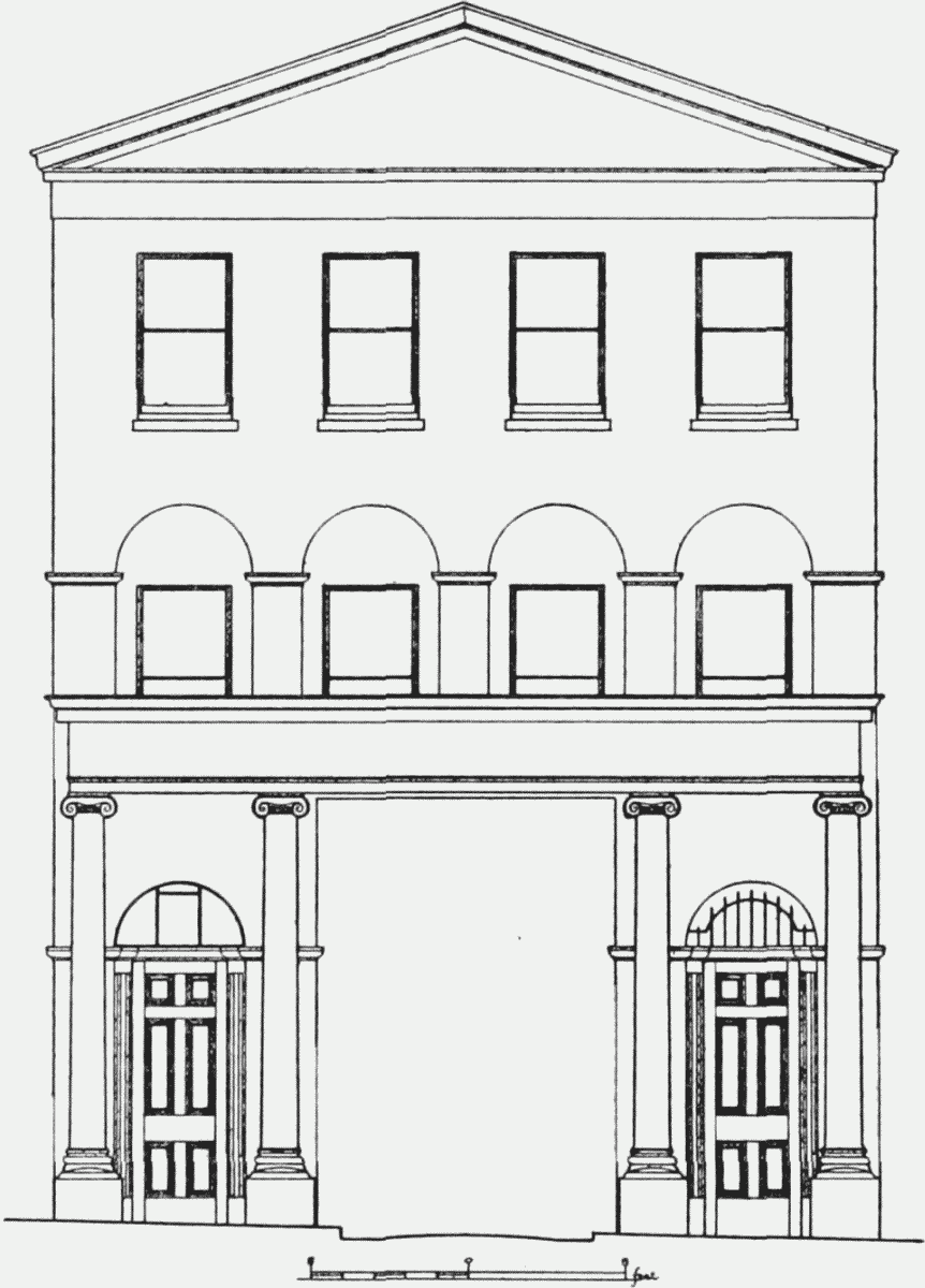
Some reference should be made to an ambitious scheme projected (fn. 17) by Signor Gesualdo (Gemaldo) Lanza (1779–1859), an Italian teacher of music, to provide a centre for music and the drama on an island site facing Euston Road and contained within Birkenhead Street and Argyle Street. Lanza had a deserved reputation as a singing master, and with the help of the architect, Stephen Geary, a plan was produced, a copy of which is in the Crace Collection at the British Museum. In the centre of the site was a large building styled the Grand Panharmonium Theatre, facing north, with a refreshment room to the east and a ballroom to the west, stretching together across the whole site. The space south of the theatre was to be occupied by pleasure gardens, with a music gallery built against the theatre itself. In front of the theatre was a courtyard with two approaches from Euston Road on the site of the present Crestfield and Belgrove Streets. Residences were to be built on the Euston Road frontage and in other parts of the site. A dramatic school was also to be built facing Birkenhead Street. There were to be picture galleries, reading rooms and many other features as well.
As far as can be gathered the only building actually erected was the little theatre in Birkenhead Street (see p. 110) which may have been that first intended as a dramatic school. But there seems to have been some preparation of the grounds which were furnished with an overhead railway from which cars were suspended (fn. 101) (see illustration on p. 104).
The opening day was on Thursday, 4th March, 1830, but the project was short lived. On 28th February, 1832, particulars of sale were published concerning bricks, balustrades, gates, plaster figures and unfinished buildings, "late the Panarmonion Gardens." The ground was to be carved into plots and laid into "a new square called Argyle Square." Demolition must have followed immediately, for a newspaper cutting of 20th March, 1832, refers to an accident when an arch was being pulled down "at the Piano Gardens near Battle Bridge." A plan drawn by Ebenezer Perry in 1832 for a re-distribution of the property shows the lay-out of the streets that exist to-day.
Battle Bridge Field, east of Gray's Inn Road, occupied the area south and west of the Fleet Brook and north of the Swinton Estate. These boundaries are clear from the numerous entries in the Middlesex Land Registry as the land was divided into building plots. In Rocque's map of ten miles round London, published in 1746, he shows a group of about nine houses at Battle Bridge at the junction of Gray's Inn and King's Cross Roads, but these were north of the river. In 1767 the field south of this belonged to John Smart of Poplar and Mary his wife. Its rapid building development dates from this year when they let (fn. 102) part of it to Richard Hedges, carpenter, of St. Pancras. Britannia Street was the principal road leading eastwards from Gray's Inn Road; parallel to it were George Street (south) and Charlotte Street, Field Street and St. Chad's Place (north). Connecting these was Paradise Street, running north to south behind the houses in Gray's Inn Road, called Chad's Row or part of Constitution Row. The development was continued by John Smart's only son and heir, Richard Smart, described as of Mile End Old Town, Stepney, gentleman. Among the builders who took up leases were James Usher, carpenter, of Laystall Street, St. Andrew's Holborn (1773), John Seager of Battle Bridge, builder (1778) and Thomas Fish of Salisbury Street, St. Martin-in-the-Fields, bricklayer (1783). (fn. 103) The whole of this estate has been entirely demolished and rebuilt.
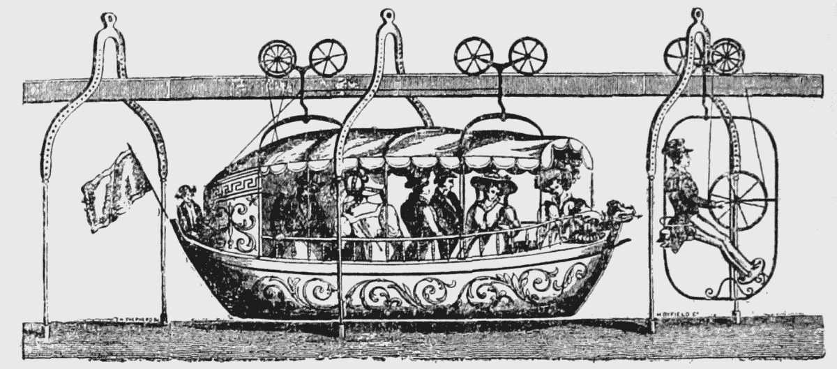
SUSPENSION RAIL–WAY, ROYAL PANARMONION GARDENS, LIVERPOOL STREET, KINGS CROSS, NEW ROAD, Sr. PANCRAS
WILLIAM THE FOURTH, ROYAL CAR.
CXXIX—Argyle Square
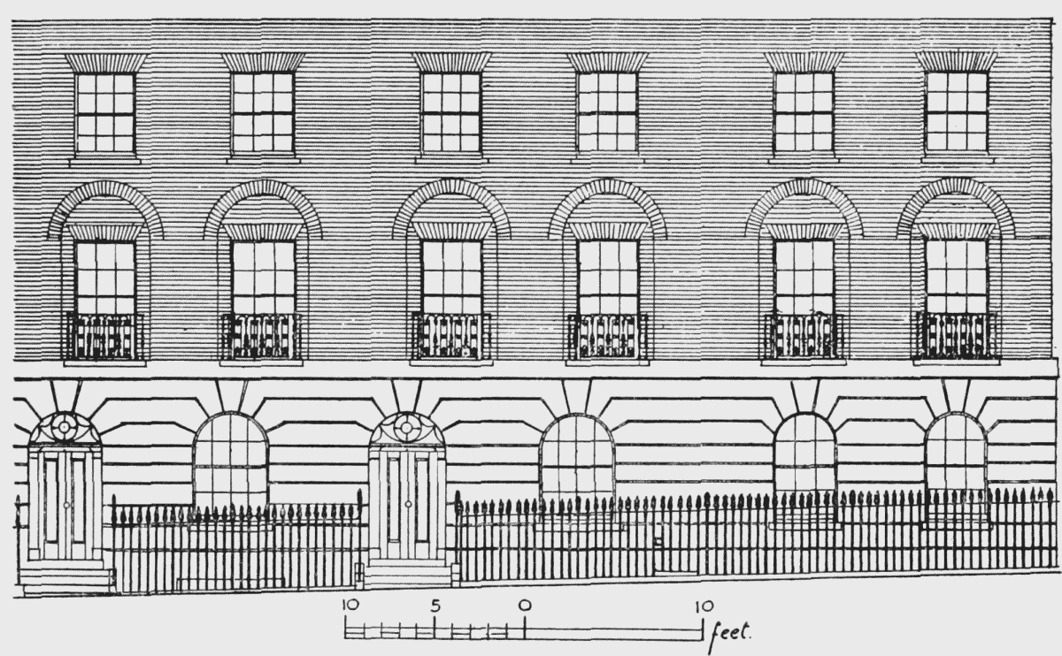
Argyle Square is situated between St. Chad's Street (formerly Derby Street), which divides the western part of the estate into northern and southern parts, and Argyle Street (formerly Manchester Street) which bounds the estate on the south. In 1840 the first two houses appear in the rate books, entered in pencil, indicating no doubt that they were not yet occupied. Nos. 1 to 13 and 33 to 40 were completed by 1844, and a further three houses appeared in 1849 when the square was fully built.
Nos. 40 and 41 Argyle Square
It is interesting to find that the "town-planning" of an area of even "third-class" houses included a square, and it certainly must have been attractive with its modest houses adorned with convex fronted balconies and lotus flowered railings. The north side, comprising Nos. 1 to 6, has been re-developed. The remaining sides are numbered clockwise 7 to 25 on the east, 26 to 35 on the south and 36 to 47 on the west. The houses, now mostly hotels and boarding houses, are all of one type with stucco-fronted basements and areas, ground storeys with architraves to the roundheaded doors and windows, and three upper storeys of brick. There are the usual balconies to the first floor. Straight joints in the brickwork indicate that the houses were erected generally in groups of four. No 25 at the corner of Argyle Street was badly damaged and has been restored. Nos. 7 and 47 at the corners of St. Chad's Street and No. 36 at the corner of Argyle Street have their entrances at the sides.
On the south side of the square, between No. 26 Argyle Square and No. 68 Argyle Street stood the Swedenborgian New Jerusalem Church. It was designed by J. D. Hopkins in the Anglo-Norman style, and was opened on 11th August, 1844, a year after the foundation stone was laid. (fn. 104) The church has been demolished and its site incorporated into the area covered by flats.
CXXX—Argyle Street
Argyle Street runs southward from Euston Road at a point opposite St. Pancras Station and then turns sharply east to Gray's Inn Road, forming the southern boundary of the Battle Bridge Estate. The owners of the land, Messrs. Dunston, Robinson and Flanders, decided to develop it in 1832, and a plan of the houses proposed to be erected was prepared by their surveyor Ebenezer Perry. (fn. 99) The four parallel streets (Argyle Street, Belgrove Street, Crestfield Street and Birkenhead Street) were set at right angles to the New (Euston) Road leaving a triangular strip of land next the Skinners' Estate and situated behind the present theatre. This was utilized for a brick cow-shed and dairy offices over 300 feet long, let in 1832 to Lewis Raphael, dairyman, of Golders Green. (fn. 105)
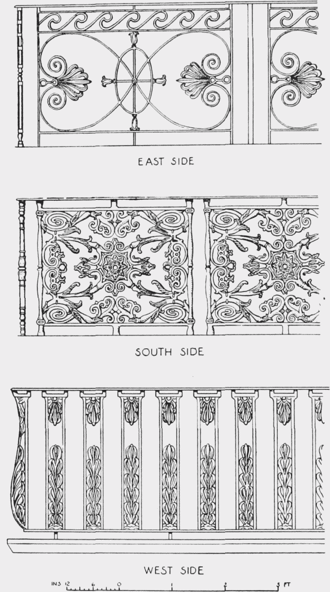
Type of Balconies in Argyle Square
The Building of the original Argyle Street was begun in 1833, when the poor rate books of St. Pancras show the first eleven houses on the western side southwards from Euston Road. The same number opposite on the east side were next built and finished in 1839. By 1849 the street of fortyone houses had been completed and was numbered consecutively from No. 1 at the north-west corner to No. 41 at the north-east corner. It has since been re-numbered (see below).
Manchester Street, the former name of the eastern section of Argyle Street, does not figure in the rate books till 1826, when five houses at the Gray's Inn Road end appear, followed by three others in 1827. There were sixteen houses in 1830. In 1832 a building lease (fn. 106) was granted to Robert Eckett of Hadlow Street, Burton Crescent, to build the first four houses (exclusive of the corner house) on the southern side of the Gray's Inn Road end. Britton's map of 1834 shows that at least a further ten houses had then been added on this side. Thereafter building seems to have progressed slowly until 1849, when there were forty-seven houses, which comprised the full complement of the street.
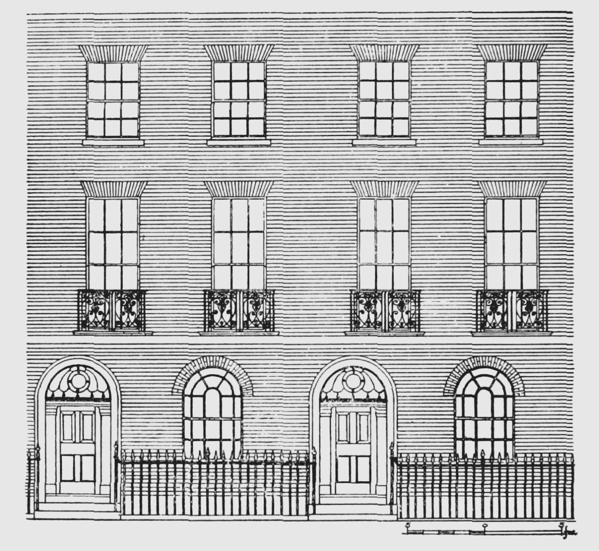
The houses of Argyle Street differ from those in the square of the same name chiefly by the absence of moulded stucco architraves around the windows, which on the first floor are recessed within brick arches in the external face of the wall. This feature they share with houses at the northwestern extremity of Gray's Inn Road. The smaller houses of Argyle Street have only two storeys, but the larger ones have an attic floor contained within a mansard roof. The present numbering of the street commences at the north end with odd numbers on the east and even numbers on the west side. Between Euston Road and St. Chad's Street, Nos. 7 to 19 and, south of the latter, Nos. 27 to 47 remain, and are of one design. They are of brick having the usual basements with railed areas, ground storeys with round-headed windows and doorways, and two upper storeys; the first floor windows are square-headed, set in shallow round-arched recesses, and have individual balconies.
Nos. 4 to 36 are similar but the doorways have archivolts and some of the ground storeys are wholly stucco-fronted. No. 36 has been repaired in yellow brick; the houses south of this, Nos. 38 to 44, to Whidborne Street have been demolished. Most of these buildings are now hotels and boarding-houses. No. 46, south of Whidborne Street in the angle, is a plainer brick house retaining the sign of the Duke of Wellington.
At the bend, on the north side, are three later projecting shops below a wall of modern brick, probably a post-war repair or alteration; a doorway at the side of the corner shop is old and round-arched like the others and may have belonged to the original No. 45.
The south side of the former Manchester Street continues the even numbers. Nos. 48 to 54 are of brick with basements. The ground storeys have round-arched windows and doorways, the latter with archivolts of stucco. There are two upper storeys and mansard attics. The tall first floor windows have no balconies. Nos. 56 and 58 are similar but have no stucco work or attics. There are straight joints in the brickwork on either side of this pair.
Nos. 60 to 66 have basements and ground storeys with stucco architraves to the round-headed doorways and windows, and three upper storeys with stucco architraves to the first floor windows. Not only are these houses higher but the storeys themselves are taller than those of No. 58, etc., to the west. The next house adjoining on the east is No. 35 Argyle Square.
East of the south range of the square stand the flats erected by the St. Pancras Borough Council on both sides of the street, but at the east end three old houses are still standing. Nos. 106 and 108 are still occupied; they have basements, round-headed doorways and windows to the ground floor, and two upper storeys with first floor balconies. No. 110 (next to the derelict No. 249 Gray's Inn Road) has a shop front with two brick upper storeys.
CXXXI—Belgrove Street (formerly Belgrave Street)
Belgrove Street leads from Euston Road to St. Chad's Street. The rate books indicate that building was begun at the Euston Road end in 1834, when the first four houses are entered in pencil as shortly due for rating. By 1839 there were seventeen houses. Daw's map of 1868 (on which it is still spelled "Belgrave Street") indicates that this was its full complement, much of its length being absorbed by the back and front gardens of Hamilton Place (as the large houses facing the Euston Road were then called).
Nos. 7 and 8 Belgrove Street
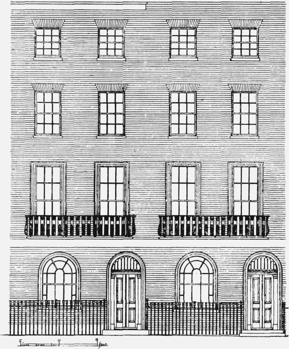
Although the houses are narrow, rarely exceeding 16 feet wide, and can have been intended only for tenants of moderate means, they exhibit considerable ingenuity in design. All the detail is admirably executed and they have a marked dignity of composition. The round-headed doors and windows of the ground floor are spaced independently of the rectangular windows above. The ground floor windows have radiating bars in their upper sashes, which for the most part are square-framed for simplicity of construction and to prevent warping; they slide into square-headed recesses in the walls so that they give the appearance of round-arched windows until lowered for airing the rooms. The doors are four-panelled in place of the earlier six-panel types and are hung to posts in the form of pilasters, with fanlights above.
Of the original houses only Nos. 1 to 8 on the west side remain.
CXXXII—Crestfield Street (formerly Chesterfield Street)
Crestfield Street leads from Euston Road to St. Chad's Street and is parallel with Belgrove Street. In 1825 Messrs. Dunston, Robinson and Flanders granted (fn. 107) to W. Forrester Bray of Liverpool Street, St. Pancras, builder and auctioneer, the two end plots on the east side adjoining Euston Road.
Nos. 1, 2 and 3 Crestfield Street
Mr. Bray's houses are the only ones appearing in the rate books till 1840, when there are pencil entries of four others shortly ready for occupation; the street is shown fully built in 1841.
The houses are similar to those in Argyle and Birkenhead Streets, except that they are to a greater extent faced with stucco on their ground floors. The patterns of windows, doors and fanlights follow those to be seen in the neighbouring streets. The illustration of Nos. 1 to 3 on this page shows their character.
CXXXIII—Birkenhead Street (formerly Liverpool Street)
Birkenhead Street leads from Euston Road to Argyle Street. In 1825 the rate books give its first two houses as newly built at the Euston Road end, adjoining Hamilton Place. In 1827 five more were added. In 1833 there were thirty-three; by 1849 the full complement of sixty houses was reached. Some of them were built by W. Forrester Bray, who appears to have had limited capital and to have acquired sites on mortgage from the landowners, Messrs. Dunston, Robinson and Flanders. It seems likely from the similarity of the designs that he built much of Crestfield, Belgrove and Argyle Streets.
On the western side of the street near its northern end was the Royal Theatre, and south of it, with one house intervening, is a Wesleyan Chapel. They are shown on Perry's plan of the street in 1832 (fn. 99) and both appear in a water-colour in the Council's Collection (Plate 78b). The theatre had a front rendered in stucco with pilasters and niches above. It has been altered somewhat in its design and is now converted into a restaurant. The Royal Theatre, called the Royal Clarence Theatre during the reign of William IV, was built as part of the Panharmonium project (see p. 103) and was first used by Signor Gesualdo Lanza for his pupils. It was opened as a public theatre by John Baldwin Buckstone and Mrs. Fitzwilliam in May, 1832. In 1838 it was known as the New Lyceum and subsequently as the Regent, the Argyll and the Cabinet. John L. Toole acted here and also Edmund Kean. It was still in existence in 1867, in which year G. M. Polini, the father of Marie Polini (who married Owen Nares) made his debut there. (fn. 108)
The view shows the chapel, with a brick façade, a central projecting porch, upper round-headed windows and a pediment over the whole front in stucco. At the end of the street a tree-planted area still existed on the site of the present taxi exit at the south end of King's Cross Station; beyond the Euston Road can be seen the gardens of the former Smallpox Hospital. Another drawing in the Council's Collection (shown on Plate 78a) gives an interesting view of the interior of the theatre.
The houses in Birkenhead Street are similar to those in Argyle Street. Nos. 1 to 7 on the east side and Nos. 54 to 59 opposite are all that remains of the original lay-out.
CXXXIV—St. Chad's Street (formerly Derby Street)
St. Chad's Street, runs from Gray's Inn Road across the head of Argyle Square to Argyle Street. It is residential only at its east end, the remainder merely connecting the transverse streets. According to the rate books the first house was completed in 1827; five more were built in 1828, and in the following year there were fourteen in all.
On the north side are now nine houses (Nos. 1 to 9) with basements and areas. The ground floor windows and doors are round-headed and there are two upper storeys. On the first floor the windows are rectangular within arched recesses and are mostly furnished with balconies. Nos. 1 to 4 have stucco architraves to the arched windows and doorways. Nos. 8 and 9 have had their upper storeys rebuilt but are derelict.
On the south side, next the building at the corner of Gray's Inn Road, are two houses (Nos. 13 and 14) of similar design except that the first floor windows have stucco architraves and hoods. West of these is an entrance to Whitbread's Bottling Depôt; this is contained within Birkenhead Street and Gray's Inn Road, St. Chad's Street and Argyle Street, and on Britton's map of 1834 is represented as a long courtyard building marked "Institution" and on the 1871 ordnance as "The London General Depository." The main entrance is from Gray's Inn Road (see further description below).
CXXXV—Gray's Inn Road West Side (Nos. 251 to 345), East Side (Nos. 326 to 378)
The range of twenty-nine buildings (Nos. 251 to 307) between Argyle Street and St. Chad's Street, with the exception of the entrance to Whitbread's (No. 277, see below), possess shops with two storeys of plain brick facing above. The first floor windows are set in arched recesses as elsewhere on this estate. The twelve houses north of St. Chad's Street (Nos. 311 to 333) are similar. Nos. 335 to 337 form a post office. Nos. 339 and 341, which are older, have plastered upper storeys. A number of the shopfronts are original and have swept ends to their fasçias.
No. 277 Gray's Inn Road
The building, now occupied by Whitbread's, which lies behind Gray's Inn Road, was originally designed for use as the North London Horse Depository. The engraving (Plate 80), shows a large courtyard, treated in stucco with some architectural pretension. Its principal entrance still exists under No. 277 Gray's Inn Road, which has a stucco front with an Ionic portico of four columns framing the central carriage way and flanked by its two arched doorways. The two storeys above have plain sash windows and the whole is finished with a pediment. The other entrance is on the north, from St. Chad's Street. In September, 1832, Robert Owen, who, eight years before had started a London Co-operative Society with rooms in Burton Street, took over the building from its owner, a man named Bromley, to form an "Equitable Labour Exchange," the purpose being "to promote the exchange of all commodities by giving equal values of labour," the currency used being specially designed "labour notes." The Bazaar, as it was called, attracted a great number of customers, but owing to Bromley's exorbitant claims for rent, Owen moved his Exchange in the next year to Charlotte Street, Fitzroy Square. (fn. 7) When in April, 1832, Edward Irving was expelled from his church in Regent Square, the larger part of the congregation, numbering some 800, met in the Assembly Room here, but not relishing the association with Robert Owen, they moved in the autumn to Benjamin West's picture gallery in Newman Street. (fn. 72) After Owen's departure Bromley attempted to carry on business as the Royal London Bazaar, and an additional attraction was advertised when in December, 1833, Madame Tussaud's Waxwork Exhibition came here from Brighton. The waxworks removed to Baker Street in March, 1835, and to Marylebone Road in 1884. (fn. 109)
On the opposite side of the street there is little left for notice. No. 328, to the north of Swinton Street, preserves the name of its celebrated predecessor in this neighbourhood, The Pindar of Wakefield. A little further north (between Nos. 330 and 334) stood the Church of St. Jude. It was the first church to be built in London by the aid of the Bishop of London's Fund, initiated by Archbishop Tait when he was Bishop of London. (fn. 4) It was designed by Joseph Peacock and was consecrated in 1863. It was built in the style of the 13th century with red and yellow bricks and had an aisled nave and chancel. The church was demolished in 1936 when the parish was united with that of Holy Cross, Cromer Street, to which many of its memorials and fittings were removed (see p. 95).
Incumbents:
| 1863 | John Marshall Andrews (d. 1896) |
| 1888 | William Dalrymple Fanshawe |
| 1898 | Frederick Henry Bolingbroke |
| 1909 | Alfred Newns |
| 1920 | Rowland Mark Pitt |
| 1926–1935 | George Wallace Johnston |
The entrance to St. Chad's Well was at one time situated between Nos. 364 and 366. William Hone in his Everyday Book, published in 1841, describes the faded inscription ST. CHAD'S WELL, which "stands or rather dejects over an elderly pair of wooden gates" there, and the "low old-fashioned, comfortable-looking, large-windowed dwelling" near the well. The dwelling-house is the subject of a drawing in the Heal Collection reproduced on Plate 79a. The waters here had some of the popularity of those at Bagnigge Wells, but by the time Hone visited St. Chad's it had ceased to be frequented, except by a few "locals" and "old cronies."
CXXXVI—King's Cross Road West Side (Nos. 127 to 215)
The houses on the west side of King's Cross Road were mostly built in the middle of the 19th century. Nos. 127 to 137 and 143 to 147 are of this period, the latter with shops and two storeys of plain brick above. Nos. 149 to 161 and 165 to 171 are later and taller buildings. Similar houses are Nos. 173 to 179, and Nos. 187 to 205. Many buildings have suffered war damage and only the shop of No. 215 survives.
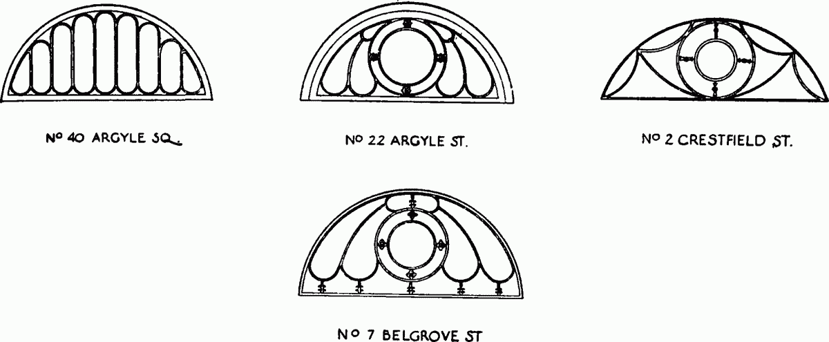
Fanlights at Nos. 40, Argyle, Square, 22, Argyle Street, 2, Crestfield Street, and 7, Belgroove Street, Drawings by A. R. Hansen (London County Council)