A History of the County of Northampton: Volume 3. Originally published by Victoria County History, London, 1930.
This free content was digitised by double rekeying. All rights reserved.
'The borough of Northampton: Description', in A History of the County of Northampton: Volume 3, (London, 1930) pp. 30-40. British History Online https://www.british-history.ac.uk/vch/northants/vol3/pp30-40 [accessed 11 April 2024]
DESCRIPTION
The parts of the town that have been longest inhabited are round the castle site and the churches of St. Peter and the Holy Sepulchre. The convergence of streets on the Mayorhold, (fn. 1) together with the name Newland and the reference to the waste open space by All Saints' Church in 1235 suggest that the oldest town lay entirely to the west of the road from London to Leicester. Dr. Cox believed that the wall built by Simon de Senlis I (1090–1111) ran south of St. Andrew's Priory and west of St. Giles' Church, and that the tower which was still standing not far from the Derngate in Lee's time was a survival from the Norman wall, whilst the line of wall shown on Speed's map in 1610 is assigned by him to about 1301. (fn. 2) Grants of murage were made to the town in 1224, (fn. 3) 1251, (fn. 4) and 1301, (fn. 5) the last on so large a scale as to suggest rebuilding rather than repairing. On the other hand, the action of the prior of St. Andrew's in 1264 (fn. 6) seems to prove that the priory was then inside the town wall. Further repairs of the wall were authorised in 1378, (fn. 7) 1400, (fn. 8) and 1549. (fn. 9) The wall ran north and east of the town; to the west and south the river and the castle fortifications formed adequate defences. The line of the later wall and ditch is still clearly traceable from its north-west corner on the river, along the south side of St. George's Street (North Gate), Campbell Street, the Upper and Lower Mounts (East Gate), York Road, Cheyne Walk (Dern Gate), Cattle Market Road (South Gate), Weston Street, across the gas works (Marvell's mill postern) (fn. 10) and so up to the West Gate near the castle, on Black Lion Hill. There was also a postern between the East Gate and the Dern Gate, near St. Giles' Churchyard, (fn. 11) and another called the Cow Gate, (fn. 12) leading from Cow Lane (now Swan Street) into Cow Meadow. The four main gates stood where the Market Harborough, Kettering, London and Daventry roads entered the town.
The gates, (fn. 13) and the East Gate in particular, (fn. 14) are mentioned in John's reign. Those mentioned by Lee in the 17th century appear from his description to have been built in the 14th century, the East Gate being very handsome and adorned with coats of arms; the other three main gates being then used as tenements for the poor. (fn. 15) Sir Thomas Tresham describes the guard kept at the South Gate, with partisans and halberds, on the morning of Lady Day 1603, when he came to the town with the news of Queen Elizabeth's death. (fn. 16) The wall, or a part of it, between the East and North Gates, is described in an inquisition ad quod damnum of 1278. It was then crenellated and much used for walking purposes, by sick burgesses when they wished to take the air, by all who wanted to take short cuts to avoid the muddy lane below in winter, and by the night watchmen who spied through the battlements upon malefactors as they came in and out of the town. (fn. 17) The sheriff notes that the opposition to blocking up the battlements and the wall-walk was so strong in the town that he chose the jury from outside the borough, from Billing, Boughton, Moulton, Weston and Overstone, but their verdict was as emphatic as the townsmen could wish, and nothing was done. The walls, which had been allowed to fall into a bad condition in the 16th century, were repaired by the strenuous labours of the townsmen in 1642–3; (fn. 18) and they were destroyed by royal order in 1662. (fn. 19) A drawing in the British Museum by a foreign artist shows them as they were in 1650, when there was, apparently, no wall between the East Gate and Marvell's Mill postern. (fn. 20) The town ditch, mentioned in the inquests of 1274–5 (fn. 21) and the town terrier of 1586, (fn. 22) survived the walls for a good while; part of it, near St. Andrew's Mills, was still visible in 1849, (fn. 23) whilst the section north of the Cow Meadow had only recently been filled in. (fn. 24)
If the earliest centre of the town was indeed, as the evidence indicates, the Mayorhold, it was probably the building of the castle (fn. 25) which caused the centre of gravity to shift eastwards. From the 13th century the modern market square is the commercial and civic heart of the town; and a series of deeds dealing with the transfer of house property, shops and stalls suggest the growth of a thriving eastern quarter. Early in the 14th century, however, complaints are heard of the 'decay' of the town. The petition of 1334 speaks of houses fallen to the ground, and rents thus lost; (fn. 26) an ordinance of about 1390–1400 provides for the letting out by the mayor and chamberlains of certain waste places from which no returns or profits have accrued for some time past. (fn. 27) In 1484 Richard III, in remitting fifty marks of the fee farm, accepts the mayor's account of the town as in great desolation and ruin, half of it almost desolate and destroyed. (fn. 28) Conditions were presumably made worse by the fire of 1516, which, according to Henry Lee, consumed the greatest part of the town. (fn. 29) In 1533, Leland noted that all the old houses in Northampton were built of stone, but the new houses of wood. In 1535 an Act of Parliament empowered the mayor and burgesses, in view of the great ruin and decay of the town, to take into their hands any houses which the tenants and landlords both failed to repair, and rebuild them themselves. If the mayor and burgesses failed to do so, anyone who pleased might rebuild the houses and so acquire possession of them and the land on which they stood. (fn. 30) Again, in 1622, the mayor, in sending up to the Privy Council the corporation's contribution to the fund in aid of the palatinate, explained that the decay of the town prevented the general contribution from being good. (fn. 31) Some of these complaints may be common form; but the maps of Northampton before the fire of 1675 show large vacant spaces within the walls, especially in the S.E. quarter of the town. (fn. 32) There seems no reason to doubt that houses fell into ruin and were not rebuilt, and that the open spaces shown in Noble and Butlin's map of 1746 represent some of the 'ruin and desolation' described in 1484. The terrier of 1586 describes a large number of closes and orchards within the walls, and Northampton was long after that date noted for its cherries.
The returns of 1274–5 suggest that one cause of this 'decay' may have been the exodus of burghers who settled outside the borough boundaries to escape the burden of tallages and the like. From an early date there are references to houses in the suburbs, outside the walls, (fn. 33) though the Portsoken of the 1189 charter is probably a clerical error. To the north and east, where the town fields extended to the parishes of Kingsthorpe, Abington and Weston, there were houses outside the North Gate along the Market Harborough road round the churches of St. Bartholomew and St. Lawrence; (fn. 34) whilst outside the east gate St. Edmund's End grew up round St. Edmund's church, (fn. 35) and Gobion's homestead is described as lying in the suburb in John's reign, (fn. 36) though it rendered an annual rent to the preposituram ville. (fn. 37) South of the town, between the walls and the river, grew up the south quarter, still containing many waste places in 1430 which the mayor and chamberlain leased to sixteen different tenants in that year. (fn. 38) Here later was the important house of the Fermors or Farmers. Besides these suburbs, within the liberties but outside the wall, there were from a very early date important suburbs outside the liberties. Round the abbey of St. James, (fn. 39) founded about 1100 on the west side of the river, grew up St. James' End, in the parishes of Duston and Dallington. The earliest reference to the name that has been traced is in 1358, (fn. 40) but a 13th century cartulary of the abbey which mentions various streets by name shows that it was then of considerable extent. (fn. 41) South of the river, in Hardingstone parish, Cotton End (fn. 42) or St. Leonard's End, grew up along the London road round St. Leonard's Hospital and chapel. (fn. 43) In 1618, by the charter of James I to the town, St. James' End, Cotton End and West Cotton were included within the liberties, but this extension seems only to have lasted a few years, and these suburbs passed back to the county until 1901. (fn. 44)
On 20 September, 1675, a fire broke out in St. Mary's Street, near the castle, which, driven by a strong west wind across to St. Giles' Street and Derngate, destroyed more than half the town in 24 hours. Corn ricks and maltings in the Horsemarket, thatched roofs and wooden houses everywhere, oil and tallow in College Lane and timber stacked in the market place for building the new County Sessions House, all fed the blaze. The 15th century market cross, the great part of All Saints' Church with the town records stored in it, and some 600 houses were destroyed. The town hall escaped, though the staircase in front of it was burnt, but most of the buildings round the market square perished. Only one house in the Drapery survived, and Dr. Danvers' house on Market Hill, which, like the Hesilrige Mansion in Marefair, now the Ladies' Club, is still standing. (fn. 45) The tradesmen of the town had just restocked their shops at Stourbridge Fair, and the general loss of property was estimated at £150,000. In this emergency both town and county acted with promptitude. The town Recorder, the Earl of Northampton, sent in supplies at once; a meeting at the town hall 'principally managed by him,' led to the opening of a subscription list and the setting up of a committee; and by his help an Act was got through Parliament before the close of the session for the rebuilding of the town. By this Act (fn. 46) a special court of record was constituted to sit at the guildhall and determine all disputes between neighbours, landlords, tenants and occupiers as to boundaries and titles, with power to alter the lay-out of the town if it should seem necessary, and to prescribe rules for rebuilding and enforce obedience to them. The records of this court are preserved at Northampton and form a substantial volume. They extend from April 1676 to October 1685, and deal with 79 cases. (fn. 47) Briefs and pamphlets (fn. 48) brought in generous contributions from all over England, from individuals, beginning with the King, from towns and from the two universities, amounting in all to £25,000, and the subscription list drawn up by Henry Lee the town clerk is still to be seen in All Saints' Church. (fn. 49) No great alterations were made in the town plan; the definite recommendations of the Act for widening the approaches to the market square, the narrowness of which had much increased the loss of property, were for the most part not followed, though All Saints' Church was shortened by the length of its nave and more space was thus secured in the south-west corner. Eighteenth century taste entirely approved the style of the rebuilding: Northampton, 'nobly re-edified after the fire, is now universally owned to be one of the neatest towns in the kingdom,' (fn. 50) but it was admitted that the town arose 'though much more beautiful, less spacious.' (fn. 51) The great increase in the size of the town began in the second half of the 18th century. The population rose from 5,136 in 1746 (fn. 52) to 7,020 in 1801, 15,351 in 1831, 32,813 in 1861, 87,021 in 1901 and 90,923 in 1921. The increase between 1801 and 1831, which is well above the average increase over all England, is attributable to the stimulus given to the boot trade by the Napoleonic wars. The number of houses increased from 2,086 in 1821 to 3,239 in 1831. (fn. 53) The main growth of the town in the 19th and 20th centuries has been to the north-east, in the direction of Kingsthorpe, Kingsley and Abington. There has also been a considerable extension to the west and south, and a recent survey of the town (fn. 54) with a view to its future development advocates the formation of a garden city suburb on the rising ground south of the river, round the site of Delapré Abbey. The second Reform Act added parts of Dallington, Duston, Hardingstone and Kingsthorpe to the Parliamentary borough, but the municipal boundaries remained unchanged till 1901, when they were extended so as to include half Kingsthorpe, the whole of St. James' End and Far Cotton, with the exception of some small agricultural areas, and a large part of Abington, the area of the borough being thus enlarged from 1311 to 3,392 acres. (fn. 55)

Plan of Northampton Castle (Reproduced by permission of the executors of the late Rev. R. M. Serjeantson)
In the early middle ages the borough was, like Leicester, divided into four quarters, named after the four points of the compass. These are mentioned in the rolls of the eyre of 1253. (fn. 56) To these a fifth, the Chequer Ward, round the market place, was added, Dr. Cox thought about 1300. (fn. 57) These five wards, supplemented for a few years by those of St. James and Cotton End (fn. 58) in 1618, lasted down to 1835. Under the Municipal Corporations Act of that year the town was divided into three wards; the South Ward, south of Gold Street, St. Giles' Street and Billing Road; the East Ward, east of the Drapery, Sheep Street and the Kingsthorpe Road, and the West Ward, west of the same line. (fn. 59) Each ward was represented by six councillors on the borough council. With the increase in the population, the East and West Wards outstripped the South Ward, originally the most populous, and in 1897 the East Ward contained 6,898 voters, the West 2,325, and the South 1,380. In 1898, by an order of the Local Government Board, the town was divided into six nearly equal wards: the Castle Ward, the North Ward, St. Crispin's, St. Edmund's, St. Michael's and the South Ward. Further, after a two days' inquiry at Northampton Town Hall at the beginning of 1900, the Local Government Board approved a scheme for the enlargement of the municipal borough which was embodied in an Act passed on 30 July, 1900. (fn. 60) This Act (fn. 61) added to the six wards formed in 1898 the three new wards of Far Cotton, Kingsthorpe and St. James, each, like the six old wards, returning three councillors and one alderman. In 1912, under the Northampton Corporation Act, (fn. 62) the borough was divided into twelve wards, of which Castle and St. James' Wards were unchanged from those of 1901. The name of Far Cotton Ward was changed to Delapré Ward. Part of St. Edmund's Ward was added to South Ward. Three new wards were added: Kingsley, carved partly out of the old Kingsthorpe and St. Edmund's Wards; Abington, out of the old St. Edmund's and St. Michael's Wards; St. Lawrence's, out of the old Kingsthorpe, North and St. Crispin's Wards. These twelve wards each return three councillors and one alderman. (fn. 63)
Corresponding changes took place in the civil parishes of the town in 1902 as a result of the enlargement of the borough. In 1909 the four civil parishes of All Saints, St. Giles, St. Peter and St. Sepulchre were consolidated and formed into the civil parish of Northampton. (fn. 64) In 1914 the civil parishes of Kingsthorpe, Duston St. James and the parts of Dallington and Abington within the municipal boundary were added to the civil parish of Northampton. (fn. 65)
The CASTLE OF NORTHAMPTON, like most royal castles, was outside the borough liberties. Originally built by earl Simon I, from the time that it became the king's (fn. 66) it served the purposes of royal residence and stronghold and county government office and prison. The jurors of 1274–5 said that it 'belonged to the county,' (fn. 67) and an inquest of 1329 found that its constableship was by old custom appurtenant to the county and jurisdiction of the sheriff. (fn. 68) The uses to which the castle was put are illustrated by the fact that this inquest was held in the castle hall which the sheriff had been commanded to be prepared for the sessions of the justices in eyre, who sat from November 1329 to May 1330, (fn. 69) the mayor having been ordered to oversee these preparations. (fn. 70) In the same eyre the mayor protested on behalf of the town against the burgesses being forced to plead outside the liberties, but was unable to obtain a special sessions for the borough like that of 1285. (fn. 71) The castle was still outside the jurisdiction of the borough in 1655. A Duston litigant in that year writes, 'I delivered writs to the undersheriff to arrest G. and the rest. . . . He said Northampton was a privileged place and he durst not serve them. They durst not come down to the castle at Easter sessions last, for they had been out of their liberty and had been arrested.' (fn. 72) When the castle was dismantled in 1662, Charles II directed that as much should remain as was necessary for the shelter of the justices of the Bench, (fn. 73) and Henry Lee could remember the judge of Nisi Prius sitting at the castle with his back against the west wall of the Chapel of St. George. (fn. 74) The county magistrates sat there for quarter sessions down to the Epiphany term, 1671, (fn. 75) after which they sat in the town, presumably in the temporary building erected for the use of the Judges on Assize. (fn. 76) From 1670 to 1675 the town and county authorities were wrangling as to whether the new sessions house should be built in the town or on the castle site. (fn. 77) After the fire, however, it was mutually agreed that the county sessions house should be built in the town 'as an encouragement to rebuilding,' (fn. 78) and the castle ruins ceased to have any connection with the government of the county.
The greater part of the site of the castle was levelled in 1880 for the erection of the London and NorthWestern Railway Company's station and goods shed, and the records of what formerly existed are so fragmentary that it is difficult to reconstruct the original form of the castle. It seems to have been of the 'motte' and bailey type, common to the more important castles of the time. (fn. 79) The 'motte,' upon which stood the keep, surrounded by a moat, was apparently on the north-east side of the bailey where a flat-topped conical mound called Castle Hill was still a playground for children in the middle of the 19th century. This mound, under which a skeleton was found in 1827, (fn. 80) was approximately bounded by Chalk Lane, Castle Street, Phœnix Street and Castle Hill. The bailey, which was fortified by a rampart and ditch, was roughly circular in shape and covered about 3½ acres. It is now traversed by St. Andrew's Road, and a little to the east of the point where this road would cross the southern part of the moat was the southern entrance to the bailey, and at the spot where it would cross the northern part of the moat was the northern or principal entrance. The jamb of the gateway here was discovered in 1883. Outside this entrance were some earthworks, which it is thought covered the approach to the gate; they may, however, have been thrown up for siege purposes. The position of the curtain wall of the bailey is known on the south and west sides, and photographs exist of the wall and of a bastion on the south side. On the west side of St. Andrew's Road remains of buildings have been from time to time discovered together with four wells, and remains of the moat still exist at the northeast of the bailey in the garden of St Peter's Rectory, off Fitzroy Street. (fn. 81) Building accounts of the 12th century refer to repairs to the tower or keep (turris) as well as to houses in the castle (castellum). (fn. 82) The survey of 1323, moreover, refers to 'an old tower called Fawkestour,' which seems to have been at that date outside the curtain wall. (fn. 83) It does not appear to have formed part of the later fortifications, being ignored in Speed's map, and in the military drawing of 1650, (fn. 84) but it is shown in the plan in the Gentleman's Magazine for 1800, (fn. 85) which is of value as giving a crosssection from north to south of the bailey and the triple rampart guarding the northern entrance. It was finally levelled between 1827 and 1832, the earth from it being used to fill in the moat. (fn. 86)
The first Norman buildings may well have been of wood, since it would take time for the earthworks to become settled. Excavations in 1863 revealed, amongst later remains, a Norman chamber with a groined roof and a central column, which may have belonged to the castle of the time of Henry II. (fn. 87) The accounts of Becket's interviews with the King in 1164 mention a castle gateway, through which the archbishop rode; a hall; an inner chamber; an upper chamber where the King received the bishops who tried to mediate between Becket and himself; and a chapel. (fn. 88) From the time of Henry II onwards there are constant references on the Pipe Rolls, Close Rolls and Liberate Rolls to constructions and repairs at Northampton Castle. (fn. 89) The masonry uncovered in 1863 belonged mainly to the 13th and 14th centuries, and the records indicate the greatest building activity under Henry III, with extensive repairs under Edward II and Edward III. There is specific reference to the King's great chamber in the castle in 1235, (fn. 90) the King's chapel in 1244, (fn. 91) the building of the Queen's chapel in 1247, (fn. 92) fitted with glass windows in 1248, (fn. 93) the King's wardrobe, the great hall and the chaplain's room in 1249, (fn. 94) the wall of the castle and the bailey next the river in 1251, (fn. 95) further alterations to the chapel in the tower, and stained glass windows in the hall in 1252 and 1253. (fn. 96) A survey of 1253 refers to repairs already carried out on the great wall, but says that it needs further repairs. (fn. 97) In 1318 the great hall, the lower chapel and two other larger chambers were destroyed by fire. The survey of the castle in 1323, which reports this, mentions the 'new tower,' six small towers in the circuit of the castle wall, two stables, a new gate, two old gates, an old barbican, the mantellum of the castle, the hall court, the castle court and the garden. The repairs said to be necessary are estimated at £1,097 6s. 8d. (fn. 98) It does not seem probable that they were ever carried out; but the great hall, as we have seen, was made fit for the holding of the eyre of 1329–30, and the castle continued to be used both for royal and shrieval purposes. During the parliament of 1380, however, the king stayed at Moulton, and not at the castle, (fn. 99) and St. Andrew's Priory was used for the sessions. (fn. 100) Repairs mentioned in 1347 (fn. 101) and 1387 (fn. 102) suggest that the castle was being used mainly as a county gaol and sheriff's office—a checker house and a checker board are named. When Leland saw the castle it still had a large gate, (fn. 103) but in 1593 Norden described it as ruinous. It was probably repaired for the use of the Parliamentary garrison, and the drawing of 1650 shows a wall round both the inner and the outer bailey, and four turrets in the wall of the inner bailey. Soon after the castle ceased, about 1671, to be used as gaol and sessions house, the site which had been originally sold by the crown in 1629 (fn. 104) was resold to Robert Hesilrige, who acquired the adjoining strips of land from the borough in 1680. (fn. 105) A survey of the property in 1743 shows that the outer bailey was then known as the old orchard, and the inner bailey as the young orchard, both being well planted with fruit trees; the moat was called the upper and nether roundabout; the northern rampart, called the Fort in 1680, was known as the Castle Ground, and the whole, including the Castle holme, came to 18 acres. No traces existed, apparently of the wall of the outer bailey. The castle ground was built over between 1863 and 1880; in 1859 a small railway station was built on part of the old orchard, and in 1876, for the purpose of building the present Castle Station and goods yard, the rest of the site was bought by the London and North-Western Railway Company, and the remains of the masonry, including a circular bastion on the south, and a solid fragment of the wall on the river side, Norman at the core, reinforced with Edwardian facing and buttresses, were destroyed. The course of the Nene was diverted, the greater part of the earthworks levelled, and a new road cut across the levelled castle site joining Black Lion Hill to St. Andrew's Road. A postern from the wall above the river was re-erected in the southern boundary wall of the goods station, and this is all that now remains of the castle buildings. (fn. 106)
Whilst prisoners were still kept at the castle in 1655, (fn. 107) as early as 1630 (fn. 108) a house of correction for the county had been set up in the town, under the control of the county justices. This was in or near the old Bell Inn, (fn. 109) across the road from the south-east corner of All Saints' Churchyard, and it served as a county gaol, supplementary to that in the castle. Here probably the Quakers were confined, between 1655 and 1664, (fn. 110) who issued various tracts from their prison, and died, several of them, of their hard usage. (fn. 111) It was formally conveyed to the use of the county in 1670, as a gaol and bridewell. (fn. 112) The buildings were destroyed by the fire of 1675, and on the same site, as it seems, the present County Hall was erected between 1676 and 1678 from the designs of Sir Roger Norwich, by H. G. Jones, who rebuilt All Saints' Church. (fn. 113) The County House of Correction was at the same time rebuilt behind the Sessions House, and a house built by Sir William Haselwood on a piece of land to the west was used as a gaol and bought by the county in 1691. (fn. 114) Then, and for many years later, the county gaol looked south across Angel Street to the open country with no houses intervening. In 1777, when Howard visited it, some new cells had been built, but there was still an underground dungeon like that in which the Quakers had suffered. (fn. 115) In 1792–4 a new gaol and bridewell were erected to the south of the County Hall, and the old gaol was made into the turnkey's house. The new gaol was built so as to conform with Howard's recommendations and held 120 prisoners. This in its turn was found inadequate by rising standards, and an addition to the gaol was built to the east and south of the old site in 1846 by J. Milne. (fn. 116) This latest gaol, built for 140 prisoners, served the county till 1889, when, all prisons having been vested in the Secretary of State by the Act of 1877, (fn. 117) it ceased to be used, and the former borough gaol became the only prison in the town. The old county gaol was sold to Mr. J. Watkins in 1880, who sold the portion now used as the museum and art gallery to the Town Council. The remainder of the property was bought by the Salvation Army in 1889 and purchased from them by the County Council in 1914. The Salvation Army remained in occupation as tenants till early in 1928. The building is now being reconstructed to serve as additional offices for the County Council and a record room and students' room for the Northamptonshire Record Society. (fn. 118)
Northampton: The County Hall
The prison of the vill of Northampton, as distinct from the prison in the castle, is mentioned in 1253 (fn. 119) when the keeper of the prison is named. From an incident narrated by the jurors of 1274–5 (fn. 120) it appears that the bailiffs kept the key of the prison, and that any person who had a thief to imprison could apply to them for it. There is no means of locating the town gaol till the 16th century; then it is mentioned as adjoining the town hall, in Abington Street, and from 1584 some of the rooms under the town hall were used as prisons for some 200 years. (fn. 121) In 1777, owing, it may be, to Howard's visit, complaint was made that the town gaols were close and unfit for the reception of prisoners, (fn. 122) and a levy upon the town was ordered for the necessary repairs. (fn. 123) About 1800 the use of these rooms was abandoned, and a gaol was built by the town on a site in Fish Lane given by the corporation, and subsequently altered in 1823 and 1840. (fn. 124) This gaol was superseded in 1845 by the new town gaol on the Mounts, built by Hull on the Pentonville model and capable of holding 80 prisoners. (fn. 125) The gaol in Fish Lane became a police station. The gaol on the Mounts, the only prison in Northampton after the closing of the county gaol in 1889, was also closed in 1922, and Bedford prison now serves Northampton for male prisoners and Birmingham for female.
The earliest mention of the Town Hall is found in 1285, when the justices in eyre held their session for the borough 'in the common hall' (in communi aula). (fn. 126) The Guildhall or 'Gihalda,' is mentioned in the charter of Richard II of 1385, (fn. 127) as the place where the mayor and bailiffs hold their pleas, and in 1387 (fn. 128) as the place where the court of husting sat. Henry Lee says that the old Town Hall was in a little close, adjoining the last house on the right hand in the lane going from the Mayorhold to the Scarlet well, and he had seen a circular mark of stonework on the west end of the adjoining houses. (fn. 129) The second Town Hall, which stood at the south-east of the Market Square, between Abington Street and Dickers Lane, was apparently of 14th century origin. (fn. 130) The third story may have been added in the 15th century: possibly when the assembly began to be held here after 1489. The basement was used for shops in the Tudor period, and in the 17th and 18th centuries for a town gaol. The assembly books and the accounts report various repairs to the Town Hall in the 17th and 18th centuries. (fn. 131) The building was of three stories with battlemented parapet, the hall being on the first floor, and the ground story originally open. Several pointed two-light windows on the first floor long survived, though latterly in a more or less mutilated state, but the upper windows were squareheaded. The door and the outside staircase were burnt in 1675, but the rest remained until 1864, when, on the building of the new Town Hall in St. Giles Street, the old hall and its site were sold by auction for £1,200, and the old hall destroyed. (fn. 132) Some oak wainscot from the council chamber and an Elizabethan table with bulbous legs are in the Abington Museum.
The east wing of the present Town Hall, designed by E. W. Godwin, was built in 1861–4; the west wing, added in 1889–92, was designed by A. W. Jeffrey and M. H. Holding, the restorers of Castle Ashby. The public library was housed here with the museum, until 1883; the borough records are now preserved here.
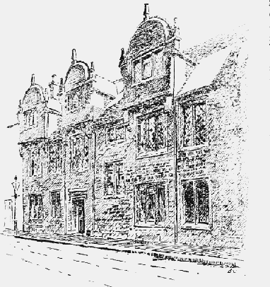
Of the few surviving houses which escaped the fire of 1675 the most notable is No. 33 Marefair, known as the Hazlerigg Mansion, since 1914 a ladies' club. (fn. 133) It is a stone-fronted building of two main stories, and attics with three rounded dormer gables corbelled out from the wall, and appears to date from the end of the 16th or early years of the 17th century. It was purchased by Robert Hesilrige in 1678, (fn. 134) and continued in the family till about 1835, (fn. 135) when it was bought by George Baker, (fn. 136) the historian of the county, who with his sister resided in it and died there. The building formerly extended farther to the east, with five gables to the street, and a frontage of about 97 ft., now reduced to 51 ft. 3 in. It has a squareheaded moulded doorway, and mullioned windows of two or three lights, all without transoms or hood moulds. There seems originally to have been a porch. (fn. 137) The interior has been much altered and the plan modified. None of the old fireplaces remains, but there is a good contemporary staircase with twisted balusters and moulded handrail. In one of the bedrooms are three large and two smaller pieces of tapestry. (fn. 138) The garden extended from St. Peter's Church to the present Freeschool Lane, and contained a summer house. The building was recently restored.
Northampton: The Town Hall
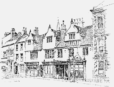
The so-called 'Welsh House' or 'Dr. Danvers' House' from Dr. Daniel Danvers who lived in it at the end of the 17th century (No. 2 Newland) at the north-east corner of the Market Place, (fn. 139) was until recently a building of some architectural interest, but the ground floor was first converted into shops and in 1924 the three lofty dormers of the attic story, with three-light windows and curved gables, were taken down. Little old work therefore remains except the walling and mullioned windows of the first floor, between which on the upper part of the wall are three shields with the arms of Wake of Courteenhall and Parker, and another shield which has been attributed to Danvers. (fn. 140) There is also a shaped device with tall finial, formerly surmounting one of the lower windows, on which are the initials and date 'W.E.P., 1595,' and the motto 'heb . dyw . heb . dym . dyw . a digon' (Without God, without everything, with God enough). Below the motto is a large shield with the arms of Parker with crescent for difference, flanked by two smaller unidentified shields. (fn. 141) The history of the building is not known, but judging from the initials and two of the shields, it may have been the residence of John Parker, serjeant at law, of Northampton, and built by one of the family. (fn. 142) It has a frontage facing west of 60 ft. and a depth of 37 ft., and is built of red sandstone, but the front was stuccoed and painted. Before the removal of the ground floor wall there was a pedimented doorway, two low mullioned windows, and a modern baywindow at one end. The roof was covered with stone slates, and there were three gables at the back corresponding with those in front, but plainer. The interior has been so altered that the original arrangements are lost.
Northampton: The Hazlerigg Mansion, now the Ladies' Club
A building on the east side of Sheep Street, the ground floor of which has been converted into six shops, (fn. 143) was originally the property of Lord Halifax and probably his town house, but it is best known as the residence of Dr. Doddridge and the seat of his Northampton Academy from 1740 to 1752. It is a long stone-fronted early 18th century building of three stories, the upper part of which remains unchanged, with sash windows and unbroken eaved roof. The middle story is divided by Ionic pilasters into a series of bays, as was also the ground floor, but the top story, which was added in Doddridge's time, (fn. 144) is quite plain. There was originally a wide central gateway, two arched recesses over which still remain.
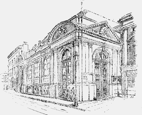
The County Hall, erected at the close of the 17th century in the Classic Renaissance style of the day, is a simple but dignified building of a single story, with high-pitched hipped roof, in which the entablature is supported by pilasters and coupled columns of the Composite order standing on a high base. The main front, facing north to George Row, is a well-balanced composition with a balustrade and curved pediment at each end containing the Royal Arms. The great hall has a richly ornamented plaster ceiling, completed in 1688. (fn. 145) The County Council Chamber, erected in 1890, and a Record Room built early in the 18th century stand behind the Hall.
The Judges' Lodging, a plain 18th century stonefronted house adjoining the County Hall on the east, was formerly a private residence, but was acquired for its present purpose in 1819.
The nucleus of the Public Library was the Northampton Mechanics' Institute, set up in 1832 in George Row. Though in 1849 it was described as 'more flourishing than most in the kingdom' (fn. 146) and possessed a library of 7,500 volumes, by 1876 it was in financial difficulties, and its books were handed over to form the beginnings of the Public Library. It was at first housed in the Town Hall; transferred in 1884, with the museum, to the old county gaol in Guildhall Road, which had been purchased by the town and reconstructed for the purpose; augmented in 1885 by the library of the Religious and Useful Knowledge Society (founded in 1839, consisting of some 5,000 volumes) and by a collection of Northamptonshire books, purchased by public subscription. A new wing was added in 1889. In 1901 the open access system was introduced; and in June 1910 the present buildings in Abington Street were opened. A juvenile library and reading room were added in 1912, and in 1921 a special local room, containing some 16,000 items dealing with the town and county, including books, pamphlets, prints, drawings, maps, plans, posters, playbills, photographs, manuscripts and transcripts. The Photographic Survey of the district is kept here. The library possesses a complete file of the Northampton Mercury, going back to May 1720. (fn. 147)
The Museum, in Guildhall Road, on the site of the county gaol, contains the remains from Northampton Castle, from Hunsbury, from Duston, from Towcester and Irchester, various Anglo-Saxon antiquities, and a collection of boots and shoes and other leather articles. There is also a small art gallery.
Another museum is at Abington Hall, which was presented to the town by Lady Wantage in 1894; most of the Natural History specimens are preserved here, and there are also local engravings and portraits of local worthies.
The first proposal for a county infirmary (fn. 148) was put forward by Dr. John Rushworth, son of a vicar of St. Sepulchre's, who practised as a surgeon in Northampton for many years. In a pamphlet addressed to the Surgeons' Company in 1731 he urged the desirability of Parliament's assisting in the erection of an infirmary in the centre of every county. He followed this up by an advertisement in the London Gazette, offering to give £50 towards the building of such an infirmary in his own county, and suggesting the calling of a meeting to discuss it, at Quarter Sessions or some other time. (fn. 149) Nothing, however, came of his suggestion till after his death. (fn. 150) In 1743 Dr. James Stonhouse, then aged 27, came to the town to practise, and within two months had circulated papers entitled 'Considerations offered to the Nobility, Gentry, Clergy and all who have any property in the County, with regard to the establishment of a County Hospital in Northampton.' The subject was brought up before the Grand Jury at the Assizes on 21 July, and the design being approved, a subscription was started on the spot. The project was warmly supported both by the county, the corporation, and the influential minister of Castle Hill Chapel, Dr. Doddridge, who preached a sermon on 4 September 1743, 'In favour of a design to erect a County Infirmary,' in which his detailed account of the eleven existing provincial and London infirmaries suggests that he must share with Rushworth and Stonhouse the honour of originating the scheme. A large edition of this sermon was printed. At a meeting of the subscribers on 20 September 1743, a committee was elected, and on 17 November 1743 the statutes and rules for the government of the hospital, modelled upon those of the Winchester Infirmary, were confirmed; and a house in George Row, to the west of the County Gaol, was obtained and fitted up by December. 'Thus has the project of a County Hospital at Northampton, of which some persons there wholly despaired, been brought to maturity in less than two months from the first meeting on this occasion.' (fn. 151) Three physicians, including Dr. Stonhouse, two surgeons and an apothecary, were appointed to the staff. All those who subscribed £2 a year or more were governors, the Grand Visitor was the Duke of Montagu, and the Perpetual President the Earl of Northampton. The formal opening took place on 27 March 1744. (fn. 152) The hospital contained thirty beds at its opening, and issued its first report in October 1744, when 103 in-patients and 79 out-patients had been treated. Up to 1829 the subscribers used to assemble on Anniversary Day to hear the annual report, and proceed to All Saints' Church to hear a special sermon and contribute to collections when the bag was taken round by the Countess of Northampton and other ladies of title. In 1753 the building was enlarged and the number of beds increased to 60, the financial strain being met by fresh appeals to the public, and in spite of setbacks the work of the hospital developed steadily and a further enlargement was made in 1782. In 1790 it was resolved to erect a new hospital, in view of the unfavourable report of Dr. Kerr, one of the governors, on the site, the offices and the water supply. (fn. 153) The new hospital was to accommodate 90–100 patients; and amongst other conditions it was laid down that each patient should be allowed 90 square feet, that no ward should contain more than 10 beds, and that the lavatories should be out of the wards. The new site was near St. Giles' Church, and had formerly been part of the possessions of St. Andrew's Priory. The new building was completed and opened for use in October 1793, patients from other counties besides Northamptonshire being admitted for treatment. In January 1804 the practice of free vaccination of out-patients was begun, and 1,882 persons were inoculated in the next five years. It is interesting to note that the building of the London and Birmingham railway, 1835–37, produced so many casualties that the Hospital Committee resolved 'that the managers of the railroad within reach of Northampton be informed that it is impossible that any more cases of simple fracture can be received into the House; compound fractures or such cases only as are attended with danger can be admitted.' The use of anæsthetics for surgical operations began in January 1847. In 1872, 1879 and 1889 further additions were made to the hospital, the last to commemorate Queen Victoria's jubilee; in 1896 a new operating theatre was added. The name of General Infirmary was changed in 1903 to 'The Northampton General Hospital.' In 1901 two new wings were erected, and the old building became a home for the staff, with a library and laboratories: the new buildings were opened on 2 June 1904, The constitution of the hospital was drastically revised in 1904 and a new board of management set up. The hospital has now 231 beds, with an average yearly number of 2,891 in-patients and 12,449 out-patients.
Northampton: Dr. Danvers' House before 1924
Other hospitals now existing in Northampton are: St. Andrew's Hospital (for Mental Diseases), the scheme for which originated at a meeting of the governors of the General Infirmary in 1814, but which owes its beginning to a gift from the second Earl Spencer in 1828. It was opened in 1836–7. The Northamptonshire poet, John Clare, died here in 1864. It will hold 500 patients, many of whose payments are assisted from the charity.
The Royal Victoria Dispensary, opened in 1845, served a useful purpose till the 20th century in providing medical service, on an assisted contributory basis. It was dissolved in February 1923, the building sold, and the assets handed over to the General Hospital.
The Northampton Queen Victoria Nursing Institution, opened in 1901, has two maternity homes dependent upon it, opened in 1918 and 1919, in Colwyn Road and Kingsthorpe Road. There are at the present time eight Infant Welfare Centres in the town, with an attendance of 700 mothers, and a staff of one lady doctor, and 4 health visitors assisted by 70 voluntary workers.
Of other important buildings, the Barracks in St. George's Square were built in 1796 on the petition of the townsmen; the Working Men's Club in St. Giles' Street was founded in 1865 by the late Major Whyte-Melville; the Opera House in Guildhall Road was erected in 1884, the Temperance Hall in Newland in 1887 and the Masonic Hall in Princess Street in 1889–90. A statue in terra-cotta of Charles Bradlaugh, for many years member of Parliament for the city, was unveiled by Sir Philip Manfield, M.P., on 25 June 1894 in Abington Square. There is also in the Market Square a monument with a bronze bust of Lieut.-Col. Edgar R. Mobbs, D.S.O., 'a great and gallant sportsman,' who raised a company of the Northamptonshire Regiment in 1914 and was killed in action 31 July 1917. The monument was unveiled by Lord Lilford on 17 July 1921. There is a bust of King Edward VII in the north-west angle of the wall in front of the General Hospital in the Billing Road.
A large proportion of the names associated with Northampton are those of divines of varying denominations. The famous schoolman, Duns Scotus, was ordained a priest in St. Andrew's Priory Church by Bishop Oliver Sutton on 17 March 1291. (fn. 154) Among the friars of the Northampton houses were the famous 13th-century Franciscan, Thomas Bungay, lecturer at both Oxford and Cambridge, who died and was buried here; the Dominican, Robert Holcot, the reputed author of Philobiblon and 26 other treatises, who died here in 1349; the Augustinian friar, Geoffrey Grandfelt (d. 1340); the Carmelites, John Avon, a distinguished mathematician, who died in 1349; William Beaufeu, a noted theologian (d. 1390), and Thomas Ashburne, the author (in 1384) of De Contemptu Mundi. Among the Anglican divines, besides a number of distinguished rectors of All Saints' and St. Peter's Churches, are T. Cartwright (1634–89), born at Northampton and educated at Chipsey's Grammar School, Bishop of Chester, 1685, and a wholehearted supporter of James II, like his fellow-townsmen, Samuel Parker (1640–88), Bishop of Oxford, 1686–88, and intruded by James II into the presidency of Magdalen College, Oxford. Among the famous Nonconformists, besides Doddridge and the Rylands, should be mentioned John Penry (1559–93), the reputed author of many of the Marprelate Tracts, whose wife was a native of Northampton, and who lived here 1587–1590; Robert Browne (fn. 155) (1550–1633), founder of the Brownists, who died in Northampton Gaol and was buried in St. Giles' Churchyard; and Samuel Blower (d. 1701), the founder of Castle Hill meeting house. Of literary worthies, Anne Bradstreet, the New England poetess (1612– 1672), should be noted as a native of Northampton; also Thomas Woolston, the freethinker (1660–1733), the son of a Northampton currier, deprived of his fellowship at Sidney Sussex College for his iconoclastic criticism of the Old Testament; Simon Wastell (d. 1632), headmaster of Chipsey's school and author of Microbiblion; and William Shipley (1714–1803), drawing master in Northampton, originator of the Royal Society of Arts; the two antiquaries, George Baker (1781–1851), author of an unfinished History of Northants, and his sister, Ann Baker (1786–1861), who helped to save St. Peter's Church from neglect and ruin, and compiled a glossary of Northamptonshire words and phrases; John Cole (1792–1848), bookseller and antiquary, the friend of Baker, the author of a short account of Northampton (1815), who published many antiquarian works, and made a collection of books on the town and county, now in the Public Library. E. A. Freeman, the historian, was a schoolboy in Northampton from 1829–37, and James Rice, collaborator with Sir Walter Besant in novel writing, was born here in 1843. Of the medical profession, besides Rushworth (1669–1736), Sir James Stonhouse (1716–98) should be mentioned, the founder, with Doddridge, of the County Infirmary, converted by Doddridge, and ordained as a deacon of the Church of England in 1749, practising medicine in Northampton 1743–64, and ending his life as a parish clergyman. Sir Charles Locock (1799–1875), accoucheur to Queen Victoria, was a native of Northampton. In connection with political life, Sir Richard Lane (1584–1650), deputy recorder of Northampton, a native of Courteenhall, defended Strafford on his trial, and was made Lord Keeper in 1645. Spencer Perceval and Bradlaugh have been mentioned in connection with the parliamentary history of the borough. R. G. Gammage (d. 1888), a native of Northampton, was an active organiser of Chartism in Northampton and the neighbourhood, and author of a History of the Chartist Movement (1854). W. L. Maberley (1798–1885), member for Northampton from 1820 to 1830, was secretary of the General Post Office and a diehard opponent of Rowland Hill's postal reforms from 1846 to 1854, 'wasting millions of public money.' (fn. 156)