A History of the County of Gloucester: Volume 8. Originally published by Victoria County History, London, 1968.
This free content was digitised by double rekeying. All rights reserved.
'Parishes: Corse', in A History of the County of Gloucester: Volume 8, (London, 1968) pp. 271-281. British History Online https://www.british-history.ac.uk/vch/glos/vol8/pp271-281 [accessed 24 April 2024]
In this section
CORSE
Corse is a rural parish of 2,220 a. (fn. 1) lying on the tongue of land between the rivers Severn and Leadon, 6 miles NNW. of Gloucester and 7 miles south-west of Tewkesbury. The parish boundaries, which for the most part do not follow natural or ancient features, (fn. 2) have long remained unchanged and are the same on the north and west as in the 11th century. (fn. 3)
Most of the parish is flat clay land, lying between 70 and 150 ft. on the Keuper Marl, but on the east are the bold profiles of the Rhaetic beds underlying the Lower Lias, where the land rises steeply to the flat top of Corse Wood Hill at 281 ft. On the top of the hill Jeremiah Hawkins built c. 1825 a huntingtower, (fn. 4) long since demolished. The name Corse signifies a marsh or bog; (fn. 5) the district was, moreover, heavily wooded, as it remained until comparatively late, so that it is likely that settlement in Corse was also late. That the name Corse is of British origin does not weaken the likelihood, for the name may result from later Welsh influence. (fn. 6)
The parish was within the chase of Corse, of which the extent, ownership, and administration are discussed below. The long and gradual process of, first, clearing the land of timber and then rendering it cultivable was not completed until the end of the 18th century. The land appears to have been cleared from the west, and Oridge Street, lying on the west side of the parish and its name signifying an inclosure, was recorded in the 11th century. (fn. 7) Perhaps the marly nature of the soil there (fn. 8) encouraged cultivation in that part of the parish first. More widespread cultivation is indicated by the mention of Corse field in the early 13th century, (fn. 9) and c. 1240 further clearing of woodland was recorded, at Wickridge (fn. 10) on the eastern boundary of the parish. A new assart called Barente, on the road leading through Oridge, was recorded c. 1300. (fn. 11) In 1322, however, Corse forest, extending into the neighbouring parishes, (fn. 12) was thought to be wooded enough to conceal an armed force of rebel horse and foot. (fn. 13)
The Crown ordered the felling of trees in Corse in 1345, when Westminster Abbey's manor there was in its hands because of a vacancy, (fn. 14) and the damage to the chase was resisted by the keeper. (fn. 15) Similarly, the owner of the chase complained of damage done in 1383 when the Abbot of Westminster had the trees felled. (fn. 16) By the 1490's the chase had come to be called Corse Lawn, (fn. 17) suggesting that the glades and clearings that broke the woodland were as extensive at least as the woodland. Enough woodland remained, however, in 1615 to justify orders for preserving the cover against the depredations of the commoners and for limiting the foresters' powers in attempting such preservation. (fn. 18) Twenty years afterwards it was agreed that there had been great destruction of the woods in late years. (fn. 19) By 1779 all the trees had been cleared, (fn. 20) and Corse Lawn was a wide and level open common, (fn. 21) with an aspect said to be 'very beautiful'. (fn. 22) By that period a broad strip of land down the west side of the parish and a narrower strip along the north had been inclosed out of the Lawn; there was also a small area in the south-east corner of the parish and five small insular inclosures. The Lawn itself was inclosed, under Acts of Parliament, in 1796 and 1797. (fn. 23) In later years the growth of hedges and hedgerow trees have given the Lawn much of the more ordinary character of English farm-land, but the recent imposition of that character is to be seen in the regularity of the inclosures, uninfluenced by any earlier arrangement of open fields, and in the straightness of the roads.
The former nature of the landscape has also shaped the pattern of settlement. The parish had no nucleated village centre, and took its name from the small settlement, comprising the church and two farm-houses in 1797, (fn. 24) near the southern boundary of the parish. That was the area called Corse Marsh in the 11th century, (fn. 25) and there remain some marshy patches there. The settlement may have been established by 1155, when Idric of Corse witnessed a deed. (fn. 26) Other people distinguished by the name Corse were recorded in the early 13th century, (fn. 27) and Corse was the name of a township in 1221. (fn. 28) The settlement was never large; one of the two farmhouses was demolished after 1882, (fn. 29) and a new house was built there in 1961. (fn. 30)
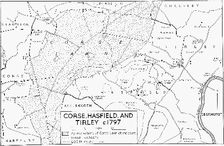
Corse, Hasfield and Tirley, c.1797
It was presumably because of the location of the church that the parish came to be called after Corse. A larger and apparently earlier settlement was at Oridge Street, where Domesday recorded a small estate at 'Tereige'. (fn. 31) Aldith of Oridge and Agnes of Oridge were parties to a lawsuit in 1221. (fn. 32) In 1248 the township of Oridge was fined, (fn. 33) as were the separate townships of Oridge and Corse in 1287. (fn. 34) Later, however, Oridge and Corse were both part of the same township, and Oridge was presumably represented by Woodrow (Wodereue) in the township called Woodrow and Corse in the tax assessment of 1327. (fn. 35) Woodrow would have been an apt name for a settlement that later formed a short street of houses on the edge of the chase. (fn. 36) In the early 18th century Oridge contained nearly a quarter of the houses in a parish of scattered settlement. (fn. 37) The houses there in 1966 were mostly of brick, built in the 18th, 19th, and 20th centuries, but there were also a timber-framed cottage, a small cruck-framed barn south of Corse House, and part of a timberframed barn at Buck Farm. The only other concentration of houses in the 18th century was on the north-west boundary of the parish, where the smaller part of the hamlet that centred on the cross-roads and the Swan Inn in Staunton was in Corse parish, (fn. 38) and known as Staunton End.
By the late 18th century the other houses in the parish were strung out along the western and northern edges of the Lawn. (fn. 39) North-east of the church were the vicarage (fn. 40) and Stone End House, a building deriving from the 17th century with a large 18th-century addition. Between Stone End House and Oridge Street there were three farm-houses at Oldfield Top, where in 1966 only one survived in use, built mainly in the 18th and 19th centuries. Between Oridge Street and Staunton End were four houses at Snig's End, which may have been the site of a house called Snig's Place in 1493, when it was said, however, to be in Staunton. (fn. 41) None of the surviving houses there is obviously older than the 18th century. A small group of houses established in the 18th century lay north-east at Newlands. One incorporates a small timber-framed structure apparently of the 17th century. From Pillows Green, (fn. 42) north-east of Staunton End, a widely spread line of houses ran along the north side of the Lawn; they included the Hawthorns (fn. 43) and some small 18th-century farm-houses, of brick or rendered brick, that survived in 1966. In 1796 many of the houses stood right on the edge of the uninclosed Lawn. There were also 10 houses, mostly small and on the east side of the parish, built on inclosures within the Lawn. (fn. 44) They included the Ledge, standing on a small spur below Corse Wood Hill and rebuilt in brick in the late 19th century, and Corner House, in the angle between the roads to Hasfield and Ashleworth, a tall brick house of the late 18th century.
Two things brought a change in the pattern of settlement in the earlier 19th century. One was inclosure of the Lawn, as a result of which seven new farm-houses were built in the centre and on the east side of the parish; to some extent the new farm-houses replaced older ones that were less conveniently placed in relation to the post-inclosure farms. Some of the small farm-houses on the edge of the Lawn, as at Oldfield Top and Newlands, were gradually abandoned, and over a long period of years scattered cottages both on the west side of the parish and on the old inclosure within the Lawn went out of use and were allowed to fall down, being marked in 1966 by wells, small closes, and a few ruined walls.
The second major change was the acquisition of the Snig's End estate by the National Land Company and the establishment of a Chartist settlement. Feargus O'Connor bought the estate, 268 a. lying partly in Staunton and partly in Corse, in 1847. It was the third of the Chartist estates, and not far from the estate at Lowbands in Redmarley D'Abitot. By 1848 a school-house and 85 cottages had been built, and the first houses were allotted to their tenants, with 3 or 4 a. each. (fn. 45) The singlestory brick cottages, of the same design as on other Chartist estates, have four rooms and a front with a central pediment or low gable. The school and about half the houses were in Corse, some arranged in crescents facing each other across a main road, others grouped less formally away from the road. The settlement was not a success, (fn. 46) and the tenants resisted paying their rent; (fn. 47) the National Land Company was dissolved under an Act of 1851. (fn. 48) In 1856 it was said that most of the occupants obtained their living by cultivating their allotments. (fn. 49) The building planned to include the school, and also, apparently, offices and communal rooms, is a onestory brick building with stone dressings and a central two-story gable, which gives it the appearance of one of the cottages enlarged and elaborated. By 1870 it had become a public house, the 'Prince of Wales', (fn. 50) and so remained in 1966.
The Newent Rural District Council built three pairs of houses under Corse Wood Hill soon after the Second World War, and an estate of c. 20 houses in 1961 on the boundary of Staunton and Corse at Snig's End. Several small houses, mainly bungalows, were built in the Snig's End area c. 1960.
Only 9 people were assessed for tax in 1327, and the assessment was relatively low. (fn. 51) In 1551 there were c. 130 communicants, (fn. 52) and in 1563 there were 39 households. (fn. 53) The population may then have fallen, for there were said to be only 100 communicants in 1603 (fn. 54) and 36 families in 1650. (fn. 55) By 1672, however, there were 60 houses including those exempted from paying hearth tax, (fn. 56) and c. 1710 there were said to be 65 houses and a population of c. 300. (fn. 57) The population may have fallen again, for in 1771 there were 253 inhabitants, (fn. 58) but by 1801, when the number of inhabited houses was the same as c. 1710, there were 335 inhabitants. The number rose steadily to 482 in 1841, and had jumped to 586 by 1851, largely because of the Chartist settlement, but from then until 1921 the population declined regularly each decade. In 1921, and in 1931, there were 337 inhabitants. The number had risen once more to 463 by 1961, (fn. 59) when a rapid increase was in progress because of the new housing estate.
The high road from Wickridge to Oridge was recorded c. 1242, (fn. 60) and the high road leading through the middle of Oridge c. 1300. (fn. 61) That road ran across Corse Chase; it is not clear whether the roads from Gloucester to Ledbury and Upton upon Severn also crossed the chase or skirted its edges, following the course of surviving minor roads. The bridge in the port street at Corse, which was out of repair in 1378, was apparently on the boundary of Corse and Staunton, (fn. 62) and is therefore likely to have been the one west of Oridge Street that crosses the Glynch brook on the road running near the west boundary of the parish. (fn. 63) If so, that road, and not the one across Corse Lawn, was then the main route. The road from Gloucester was turnpiked as far as the southern end of the Lawn in 1726, (fn. 64) and from there across the Lawn towards Ledbury one way and Upton the other in 1747. (fn. 65) The road connecting those two and forming the third side of a triangle was a turnpike from 1764 (fn. 66) until 1871, and acquired some importance as the route from Ledbury to the Haw Bridge; the others were disturnpiked in 1879. (fn. 67) The minor roads in the north of the parish include Gill Lane, recorded in 1293; (fn. 68) three others and those elsewhere on the Lawn follow the straight courses defined at inclosure. (fn. 69) The one called Green Lane, which replaced the old high road from Wickridge to Oridge, was closed as a road, though retained as a footpath, in 1875. (fn. 70)
An unlicensed victualling house was kept at Corse in 1601. (fn. 71) An alehouse suppressed in 1690 (fn. 72) may have been the one called the 'Buck' and kept at Buck Farm before 1691. (fn. 73) The alehouse licensed in 1755 (fn. 74) may have been the 'Feathers' at Staunton End, a stone house of the mid-18th century that was an inn until c. 1880 and later a farm-house, (fn. 75) and was demolished in 1965 to make way for a new house. (fn. 76) The 'Prince of Wales' is mentioned above. In the late 19th century and early 20th there was a branch of the Gloucester Co-operative Society at Snig's End. (fn. 77) A village hall was opened in 1956 on land given by the Hulls family, where there were also playing fields and a pavilion. (fn. 78)
Particularly after the establishment of the Chartist settlement, Corse was relatively populous for a rural parish, with a high proportion of people in the labouring classes. The farms were fairly small, and there was no squire. In 1865 the vicar, in appealing for help for the school, complained that there were scarcely any well-to-do people in the parish. (fn. 79) From the 1880's the doctors who lived at Corse Grange, formerly Snig's End House, were influential in local affairs; C. St. S. R. Nason was followed by J. E. St. G. Johnstone (d. 1958). (fn. 80)
Chase.
Corse Chase, which was closely connected with Malvern Chase, belonged to the Earls of Gloucester in the 12th century, (fn. 81) and was presumably part of the great manor of Tewkesbury, with which it descended until the 16th century. (fn. 82) By the early 14th century the chase was attached administratively to the earls' manor of Stoke Orchard, (fn. 83) a sub-manor of Tewkesbury. (fn. 84) It seems likely that the earls had no land in the area of Corse Chase, but only the right of hunting the game there and the associated right of preserving the woodland. That may underlie the statement in 1350 that there was no free chase of Corse, and that the earls had Corse Chase by usurpation and by encroachment of beasts from Malvern Chase. (fn. 85) If Corse Chase was held by usurpation, the usurpation was one of long standing, for before 1179 William, Earl of Gloucester, confirmed to the monks of Gloucester all their old and new assarts in Maisemore and Hartpury. (fn. 86) In 1199 land below Corse Wood was said to be in the forest of Malvern. (fn. 87) The earls' chase was referred to as the forest of Corse in 1262, (fn. 88) and in 1263 the forest of Corse was valued at little less than Malvern Forest. (fn. 89)
Corse Chase extended far beyond the parish of Corse. It appears to have included all that part of Gloucestershire lying between the rivers Severn and Leadon, for in 1350 Maisemore, Hartpury, Ashleworth, Hasfield, and Tirley were within the chase. (fn. 90) In addition, the chase extended into Worcestershire: on the boundary of Eldersfield and Chaceley there remains an uninclosed piece of Corse Lawn, the common which represented the unassarted area of the chase, and some of the freeholders of Staunton and Eldersfield successfully claimed right of common in Corse Lawn within the parish of Corse. In Staunton, the right was restricted to those with land east of the Glynch brook, (fn. 91) suggesting that the brook had at one time been the western boundary of the chase.
In 1212 Nicholas Lefward was said to hold 3 a. in Pull by serjeanty of keeping Corse Forest. (fn. 92) Walter the forester was recorded in 1221, (fn. 93) Gilbert of Corse, forester, between 1276 and 1287, (fn. 94) and Thomas the forester of Corse in 1285. (fn. 95) Reynold the forester in 1293 (fn. 96) may have been the same as Reynold the woodward in 1306. (fn. 97) In 1276 the Earl of Gloucester had three foresters in Corse, of whom it was complained that they arrested men in Gloucestershire and imprisoned them in Worcestershire without trial, and that they had caused a man to be beheaded for stealing sheep without trial. It was also alleged that the earl's steward exacted a fine in the townships adjoining Corse Wood for the lawing of dogs, not only from those with dogs but also from those who had none, and that the foresters appropriated warren outside the cover of the wood in places where the earl had no fee or tenement. (fn. 98) In 1321, (fn. 99) and in 1350 when there was a head forester and three others, the foresters were paid out of the issues of Tewkesbury manor; (fn. 100) in 1378 the four foresters were paid out of the issues of Stoke Orchard manor. (fn. 101) The offices of two of the underforesters may have been represented by those of keeper of the middle bailiwick and forester of Charlewood, both said to be within the chase of Corse Lawn and recorded in 1478. (fn. 102) In 1330 John of Longdon was appointed chief rider of the chase. (fn. 103)
The head forester's office may have been the same as that of keeper. Several keepers are recorded: William de Beauchamp (appointed 1321), Alexander de Lilleford (in 1326), John Devereux (appointed 1327), William of Matson (appointed 1330), Robert of Apperley (in 1345), John de Beauchamp (appointed 1349), Robert Whittington (appointed for life 1400, in succession to Nicholas of Apperley), and Richard Beauchamp, Lord Beauchamp (appointed 1478). In 1321, 1326, 1330, and 1478 the keeperships of Corse Chase and Malvern Chase were held together. (fn. 104) John Savage was master or keeper of Corse Lawn Chase from 1495 to 1521, (fn. 105) and Anthony Kingston was appointed master in 1536. (fn. 106) Henry Jerningham, the owner of Tewkesbury Park, succeeded Kingston in 1556. (fn. 107) The chief woodward and his deputy were named in 1615. (fn. 108) Before 1628 Sir William Throckmorton, Bt., lord of Corse Court in Tirley, sold the office of master to Sir Richard Tracy, Bt., lord of Hasfield (d. 1637), (fn. 109) who was recorded as master of the deer in Corse Lawn in 1631. (fn. 110) In 1638 Richard Horsham and Richard Jelf were described as two of the keepers of the deer of Corse Lawn under the Earl of Middlesex, the owner of the chase. (fn. 111) No later record of officers of the chase has been found. In 1287 there was a reference to the Abbot of Westminster's chase of Corse, when the office of keeping the wood of that chase was conveyed to or settled on Nicholas of Apperley, (fn. 112) but it is unlikely to have indicated that the abbot had any rights of hunting. Similarly, a complaint c. 1374 of encroachment by the officers of Malvern Chase on the abbot's wood of Corse, (fn. 113) appears to relate to damage affecting timber or pasture, not to interference with game.
Corse Chase, which with Tewkesbury manor was granted by the Crown in 1547 to Thomas Seymour, Lord Seymour of Sudeley, and was afterwards forfeited, (fn. 114) was in 1629 granted by the Crown in trust for Lionel Cranfield, Earl of Middlesex. (fn. 115) In 1628 there were still deer in the chase in considerable numbers, (fn. 116) and in 1631 and 1638 efforts were made to prevent poaching and preserve the cover. (fn. 117) In 1662 the younger Lionel Cranfield, Earl of Middlesex, claimed 'some interest' in Corse Lawn by virtue of the grant to his father, (fn. 118) but no later record has been found of the ownership of the chase. The chase may have passed to the Dowdeswells of Pull Court, owners of one manor of Corse and lessees of the other, (fn. 119) for their muniments included a roll of the court of Corse Chase in 1615. (fn. 120)
The roll of 1615 is the only one known to survive from the court. The court was held at Witcombe Gate (fn. 121) near the eastern boundary of the parish towards Wickridge Street. In the late 18th century it was said that all the inhabitants of the adjoining parishes had been suitors. (fn. 122) The court was presumably the same as that of Woodley Stile, recorded in the later 13th century when the Earl of Gloucester confirmed that the Abbot of Gloucester owed no suit to that court for his manor of Maisemore. (fn. 123) The court of 1615 made presentments of offences against the vert, and made orders to restrict both the commoners' rights in collecting fuel and pasturing animals and the woodward's rights in confiscating edge-tools. (fn. 124)
Manors and Other Estates.
The bounds of an estate west of the Severn that belonged to Westminster Abbey in the 11th century, and had presumably belonged earlier to the monastery at Deerhurst, included the whole area of Corse parish. (fn. 125) Westminster Abbey's estate in Corse was represented in Domesday by the ½ hide at Oridge Street (Tereige) held by Lewin; any other land in Corse was presumably entered simply as part of the abbey's manor of Deerhurst. (fn. 126) Corse was one of the members of Deerhurst manor which William de Derneford surrendered with Deerhurst manor to Westminster Abbey in 1299; (fn. 127) William had held Corse under the grant of 1192 by the abbey to his namesake, (fn. 128) and in 1284 he had granted holdings in his wood called Corse Woods Moor and in Oridge to his son John. (fn. 129) From 1299 Westminster Abbey retained what was called, in the abbey's refoundation grants of 1542, 1556, and 1560, the manor of CORSE LAWN. (fn. 130) By the 16th century the abbey appears to have had no demesne in Corse, and in 1649 the manor consisted of the rents of freehold and copyhold tenants. (fn. 131) The manor was leased, (fn. 132) and from 1641 until inclosure the lessees were the members of the Dowdeswell family (fn. 133) that from 1651 were the lords of the other manor in Corse parish. (fn. 134) At inclosure in 1796 and 1797 the abbey received 56 a. in place of its manorial rights in Corse. (fn. 135) The abbey's ownership of land in Corse appears to have ended in 1868 with the enfranchisement of a leasehold estate. (fn. 136)
Another manor in the parish, later called variously CORSE, CORSE LAWN, WITCOMBE, WITCOMBE GATE, (fn. 137) and CORSE CHASE (fn. 138) manor, appears to have derived from the manor of Corse confirmed in 1281 to Gilbert of Corse, the forester, by Walter of Aston Subedge. (fn. 139) The manor, which was presumably a sub-manor of the abbey's, is not subsequently recorded until the end of the Middle Ages, but it may have been the home of William Butler of Corse between 1390 and 1450 (fn. 140) and of John Butler of Corse in 1455. (fn. 141) A wood in the east of the parish was called Butler's Oak in 1584. (fn. 142) In 1491 Corse manor was among the possessions of Thomas Whittington of Upper Lypiatt, (fn. 143) and it afterwards passed to Robert Wye, the son of Whittington's daughter, Maud, and her husband, William Wye. (fn. 144) Robert Wye died in 1544, (fn. 145) and his wife Jane received a life-interest in Corse manor under the terms of his will. (fn. 146) Robert's son and heir Thomas, (fn. 147) who was sheriff of Gloucester in 1575, (fn. 148) died c. 1580, and his wife Gillian, who had a life-interest in the manor, married John Throckmorton. (fn. 149) John Throckmorton evidently acquired the reversion also, and in 1592 he made a settlement of the manor. (fn. 150) He or his nephew was named as lord of Corse in 1608 ; (fn. 151) the elder John Throckmorton was succeeded by his brother George, whose son John sold the manor in 1651 to Richard Dowdeswell of Pull Court, in Bushley (Worcs.). (fn. 152)
The manor then descended in the Dowdeswell family for 250 years. It passed to successive eldest sons from Richard (d. 1673), William (d. 1683), Richard (d. 1711), William (d. 1728), and William Dowdeswell, Chancellor of the Exchequer (d. 1775), whose son Thomas (d. 1811) (fn. 153) received 44 a. for his manorial rights at inclosure in 1796 and 1797, (fn. 154) and was succeeded by two of his brothers in turn, William (d. 1828) and John Edmund (d. 1851). John Edmund was succeeded by his son William (d. 1887) and by William's son William Edmund (d. 1893), whose brother, the Revd. Edmund Richard Dowdeswell, (fn. 155) was recorded as lord of the manor in 1906, but not in 1910. (fn. 156)
From the late 16th century it seems that the land of the manor belonging to the Throckmortons and Dowdeswells was, like that of Westminster Abbey, held entirely by freehold, leasehold, and copyhold tenants. The manor-house was alienated in 1592 by John Throckmorton. (fn. 157) From later evidence it is clear that it was the house standing close to the church, afterwards known as Corse Farm, and in 1966 as Corse Court; in 1584 it was apparently the house of the 'manor or farm of Corse Church'. (fn. 158) The purchaser in 1592 was James Cooke of Corse; (fn. 159) perhaps his son was the James Cooke who sold Corse farm in 1648 to Mark Grimes. Grimes sold in 1664 to Rice Yate (fn. 160) (d. 1690) of Bromsberrow, whose daughter Catherine (d. 1757) married Robert Dobyns. Their grandson, Robert, son of another Robert Dobyns, took the additional surname Yate, and his son, Robert Gorges Dobyns Yate (d. 1785), (fn. 161) sold the estate to Samuel Wilson of Gloucester. Under Wilson's will (fn. 162) the estate was held in 1796 by Elizabeth Wood (fn. 163) and in 1797, when it amounted to 256 a., by James Wood (fn. 164) (d. 1836), the Gloucester banker. (fn. 165) Wood's trustees had sold the estate in several lots by 1863. The part including Stone End House was bought by John Butler, in whose family it remained (fn. 166) in 1966. In 1911 Corse Farm was bought by William Houldey, the existing tenant, and in 1961, when a new house was built for the farmer, by Mr. C. A. Barrett. (fn. 167)
The house stands close to the church near the southern boundary of the parish on a large site once enclosed by a moat that was partly visible in 1966, and incorporates a cruck-framed hall of the 14th century. Four pairs of crucks survive in whole or in part; the central and northern bays, of c. 12 ft. each, once formed an open hall, and the cruck-truss dividing them has a cambered, arch-braced collar, with an ogee cut in the collar and cusping in the cruck-blades above the collar. The pair of cruckblades between the central and southern bays had simpler trussing, indicating that the 16-ft. southern bay was not part of the hall. East and west doorways at the south end of the hall may mark the position of the screens passage. In the roof the original purlins survive, sprocketted on to the cruck-blades and braced by large, curved wind-braces; the roof shows traces of a smoke-hole at the ridge. At the north end of the hall are a doorway, the lintel cut with an ogee, and two of three bays of plaster-filled arcading with wooden ogee spandrels. The cruck-truss at the north end has been considerably modified, and the solar wing that presumably stood beyond it was replaced by a two-story cross-wing, of which the gable is jettied at first-floor level. An upper floor and a stone chimney-stack were inserted in the hall in the 16th or 17th century. The house was later extended by a further bay on the south, partly in rubble, and underwent considerable alterations c. 1900. The alterations included the removal of a plaster coat-of-arms of the Wood family from over the east doorway to the gable-end of the cross-wing. In 1961 the house was badly out of repair, and extensive renovation, which included retiling, was carried out in the next few years. (fn. 168)
Little Malvern Priory acquired a holding in Oridge Street under the will of Thomas Whittington, dated 1491, (fn. 169) and in 1535 rents of 10s. owed to the priory were said to be of tenants in Corse Lawn. (fn. 170) In 1545 the Crown granted the priory's estate in Oridge Street to Henry Lee. (fn. 171)
In the late 13th century William de Derneford granted a house and garden in Gillcroft, by Gill Lane, apparently to Henry son of Robert Tony of Bromsberrow, who in 1293 granted them to William son of Henry the smith of Eldersfield. (fn. 172) The house and garden appear to have been the nucleus of the lands and tenements in Corse and Eldersfield which William Gill of Corse conveyed to John Wither of Eldersfield in 1372. (fn. 173) In 1417 Wither gave the reversion to John Wigmore of Hasfield, (fn. 174) who in 1452 conveyed Gill's tenement to Richard Moore and Thomas Rastell; in 1454 Wigmore's niece and heir, Alice, with her husband Thomas Gilbert, conveyed her interest in an estate in Corse and Eldersfield to a group of trustees. (fn. 175) The occurrence of Thomas Rastell suggests that the estate may have passed, through John Rastell who c. 1530 was renting land in Corse, (fn. 176) to Christopher Rastell, who died in 1564 holding an estate of Thomas Wye. (fn. 177) It is also possible that it was the estate in Corse and Eldersfield which John Collins alleged in 1609 had belonged to his father Christopher and had passed by fraud to Christopher's younger son William. (fn. 178) A William Collins in 1641 conveyed his estate in Corse and Eldersfield to Thomas Browne, (fn. 179) who in 1649 owed chief-rents to Westminster Abbey for two freeholds in Corse. (fn. 180) Browne was succeeded in 1670 by his son Thomas, who by 1710 had in turn been succeeded by his son Thomas. The Brownes' estate by then included a house called Poulton Place, (fn. 181) apparently after a family called Poulton recorded in Corse in 1563 and 1643. (fn. 182) The Brownes' house, with 6 hearths the largest recorded in the parish in 1672, (fn. 183) was apparently the Hawthorns, which by 1790 belonged to William Hawkins, (fn. 184) the husband of Anne Wood, sole executrix of the will of Elizabeth Browne (d. 1784). (fn. 185) In 1797 the Hawkins estate included 153 a. in Corse. (fn. 186) Another William Hawkins, son or grandson of William and Anne, was succeeded in 1847 by his son William, (fn. 187) and the estate remained in the ownership of the Hawkins family until the late 19th century, (fn. 188) when it was put up for sale several times. (fn. 189) By 1914 it was owned and occupied by Norton Padfield, (fn. 190) and in 1966 belonged to his son Mr. R. N. Padfield. (fn. 191)
The Hawthorns stands near the northern edge of the parish within a moat of which two sides remained visible in 1966. The house appears to have been rebuilt in the early 17th century as a timber-framed structure. The main two-story block has a west front which has been considerably altered; the timbers are untarred, and the lower part was formerly close-studded. A cross-wing at the south end contains a stair-well with an early 17th-century staircase running up to the gabled second floor. Small panes of old glass in the house are painted with the date 1627 and the letter B. Internally the house was altered in the late 17th century and early 19th, but retains, apart from posts and beams, some of the early 17th-century woodwork. In the later 17th century a wing of square framing, with mullioned windows, was built across the north end, and apparently in the early 19th century the southern wing was cased in brick. The house is similar in several respects to that at Great Cumberwood, which is dated 1627 and belonged to another branch of the Browne family. (fn. 192)
Economic History.
Before the inclosure of Corse Lawn at the end of the 18th century, twothirds of the area of the parish was uninclosed land, (fn. 193) undrained and not available for cultivation, so that Corse was a pastoral rather than an agricultural parish. Twenty years before inclosure the Lawn was said to be common to the parishioners, who depended on pasturing sheep upon it, but that they were often ruined because in a wet season hardly any sheep survived the rot. (fn. 194) In a broadsheet advocating inclosure, the parishioners of Corse alleged that they were mainly cottagers who were unable to keep sheep other than on the Lawn, whereas rich farmers of neighbouring parishes, who could keep their sheep elsewhere in a wet season, put too many sheep on the Lawn. (fn. 195) Although the court of Corse Chase in 1615 prohibited the commoning of sheep before 3 May and limited the stint thereafter to half the number which a commoner could winter on his tenement, (fn. 196) there appears to have been no effective restriction on numbers, and the theory that confined a commoner's rights to the unmarked bounds of his own parish was clearly impracticable. (fn. 197) Many of the commoners lived in small houses built by encroachment, (fn. 198) and the exercise of their supposed rights of common of pasture was unregulated and incapable of improvement without wholesale inclosure.
Some cultivable land, however, had been won by early assarts of woodland and later encroachments, licensed and unlicensed, (fn. 199) on Corse Lawn. Some of the cultivable land lay in open fields, and Corse field was recorded in the early 13th century as an open field subject to common of pasture. (fn. 200) In the late 14th century Nicholas of Apperley's estate included 40 a. of arable and 8 a. of meadow in Corse, (fn. 201) and in 1535 the more valuable part of the vicar's tithes was of corn and hay. (fn. 202) In 1584 three common and open fields were recorded: Haw field lay apparently north of Oridge Street, (fn. 203) running down to a meadow beside the Glynch brook; (fn. 204) Stone Redding field lay southwest of Oridge Street, on the edge of the parish; (fn. 205) and Pease Croft field lay south-east of the church. None of the three fields appears to have been large. In addition the field called Old field in 1584 (the name of which survives in the name Old Field Top) was apparently a former open field that had already been inclosed. (fn. 206) At Old Field Top some ridge and furrow survives in orchards. By 1677 Pease Croft field was mainly in a single ownership. (fn. 207) Prestley, or Presty, common field, recorded in 1684 and 1693, apparently lay in the north of the parish; (fn. 208) it may have been part of Haw field. By 1796 all of the openfield land had been inclosed except for something under 20 a. of Stone Redding field, which was inclosed by the first inclosure award for Corse Lawn. (fn. 209)
In the 16th and 17th centuries some of the land was held by copyhold. John Throckmorton enfranchised a copyhold in 1597; (fn. 210) in 1649 the Westminster Abbey manor, which then had 16 freeholders owing rents and reliefs, had 3 copyholders owing rents and heriots. (fn. 211) In 1794 two small copyholds survived; (fn. 212) in 1796 Thomas Dowdeswell, as lessee of the abbey's manor, was said to have power to receive the surrender of copyholds and to grant copyholds, but all those who received inclosure allotments, both in the abbey's manor and in the Dowdeswells' manor, were either freeholders or leaseholders. (fn. 213) The crops grown on the cultivated land included large quantities of fruit, (fn. 214) and in 1705 a list of tithable produce placed cider and perry before corn and hay. (fn. 215) In the 18th century hops were also grown, but their cultivation was abandoned. (fn. 216) Before inclosure, 'vast crops' of grain were said to be grown on encroachments on Corse Lawn. (fn. 217)
Some of the encroachments were held under lease from Thomas Dowdeswell, with the written consent of the greater part of the freeholders, whose commoning rights were in theory diminished by the encroachments. Others, and particularly the older ones, had been made without the authority of a manorial lord or the consent of the freeholders. In 1785 Thomas Dowdeswell's steward and two or three of the freeholders pulled down the fences of the unauthorized inclosures; thus encouraged, the freeholders went on to pull down also the fences of encroachments made under lease. The lessees and squatters rebuilt their fences, and the squatters took steps to strengthen their title. (fn. 218)
That activity was a prelude to parliamentary inclosure. Those who claimed rights in Corse Lawn by virtue of holdings in Corse parish were the two lords of manors, the vicar, and 51 others, of whom 14 owned or leased only cottages and gardens worth under £4 a year. (fn. 219) Apart from the competing claims of the two manors (fn. 220) and the question of title to encroachments, the claims of landholders in other parishes to common in Corse Lawn (and therefore in Corse parish) complicated the process of inclosure. (fn. 221) The freeholders of land in Staunton east of the Glynch brook claimed common on the Lawn as fully as the freeholders of Corse had it. When the inclosure bill was at an advanced stage they secured, although they had yet to establish their claim, the insertion of a clause (fn. 222) under which the commissioners, in their award of 1796, made a conditional allotment of 513 a. for the Staunton freeholders in general. The claim, though rejected by the commissioners, was upheld in court, and under a second Act the commissioners made a second award. By that time some landowners in Eldersfield had put in a claim to compensation, which was not resisted, and because no land had been set aside for them the second award compensated them with money payments totalling £2,703 net and raised with the other expenses of inclosure. In all, the commissioners allotted 1,288 a., excluding land allotted for roads, stonepits, and a pound, among 66 owners. Five owners received 100 a. or more, 6 received between 20 and 100 a., and 16 received under 3 a. In addition, the tithes were commuted by allotments of land and, on some of the old inclosures, by corn rents. (fn. 223)
After the inclosure of Corse Lawn much of the land was ploughed and yielded large crops of cereals. (fn. 224) In 1864 two of the larger farms on the former Lawn were predominantly arable, whereas one in the same ownership on old-inclosed land was predominantly pasture. (fn. 225) In 1870 wheat, barley, beans, and peas were named along with cider and perry fruit as the chief crops. (fn. 226) By 1901, however, three-quarters of the farm-land was permanent grass. (fn. 227) In 1831 there were 25 agricultural occupiers, of whom 12 employed no labour. (fn. 228) The number apparently fell later in the century and settled at c. 20. (fn. 229) In the mid-20th century most of the farms raised beef or dairy cattle, with a few sheep. The National Land Company, in acquiring the Snig's End estate, sought to settle a number of smallholders in Corse and Staunton, (fn. 230) and several of the Snig's End allotments continued to be used as smallholdings in the mid-20th century. (fn. 231)
Few inhabitants seem to have practised trades or handicrafts before the 19th century. There was a mill at Corse Lawn in 1790, (fn. 232) but no other certain record of it has been found. (fn. 233) The descendants of Henry the smith of Eldersfield may have followed his trade in Corse in the 14th century. (fn. 234) In 1608 a tailor and two weavers were recorded at Corse. (fn. 235) Less than one-fifth of the population was supported by trade or manufacture in the early 19th century. (fn. 236) Later, as in most parishes, there were butchers, bakers, builders, carpenters, wheelwrights, and blacksmiths. (fn. 237) It is likely that the rise in the number of small tradesmen was partly the result of the settlement of former town-dwellers on the Snig's End estate and the failure of the National Land Company.
Local Government.
Before the late 18th century there is no record of a court attached to either manor of Corse, and the only court known is that of Woodley Stile, held for Corse Chase at Witcombe Gate, mentioned above. (fn. 238) A court baron was held c. 1784 for the Dowdeswell manor, but no court had been held for many years before and the rolls were said to have been lost. The inhabitants owed suit to the hundred court of Westminster at Plaistow in Deerhurst, where a constable and hayward were appointed. (fn. 239)
In 1794 one of the two churchwardens was nominated by the vicar, and there were four overseers. The parish subscribed to the Gloucester Infirmary, and up to 1795 the poor of Corse were relieved partly in the Staunton parish workhouse. (fn. 240) That may account for the fall in expenditure on poor relief between 1776 and 1785, but in 1803, when 10 people received regular relief and none were in a workhouse, expenditure was no greater than in 1776. (fn. 241) In the next ten years, however, it rose from under £100 to over £200 a year. (fn. 242) In 1807 the overseers were paying a Gloucester surgeon to attend the poor, and later on they paid the rents of some of the poor. Although there is no evidence of a salaried overseer, there was a salaried surveyor of highways by 1829. (fn. 243)
The parish became part of the Newent Poor Law Union in 1835, (fn. 244) and remained in the Newent Rural District in 1966. The parish council met regularly in 1966; its financial needs were met from the rent of the former parish pound, (fn. 245) built at Snig's End in 1796 (fn. 246) and used by the county council to park vehicles in 1966.
Church.
The closeness of the church to the moated manor-house called Corse Court suggests that the church may owe its foundation to the occupants of that house. Although the font is of the 12th century (fn. 247) no other part of the fabric of the church can be identified as earlier than the 14th century. The earliest surviving documentary reference to the church is of 1290, when the Prior of Deerhurst was patron of Corse church. (fn. 248) His patronage reflects the fact that Corse had been part of the large area served by Deerhurst priory church.
Although in 1290 the living may have been a rectory, (fn. 249) in 1311 there was a vicarage. (fn. 250) The dependence of Corse church on Deerhurst was signified by the word chapel, used in 1312 (fn. 251) and as late as 1384, (fn. 252) and in 1362 what was evidently the parish church was mentioned as the chantry chapel of Corse. (fn. 253) The living remained a vicarage from the early 14th century until 1952, when the benefices of Corse and Staunton were united, the parishes remaining distinct. (fn. 254) The advowson remained with Deerhurst Priory (fn. 255) until the Dissolution, being exercised by the Crown on several occasions in time of war (fn. 256) and passing to Tewkesbury Abbey with the rest of the priory in the 15th century. In 1539 the abbey made a grant of the next presentation, which was exercised in 1554. The Crown presented to the living in 1576 (fn. 257) and retained the patronage (fn. 258) until c. 1930, when the Bishop of Gloucester became patron. (fn. 259) After the union with Staunton the bishop had alternate turns.
In or before 1370 the vicar, John Leominster, brought an action in court against the prior of Deerhurst for the augmentation of his living. (fn. 260) The vicarage at the time was presumably endowed with a portion of the tithes. In 1535 the vicar had glebe amounting to 6 a., some tithes of corn and hay, and the small tithes; the whole was valued at £6 7s. 9d. a year. The rectory was said to be appropriated to Tewkesbury Abbey, (fn. 261) but there is no evidence that the abbey received any profits from Corse church. Since by 1677 the vicar received all the tithes of the parish, (fn. 262) it is possible that he already did so in 1535. Between 1535 and 1584, however, the vicar's glebe had increased to c. 20 a., (fn. 263) so that, alternatively, his tithes may also have been augmented in the same period. The vicarage was valued at £35 a year in 1650, (fn. 264) £50 c. 1710, (fn. 265) and £70 c. 1775. (fn. 266) At inclosure in 1796 and 1797 the vicar received an allotment of 177 a. for some of his tithes and his rights of common, and corn rents of £141 for the tithes of some of the old inclosures. (fn. 267) The living was valued at over £400 a year in the mid-19th century, and at £350 in 1923. (fn. 268) The vicar's house was called a mansion house in 1584, (fn. 269) and in 1680 it had four lower, four upper rooms, and a garret. (fn. 270) A new house was built between 1765 and 1790, apparently on the site of the old one, and was said to be very commodious. (fn. 271) It is a tall brick house of three stories and attics, 400 yds. north-east of the church, and it remained the vicarage until 1952. (fn. 272) Its principal front has a pedimented doorway and a Venetian window above.
Robert de Colevill, instituted to the vicarage in 1311, (fn. 273) was deprived as an unsuitable person, and his successor, Walter of Little Rissington, whom the bishop collated to the living in 1312, was deprived in 1313 for non-residence. (fn. 274) Edmund Jones, vicar in 1532, (fn. 275) was replaced in 1554, (fn. 276) but was once again vicar, and resident, in 1563. (fn. 277) He resigned in 1576, to be followed as vicar by his son Robert, (fn. 278) who was still vicar in 1603. (fn. 279) Edmund did not do well in the bishop's doctrinal test of 1551; (fn. 280) Robert was reported as neither a graduate nor a preacher in 1584, (fn. 281) but in 1593 was classified as a sufficient scholar though not a preacher. (fn. 282) Simon Jones, who was presented for making unlawful marriages in 1631 and 1637, (fn. 283) may have been unconnected with Edmund and Robert, but he was presumably the 'preaching minister' serving Corse in 1650. (fn. 284) Thomas Pembrugg, who became vicar at the Restoration, was one of a local gentry family and was also Vicar of Hartpury. (fn. 285) Charles Smith, instituted to the vicarage in 1699, was also Vicar of Ashleworth and was non-resident; (fn. 286) the curate serving Corse, James Chew, (fn. 287) succeeded him as vicar, 1716–27. (fn. 288) For most of the 18th century Corse had a father and son as vicars: Joseph Gegg, 1727–65, who was also Vicar of Ashleworth, where he lived, and Robert Gegg, 1765–93, who built the new vicarage at Corse and lived there. (fn. 289) Edward Jones, vicar 1793–1828, lived in Gloucester and was also Vicar of Rudford; he employed curates to serve Corse. (fn. 290) Two of the later vicars who held the living for long periods were influential in the parish, A. H. Wyatt, 1869–1906, and James Beckley, 1928– 1952. From 1952 the incumbents lived at Staunton. (fn. 291)
The church of ST. MARGARET (fn. 292) is of stone with a roof partly of Cotswold stone slates and partly of Welsh slates, and comprises chancel, nave, north and south porches, and western tower with spire. Most of the fabric of the church derives from the late 14th century; in 1857 the church was said to be in good order. (fn. 293) Later restoration, done partly if not exclusively in 1913, (fn. 294) was unobtrusive. The nave is built of considerably larger stones than the chancel and has a plinth, which is missing from the chancel. The chancel has a trussed rafter roof, and the roof of the nave, which is plastered and has a single, moulded tie-beam, may be similar. The three-light east window has restored 15th-century tracery, and the four windows in the side walls of the nave and chancel are of two 15th-century lights. The north porch is of open timber framing and appears to be of c. 1500. The south porch, of stone, was used as a porch in 1791 (fn. 295) but later became a vestry. The tower, of three stages with an ashlar-covered broach spire and diagonal buttresses, is of the 14th century. There is a stair-turret on the north side. One of the louvered windows to the bell-chamber was added in the 15th century or later. The finial of the spire has been renewed; the original crocketted finial, much weathered, stands in the churchyard.
One of the bells is of the late 16th century, and three are of the 17th. In 1907 the four bells were recast and two trebles added. (fn. 296) In the tower in 1966 there was an ancient chest, and the altar-table is 17th-century. The 12th-century font has scallops below the bowl and a band of cable ornament. The windows contain fragments of ancient glass. (fn. 297) The plate is of the early 19th century; (fn. 298) the registers begin in 1661, though there are some earlier transcripts. (fn. 299)
A charitable endowment, once used partly for church purposes but afterwards purely eleemosynary, is discussed below.
Nonconformity.
Apart from a disturbance in church in 1616 which appears to have had a doctrinal cause, (fn. 300) and references to marriages illegally performed, (fn. 301) the earliest record of nonconformity in the parish relates to Quaker burials there. Sarah, the wife of Mark Grimes, who owned Corse Farm (later Corse Court) (fn. 302) and in whose house in Gloucester George Fox held meetings, was buried at Corse in 1660, (fn. 303) presumably in the burial ground adjoining the churchyard that was conveyed to trustees in 1678. (fn. 304) The use of the burial ground by Quakers does not necessarily imply that there were Quakers living in the parish, and the return of 1676 recorded no nonconformist there. (fn. 305) Twelve Quakers were buried in Corse in the period 1700–9, and the ground may still have been in use c. 1775. (fn. 306) It seems to have gone out of use by 1785, and had certainly done so by 1821. (fn. 307) The meeting-house recorded in 1797 (fn. 308) was probably a mistake for a small building connected with the burial ground; a Quaker meetinghouse in Corse is not otherwise recorded. The burial ground, on the east side of the churchyard, (fn. 309) was later included in the churchyard.
A house was licensed for dissenting worship in 1747. (fn. 310) A Wesleyan chapel was built in 1838 (fn. 311) north of the Staunton cross-roads; it is a plain building of stone and rendered rubble that went out of use c. 1956. (fn. 312) A room in a private house was registered for dissenting worship in 1850. (fn. 313)
Schools.
There was no school in the parish in 1818, (fn. 314) 1825, (fn. 315) or 1833, when 22 children from Corse went to school in Eldersfield. (fn. 316) There was still no school in 1846, when it was said that one was needed for 70 children. (fn. 317) Although the 'Prince of Wales' was planned as a building to include a school for the Snig's End estate, (fn. 318) there is unlikely to have been a school there for long, if at all. A National school was established in 1856, (fn. 319) and its original site may have been at the Cross Hands, where there was once a school on glebe land. (fn. 320) In 1872, however, a new school was built at Snig's End. (fn. 321) The building is of stone in a Gothic style, comprising a schoolroom, a classroom, and a teacher's house. (fn. 322) A prefabricated classroom was added after the Second World War. Attendance, 103 in 1906 and 64 in 1936, (fn. 323) was c. 35 in 1966. The older children then went to Newent. (fn. 324)
Charities.
In 1683 the parish had three houses, given so long before that the donor was not remembered by name, from which the rent was used to buy communion bread and wine, and the remainder spent on poor-relief. (fn. 325) In the early 18th century the rent was said to be used also for the repair of the church. The total income was then £5 4s. a year. (fn. 326) By 1827 the three houses were divided into seven dwellings and let to the poor at low rents, while the land belonging to the houses was let at £20 a year. The total income of £24 was spent on coal for distribution to the poor. (fn. 327) The houses and land were sold after 1918. In 1966 the income of £28 from stock was spent mainly on coal, (fn. 328) in accordance with a Scheme of 1918 regulating the charity. (fn. 329) Francis Bayley's gift, at an unknown date, of a 12s. rent-charge for bread, which in 1827 had been revived after a period of neglect, (fn. 330) was paid as a rent-charge in 1966 for bread for old people. (fn. 331)