A History of the County of Somerset: Volume 3. Originally published by Victoria County History, London, 1974.
This free content was digitised by double rekeying. All rights reserved.
'Parishes: Stoke sub Hamdon', in A History of the County of Somerset: Volume 3, (London, 1974) pp. 235-249. British History Online https://www.british-history.ac.uk/vch/som/vol3/pp235-249 [accessed 12 April 2024]
In this section
STOKE SUB HAMDON
The ancient parish of Stoke sub Hamdon, commonly called Stoke under Ham, covers 1,381 a. (fn. 1) It lies 5 miles west of Yeovil, between Montacute and the Foss Way, and measures nearly 3 miles from east to west, and 1½ mile from north to south. The Foss Way forms the whole of its north-western boundary, and Trutts brook and Wellham's brook bound the parish on the north-east. Its southern limits are less easily defined, though they follow a lane from the Yeovil road up Hedgecock hill. This boundary was marked at its northern end by a stone, (fn. 2) and the hill itself was divided from neighbouring Montacute by a ditch, and from the time of Sir Edward Phelips (d. 1614) by a wall, (fn. 3) 'ruinous' by 1786. (fn. 4) It then follows the northern defences of the encampment on Ham or Hamdon Hill. From there the boundary runs westwards, a stream dividing Stoke from Norton sub Hamdon until it reaches the Parrett. (fn. 5) The original course of the river to Petherton Bridge forms Stoke's south-western boundary.
The dominant physical feature of the parish is Ham Hill, rising abruptly some 200 ft. immediately south of the village, to a total height of 400 ft. The hill itself is of Yeovil sands, capped by shelly limestone known as Ham stone, widely used in the district and elsewhere for building. (fn. 6) The steep sides and worked-out quarries formed the largest area of common land in the parish. The land falls away gently from the settlement at the foot of the scarp: westwards, towards the Parrett, a junction bed of limestone is followed by Pennard sands, reaching the river below 75 ft. Northwards, too, the land falls away, with a similar geological sequence of limestone, junction bed, and Pennard sands, followed by silts and marls which formed the main area of meadow in the parish. To the north-west alluvium is encountered near Wellham's brook. (fn. 7)
The main artery of the parish is the east–west road from Yeovil and Montacute, which follows the 200-ft. contour below Ham Hill through East and West Stoke and joins the Foss Way just short of Petherton Bridge. This is now variously called along its course East Stoke, High Street, and West Street, though in the late 18th century it was known as Church, Upper, and West streets. (fn. 8) From this a number of roads and lanes lead north and south, the most important of which is North Street, from the centre of West Stoke to Cartgate on the Foss Way. This was known as Lower Street in 1776 and a cross stood at its junction with Upper Street. (fn. 9) Castle Street, formerly Stone or Stone's Lane, (fn. 10) runs eastwards from North Street, parallel with High Street, passing the site of the castle. Wherlygog Lane was so named in 1776. (fn. 11)
Eastwards from the Vicarage the road divides, forming an island around which the settlement of East Stoke is situated. The southern and higher branch is the course of the Yeovil road, passing the church. The by-road to the church itself marks the original course, which was abandoned for the present one in 1841. (fn. 12) The northern branch of the road, known as Lower East Stoke Street in 1776, and in 1968 as Windsor Lane, originally ran further eastwards past East Stoke Farm and directly beside East Stoke House. It was diverted to its present course in 1883, the original road becoming a private driveway. (fn. 13) Since 1883 Marsh Lane has been joined to Mulberry Lane to divert traffic from East Stoke House. (fn. 14) South of the main artery the road to Odcombe, climbing from High Street to the summit of Ham Hill, was in the 18th century the London-Exeter coach road. (fn. 15) There was a plan c. 1822 to adopt a narrow strip of land parallel to and west of this road as part of a projected turnpike road from Cartgate to Merriott. (fn. 16) The plan did not then materialize, but a road was made there in 1898, known first as New Road and later as Norton Road, linking Stoke with Norton sub Hamdon. (fn. 17) Further west, at Holy Tree Cross, is a road to Chiselborough and Norton from the Foss Way. It is known at its northern end as Prophets Lane (Provost Lane in 1838), (fn. 18) and south of the cross roads as Holy Field Lane where it borders the former arable Holloway field. (fn. 19)
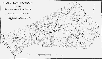
Stoke sub Hamdon, 1776
Most of the small tracks serving the open fields disappeared after inclosure. (fn. 20) One right of way traceable in the later 18th century was the procession way, the route taken by the triennial manorial perambulation. Field names such as Procession Orchard mark its course. The perambulation was still walked in 1775, but by 1809 it had lapsed. Land in Rixon Common was held in return for supplying beer and victuals for the perambulation, and closes on the parish boundary adjoining Holloway field were known as Victuals Hams. (fn. 21)
The Iron Age encampment on Ham Hill, part of which protrudes into the southern edge of the parish, is apparently the oldest settlement site in Stoke, though any direct relationship between it and the village below the scarp is not proved. (fn. 22) The proximity of the Foss Way accounts for the presence of a Roman inscribed column found at Venn bridge, (fn. 23) and probably for the remains at Stanchester in the north of the parish. (fn. 24) The Domesday division of property between the holdings of Robert son of Ives and Mauger de Cartrai, which may reflect an earlier division of settlement, accounts for the two distinct centres of population at East and West Stoke. West Stoke, the settlement of Stoke manor, was more populous at least from the 14th century. (fn. 25) East Stoke, formerly the centre of Stokett manor, was by the later 18th century partially absorbed into Stoke manor. (fn. 26) In 1315–16 there was another hamlet in the parish, known as South Ameldon or Suth Meldon. (fn. 27) This may have been a small settlement on Ham Hill, associated with the chapel there. (fn. 28)
A feature of the settlement pattern of the parish is the remoteness of the church from the main village. East Stoke may therefore have been the original settlement. The foundation of a chapel within the precincts of the manor-house by the beginning of the 14th century may suggest such development. (fn. 29) The expansion of West Stoke in the 19th century and later has accentuated the isolation of the church, a fact which several 19thcentury incumbents deplored. (fn. 30)
Open arable fields and common meadow and pasture survived more completely in Stoke than in any other parish in the hundred. (fn. 31) Arable not only covered the undulating parts of Stoke but also pushed up the scarp of Ham Hill, entirely dominating the western half of the parish. Thirteenthcentury field names survived until the 19th century in Shetcombe (Shepcombe) and Huish (Helfhuwys) fields, Stanchester (Stonchester) furlong, and Rixon (Ryxe) common. (fn. 32) Inclosure was a gradual process, taking place by private agreement during the 19th century. (fn. 33)
The almost universal use of Ham stone as a building material gives a homogeneous appearance to the village although its houses are of widely different periods. At the end of the 18th century North and High streets were fairly continuously occupied, with scattered houses in Wherlygog Lane and at the eastern end of the present Castle Street. There were also rows of cottages on the waste at the western end of the village and along the track to Rixon Common opposite the site of the former manor-house. East Stoke was a scattered settlement north and east of the parish church. High and West streets are now closely built up with houses on both sides, many of them dating from the 19th century. The oldest building in West Street is the Fleur de Lis inn, which is of 15th-century origin, considerably altered in the last hundred years. (fn. 34) The principal doorway, giving access to a cross-passage, has a pointed head and carved spandrels; a second 15th-century doorway, originally at the rear of the passage, has been incorporated in the street frontage. Behind the inn is an 18th-century fives court with a shaped parapet and ball finials.
High Street has several late-17th-century houses, including no. 47, of 1674, which has a two-storey splayed bay with a flat gable corbelled out above it. Pranketts, a little to the west, is dated 1693, and has a three-gabled front with a central arched entrance and mullioned windows with cavetto moulding. No. 37 also dates from the 17th century. No. 13 is an early-18th-century house, having a pulvinated frieze and a bull's-eye window above the central door. No. 17, Tan-y-Bryn, is a substantial house of the 18th century, with swept-up parapet to flanking wings and an Ionic porch.
In North Street the frontages are less regular than those of High Street and, particularly towards the northern end, the houses are more widely spaced. A dominating feature of the street is the large Congregational chapel of 1866 (fn. 35) which looks like a Victorian parish church. The most notable of the buildings is the Priory, parts of which may date from the 14th century. (fn. 36) Further north is the Gables. The house, of two storeys and attics, was probably built c. 1600, confirming the date '1615' scratched in the porch. It has a symmetrical Ham stone front with a central gabled porch rising to the full height, flanked by canted bay windows corbelled square at eaves level to form attic gables. The porch opening is semi-circular and the doorway-head fourcentred. The original house, three bays wide and one room deep, had a central staircase projection at the back and perhaps a small service wing. The drawing room contains a ceiling of c. 1600 with a geometrical design of moulded ribs and floral motifs in the panels; there is a vine frieze in the room above. A new south-east room with an adjoining stair was added early in the 18th century. Alterations of 1911 included a southern extension of the drawing room in which a doorway dated 1726 was re-set. In the grounds are the remains of what was probably an 18th-century swimming bath. (fn. 37) Further south stands Hoods, no. 34, a five-bay house of the later 17th century. (fn. 38)
The late 17th century is also represented at East Stoke: East Stoke Cottage is dated 1696, and East Stoke Farm, though considerably altered in the 1860s, has the date 1698 over an internal doorway. Several other small houses there date from the late 17th or early 18th century. West Street is largely a later development. Apart from no. 1, of 1679, (fn. 39) the private dwellings date from the 19th century, though most of the buildings further west belong to the 20th century.
By 1861 there were three inns in the parish, together with five beer retailers. (fn. 40) The oldest inn is the Fleur de Lis. (fn. 41) On the Foss Way stood the Cartgate inn, so called by 1828 but earlier known as the Prince of Wales Arms. (fn. 42) The Rose and Crown, also built to attract business from the Foss Way, was closed c. 1828; the Prince of Wales on Ham Hill served the quarrymen. (fn. 43) The new Rose and Crown was opened by 1876 and the Duke of Cornwall by 1883. (fn. 44) The former was closed in 1969, and the Cartgate inn was demolished in 1970. (fn. 45)
Fives-playing and cricket were popular in the village, the Ham Hill Cricket Club transferring from Hinton St. George in 1832. (fn. 46) Stoke Friendly Society, based at the Fleur de Lis, and a female friendly society were both registered in 1812. (fn. 47) The Royal George Seven Year Male Friendly Society, also based at the Fleur, was founded in 1829 and, as the Royal George Benefit Society, still existed c. 1890. (fn. 48) By 1877 the parish had a free library, and coal, clothing, blanket, and shoe clubs. (fn. 49) A working men's institute was established in 1883. (fn. 50)
Since Stoke was less dependent on agriculture than its neighbours its population pattern during the 19th century is not typical of the area. There was an increase, at first rapid and then slower, between 1801 and 1851, rising from 766 to a peak of 1,401. Only two families were helped to emigrate, both to Australia, in 1840. (fn. 51) Two very slight falls in the next two decades were followed by a rise to 1,726 in 1891. Fairly violent fluctuations took the total down to 1,553 in 1921, largely through the difficulties experienced by the glove trade, but since then there has been steady growth, to 1,782 in 1961. (fn. 52)
Manors and Other Estates.
The count of Mortain held three estates in Stoke in 1086. Two of these had formerly been thegnland, held of Glastonbury abbey T.R.E., (fn. 53) and part at least may earlier have been royal property. Between 924 and 939 Athelstan gave land at Stoke to Aelfric, and Aelfric is said to have given it to the abbey. An estate of 5 hides at Stoke was also said to have been given to Glastonbury by Uffa, a widow. (fn. 54) In addition, a lost charter recorded the gift of land at Stoke made by Ethelred to his thegn Godric, which also passed to Glastonbury. (fn. 55) The overlordship of all these properties passed to the Crown in 1106 on the confiscation of the count of Mortain's estates.
Two of the three estates of the count, amounting to 7½ hides and a ½-virgate, were held of him by Robert son of Ives, ancestor of the family of Beauchamp of Hatch. (fn. 56) It is likely that his holding became known as the manor of STOKE or STOKE BEAUCHAMP. (fn. 57) Robert son of Ives was succeeded by Robert (I) (fl. 1092), by Robert (II) (fl. 1150–8), and probably by a Robert (III) (fl. 1185, d. 1195). Robert (III)'s only daughter married Simon Vautort (d. before 1199) leaving a son, Robert, known as Robert son of Simon or Robert Beauchamp (IV). (fn. 58) During his minority his estates, which included two fees of Mortain at Stoke, were held by Hubert de Burgh. (fn. 59) Robert (IV) died about 1250–1, and his son Robert (V) before 1265–6. (fn. 60) He was succeeded by John (I) (d. 1283), and his heirs successively: John (II) (d. 1336), John (III) (d. 1343), and John (IV) (d. 1361). (fn. 61) The manor of Stoke was assigned to Alice, widow of John (IV), in dower, the heirs being her late husband's sister Cecily, widow of Roger Seymour, and his nephew, John de Meriet. (fn. 62) Meriet quitclaimed his reversionary interest to Alice's feoffees, and it was assigned to Sir Matthew Gournay, Alice's second husband, and to Alice, in tail. (fn. 63) On the death of Alice in 1383 the estate was divided, one half passing to William Beauchamp of Warwick, her brother and surviving feoffee, and the other to Cecily, (fn. 64) though it was not delivered to her until 1386. (fn. 65) By 1389 Sir Matthew Gournay acquired reversionary interests in the whole manor. (fn. 66) Both halves were settled on him and his second wife, Philippe, for their lives, (fn. 67) and after his death in 1406 on his widow and her third husband, Sir John Tiptoft, for the life of Philippe. (fn. 68) This settlement was altered in favour of Tiptoft, who retained the manor until his death in 1443. (fn. 69)
During Tiptoft's tenure, in 1421, the Crown acquired a reversionary interest in favour of the duchy of Cornwall, and on Tiptoft's death the manor passed to the duchy. (fn. 70) For a short period the Crown appointed keepers of the castle and manor, (fn. 71) but in 1444 it was granted to Edmund Beaufort, marquess of Dorset, in tail male. (fn. 72) Under an Act of Resumption in 1449 the Crown regained the manor, (fn. 73) and Henry Holand, duke of Exeter, was appointed keeper in 1450. (fn. 74) Edmund Beaufort, duke of Somerset (d. 1455), regained Stoke in 1452, (fn. 75) and was holding it at his death. (fn. 76) Although the manor was resumed by the Crown in the same year, the duke's widow was granted the keepership for seven years in 1456, but surrendered it a year later to her son Henry, duke of Somerset (d. 1464). (fn. 77) On Henry's death the manor was granted to George, duke of Clarence, for his life. (fn. 78) This grant was apparently surrendered, for by 1472 Stoke had been reunited to the duchy of Cornwall. (fn. 79) In 1482 an Act of Parliament allowed Stoke and other manors of the duchy to be exchanged for lands belonging to William Herbert, earl of Huntingdon, (fn. 80) but the Act was declared void in 1495, Stoke becoming part of the estates of Prince Arthur. (fn. 81) The lands, however, were referred to as 'late Huntingdon's' as late as 1574. (fn. 82)
The manor was administered directly under the Crown until 1545. (fn. 83) Part was then leased to Paul Gressham, (fn. 84) and the reversion of this and the rest of the manor to Christopher Perne in 1557. (fn. 85) The reversion of the second lease was granted to Helen, marchioness of Northampton (d. 1635), and in 1606 to her second husband, Sir Thomas Gorges (d. 1610), to be effective after her death. (fn. 86) The manor was formally settled on Charles, prince of Wales, in 1615, (fn. 87) but in the following year Sir Edward Gorges (cr. Lord Gorges of Dundalk, 1620) received a lease for three lives after the death of his mother. (fn. 88) Gorges therefore succeeded his mother in 1635, and was himself succeeded by his son Richard in 1650. (fn. 89) The projected sale of the duchy lands including Stoke in 1652 did not apparently disturb Gorges's lease, (fn. 90) and he remained in possession until 1660. From that time the duchy has been in direct control of the manor, though the lands have always been leased in smaller units. (fn. 91)
John Beauchamp (II) received licence to crenellate his manor-house at Stoke in 1333, (fn. 92) but, apart from Sir Matthew Gournay (d. 1406), the lords of Stoke after the extinction of the Beauchamps were not resident. (fn. 93) The house probably fell into decay during the 15th century. Leland saw 'very notable ruins of a great manor place or castle', together with St. Nicholas's chapel, (fn. 94) but by the early 17th century only the site was known, 'none of the buildings remaining but the place where it [the castle] stood and certain lands known by [sic] the castle gardens'. (fn. 95) Part of the perimeter wall and two blocked gateways still survive; an examination of the site made c. 1887 revealed a gatehouse, the sites of the chapel, a dovecot, and two ponds, together with many unidentified foundations. (fn. 96)
The manor of EAST STOKE or STOKETT was held by Alwin T.R.E. In 1086 Mauger de Cartrai held it of the count of Mortain. (fn. 97) By c. 1284 Ralph de Huppehull or Opehulle held it of Maud de Multon, lady of Ashill, and she of the countess of Aumale. (fn. 98) Mauger was also Domesday tenant of Ashill, and it is therefore probable that his holding at East Stoke may have descended like Ashill.
The origin and descent of the mesne tenancy of Isabel de Forz, countess of Aumale, has not been traced. Maud de Multon, however, succeeded at Ashill the family of Vaux, who had probably settled in the county by Henry II's reign. (fn. 99) Robert Vaux was certainly in possession of Ashill by 1214. (fn. 100) By 1235 he had been succeeded by Hubert, probably his son, (fn. 101) and he in turn, by 1253, by Maud, wife of Thomas de Multon, probably his daughter. (fn. 102) Thomas was evidently dead by c. 1284, when his widow was holding East Stoke and other properties. (fn. 103) Maud died in 1293, and her heir was her son Thomas. (fn. 104) John, his eldest son, appears to have succeeded c. 1317. (fn. 105) John's son Thomas probably died young, and the property passed to his sister Margaret, wife of Sir John Streche, of Wambrook (Dors. later Som.). (fn. 106) Sir John held the mesne tenancy in 1381, (fn. 107) but it has not been traced thereafter. (fn. 108) In 1627 the manor was said to be held of the lord of Tintinhull hundred. (fn. 109)
Ralph de Huppedhull's estate at Stokett c. 1284 was ¼ fee. (fn. 110) By 1297 Ralph de Hull, possibly the same man, had apparently leased his lands there which became the subject of a legal dispute. (fn. 111) The property seems to have descended like the manor of Child Okeford (Dors.), to the Latimer family. Robert de Hull held that manor in 1317. (fn. 112) His daughter and heir Catherine married as her first husband Sir Andrew Turberville, who was in possession of Stokett by 1350. (fn. 113) As her second husband Catherine married Sir Robert Latimer of Duntish (Dors.). (fn. 114) When she died in 1361, shortly after her second husband, she was succeeded by her son William Turberville. (fn. 115) By 1381, however, William had died without male issue, and Robert Latimer, his halfbrother, succeeding John Rocheford, had taken possession of the property. (fn. 116)
The estate then descended through the Latimer family. Sir John, son of Catherine's son Robert, died in 1460, and was succeeded by his son Sir Nicholas (d. 1505). (fn. 117) Nicholas's daughter and heir Edith married Sir John Mordaunt (d. 1504), of Turvey (Beds.), speaker of the House of Commons, and Stokett and other lands were settled on them. (fn. 118) By 1560 it was held by John, eldest son of John, Lord Mordaunt (d. 1562), (fn. 119) though the capital messuage was in the hands of John Buckland of West Harptree. (fn. 120) John's heir Lewis, Lord Mordaunt (1538–1601), sold the property to Thomas Freke in 1597. (fn. 121) In 1627 John Seward died holding the manor, described as a capital messuage, a farm called the farm of East Stokett, and named lands. He was succeeded by his infant son, also John. (fn. 122) John Seward and Elizabeth his wife made over the manor in 1649 to two feoffees. (fn. 123) From that time no trace has been found of the manor; the estate centred upon East Stoke House, created in the late 18th century by the Chaffey family, (fn. 124) never claimed manorial status, but was built up piecemeal from scattered holdings in the area of the original manor.
The only other substantial estate in Stoke was the parsonage. This came into lay hands in 1548 on the dissolution of the secular college, when it was leased to Elizabeth Darrell, already tenant of Montacute and Tintinhull. (fn. 125) Elizabeth married Robert Strode, who was living in the provost's house in 1560. (fn. 126) Cuthbert Vaughan, the queen's servant, acquired the reversion of the lease in 1560, (fn. 127) which he sold two years later to Richard Spryngham. (fn. 128) Spryngham and his wife Mary sold the reversion to William Burde in 1565, and he, his wife, and son, transferred it to the Crown in 1579. (fn. 129) Thomas Strode received a lease from the Crown in 1582 (fn. 130) and in 1591 John Robinson and Lawrence Singleton were given the reversion of Strode's estate. (fn. 131) Strode died in 1595, leaving his tenancy to his widow during her widowhood and then to his eldest son John (d. 1621). (fn. 132) A Thomas Strode was living in the house about 1633, (fn. 133) and the family still lived in Stoke, probably on the parsonage estate, in 1652. (fn. 134)
By the time of his death in 1610 John Robinson, a London mercer, held both the advowson and the rectorial estate, but only the reversionary interest in the capital house of the parsonage. To his second son John, of Gravesend (Kent), he left the rectory, and to his elder son Robert, a London merchant, the reversion of the house, then held by his wife for life. This interest John bought from his brother in 1612 for £800. (fn. 135) The property passed to John's grandson Sir John, of Denston (Suff.), as part of his marriage settlement in 1677. (fn. 136) Sir John died in 1704, and his trustees sold the site of the college and the rectorial estate in 1712 to Thomas Rodbard, a London fishmonger. (fn. 137) Rodbard, who died in 1716, left much of his property, including that at Stoke, to his great-nephew, John Rodbard, son of his nephew William, of Middle Chinnock. John died in 1744, leaving the parsonage to his second son, also John, a London linen-draper (d. 1780). By will dated 1774 he left his property jointly to Sarah and Elizabeth Ellis. Sarah, later the wife of Sir Eyre Coote, sold her half in 1787 to her sister Elizabeth, then known as Elizabeth Rodbard of Hackney, and later of West Coker House. Elizabeth married Dr. Andrew Bain in 1793 and died in 1799. Dr. Bain later settled at Heffleton in East Stoke (Dors.), where he died in 1827. (fn. 138)
Dr. Bain's younger daughter and coheir, Sarah Frances, in 1831 married Thomas Hawkesworth of Forest (Leix, Ireland) and Weymouth (Dors.). Their son John William Bain Hawkesworth, of Stokeland, Wareham (Dors.), became patron of the living and owner of the estate on his father's death in 1881. (fn. 139) He sold most of the property in 1897, retaining only the house and 34 a. of land. (fn. 140) On his death in 1915 he was succeeded by his two sons C. E. M. and T. A. Hawkesworth. (fn. 141) The latter died in 1939 and the former in 1945. (fn. 142) The National Trust purchased the property of Charles Peter Hawkesworth in 1946. (fn. 143)
The Robinsons, the Rodbards, and the Hawkesworths were all absentee landlords, and the parsonage estate was farmed by a succession of tenants. Members of the Chaffey family held it from 1762 at least until 1815, (fn. 144) followed by Francis Stroud, 1818–20, (fn. 145) Charles Cave, 1820–47, (fn. 146) and William Darby, 1848 at least until 1875. (fn. 147) After the division of the holding in 1897, and a second sale in 1910, (fn. 148) the house and some land were occupied variously by small farmers, a 'fancy-box manufacturer', (fn. 149) and a glove manufacturer. (fn. 150)
The value of the rectorial tithes in 1545 was about £30. (fn. 151) By the end of the 18th century they were worth over £206, in 1814 £202, and in 1823–4 £282. (fn. 152) The gross rent-charge in lieu of tithes was assessed in 1840 at £447 10s. (fn. 153) By 1793 the tithe on arable land and orchards was reckoned at 5s. an acre, on mowing at 1s. 6d. an acre, on apples in the hedgerows at 4 guineas. A modus was claimed by the impropriator, but later disputed, of 8d. for every cow in milk, 1d. for every sheep, ½d. for lambs, and 1s. for colts. (fn. 154) The tenant of the property in 1814 claimed for his landlord 1d. for each old sheep, ½d. for lambs, 6d. for each calf, and 2d. for each cow in milk and each barren bullock. (fn. 155) In 1839 the modus of 8d. for each cow in lieu of calf or milk, 1d. for each sheep and its wool, and ½d. for each lamb was accepted. (fn. 156)
In 1545 the glebe lands of the rectory seem largely to have been let for rent, producing £11 5s. 8½d.; only land worth £1 19s. 4d. was held in demesne. (fn. 157) In addition there were lands and tenements attached to St. Nicholas's chapel, amounting to over 164 a. of arable and over 30 a. of meadow and pasture. (fn. 158) In 1814 the glebe land in Stoke amounted to just over 149 a. (fn. 159) and in 1839 to just over 151 a. (fn. 160)
The 'large house in the village' which in Leland's time was the lodging of the provost of the college and formerly housed the priests of the community, was one of the properties granted to the chantry priests in 1304, and may perhaps have been the rectory house. (fn. 161) For a hundred years from the mid 18th century the property was simply known as the Farm, and then as the Parsonage or Parsonage Farm. Its present name, the Priory, was first used in 1902. (fn. 162) The buildings, which include a dwellinghouse, two large barns, and a dovecot, are grouped round a yard bounded along North Street by a high wall. (fn. 163) The wall is pierced by a postern (now blocked) and an arched gateway. Much of the house dates from the 15th century, although the presence of several ogee-headed openings suggests that parts may be of 14th-century origin. Structural alterations were made in the 16th and 17th centuries but the almost continuous occupation of the house by tenant farmers since that time has resulted in few subsequent changes. The building is L-shaped, consisting of a south wing along the street frontage and a principal range at right angles to it. A buttressed two-storeyed chapel block, surmounted by a bellcot, and a buttressed two-storeyed porch project from the principal range on its north or entrance front. The three west bays of the range comprise a single-storeyed open hall with an arch-braced collar-beam roof, the trusses of which were repaired and reinstated c. 1961. To the south of the most westerly bay is a small projecting room or recess which may have been the priests' parlour. Its end wall, like that of the hall, is not medieval and the house may originally have extended further west. A large pointed window in the south wall of the parlour was blocked in the 17th century when floors, fire-places, and new windows were inserted and both hall and parlour became two-storeyed. Until c. 1960 this end of the house was used for farm storage.
Across the east end of the hall the former screenspassage is entered from the porch and has a 15thcentury doorway at each end; the gallery above is a modern replacement. The partition truss at the back of the gallery was exposed during restoration in 1966–7. At its south end a jointed cruck has survived but at the north end the structural evidence had already been destroyed by decay. Also revealed at this time were the two sockets which had contained the feet of the former truss across the twostoreyed east end of the range. (fn. 164) Further east the two remaining bays of the range may originally have contained service rooms on the ground floor and the priests' dormitory above. From the upper room a door leads to the former chapel which has an original piscina. The small room below the chapel has an ogee-headed external doorway and both a doorway and a hatch communicating with the former service rooms. In the 16th century these service rooms were converted into a living room, probably by Thomas Strode, whose initials and the date 1585 appear on part of what remains of the panelling.
The three bays at the south end of the rear wing are medieval and may represent the single-storeyed kitchen of the priests' dwelling, originally detached from the principal range. The structure which now joins the two ranges was probably built in the 16th century. Its roof extends over the east end of the principal range but traces of the former medieval roof are visible internally. Nearly all the stonemullioned windows in the house are insertions of the 16th and 17th centuries but original windows survive in the chapel and in the room above the porch.
The circular dovecot, west of the farmyard, has a pointed doorway and once had a conical roof. One of the two barns, both probably built in the 18th century, was gutted by fire in 1969.
Economic History.
In 1086 there were three estates in Stoke; two held by Robert son of Ives became the manor of Stoke, and one by Mauger de Cartrai became the manor of Stokett. Together the estates measured 10 hides, and the demesne holdings 6 hides and a virgate. The demesnes on Robert's two estates amounted to 4½ hides; 5 serfs with two ploughs worked the larger part, but neither serfs nor ploughs are recorded on the smaller demesne. Mauger's demesne of 1¾ hide was worked by 7 serfs with 2 ploughs. Two villeins (fn. 165) and 18 bordars tenanted Robert's estates, and there was a villein and a bordar at Stokett. The recorded area was predominantly arable, having only 45 a. of meadow, 15¼ a. of pasture, and 7 a. of wood. Between them, however, the estates supported 2 ridinghorses, 14 beasts, 10 pigs, 6 cows, and 40 sheep, suggesting a large amount of unrecorded pasture. The value of Robert's holdings was given as £7 for the larger and 40s. for the smaller; Mauger's land was worth 60s. when the count acquired it, but in 1086 only 40s. (fn. 166)
By 1287 the value of the Beauchamp holding had increased nominally to nearly £102, including a cash assessment of services. In practice the income varied between about £83 and £89 depending on which fields lay fallow. The demesne farm, worth £71 14s. 1d., comprised 385 a. of arable, 48½ a. of meadow, and just over 113 a. of pasture, including 80 a. on Ham Hill, some of which was woodland. There were also woods round the hill, of unknown value and extent. The tenants already held in three different ways: 13 virgaters held in villeinage and one for two lives, and 4 half-virgaters were freeholders. Two tenants with 1½ 'ferling' held for their lives; 20 with a 'ferling' were in villeinage, but 2 others were freeholders, and 1 held for his life. Tenants of messuages and curtilages, totalling 8, held variously, but all 8 cottagers were customary. (fn. 167)
On the woodland and pasture of Ham Hill in 1248 the Beauchamps established a warren. (fn. 168) In 1339 a thousand rabbits were stolen from it. (fn. 169) In 1456–7 it was unstocked and valueless, though it remained part of the demesne estate until the end of the 16th century. (fn. 170)
The abandonment of the warren was but one result of the absence of the lords of the manor, most noticeable after the death of Sir Matthew Gournay in 1406. A more important effect was the gradual disappearance of the demesne estate. The Beauchamps had a holding of nearly 500 a. in 1287 (fn. 171) and of over 350 a. in 1361. (fn. 172) By the mid 15th century all the demesnes were let, over 230 a. being arable and over 110 a. meadow and pasture. (fn. 173) The demesnes of Stokett manor had almost certainly disappeared by the end of the 14th century also. (fn. 174) In 1456–7 the Stoke demesnes were described as being farmed; in practice they were granted out as copyholds, and by the early 17th century could not be distinguished from ancient customary land. (fn. 175) In 1456 arable lands thus let were described as 'overland, formerly demesne'; (fn. 176) all that remained of the Beauchamp holding in 1615 was the site of the fortified manor-house and some gardens. (fn. 177)
The increase in customary holdings in the manor of Stoke further accentuated the financial insignificance of freeholds. In 1456–7 only 27s. rent was payable by freehold tenants, compared with over £24 from the farm of the former demesne and over £22 from ancient customary holdings. (fn. 178) Only one freehold existed by the mid 17th century. (fn. 179) In contrast in 1456–7 there were 14 customary tenants holding half a virgate, 19 holding a 'ferdell' or fardel, 8 half a 'ferdell', and 19 a cottage. (fn. 180) By the mid 17th century there were 107 separate copyholds held by 72 tenants. (fn. 181) In terms of acreage 417 a. were freehold and 946 a. copyhold by 1775. (fn. 182) Increasingly during the 19th century copyholds were surrendered in order to be replaced by leaseholds. (fn. 183)
In 1442 holders of half virgates and 'ferdells' paid £12 in lieu of services due from 1 February to 10 September, (fn. 184) but subsequent accounts, based at first on a rental made in 1447, omit this item, free and customary tenants thereafter paying only rent for their holdings. (fn. 185) The reorganization produced an income from Stoke varying from £42 to £57 according to surviving accounts up to 1545. (fn. 186) Other tenurial traditions survived longer. In the mid 17th century tenants held by copyhold for three lives, with a widow's estate. Entry fines were arbitrary, but sitting tenants could renew 'upon such reasonable prices' as others would give. Heriots were payable on most holdings, though some compounding had taken place. An heir on the death of a tenant had the option of paying an acre of his best wheat in lieu of best beast or goods. (fn. 187) Heriots were sporadically paid until the manorial court ceased to sit after 1889. (fn. 188)
In 1615 customary holdings were variously described, according to the size of the heriot payable, as 'whole places', 'half places', 'tofts', and 'cottages'. (fn. 189) Some of these terms were still applied at the end of the 18th century in reckoning the share of common pasture attached to each holding. The largest was then known as a 'leaze'. A 'place' was half a 'leaze', a 'leg' a quarter, and a 'claw' or 'toft' an eighth. (fn. 190)
A three-field system of cultivation was in operation in West Stoke in the later 13th century, apparently involving eight separate fields, (fn. 191) and a similar system obtained at East Stoke at the end of the 14th century. (fn. 192) Wheat, oats, barley, beans, and peas were grown at West Stoke in the 15th century. (fn. 193) By 1615 there were 15 common arable fields in the parish, of which 12 were at West Stoke. (fn. 194) They were farmed by a three-course rotation of Lent cornfields, wheat fields, and fallow. (fn. 195) The same number of fields survived until the early 19th century. (fn. 196) In 1814 some 372 a. were devoted to wheat, 273 a. to Lent corn, hemp, and flax, and 325 a. to small crops and fallow. (fn. 197)
Stoke manor also included a common arable close called Quantie, (fn. 198) two common meadows, East and West mead, and common pastures called Rixon or Rexon, Ham, and Islehams. (fn. 199) Rixon was stinted according to the size of heriot, a 'whole place', for example, being allowed 10 rother beasts or a horse and 60 sheep. Ham was let to the highest bidders, in 1672 to pay for fencing the corn fields. (fn. 200) Common on Ham Hill (c. 100 a.), for sheep only, could be used by the parish all the year. (fn. 201) Areas around the open fields, either closes (fn. 202) or common 'wayles', walls, or landshares, (fn. 203) were also available at certain times of the year. (fn. 204) Clarkum Walls, for example, was to be common to the parish after the first acre of grain had been cut in Upfield until the first acre had been sown in the same field. It was to lie common all the time Upfield remained fallow. (fn. 205)
Attempts were made to have the parish inclosed in the later 18th century. Some tenants were said in 1798 to be 'so extremely ill natured, that sooner than others should reap any advantage they would forego their own'. (fn. 206) The 'common field state' (fn. 207) of Stoke remained unchanged in 1809, though it was then considered 'peculiarly adapted for inclosure at a small expense'. (fn. 208) By 1840 two of the smaller open fields, Huish's and Humbershill, had been wholly inclosed, and only small strips remained of several others. West mead was also permanently divided. (fn. 209) The pace then quickened, though Great field was still being cultivated traditionally in the 1890s, (fn. 210) and vestiges of both Great and Furlong fields were visible in the 1960s.
Despite such conservatism the standard of farming was high in Stoke at the end of the 18th century. The arable land was 'kindly and pretty well managed, the Stoke farmers being very industrious and esteemed some of the best husbandmen in those parts'. (fn. 211) Pasture land was considered good, though the method of watering the meadow was 'somewhat peculiar'. Drowning the meadow from Autumn to Spring as deep as possible often produced a good grass crop but only if land were naturally dry. In 1798 a surveyor thought Stoke was 'one of the best cultivated manors' within his memory, and he was particularly struck by the apple trees planted round the fields, which presented 'the idea of gardens or orchards rather than farms'. (fn. 212) By 1809, however, the report was less favourable. Rixon common was 'daily getting worse for want of a few strong drains which are not likely to be made whilst in a state of commonage', and the inclosed lands were little improved. (fn. 213)
More than half the parish, some 703 a., was arable in 1840, a proportion probably little changed since medieval times. (fn. 214) Wheat, Lent corn, hemp, and flax were the main crops in the early 19th century. (fn. 215) The seed wheat came from Taunton Deane. No break was used in making hemp, the poor stripping the stalks by hand in winter. The stalks were then used as fuel. (fn. 216) The acreage under flax was said to have been increased c. 1824. (fn. 217) No very large orchards existed in 1776, but cider was 'tolerable'; by 1809 the orchards were 'much attended to' and the local cider bore 'a good name in the county'. (fn. 218) About 400 sheep and 200 lambs were kept in the parish c. 1814. (fn. 219) Many changes occurred in land use in the later 19th century, since by 1905 grassland was more than double the area of arable. (fn. 220)
Although with the advent of gloving and other manufactures the balance of the economy was altered, agriculture still played an important part. As many as 167 families out of 240 were engaged in it in 1821 despite the rapid rise in population that gloving had produced. (fn. 221) The value of the duchy of Cornwall property improved markedly: from £857 in 1775 it rose to £1,044 in 1784, £1,269 in 1798, £1,410 in 1809, and £1,581 in 1837. (fn. 222) Individual farming units, however, remained small. The largest was Parsonage farm, the former glebe estate, comprising 151 a. in 1840. (fn. 223) It was followed by the 111 a. in the hands of John Chaffey, then attached to East Stoke House. Chaffey also had a farm of 91 a. Lower East Stoke farm, formerly Lower farm, (fn. 224) measured 84 a. There were four other holdings between 43 a. and 53 a. (fn. 225) A century later much consolidation had taken place, four holdings being over 150 a. each. (fn. 226)
The outcrop of shelly limestone known as Ham Hill occurs in the three parishes of Stoke, Norton sub Hamdon, and Montacute. Quarrying has taken place since Roman times at several points on the hill. Quarries in Stoke are known to have been used by the end of the Middle Ages, ten on lease in 1456–7. (fn. 227) Twenty years later 14 more had been opened, let for 4d. each. The abbot of Ford (Dors.) was a lessee. One quarry was then worked out, and another was described as a 'hoterell' quarraria petrarum', called Jopesboure. One of the fourteen was a 'quarraria lapidarum', 24 ft. square, for which a new tenant, Arnold Craftman, had paid an entry fine of 6s. 8d. (fn. 228)
The total income from the quarries was 3s. 4d. in 1515 and remained at this figure at least until 1545. (fn. 229) By the early 17th century the quarries in Stoke had evidently given place to those in Norton, though 'very famous far'. (fn. 230) Gerard wrote in 1633 of 'the goodliest quarry of freestone' he ever saw, where masons tried cases of trespass in their own court in a 'pretty kind of commonwealth'. The quarries themselves were then 'rather little parishes than quarries, so many buildings have they under the vast works to shelter themselves in wet weather, and their wrought stone in winter'. (fn. 231)
By the end of the 18th century Stoke's quarries were leased by the duchy of Cornwall to the Phelipses of Montacute. Though 'greatly exhausted' they still showed a profit. Quarries 20 ft. square were let each year at 6d. a square foot and 10s. a year lord's rent. Tile as well as freestone was taken, the tilers paying 1d. a cwt. The whole was valued in 1776 at £41 10s. (fn. 232) By 1798 the quarry was 'already run over in such a manner that the workmen scarcely know where to look for another'. (fn. 233)
By 1850 the quarries were being worked by nine tenants, paying at rates varying between 5d. and 1s. a foot. (fn. 234) In 1863 a tramway to carry stone from Stoke to Watergore was proposed. (fn. 235) Two masons were active in Stoke in the 1860s, (fn. 236) and by 1875 there were three small firms of stone merchants. (fn. 237) Expansion was short-lived, though the Ham Hill and Doulting Stone Co. apparently had business in the parish by 1908 at least until the Second World War. (fn. 238) A little stone was still taken in 1968, but quarrying had long ceased to be significant to the economy of the parish.
For more than a century Stoke was one of the most important gloving centres in the county. The beginning of the industry is obscure, but by 1798 some 'very poor huts' on the waste on Ham Hill housed many people employed in the industry. (fn. 239) The villagers did not like the settlers for they tried to pull down their dwellings and frighten them away. (fn. 240) The rapid increase in population between 1801 and 1821 was attributed to the growth of the industry. (fn. 241) By 1836 Amos Ashford had established a factory in the village, (fn. 242) and by 1844 there were four factories. (fn. 243) The firm of Southcombe Brothers began on the initiative of Richard Southcombe, (fn. 244) and by 1861 he, John Walter, and James Slade were in business. (fn. 245) Southcombe expanded his business, becoming also a linen- and woollen-draper and silk-mercer, presumably in connexion with the silk and taffeta gloves he manufactured. (fn. 246) By the late 1860s his firm was producing some 3,000 dozen pairs of fabric gloves each week. In 1873 Richard Southcombe built a new factory for leather gloves in Cole Lane, and with the serious slump in the fabric glove trade, his firm introduced the manufacture of gaiters and spats. (fn. 247) In 1897 and 1902 four firms were in business in Stoke, but by 1910 only three, that of William Brooks concentrating on housemaids' gloves. (fn. 248) There were five firms in 1923, and seven at the beginning of the Second World War. There were in 1968 four, only Southcombe's and Walter's dating from the 19th century. (fn. 249)
Stoke has also been the scene of other small industries, including the manufacture of fancy-boxes by 1875, of ginger beer by 1897, and of radio receivers by 1939. (fn. 250) The firm of Waterman and Son, box manufacturers and printers, of West Street, had been founded by 1897. (fn. 251) By 1844 there were six shops in the village. (fn. 252) At the beginning of the Second World War Stoke had taken on its present appearance, with some twenty shops including a house-furnisher's and refreshment rooms, two banks, and other commercial enterprises. (fn. 253)
In the Domesday survey there were two mills on Stoke manor, paying together 9s., and a mill on the later manor of Stokett worth 40d. (fn. 254) Nothing further is known of Stokett's mill, which was probably sited on Wellham's brook. By 1284 the rent of a mill near Petherton Bridge on the Parrett, worth 100s., had been temporarily alienated from the manor, but the other water-mill produced a rent of 30s. (fn. 255) Both were still part of the demesne in 1361. (fn. 256)
A century later Petherton Mill, as it was called, was let for £4 17s. 5d. and an adjoining fulling mill for a mark. (fn. 257) Roger Garland held Petherton Mill in 1514–15, and John Axe the elder the fulling mill, (fn. 258) and rent was still paid for both at least until 1545. (fn. 259) Only one mill, the corn-mill, was mentioned in 1557. (fn. 260) In 1650 it was held by Mary Carter for the lives of her children and was called Stoke Mill. (fn. 261) A custom of the manor stated that tenants were to grind their corn at that mill 'so long as they are used well'. (fn. 262) In 1809 there was trouble with the water-supply. Petherton Bridge Mill, as it was then called, had an undershot wheel. Joylers Mill, next down the river, penned up the water and prevented it from working. (fn. 263) The family of Shore held the mill by 1759, and continued to have an interest until the end of the 19th century when the mill was abandoned. (fn. 264)
A fair on Hamdon formed part of the count of Mortain's foundation grant to Montacute priory c. 1102. (fn. 265) By 1118 the fair lasted for thirteen days, (fn. 266) but there is no further trace of it in medieval times. By c. 1615 a fair was held on Ham Hill on St. Mark's Day (25 April), but no profits were taken from it. (fn. 267) By 1767 there was a market for 'all sorts of cattle and pedlary', (fn. 268) evidently held in and around a building called the fairhouse. (fn. 269) By 1775 the tolls were 'scarcely worth collecting', largely because Mr. Phelips of Montacute was exercising 'great pains' to encourage Montacute's fair on the same day. (fn. 270) The tolls of the fair and the fair royalty were then let for 5 guineas. (fn. 271) By 1798 the fair had 'very little left besides the name', and the fair house was in 'a decaying state'. (fn. 272) The fair royalty and house, with a total rental of 14s. 4d., were leased to John Phelips for 31 years from 1810, (fn. 273) but no fair was apparently held. By 1841 the house was used as a poorhouse, though the fair, for pedlary, was said to be still held in 1861 and 1866. (fn. 274) It was described as a pleasure fair by 1872, and a stock fair by 1897. (fn. 275) A pleasure fair continued in 1969, but was held on the Recreation Ground.
Local Government.
In 1275–6 John Beauchamp (I) (d. 1283) claimed free warren and the assize of bread and ale, the former by charter, the latter by usage. (fn. 276) His claim to take strays, probably also in Stoke, was then challenged. (fn. 277) No court rolls have survived from the period of the Beauchamp tenure, and indeed not until the manor came into Crown hands. At a court described as curia legalis held in 1540 the lord was exercising the assize of bread and ale and holding a view of frankpledge. (fn. 278) Court rolls survive from the time the duchy of Cornwall resumed the property in 1661 until 1792, and court books from then until 1889. (fn. 279)
Stokett was considered a tithing of Tintinhull manor at the end of the 16th century. About 1597 three freeholders there all owed suit of court to the manor, (fn. 280) and one of the holdings, that of Sir Thomas Freke, had rights of common in Tintinhull West field. (fn. 281) Neither the origin nor the subsequent history of this connexion has been traced, though doubt was raised in 1566 about the legal status of the tithing. (fn. 282) In 1627 Stokett was still held of the lord of Tintinhull hundred. (fn. 283)
By 1540 the courts for Stoke manor were held twice a year, in the spring and autumn; from the mid 17th century they were usually described as curia legalis, view of frankpledge, and court baron at each session, though by the 19th century this had been modified to 'general court baron and customary court'. Courts baron were held at other times as occasion required. The two main manorial officers, the tithingman and the hayward, were in evidence by 1540, the former being elected at the spring or Hockday court. (fn. 284) By the mid 17th century their elections were usually held at the October court, and by that time the number of officers had increased. The senior was the tithingman, who continued to be appointed until 1843. With him was the hayward, who served until the court ceased to meet after 1889. In 1661 there were two haywards and two 'viewers of fences' to sell and dispose of the common 'wayles' or verges. (fn. 285) In 1663, in addition to the hayward, later known as the 'town hayward', (fn. 286) there were two 'grass haywards' and also two men to supervise the letting of the common on Ham Hill. (fn. 287) These offices were still in existence in 1672, when there was an additional man to oversee the work of the two grass haywards or grass reeves. (fn. 288) The hayward was sometimes known as the reeve during the earlier 18th century, and the term 'hayward and bailiff' occurs in 1748. A separate officer, a bailiff, was mentioned as late as 1856. though he was not a servant of the court. (fn. 289) The hayward and the tithingman were chosen from those holding a unit of common known as a leaze.
Despite the dominance of a single landowner in Stoke the business of the manorial court was almost exclusively agricultural. By 1728 there was an open vestry which appointed both churchwardens and presumably levied the poor-rate. (fn. 290) A select vestry was formed in 1826 by order of a local magistrate. (fn. 291) Two overseers were nominated until 1896, two, and later one, surveyor or waywarden until 1893, and a parish constable, paid only in the first year, between 1842 and 1872, were appointed by the vestry. A paid assistant overseer, acting for a time also as surveyor and rate collector, was employed for a short period from 1827 and also in the 1860s; and there was a paid vestry clerk from 1873. The only other employee was the parish molecatcher.
Until 1836 the vestry concerned itself mainly with poor-relief, and subsequently with the repair of roads. A nuisance committee was formed in 1872 and a sanitary committee in 1890. Lighting in the village was installed by the vestry in 1892. The strength of nonconformity in the parish was evident in the attempt to appoint a nonconformist as churchwarden in 1887, and in the pressure upon the vestry to subject the voluntary school to the school board in 1899.
A poorhouse was built by the parishioners by 1615, but in 1625 was not properly used. (fn. 292) By 1776 the parish poorhouse stood at the western end of the village, almost opposite the end of the present road to Norton. (fn. 293) The parish also owned a house in Castle Street. (fn. 294) Neither, apparently, was in use to house paupers in 1803. (fn. 295) The parish became part of the Yeovil poor-law union in 1836, but it still owned twelve cottages in 1839, including the poorhouse, the most westerly of the group of houses opposite the church. (fn. 296) There were four others in Castle Street, with the site of a fifth, and one in West Stoke. These were sold in 1840–1. (fn. 297) The parish officers also used the fair house, behind the present Prince of Wales inn on Ham Hill, to house paupers. By 1841 it was 'a very poor building' consisting 'merely of a room on the ground floor where the paupers have been stowed in a very uncomfortable manner'. (fn. 298)
Church.
Architectural evidence places the foundation of the church in Norman times or earlier. (fn. 299) The first known rector was recorded in 1174 × 1180, (fn. 300) and the benefice, valued at £20 in 1291, (fn. 301) remained a rectory, presumably in the patronage of the lords of Stoke manor, (fn. 302) until 1304. In that year it was appropriated to the new college of priests attached to St. Nicholas's chapel in the courtyard of Stoke manor-house, (fn. 303) and a vicarage was ordained. The arrangement was to take effect on the death of the then rector. The vicarage was endowed with a house, land, and a third of the tithes, and its advowson belonged to the college. (fn. 304) In 1375, however, after disputes about the vicar's income, it was agreed that on the next vacancy the vicarage itself should be appropriated to the college, (fn. 305) whose provosts thereafter either served the cure themselves or appointed chaplains. (fn. 306)
After the dissolution of the college in 1548 the lessees, and later the owners, of the rectory estate were charged with paying the stipend of a curate. (fn. 307) In the 17th century the stipend was usually £30 a year, (fn. 308) and by 1796 had been increased ex gratia to £42. (fn. 309) In 1826 the lay rector agreed to a permanent charge on his estate and an augmentation from Queen Anne's Bounty (fn. 310) raised the curate's living to £89. (fn. 311) The perpetual curacy was further augmented in 1842 with money raised for building a glebe house: (fn. 312) the living was estimated at £109 gross in 1851. (fn. 313) The curacy had no glebe until 1877 when 2 a. were given as the site for a house, (fn. 314) which was built the following year. (fn. 315) The patronage of the perpetual curacy remained with the lay rectors until 1947, when it was transferred to the Church Patronage Trust. (fn. 316)
The provosts of the college who were also rectors of Stoke are unlikely to have taken more than a nominal share in parish work, and parochial chaplains such as Thomas Cox in 1450 and 1468 served the cure. (fn. 317) In 1532 Master John Glynne (provost 1508–34) employed both a curate and a chaplain; (fn. 318) his successor in 1548 did the same. (fn. 319) Little is known of later incumbents, the small income evidently not attracting prominent clergy. Thomas Tintiney was reported in 1623 for omitting prayers on the Monday in Whitsun week and for incontinence with his wife before marriage. (fn. 320) John Limberley's income was sequestrated during the Interregnum. (fn. 321) Reginald Bean relinquished the cure in 1775 because of the smallness of the stipend, and apologized to the patron that Stoke had 'been but badly supplied since I have not been able to officiate myself through an ill state of health'. He added that since the tithe estate was so large in comparison with the small benefice income, 'scarce any clergyman will choose to accept it upon the present footing'. (fn. 322) This comment was made on a number of occasions until the living was augmented. (fn. 323) Most of the early-19th-century clergy were non-resident. William Langdon (curate 1802–25) was also rector of Pylle and vicar of Montacute. (fn. 324) He only performed occasional duties at Stoke in 1815 as well as at Montacute, largely on account of blindness. His curate, T. G. Rees, who lived at Montacute, performed services at Stoke. (fn. 325) John Jarrett (curate 1826–36) lived in the parish in the early years of his curacy. By 1832, however, he was living on another benefice at North Cave (Yorks E.R.); the patron was unwilling to accept his resignation of Stoke, and he was obliged to employ curates until 1836. (fn. 326) William Truell (curate 1837–52) was a relative of the patron; (fn. 327) his combative successor, William Greenslade, brought an unsuccessful action against the tenant of the lay rector for pasturing sheep in the churchyard, (fn. 328) which remained the lay rector's property until it was conveyed to the Church Commissioners in 1950. (fn. 329)
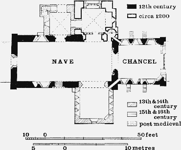
The Church of St. Mary the Virgin, Stoke sub Hamdon
By 1815 services were held at Stoke alternately morning and afternoon; (fn. 330) just over a decade later there were two services and two sermons each Sunday. (fn. 331) This was still the pattern in 1851: on Census Sunday there was a general congregation of 73 in the morning, with 82 Sunday-school children, and 216 in the afternoon with 104 children. (fn. 332) Holy Communion was celebrated 'more than three times a year' in 1840, and ten times by 1870. (fn. 333)
A church house was evidently under construction in 1544. (fn. 334) The property still retained its name until the late 18th century, when it became the Fleur de Lis inn. (fn. 335)
An iron mission church, dedicated to St. Nicholas, was built on a site on Ham Hill given by the duchy of Cornwall in 1905. It was closed in 1926 and services since then have been held at All Saints mission church, formerly the school. The former church is known as the Hamdon Hall. (fn. 336)
The parish church of ST. MARY THE VIRGIN, a mile east of the main village of West Stoke, was said in 1840 and 1859 to be dedicated to St. Denys. (fn. 337) In 1861 the dedication was said to be unknown. (fn. 338) From at least 1866 until about 1891 the dedication was to St. Andrew and thereafter to the Virgin. (fn. 339) The church consists of a chancel and nave, north and south transepts, the north forming the base of the tower, and a two-storeyed north porch. Vestries were added at the west end in 1916. (fn. 340) The nave and chancel are Norman and both retain pilaster buttresses at their angles. The chancel may originally have had an apsidal east end. The corbeltable below the chancel eaves survives. There are two small round-headed windows near the west end of the nave, that on the north side having its head cut from a single stone. Externally the head is carved with a man, a dragon, and interlacing ornament; it has been suggested that this may be Saxon work. (fn. 341) A blocked 12th-century window in the chancel is visible externally. Both north and south doorways of the nave, the latter now blocked, are of the 12th century and have flanking shafts with spiral, lozenge, and scale ornaments. On the tympanum of the north door is a relief carving of a tree of life carrying three birds, flanked on the right by a lamb and cross and an animal labelled LEO; a figure on the left is labelled SAGITARIUS [sic]. The fine 12th-century chancel arch is of three orders carved with billet, zig-zag, and lozenge ornament, the restored supporting shafts having scale and zigzag decoration.
The first addition to the Norman church was the base of the north tower which forms a stone-vaulted north transept, now used as the chapel of St. Denys. It was built c. 1200, the carved corbels from which the vaulting shafts spring being fine examples of Transitional work. A former stair projection on the east wall of the tower has been adapted as an altar recess. At the south-east angle of the transept is a combined piscina and hagioscope, the latter interrupted by a rood-loft stair. The upper part of the tower, which has twin lancets at the belfry stage, was built in the 13th century, and the parapet is a 15th-century addition.
The end of the 13th century saw the insertion of many new windows and probably the building of the south transept. Cusped lancets on both sides of the chancel near its west end are carried down as 'low side' windows. Further east two-light windows, one with later tracery, have cusped rear-arches supported on shafts. A large double piscina across the south-east angle of the chancel is of the same period. One of the two cusped lancets in the nave partly obscures the Norman window in the north wall. The south transept has four such lancets grouped together in each of its side walls, an angle piscina, and a hagioscope. A tomb recess in the south wall contains an effigy which may represent Reynold de Monkton (d. 1307), first provost of the secular college.
Later in the 14th century a window with reticulated tracery was inserted in the west wall of the nave. There is a window of similar type in the upper stage of the vaulted north porch. Externally, to the west of the porch, a canopy, the function of which is obscure, is built into the nave wall. In the 15th century the walls of the nave and south transept were raised in height and roofs of shallow pitch were constructed over them. Perpendicular windows were inserted at the east end of the chancel, above the south doorway, and in the north wall of the north transept.
The large circular font is Norman and has a moulded base and two boldly projecting bands of cable ornament, one combined with lozenges. There are fragments of 15th-century glass in the head of the east window; below is glass installed in 1949 depicting local industries. A 15th-century stone screen in the north transept arch may have been the former rood-screen. There is a canopied tomb of carved Ham stone bearing an effigy of Thomas Strode (d. 1595). The pulpit and communion rails date from the 17th century. In the churchyard is a 15th-century cross with a Crucifixion and a Madonna.
The church has six bells: (i) 1949, Taylor of Loughborough; (ii) 1787, G. Davis of Bridgwater; (iii) 1910, Taylor; (iv) 1949, Taylor; (v) 1530–70, Roger Semson of Ash Priors; (vi) 1688, Thomas Purdue of Closworth. (fn. 342) The plate includes a cup and cover inscribed with the date 1635. (fn. 343) The registers begin in 1558 but are incomplete. (fn. 344)
The free chapel of St. Nicholas, founded by 1287 and from 1304 the chapel of St. Nicholas's college, lay within the manor-house complex, on a site now occupied by the buildings of Castle farm. (fn. 345) It was evidently substantial, with more than one altar. (fn. 346) By the 16th century, although in some decay, it was still impressive; it had a nave large enough to hold seven tombs on the south-west side, five of them with recumbent effigies. There was also a wall tomb on the north side of the nave. The choir, separated from the nave by a screen, had a tomb on its north side; at the entrance to the choir was the brass over the tomb of Sir Matthew Gournay (d. 1406). The windows were filled with heraldic glass, and the floor decorated with heraldic tiles. (fn. 347) Fragments thought to have been part of the fabric are built into the walls of several houses in the village.
In the early 16th century mass was said there three times a week, though when the college was founded its members were to say fives masses daily as well as the canonical hours and the office for the dead. (fn. 348) Despite the pleas of the inhabitants that the chapel should be retained, the two bells and the lead from the roof were evidently sold, (fn. 349) and the building let with the parsonage estate. (fn. 350)
In 1535 there was a chapel on Ham Hill dedicated to the Holy Cross; oblations offered there belonged to Montacute priory as owner of Montacute rectory. (fn. 351) It probably stood near the Prince of Wales inn, where a piece of land was called Hanging Chapple in 1666, (fn. 352) and Ham Chapel in 1840. (fn. 353) Its connexion with Montacute may suggest an association with the fair on Ham Hill given by the count of Mortain to Montacute priory c. 1102. (fn. 354)
Nonconformity.
From 1689 onwards licences were issued for meetings in private houses, but usually the denomination was not specified. (fn. 355) By 1710, however, Henry Parsons, who in 1703 had been active in Montacute, was licensed to use his house in Stoke for meetings. Five years later he was described as the preacher in a Presbyterian meeting at Stoke, a group which was then receiving a grant from the Presbyterian Fund. (fn. 356) It is not clear whether the group survived, but in 1751 and 1753 licences for Presbyterian meetings were issued to Mary Clarke and Thomas Clothier respectively. (fn. 357) The house of Samuel Clark, 'lately used as a barn', was licensed, presumably for the same group, in 1773. (fn. 358) It may be identified with the Barn Chapel, possibly in High Street, founded before 1800 and used by Congregationalists by 1851. (fn. 359) In that year it was described as having 150 seats. Services were held on Sunday evenings and occasionally on weekdays. On Census Sunday 1851 the congregation numbered 106. (fn. 360) The present Congregational chapel in North Street was opened in 1866. The infant school was added and the chapel enlarged in 1875. (fn. 361)
Quakers appear to have used a room in the village by 1715. (fn. 362) There was no established meeting there, though in 1771 unsuccessful application was made to the quarterly meeting for a monthly meeting to be held there. (fn. 363) Stoke seems for a time to have been a member of a circular monthly meeting, in existence by 1786, though at that date it was 'in a declining state'. (fn. 364) By 1799 the meeting had evidently been abandoned and the meeting-house was not used for worship. (fn. 365)
The house of Unity Richards was licensed for use by Methodists in 1812, (fn. 366) but two years later it had been replaced by a Wesleyan chapel. (fn. 367) By 1851 two services were held each Sunday; in the afternoon the average attendance was 140, including 40 Sunday school children, and in the evening 170, including 30 children. The total congregations on Census Sunday 1851 were 110 in the afternoon and 140 in the evening. (fn. 368) The present chapel was erected in 1909, very near the original site.
A group of Bible Christians, founded in 1826, was using a chapel called Zion, erected in 1844 on the slopes of Ham Hill. (fn. 369) There were 123 sittings and on Census Sunday 1851 there were congregations of 43 in the morning, 45 in the afternoon, and 50 in the evening. (fn. 370) The chapel was closed c. 1882, (fn. 371) and was in 1968 a private house.
A group of Plymouth Brethren is thought to have succeeded the Congregationalists at the Barn Chapel. (fn. 372)
Education.
John Tachell, schoolmaster, was buried in Stoke in 1595, though whether he taught in the parish is not certain. (fn. 373) By 1819 the Sunday school had been established but was 'not properly attended to by the teachers in consequence of the smallness of their pay'. There was 'no parish in the neighbourhood where a good school' was 'more wanted'. (fn. 374) By 1825–6 the Sunday school catered for 61 boys and 62 girls. (fn. 375) By 1833 Stoke had nine schools: six small ones for infants, taking between them 48 boys and 72 girls; a day-school for 30 boys, supported by parents' contributions; and two Sunday schools, the larger, for 100 boys and 100 girls, attached to the church, the smaller, for 22 boys and 23 girls, to the Methodist chapel. (fn. 376) The church Sunday school was housed in a room built in 1831 on the site of the village pound, opposite the Fleur de Lis inn. (fn. 377) It is a small rectangular stone building with a four-bay front and central door, in the Gothic style, with a clock over the door. By 1847 the numbers in this school had fallen to 77 boys and 93 girls, under 16 teachers, all housed in the single room. (fn. 378)
It is not clear how long this school survived, but when the elementary day-school was opened in Castle Street in 1876 the children were said to be 'in wretched order . . . very ignorant . . . very backward'. (fn. 379) The school was administered by a committee, elected annually by subscribers, and was supported by school pence and a government grant. From the beginning an evening school was held in the same building. By 1877 there were 41 day and 74 evening pupils under three teachers. The pressure on accommodation became serious in the next twenty years: in 1895 there were 307 children in rooms for 223, but extension was evidently beyond the resources of the subscribers. A school board was therefore established and the school transferred to it in 1899. The premises were extended in 1900–1 to provide six rooms, with accommodation for 423. In 1903 there were 408 children on the books, with an average attendance of 313. (fn. 380) Evening classes, however, had been abandoned in 1899. (fn. 381) Attendances at the dayschool continued to rise; in 1908 there were 240 in the mixed department and 103 infants. (fn. 382) By 1938, however, the numbers had fallen to a total of 241. (fn. 383) The school, now known as Stoke Castle County Primary School, ceased to take senior pupils in 1940, and in 1969 there were 129 junior pupils on the books. (fn. 384)
In 1940 a new school was opened at the eastern end of the parish for senior pupils from Stoke and surrounding villages. It was at first known as Stoke Senior School and, from 1956, has been called Stanchester Secondary School. In 1969 there were 403 pupils on its registers. (fn. 385)
Charities for the Poor.
By will proved 1903 John Winter Walter gave an annual rent-charge of £5 for the benefit of the poor of the village. (fn. 386) The sum was distributed to forty widows in 1969. (fn. 387)