A History of the County of York East Riding: Volume 1, the City of Kingston Upon Hull. Originally published by Victoria County History, London, 1969.
This free content was digitised by double rekeying. All rights reserved.
'The city of Kingston upon Hull', in A History of the County of York East Riding: Volume 1, the City of Kingston Upon Hull, (London, 1969) pp. 1-10. British History Online https://www.british-history.ac.uk/vch/yorks/east/vol1/pp1-10 [accessed 26 April 2024]
In this section
THE CITY OF KINGSTON UPON HULL
Kingston upon hull stands on the north bank of the River Humber, at the mouth of its tributary the Hull, some twenty miles from the open sea; upstream, the Humber itself gives access to a wide-spreading system of rivers, striking deep into the heart of northern England. The importance of the Humber was aptly described by Sir John Fortescue in 1451: 'England has three rivers within himself coming out of the sea into the midst of the land, whereby the ships . . . of all manner nations, may convey and sail to in the greatest cities of the land, both ebb and flood with all manner merchandise. The first river is called Humber, that comes up to York and so forth up into the country . . .' . (fn. 1) This, then, was the foundation of Hull's rise to commercial eminence.
If its situation was so favourable, the town's site was in some respects less attractive: remote and low-lying, with a virtual absence of fresh water. There was only a small hamlet in the vicinity until the abbey of Meaux, seeking an outlet for its own wool and that of other Yorkshire wool-growers, planted the 'new town' of Wyke upon Hull there in the late 12th century. The River Hull provided a good haven, and in 1293 the town became Kingston upon Hull with its acquisition by Edward I, partly in order to serve as a base for his Scottish campaigns. Both before and after that time, however, it was commonly known simply as 'Hull'. During the 14th century Hull developed into the foremost port on the east coast and one of the leading ports in the kingdom. The export of wool and later of cloth and the import of wine were important branches of its trade, and it early established a flourishing commerce with the countries around the Baltic Sea. Periodically disrupted by war, this northern trade has nevertheless retained a dominant place in Hull's economy, alongside that across the North Sea to the Low Countries. For a time, in the 18th and 19th centuries, whaling added another dimension to the port's activities, and since about 1850 fishing in the North Sea and beyond has been prominent in the life of the town. The modern port has long ranked third in the country in terms of the volume of its trade, surpassed only by London and Liverpool. Its industrial development in the 19th century was, not unnaturally, closely linked to its overseas trade, and basically this has remained so to the present day: heavy industry is virtually absent.
Some of the River Humber's value to Hull disappeared with the coming of the railways, and with the growing importance of rail and road links between the port and its inland customers. Westwards improved communications have largely overcome the town's remoteness. Southwards, however, the Humber has continued to be a barrier to land traffic. A ferry was begun in the early years of the 14th century, but the Humber is two miles wide at Hull and the crossing has always been liable to interruption. Travellers have described its difficulties: Celia Fiennes in 1697 said that 'it rolls and tosses like the sea' and seemed 'more turbulent than the Thames at Gravesend'; Defoe in 1724 was 'near four hours tossed about' from Barton to Hull and thought it 'an ill favoured dangerous passage'; and in 1822 it was stated that, despite recent improvements to the ferry, the long route from London via York was 'generally preferred . . . by those who have an aversion for crossing the Humber'. (fn. 2) Proposals for a bridge over the Humber above Hull were first made in 1867; the matter was still under consideration in the 1960s.
In general the area treated in this volume is that within the modern city boundary. Its nucleus was the ancient borough which, with two adjacent liberties, was served by the chapelries of Holy Trinity and St. Mary's. Since the early 19th century boundary extensions have brought the whole or parts of eight ancient parishes into the borough. The parishes of Drypool, Sculcoates, and Marfleet have been completely absorbed, and in the case of Sutton the larger part of the parish, including the village itself, has been brought in. The histories of these four are therefore intended to be fully dealt with in this volume. The village centres of the other four ancient parishes—Hessle, Kirk Ella, (fn. 3) Swine, (fn. 4) and Cottingham—lie outside the modern boundary, and only relatively small parts of the first three have in any case been absorbed within it. The history of these places is therefore treated only in so far as it bears on the history of the city.
Boundaries
The king's borough created in 1299 is never topographically defined in the town's medieval charters. A comparison of rentals made in 1293, 1320, and 1347, however, suggests that from the first the borough comprised the area enclosed by the town defences when these were built in the second quarter of the 14th century. On the east and south it was bounded by the River Hull and the Humber. Later the docks which replaced the medieval walls in the 18th and 19th centuries formed the boundary of the borough. (fn. 5) The boundary remained unchanged until 1837, when the municipal borough was extended to become coextensive with the parliamentary borough created five years earlier. The approximate line of the ancient boundaries was represented in the 1960s by the filled-in dock known as Queen's Gardens and by Prince's and Humber Docks. It was in this area that burgage tenure was to be found, and to it applied all the enfranchisements of the charters. And it was this area which in the 19th century was commonly referred to as the 'Old Town'.
Ecclesiastically the borough was divided between two parishes, Hessle and North Ferriby; the churches of both those parishes are remote from the borough, and chapelries were early established, Holy Trinity taken from Hessle parish and St. Mary's from North Ferriby. There is no reason to suppose that the boundaries of these chapelries in the Middle Ages were greatly different from those mapped by the Ordnance Surveyors in 1853. (fn. 6) St. Mary's served that part of the town known in the Middle Ages as the Aton Fee and comprised the smaller northern portion of the borough. As early as 1454 it was said to include the liberty of Trippett, outside the walls. (fn. 7) Holy Trinity, too, was not wholly contained within the borough, but extended westwards beyond the walls to the boundary of its mother parish, Hessle. (fn. 8)

Parishes and Townships c.1850
This extramural portion of Holy Trinity was the manor, liberty, or precinct of Myton. (fn. 9) The former monastic grange of Myton formed part of the exchange with Meaux Abbey when Edward I created Kingston, and for most of the Middle Ages it was held, as a manor, by the Pole family. Myton did not possess burghal status, nor did its economic life merit such. But in 1440 the precinct of Myton and the borough together formed the newly-constituted county of Hull, and in 1552 the manor of Myton was granted to the corporation. The links between town and precinct were thus strong. Myton nevertheless remained outside the borough until 1837.
Trippett lay on the north side of the borough, between the Charterhouse and the town walls. It came into the hands of the corporation in 1611, but the corporation had leased it from the priors of the Charterhouse and their successors since 1519. Moreover, the town had rights in the area which the priors had acknowledged since about 1450. (fn. 10) Despite all this, Trippett does not appear to have become part of the borough, and in 1837, when it was brought into the new municipal borough, the boundary commissioners called it, like Myton, a liberty.
The charter of incorporation of 1440 granted the burgesses the right to elect thirteen aldermen, one of whom was to be mayor. Six wards, each with two aldermen assigned to them, were designated by 1442. After several early changes, their names were settled by 1481 as Humber, Austin, Trinity, Whitefriar, St. Mary, and North Wards; the last mentioned included Trippett. (fn. 11) The names remained unchanged until 1837, although once, in 1574, Whitefriar was called Beverley Gate Ward. (fn. 12) Their boundaries, too, seem to have changed little, if at all, (fn. 13) until 1837 when they were adjusted to suit the extended franchise. Latterly the precinct of Myton was also divided into wards, called North and South Myton; they were formed in 1824. (fn. 14) In 1810 the Hull and Myton Improvement Commissioners had been created to administer various public services in the Old Town, Trippett, and Myton. (fn. 15) The Sculcoates Commissioners had been similarly created in 1801 to act in the parish of Sculcoates. (fn. 16)
The charter of incorporation of 1440 withdrew the borough and its 'precinct' from the county of York and erected it into a county of its own. The 'precinct' is not specified in the charter, but when the county was enlarged in 1447 no mention was made of Myton in the detailed schedule. This fact, coupled with the close association of Myton with the town already mentioned, strongly suggests that the 'precinct' of 1440 was Myton. The enlargement of the county in 1447 was based on the fact that parts of the parishes of Hessle and North Ferriby were already in the town and on the belief that it was right for those parishes to be entirely within its jurisdiction. Tranby and Swanland, townships of the two parishes respectively, were also included. (fn. 17) A third parish, not described in the charter as such, was also granted: Kirk Ella, together with its townships of West Ella, Willerby, Wolfreton, and Anlaby. The site of Haltemprice Priory, (fn. 18) and Derringham Dike and its associated wells—the chief source of the town's water supply, were also brought within the county of Hull. The county's boundaries remained unchanged until 1835 when they were made coextensive with those of the borough.
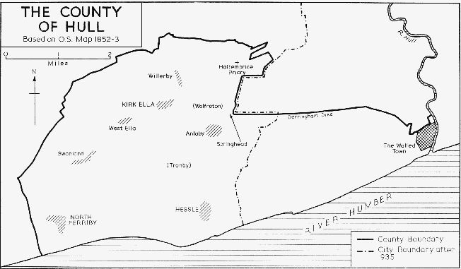
The county of Hull
The boundaries of Hull were not altered until 1832, when a new parliamentary borough was created. (fn. 19) On the boundary commissioners' recommendation, the parishes of Sculcoates and Drypool, the liberties of Myton and Trippett, a southern extension of Sutton parish, and the extra-parochial district of Garrison Side, on the east bank of the River Hull, were all placed within the parliamentary borough. Three years later the municipal borough was created under the terms of the Municipal Corporations Act and its boundaries were settled under the amending Act of 1836. (fn. 20) The municipal borough was for the time being made coextensive with the parliamentary borough, and the boundary commissioners of 1837 recommended no change to this situation. (fn. 21) The borough was thus enlarged from about 90 acres to 3,621 acres. (fn. 22)
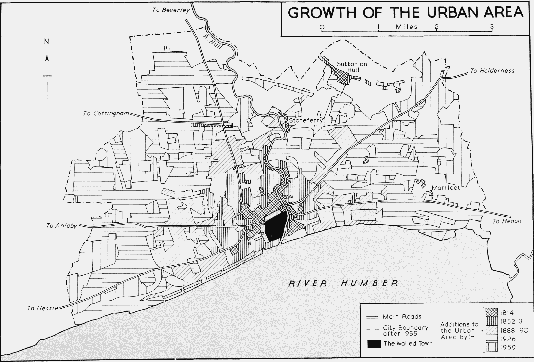
This new borough boundary took in all the suburban growths around the Old Town and left, so the 1832 commissioners thought, ample room for expansion. Until the 18th century there had been little suburban development outside the walls, but after about 1780 streets and houses appeared north and north-west of the town, notably alongside the newly built dock and near the new infirmary. (fn. 23) By the early 19th century the suburbs had gone further in these directions, and there were new built-up areas to the west of the town, especially around Great Passage Street, and around St. Mark's Square near the Humber bank. On the east side of the River Hull expansion was taking place around Drypool village and in the Groves district, and along several of the main roads leading out of the town there was a scatter of larger houses. (fn. 24) By the 1830s this pattern had been strengthened, with further infilling and extension of the built-up areas. (fn. 25)
More than thirty years passed before any change was made to the boundaries. In addition to much building within the boundary, new suburbs were developing beyond it in Dairycoates and Beetonville, to the west of Hull. In 1868 the parliamentary borough, but not the municipal, was extended to include these areas. (fn. 26) It was not until 1882 that the municipal borough was extended, but then the additions were considerable, amounting to 4,280 acres. On the west Hull gained the whole of the Newington district from the parishes of Kirk Ella and North Ferriby, surpassing the parliamentary gains of 1868. On the north Newland, part of Cottingham parish, was added. And on the north-east and east, Stoneferry, which was part of Sutton parish, and the whole of Marfleet parish were brought into the borough. (fn. 27) The parliamentary boundary was extended to coincide with the new municipal boundary in 1885, when Hull was given three parliamentary constituencies, East, Central, and West. (fn. 28) By this time the suburbs were already extending into the newly-added areas, for example in the St. John's Wood district north of Pearson Park, and new residential development was beginning in the avenues west of Pearson Park and at Newland Park further north. (fn. 29) In 1888 Hull became a county borough, (fn. 30) and in 1897 it was given the status of a city. (fn. 31)
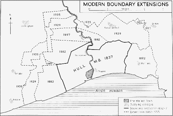
Modern boundary extensions
The next extension was made in 1897, when a large area to the north of Hull and a small one near Spring Bank were added to the municipal borough; both had been in Cottingham parish and together they comprised 1,301 acres. (fn. 32) The parliamentary boundary was not extended to include these additions until 1918, when the four constituencies of East, Central, North-West, and South-West were formed. (fn. 33) By 1919 the area of the borough on the west side of the River Hull was rapidly becoming built-up, though there was still much open ground on the western and northern margins. On the east side of the river, too, there had been much growth, some of it even outside the borough boundary along Holderness Road; but there was as yet little development in Marfleet. (fn. 34) During the next decade housing estates spread into much of the open ground on the west and north, and in the east the most notable development was around Preston Road, extending now into Marfleet. (fn. 35)
The borough was considerably extended in 1929, when 4,033 acres were added. Parts of Cottingham parish on the north and Hessle and Anlaby parishes on the west were brought in, and on the east part of Bilton parish and much of Sutton parish, including Sutton village. (fn. 36) Only six years later further extensions followed, amounting to 1,041 acres. Substantial additions were made from Cottingham, Willerby, and Kirk Ella parishes, and a small one from Anlaby parish, on the north and west. There was little extension on the east, but two very small additions were made from Bilton and Sutton parishes. (fn. 37) Housing rapidly spread into the new additions. (fn. 38) The Hull parliamentary divisions remained unchanged until 1948. Most of the county borough then fell into the East, Central, and North constituencies; but two of its wards went with the urban district of Haltemprice, established in 1935 and comprising the residential villages outside Hull on the west and north-west, to form the Haltemprice constituency. (fn. 39)
The growth of the city after the Second World War has left comparatively little open ground in the western half of the borough, and the largest remaining area—on the northern margin—was being used in the 1960s. In east Hull, too, the more extensive open areas were mostly built upon, and by the 1960s little was left in Marfleet and the village of Sutton was being submerged by new estates. Only one post-war boundary extension was made, however, and that a small one involving 60 acres from Bilton parish in 1955. (fn. 40) This brought the area of the borough to 14,493 acres. (fn. 41) The parliamentary boundaries were twice changed: in 1955, when the Haltemprice constituency was separated from Hull and the city's constituencies became East, West, and North, comprising the whole of the municipal borough; (fn. 42) and in 1956, when the new municipal extension of 1955 was brought within the Hull East constituency. (fn. 43)
The boundary extensions of the 1830s were accompanied by changes in the ward divisions of the borough. The six wards of the Old Town were converted into two, Lowgate and Market Place Wards. To the west of the town, North and South Myton Wards remained; to the north, West and East Sculcoates Wards were formed, the latter including the Trippett part of the medieval North Ward; and beyond the River Hull, Holderness Ward was created. (fn. 44) Following the boundary extensions of 1882 the wards became twelve in number, namely Newington, Coltman, Albert, Queen's, Botanic, Paragon, Park, Beverley, Central, Sutton, Drypool, and Alexandra Wards. Similarly four additional wards were formed in 1897, and the names became North Newington, South Newington, Coltman, Albert, Myton, Whitefriars, Botanic, Paragon, Newland, Park, West Central, East Central, Beverley, Southcoates, Drypool, and Alexandra Wards. Again, in 1930 five additional wards were created: Whitefriars dropped out, and the new names were St. Andrew's, Pickering, University, Stoneferry, Sutton, and Marfleet. No subsequent changes have been made to the 21 wards. (fn. 45)
Growth of the urban area