A History of the County of Oxford: Volume 12, Wootton Hundred (South) Including Woodstock. Originally published by Victoria County History, London, 1990.
This free content was digitised by double rekeying. All rights reserved.
'Kidlington: Introduction', in A History of the County of Oxford: Volume 12, Wootton Hundred (South) Including Woodstock, (London, 1990) pp. 179-183. British History Online https://www.british-history.ac.uk/vch/oxon/vol12/pp179-183 [accessed 27 April 2024]
Introduction
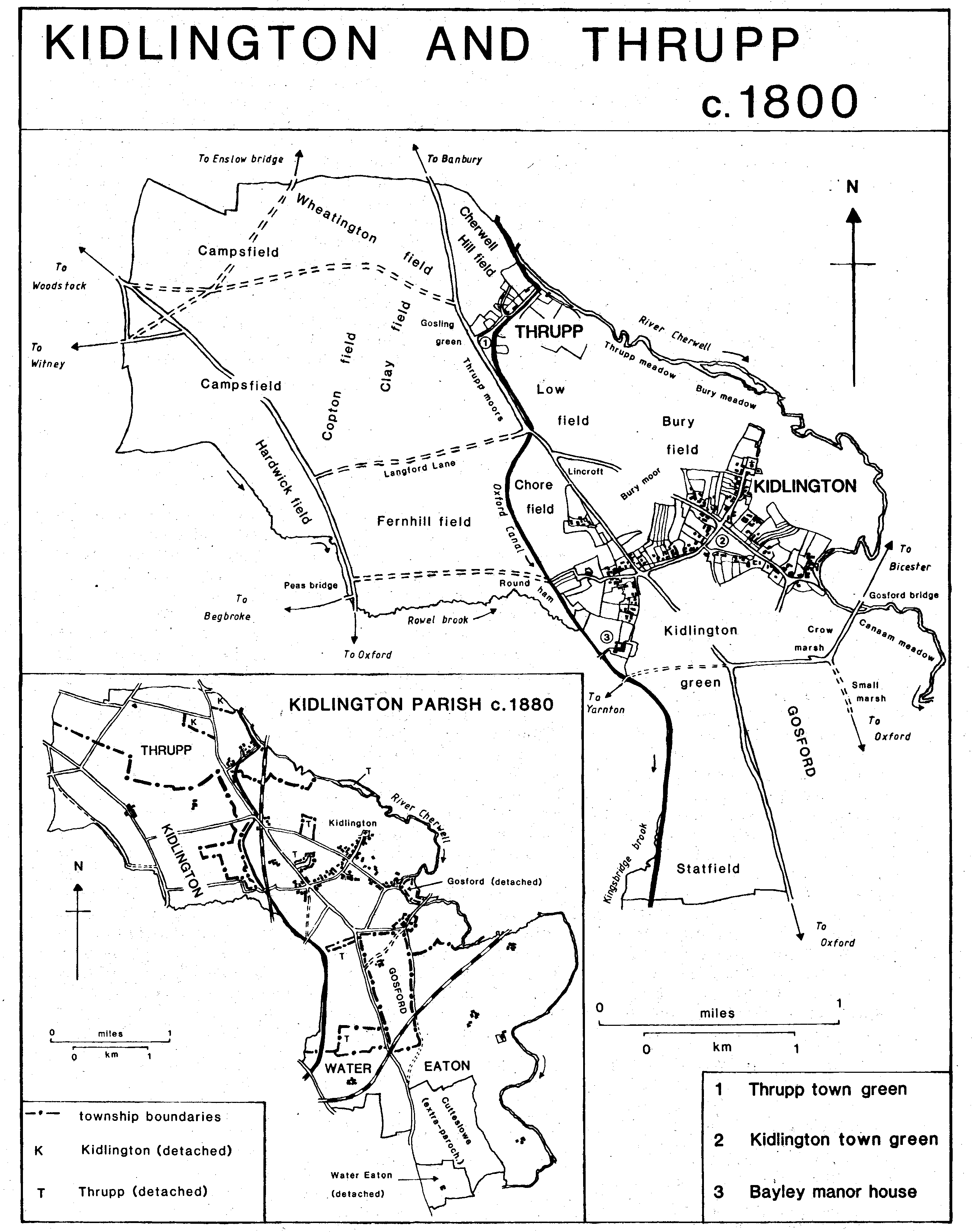
Kidlington parish, as it existed until 1929, covered 4,768 a. between Oxford and Woodstock and contained the townships of Kidlington, Thrupp, Gosford, and Water Eaton; the extra-parochial area of Cutteslowe was geographically within the parish but completely separate from it administratively. (fn. 30) Each of the townships became a separate civil parish in the 19th century. The area is dominated by Kidlington village which sprawls for nearly 2 miles along both sides of the main Oxford to Banbury road, ribbon development having been allowed in the mid 20th century as Kidlington became the largest of Oxford's dormitory villages. (fn. 31) The built-up area extends into the former Gosford township, but Thrupp was relatively unaffected by modern housing. At Water Eaton a slow process of desertion left only a few scattered houses.
The eastern boundary of the ancient parish followed the river Cherwell; the northern, recorded in the 11th century, (fn. 32) followed a stream, field boundaries, and the road to Hensington then known as the Wood way. The western boundary followed field boundaries, Rowel brook, Kingsbridge brook and, later, the Oxford canal, and the Oxford-Woodstock road; the southern boundary followed field boundaries, the Oxford-Banbury road, and streams. A detached part of Water Eaton, bounded partly by the Oxford-Banbury road, lay south and west of Cutteslowe. Until 1256 or later part of Cogges wood between Cogges and North Leigh belonged to Kidlington. (fn. 33) The ancient parish achieved its final form in the early 13th century when Water Eaton, itself composed of two or three originally separate units, was added to Kidlington, Thrupp, and Gosford. There was some doubt in 1225 whether Water Eaton was part of Kidlington parish, and although it was said to be so in 1228 and fairly regularly thereafter, as late as 1821 its inhabitants argued that they did not belong to Kidlington parish. (fn. 34)
Kidlington and Thrupp shared a field system, and until inclosure in 1818 there seems to have been no clearly defined boundary between them. Thereafter Kidlington township contained 2,194 a., including two detached areas in Thrupp, while Thrupp contained 813 a., including five detached areas in Kidlington. (fn. 35) Changes under the Divided Parishes Act of 1882 reduced Kidlington to 2,191 a., including a detached area of 15 a., and increased Thrupp to 816 a., including three detached areas of c. 63 a. in all. (fn. 36) The Oxfordshire Review Order of 1932 removed the detached areas and made other transfers between the various townships, with the result that Kidlington civil parish was increased to 2,305 a. and Thrupp was reduced to 666 a. (fn. 37) In 1948 Kidlington lost 144 a. to Begbroke parish, bringing its acreage to 2,161 a. (875 ha.). (fn. 38) In 1955 Thrupp was united with Shipton-on-Cherwell to form a new civil parish, Shipton-on-Cherwell and Thrupp, of 1,724 a. (698 ha.). (fn. 39)
Kidlington and Thrupp c.1800
Gosford seems originally to have been part of Kidlington township, but was separated when it was granted to the Hospitallers in 1142. (fn. 40) By the 16th century it was associated with Water Eaton for some administrative purposes. (fn. 41) In the 19th century the township comprised 260 a. and its boundaries followed the Banbury road on the west, the Bicester road on most of the north, Water Eaton Lane on most of the east, and field boundaries on the south; on the north-east the boundary skirted the inclosures of Gosford village. The township included a detached area of 18 a. between two streams of the Cherwell north of Gosford bridge. In 1932 the detached part of Gosford was transferred to Hampton Gay and Hampton Poyle, 1 a. was transferred to Kidlington, and the rest (241 a.) was merged in the new civil parish of Gosford and Water Eaton. (fn. 42)
The township of Water Eaton was formed in the Middle Ages by the union in the hands of Oseney abbey of an estate in Water Eaton, a 3 hide estate in Cutteslowe, and an estate at Fries, later Frieze farm. Bounds of the Water Eaton estate in 904 seem to describe an area east of the Banbury road. The boundary ran from the Cherwell at Wilsey northwards and then westwards along the boundary of the extra-parochial area of Cutteslowe to the spring or stream at Wulfwine's grove, probably near the modern St. Frideswide's Farm where it seems to have turned north and run across cultivated fields to the point later marked by the south-east corner of Gosford; thereafter it followed the later boundary back to the Cherwell. (fn. 43) In 864 the new owner of the estate was directed to pay 30s. to Eynsham church, suggesting an earlier tenurial or ecclesiastical dependance on Eynsham. (fn. 44)
The exact boundaries of Oseney abbey's Cutteslowe estate are not known, but the estate included the detached part of the 19th-century township of Water Eaton and the area west of the Banbury road later known as Jordan Hill. (fn. 45) Minor adjustments were probably made to the Water Eaton boundary c. 1388 when, after a protracted dispute, Oseney abbey gave St. Frideswide's priory 17a. in Cutteslowe and North Oxford in exchange for 6 a. in Water Eaton and 8 a. on the south boundary of Cutteslowe. (fn. 46) In 1588 Twisdelowe, an area of c. 40 a. on the Wolvercote boundary, was transferred from Cutteslowe to Water Eaton. (fn. 47)
Fries or Frize lies between the Banbury road and the Kingsbridge brook south of Kidlington, but the name, whose meaning is uncertain, seems originally to have been applied to an area which extended into Yarnton and perhaps Wolvercote. Fries was held by Oseney abbey from the earlier 12th century and by c. 1300 was part of the abbey's bailiwick of Water Eaton. (fn. 48) An estate there was said to be in Water Eaton in 1545 but in Kidlington and Wolvercote in 1574; in 1648 it comprised 200 a. in Kidlington and 20 a. in Yarnton. (fn. 49) In 1674-5 there was a dispute over whether the estate was in Water Eaton or Kidlington township, and although Fries was from the 17th century onwards usually treated as part of Water Eaton, in 1738 the vicar of Kidlington, presumably referring to Fries and Cutteslowe, reported that there were 'about four or five estates intermixed... which do not belong to this or any other parish that we know of.' (fn. 50)
Water Eaton in the 19th century comprised 1,501 a. of which 83 a. lay detached to the south. (fn. 51) In 1929, under the Oxford Extension Act of 1928, the detached part and a small area at Jordan Hill, a total of 101 a., were transferred to the city of Oxford, and a further 40 a. was transferred to the new civil parish of Cutteslowe. In 1932 the Oxfordshire Review Order united the rest of Water Eaton (1,360 a.) with most of Gosford (241 a.), the whole of the extraparochial area of Cutteslowe (682 a.), Pixey mead (51 a., formerly common to Yarnton and Begbroke), and 26 a. of Kidlington to form the new civil parish of Gosford and Water Eaton (2,360 a.). (fn. 52)
Much of the ancient parish of Kidlington lies between 60 m. and 65 m. above sea level; only in the north-west does the land rise to between 75 m. and 90 m. The southern part, south of Kidlington village, lies mainly on two wide bands of alluvium along the Cherwell and the Oxford canal; between them is a spine of Oxford clay rising to 74 m. at Frieze Farm and to 75 m. on a deposit of brickearth at Jordan Hill. North of Kidlington village the soil changes to cornbrash with large areas of gravel terrace. (fn. 53) Until inclosure in 1818 much of the clay and cornbrash was permanent grass, the arable being confined to the gravel and parts of the alluvium.
The Oxford-Banbury road, an ancient route turnpiked in 1755 and disturnpiked in 1875, runs from south to north through the middle of the parish; the Oxford-Woodstock road, turnpiked in 1719 and disturnpiked in 1878, forms part of the western boundary at Fries and cuts through the north-west corner. (fn. 54) A toll house on the Woodstock road at Campsfield survived as a private house in 1983; another nearby may have been demolished in 1878, as was a toll house on the Banbury road at Langford Lane. (fn. 55) A bridge or causeway on the Woodstock road at Fries, over the Kingsbridge brook and the adjoining marshy ground, was the responsibility of a bridge hermit in the late 12th century and of Oseney abbey in the 13th. An Oxford man left money to the bridge in 1271, (fn. 56) and in 1629 the bridge was a wooden one. (fn. 57) The brook itself was apparently named from the nearby canal bridge. (fn. 58)
A third main road, leading to Bicester and so to Cambridge, branches from the Banbury road to cross the Cherwell at Gosford bridge, which had replaced an earlier ford by c. 1250; (fn. 59) the bridge was rebuilt in the later 15th century, and was of stone by 1675. (fn. 60) Its repair was the responsibility of the inhabitants of Gosford and Hampton Poyle until it was taken over by the turnpike trustees in 1755. It became a county bridge on the expiry of the turnpike trust in 1872; it was repaired in 1880 and reconstructed in 1917 and 1938. (fn. 61) In the 17th century and perhaps earlier the Bicester road left the Banbury road at the two mile tree, apparently at Jordan Hill near the Cutteslowe boundary, and ran north-east across Water Eaton marsh, partly on the line of the modern Water Eaton Lane, to Gosford village and so to the bridge. (fn. 62) The road was turnpiked with the Banbury road in 1755, but in 1780 was replaced by a new turnpike which left the Banbury road c. 1½ mile farther north and ran east to join the old route, then known as Small Marsh Road, at Gosford. (fn. 63) By 1881 only 'faint traces' of the pitching of the earlier route across Water Eaton marsh remained, (fn. 64) and by 1983 even the footpath which had replaced the road had disappeared.
The road from Witney through Bladon to Enslow bridge crossed the north of the parish. It was turnpiked as far as Campsfield in 1751 and from Campsfield to Enslow bridge in 1768, and was disturnpiked in 1870. (fn. 65)
The main road pattern in the south was significantly altered by the construction in 1959 of the Gosford link road, from the Kidlington roundabout on the Banbury road to Gosford, and in 1960 of the Oxford north-western bypass, from the Peartree to the Kidlington roundabout. (fn. 66)
Langford Lane, which runs between the Banbury and Woodstock roads just north of Kidlington village, was called Wood way in the 17th century and the earlier 18th, (fn. 67) but it was not connected with the 11th-century Wood way on the northern boundary of the parish. (fn. 68) The modern name was first recorded in 1733, but there was a quarry called Langford pits near Thrupp in the later 17th century. (fn. 69) Until inclosure another road branched north-west from the Banbury road at Thrupp to cross the Enslow bridge road near the northern boundary of the parish. It was called Salt Street in 1589, (fn. 70) and may have been a branch of the salt way from Droitwich (Worcs.) to Prince's Risborough (Bucks.); in 1301 villeins owed salt works to the lord of Kidlington manor. (fn. 71) At inclosure in 1818 the road was replaced by the more northerly Campsfield Road. Footpaths to Islip and Hampton Poyle cross the Cherwell by footbridges. Sparsey bridge in Water Eaton, on the Islip path, was considered ancient in 1807, (fn. 72) but there is no evidence for its date.
The Oxford canal was constructed through the parish in 1788, using for much of its course the bed of the Rowel and Kingsbridge brooks. It was opened in 1790. At Thrupp, where the canal leaves the Cherwell, a canal basin was formed and a wharf built. Another wharf at Langford Lane, in existence by 1795, was rebuilt during the Second World War and used for the transport of materials for the nearby airfield. (fn. 73)
The Great Western's railway line from Oxford to Banbury was built through the parish and opened in 1850; a station, designed by I.K, Brunel, was built near the corner of Langford Lane and the Banbury road in 1852. At first called Woodstock Road, it was renamed Kidlington in 1890 and closed in 1964. (fn. 74) The building was still standing in 1983. The OxfordBletchley railway, a branch of the London and Birmingham Railway, was built through Water Eaton in 1850 and 1851. A station on the Banbury road at Water Eaton served as a temporary passenger terminus for Oxford in 1851 and remained as a goods depot until 1964. (fn. 75) In 1890 the Woodstock Railway Co. opened its branch line from Kidlington to Woodstock. The line, which ran beside the G.W.R. line from Kidlington station to Shipton-on-Cherwell, was closed in 1954 and the track lifted in 1958. (fn. 76)
Kidlington men attended the Woodstock and Bicester markets in the 16th century; in the 19th century and the early 20th, carriers' carts ran to Oxford several times a week. (fn. 77) Since 1923 Kidlington has been served by Oxford city buses. (fn. 78) There was a penny post station in Gosford in 1838 and a post office by 1847. By 1853 the post office had moved to Kidlington. (fn. 79)
Wells and streams provided water for Kidlington and its hamlets until the 20th century. Kindlington, Gosford, and Water Eaton were connected to the Oxford water supply in 1934. (fn. 80) Open drains, blamed for much disease in the early 19th century, were covered in 1843. (fn. 81) In 1931 the Thames Conservancy declared Kidlington's drains a nuisance, since they were polluting the Cherwell, but a new main drainage system was not built until after the Second World War. (fn. 82) Kidlington was included in the Oxford and District Gas Co.'s area of supply in 1924. (fn. 83)
Two round barrows survived near the Cutteslowe boundary in 1983, and two others in a field north of the Rowel brook were marked by ring ditches; (fn. 84) there may have been another at Anslowe cross, a name recorded in 1630, (fn. 85) in Kidlington village. In the Roman period there was a villa at Water Eaton whose tesselated pavement survived in 904, and another at Campsfield, known only from cropmarks. A farm or village associated with the Campsfield villa was occupied from the 1st to the 4th or 5th century, (fn. 86) and there was probably another farm north-west of Kidlington church, where pottery and coins were found in the 19th century and a stone-lined well survived in 1983. (fn. 87)