Historical Account of Newcastle-Upon-Tyne Including the Borough of Gateshead. Originally published by Mackenzie and Dent, Newcastle-upon-Tyne, 1827.
This free content was digitised by double rekeying. Public Domain.
Eneas Mackenzie, 'Fortifications and buildings: Town walls and gates', in Historical Account of Newcastle-Upon-Tyne Including the Borough of Gateshead(Newcastle-upon-Tyne, 1827), British History Online https://www.british-history.ac.uk/no-series/newcastle-historical-account/pp105-117 [accessed 30 April 2025].
Eneas Mackenzie, 'Fortifications and buildings: Town walls and gates', in Historical Account of Newcastle-Upon-Tyne Including the Borough of Gateshead(Newcastle-upon-Tyne, 1827), British History Online, accessed April 30, 2025, https://www.british-history.ac.uk/no-series/newcastle-historical-account/pp105-117.
Eneas Mackenzie. "Fortifications and buildings: Town walls and gates". Historical Account of Newcastle-Upon-Tyne Including the Borough of Gateshead. (Newcastle-upon-Tyne, 1827), British History Online. Web. 30 April 2025. https://www.british-history.ac.uk/no-series/newcastle-historical-account/pp105-117.
In this section
TOWN WALLS AND GATES.
ACCORDING to Harding, in his Chronicle, William Rufus not only built the New Castle upon Tyne, but also fortified the town by walls. (fn. 1) It is certain, however, that the town was walled in the reign of king John; for in the charter of the 17th of his reign (1216), the walls are expressly mentioned. Edward I. in 1280, granted the Black Friars a passage to their garden through the new wall, and which port appears to have been finished a year or two afterwards. The same king, in 1299, united Pampedon with Newcastle, which occasioned the building anew of the wall towards the east, through the close of the Carmelites, or Wall Knoll.
Edward III. in the first year of his reign (1327), granted the custom of things sold at Newcastle upon Tyne for seven years, to contribute towards the reparation of the walls of that town; and in 1334, this king, during his residence there, repaired the walls. The year following, Hugh de Merchinleigh, one of the bailiffs of that place, was removed from his office by the commonalty of the town, for having procured murage against them. (fn. 2)
The mayor and bailiffs of Newcastle upon Tyne having petitioned king Richard II. to have the defects in the walls repaired, an assignment was granted them, in the 10th of that reign, to take workmen for their reparation. In 1403, king Henry IV. granted to the mayor of Newcastle all fines and forfeitures, for the reparation of the walls and bridge of that town: and in 1527, mention occurs of an annuity of £20, granted by king Henry VIII. for the support of the walls and bridge of Newcastle upon Tyne. During the remarkable siege of that town by the Scots in 1644, the walls were so much damaged, that parliament granted £2564 for repairing them. (fn. 3) In 1667, the common council ordered the walls, gates, and draw-bridges of the town, to be immediately repaired. The town was again put in a posture of defence during the rebellion in 1745, and several houses and other obstructions near the walls were pulled down. Since that period, the utility of such warlike barriers is completely superseded. Great part have been demolished, and many of the fragments that remain are much dilapidated.
These famed walls were twelve feet high, eight feet thick, and strengthened by a wide fosse. The gates in them were all embattled, and the intervening lines commanded by strong towers, "between each of which," says Bourne, "there were for the most part two watch towers made square with effigies of men cut in stone upon the top of them, as though they were watching, and they are called garret, which had square holes over the walls to through stones down."
According to Hutton's plan, the circumference of the walls from the Close-gate to Sandgate is 2740 yards. By an admeasurement made in 1745, by Mr. Thomas Aubone, the whole circuit of the walls, including the space next the river between Sandgate and the Close-gate, is 3759 yards 1 foot; or 2 miles, 239 yards, and 1 foot. Bourne makes the whole circumference only 2 miles and 176 yards, but does not state his authority. (fn. 4)
After the completing of the walls, the town was divided into twenty-four wards, according to the number of the gates and towers in them, which were, in times of hostility, defended by the particular wards appropriated to them. (fn. 5) The wards were, 1. Close Gate.—2. White Friar Tower.—3. Denton or Nevil Tower.—4. West Spital Tower.—5. Stank Tower.—6. Gunner Tower.—7. Pink Tower.—8. West Gate.— 9. Durham Tower.—10. Herber Tower.—11. Morden Tower.—12. Ever Tower.— 13. Andrew Tower.—14. New Gate.—15. Bartram Monbowcher Tower.—16. Ficket Tower.—17. Pilgrim-street Gate.—18. Carlell Tower.—19. Plummer Tower.—20. Austin Tower.—21. Corner Tower.—22. Pandon Gate.—23. Wallknoll Tower.—24. Habkyn Tower. Another account makes but 23, as Wallknoll and Habkyn Towers are said to be "nowe but a warde." In the modern distribution of wards, "Sand Gate and Castle Garth" occur.
The Close Gate (fn. 6) evidently derived its name from the street called the Close. After the fall of the Tyne Bridge in 1771, its tower was converted into a temporary prison. In 1797, it was taken down; the gateway being narrow, awkward, and dangerous. There was a turret, or tower, 52 yards to the south of this gate, and adjoining to the river. It was once the meeting-house of the House Carpenters' Company, and afterwards of the Sailmakers. From the Close Gate, there were an hundred and forty steps, on the top of the wall, as it mounts a very steep hill to White Friar Tower. (fn. 7)
White Friar Tower (fn. 8) was so called from the adjoining house of the Carmelites, or White Friars. A breach was made in the wall here, and a mine sprung, when the town was stormed by the Scots. The fraternity of Masons had their hall in the upper apartment of the tower. In the lower one was the meeting-house of the Bricklayers and Metters. In 1776, Isaac Cookson, Esq. obtained a lease of this tower, which he converted into an ice-house. It is still in the possession of this gentleman.
Denton or Nevil Tower (fn. 9) is supposed to derive the first of these appellations from John de Denton, who was a bailiff of Newcastle in 1339, or from some of his family; as it undoubtedly does the second from the Nevil family, whose town-house, called Westmoreland Place, stood near, and is said to have communicated with it by a subterraneous passage. Bourne supposes that the postern below the tower was made for the convenience of the White Friars, that they might walk to the Forth and neighbouring fields. He also imagines this to have been the gate through which, in the reign of Edward III. three hundred valiant men sallied by night, and, rushing into the camp of the Scots, routed the whole army, and took the Earl of Murray prisoner in his tent. This postern was remarkably strong, having gates of oak, iron doors, and a heavy portcullis. The arms of Clavering and Shaftoe were cut in stone over the gateway; and these names occur as mayor and sheriff in 1607, 1629, and 1663. The tower is at present the hall of the company of Wallers, Bricklayers, and Plaisterers; but the gate was pulled down in 1805. (fn. 10) The old wall from the White Friar Tower to this place, though mostly hid by buildings, is in a good state of preservation.
West Spital Tower (fn. 11) derived its name from St. Mary's hospital, otherwise called "West Spital," which stands very near it, and was probably built by the master and brethren of that establishment for their security and defence. It is certain that they obtained a patent, in 1290, for making hereabouts a postern gate in the town-wall. This now forms part of a genteel dwelling-house, and its circular walls may still be seen in a good state of preservation.
Stank Tower. (fn. 12) —The upper part of this tower is demolished. There is a passage through it to a dwelling-house, and another into a garden. The adjoining walls are greatly dilapidated.
Gunner Tower, or rather Gunnerton Tower, (fn. 13) is said to have been built by the ancient family of Swinburn, who had a house behind it. (fn. 14) In 1821, it was converted into a hall for the incorporated company of Slaters and Tylers; on which occasion the workmen found a large quantity of shillings and sixpences, of the coinage of Edward I. The tower has been very neatly repaired, and the hall is light and spacious.
Between this tower and the next, a postern conducting to the Forth was made in 1705, as appeared by an inscription over the gate-way. When it was made, a Mr. Whitfield gave to the public, out of his private property, the lane which leads to it from Westgate Street. This gateway was taken down in 1811; and the whole wall between it and Gunnerton Tower has lately been removed.
Pink Tower. (fn. 15) —The basement story of this tower is still in a state of good repair. It is used for the convenience of the adjoining inhabitants.
THE West Gate (fn. 16) consisted of four wards, and was secured by massive gates of oak and iron doors. Leland calls it "a mightye strong thinge." It was once a prison for unruly apprentices; and, during the civil war, contained seventeen prisoners, who clandestinely obtained ropes, and, during a violent stormy night, let themselves down by the privy and escaped. (fn. 17) After this, it became the hall of the incorporated company of House Carpenters. A foot-way was opened out on the north side of this gloomy gateway in 1782; but, in 1811, the whole was pulled down, and also part of the wall on the south side. According to tradition, this strong gate was built by the wealthy and munificent Roger de Thornton. (fn. 18)
Durham Tower (fn. 19) is now in a very ruinous state.
Herber Tower (fn. 20) is the meeting-house of the Felt-makers, Curriers, and Armourers, at whose expense it was repaired in 1620. It is called, in the books of this society, "Harbot Tower."
Mordon Tower (fn. 21) is the hall of the Glaziers, Plumbers, Pewterers, and Painters, who repaired it in 1700. A gilded ball, suspended from the centre of this meetingroom, probably had been shot from the cannon of the Scottish army during the great siege of the town in 1644, and, having lodged in the wall, was discovered on the alteration of the tower. The outside of the adjoining wall bears marks of this memorable siege. The inside was, in late years, much injured and disfigured by people picking out the freestone to bruise into sand; but it is now put into a good state of repair. Between Mordon and Herber Tower there has been anciently a postern in the wall, belonging to the monastry of the Black Friars.
Ever Tower (fn. 22) was built by some of the ancient family of Eure or Ever, lords of Kirkley near the river Blyth, and barons of Witton in the county of Durham. It is the meeting-house of the Paviors, Colliers, and Carriagemen, by which society it was rebuilt in 1707, and thoroughly repaired and beautified in 1771.
Andrew Tower (fn. 23) evidently acquired its name from its vicinity to St. Andrew's church. At the west end of this tower, a wide opening was made in the wall in 1810, and called Heron Street.
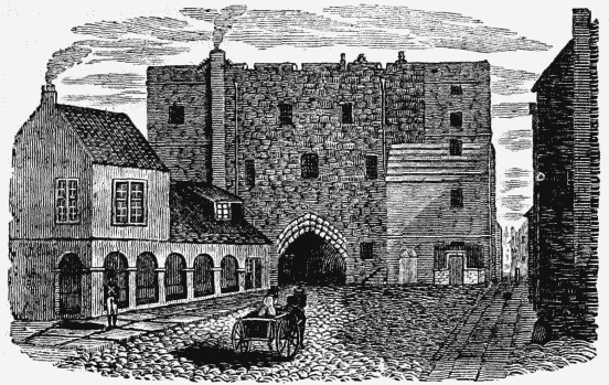
New Gate. (fn. 24) —From the name of this noble gate, we may infer that it has been erected on the scite of an older one, which appears to have been called "Berwick Gate," and through which the bishop of Durham marched to join the English army that fought the Scots at Otterburn in 1388. This gate is, however, mentioned in 1390, with its present appellation. (fn. 25) When Newcastle, in 1399, was made a county of itself, and took custody of its own prisoners, it became the common gaol of the town. Before this period, they were probably confined in the Castle. The south front was evidently the most ancient part of the structure, and exhibited the same style of architecture, and the same aspect of strength and defiance, as the inner ward of Alnwick Castle. Bourne says, it "is not only the strongest, but also the most antient, of all the other gates. It is of the same masonry and way of building with that part of the wall which leads to Westgate westward, as far as Ever Tower, which is visibly the oldest part of the wall." The wings to this front were only recent additions; the one being added in 1702, and the other in 1706. The north front, or gate, was intended as an outwork to the defences of the main gate, and had, like similar structures, a gallery on each side, from which furious and imprudent assailants who had passed the first entrance might be attacked. On this front were three ancient shields of arms:—St. George's cross; arms of England, with the fleurs de lis semée; and those of Newcastle upon Tyne. (fn. 26) Above the entrance was a statue, resembling king James I. It was placed under an arch, had a crown and robes, held a sceptre in the right hand, and a globe in the left. It is now in the Castle. In 1765, a foot-way was opened through the town's wall, on the east side of the gate, for the convenience of the public, and which was considerably widened in 1811.
At the spring assizes in 1820, Newgate gaol was presented by the grand jury of the town and county, "as being out of repair, and inconvenient, insufficient, and insecure." An act was therefore obtained for building a new gaol; and the felons and debtors were successively removed, the former to the new prisons in the county courts, and the latter to the Castle. In June, 1823, workmen began to pull down the east wing of Newgate, which was followed by the removal of the west wing; and the north gate being also demolished, the most ancient part of the building became isolated. A vigorous, but unsuccessful effort was now made by the lovers of antiquity, to save this venerable monument of ancient times from destruction; but, in the following September, it also fell a sacrifice to the improving spirit of the age. (fn. 27) Part of the walls were blasted with gunpowder; whilst other parts, on removing the facing stones, appeared like heaps of rubbish. The portcullis, which was found in a very perfect state, is now at Blagdon. During the demolition of this structure, several large cannon-balls were found, deep sunk in the wall. The above wood cut, by Nicholson, represents the south front of Newgate, with the guard-house adjoining its west wing, and the foot-way into Percy Street on the east side.
Bertram Mombowcher Tower (fn. 28) plainly derives its name from the Bertram Mombowcher who was high sheriff of Northumberland in the reigns of king Edward III, and king Richard II. and who possessed property in Newcastle upon Tyne.
Fickett Tower (fn. 29) stood nearly opposite to the chapel of the Grey Friars. The Joiners' Hall stands on the south side of the scite that it occupied.
PILGRIM STREET GATE. (fn. 30)
—This gate was a remarkably strong, clumsy, and gloomy building, and, after the defence of the walls became unnecessary, a very great nuisance; the arch being so low as both to obstruct the passage of waggons, and the free circulation of the air into the town. In 1716, it was repaired and beautified by the Joiners' Company, whose hall was above the gate; and in 1771, convenient foot-passages were opened out on each side: but in 1802, the whole fabric was demolished. The workmen, on this occasion, found a cannon-ball in the wall, about a yard below the battlement of the old gate, which weighed more than 22 lb. Allowing for waste, this had probably been a 24 pounder, fired during the siege of the town in 1644, when this gate was so gallantly defended. The whole of the town wall between Newgate and Pilgrim Street has just been pulled down, and the stones employed in forming the common sewer for Blackett Street.
Carlel Tower, (fn. 31) or the Weavers' Tower, derives its appellation from the family who gave its name also to the Carlel or Carliol Croft. It was fitted up by the Weavers' Company for a meeting-house in 1682; and in 1821, it was again repaired, enlarged, and beautified, though in a style of architecture not in accordance with the date of the building. The hall is now extremely commodious; and a turret, containing the stair-case, has been annexed to the tower, on which a flag is hoisted on days of rejoicing. The whole of the improvements are creditable to the public spirit of this ancient society, and ornamental to the new street, of which it now forms a part. The corporation assisted in effecting these alterations. The workmen employed in forming two windows on the north side of the hall, found, in December, 1824, a cannon-ball, weighing above 23 lb. It had penetrated about two feet into the wall where the north-west window is now made, and was probably shot in effecting the breach near to this tower, so nobly defended when the town was stormed in 1644. (See page 31.)
Between this tower and Pilgrim Street Gate were three small turrets, one of which was called the Waits' Tower, being formerly the meeting-house of a band of musicians kept by the town. At another, which was also once used as a meeting-house, was a curious old arch, compared by Brand to that above Pandon Gate. This part of the wall was pulled down in 1811, in forming one of the branches of the new Shields road.
Carliol Croft Tower, otherwise Plummer Tower. (fn. 32) —This was also called the Cutlers' Tower, having once been the hall of that company, who are now extinct. In 1742, it was granted to the fraternity of Masons, by whom it was repaired and fronted in a handsome manner. It will soon be hid amidst a crowd of buildings.
Austin Tower (fn. 33) has evidently derived its name from its vicinity to the house of Austin Friars. It was successively the hall of the Millers and Coopers, and afterwards of the Ropers, who repaired it in 1698. The lower apartment is converted into a stable, and the hall is in a state of dilapidation; but the company to whom it belongs usually assemble at a tavern.
Corner Tower (fn. 34) is probably so called from being in an angle of the wall. It is mentioned in the common council books, June 9, 1688, by the name of "Corn-Hill Tower;" an evident corruption of Corner Tower. It stood in a commanding situation, but is now in ruins, and, with the fragments of the adjoining wall, will, no doubt, soon be demolished.
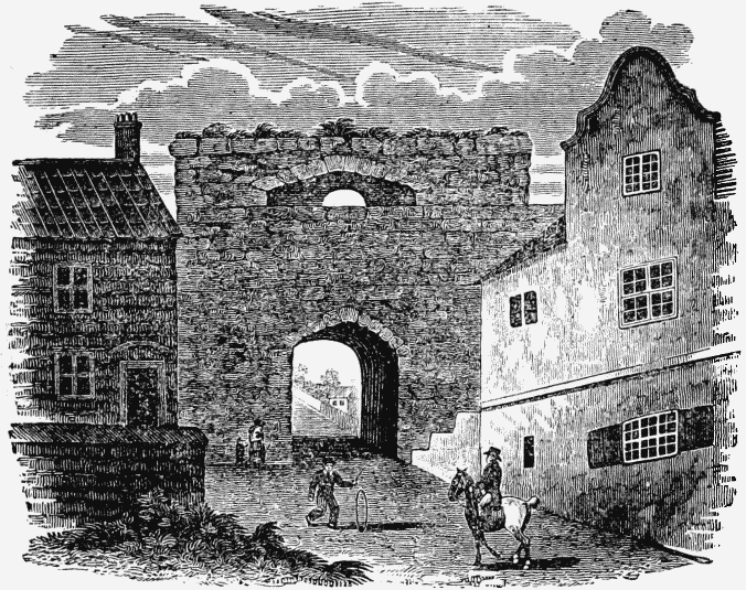
Pandon Gate was a very ancient structure; for, "As old as Pandon-Yate," is a proverb of great antiquity. Grey, who wrote his Chorography in 1649, speaking of the towers of the Roman Wall, says, "One of these towers remaineth whole in the towne-wall of Newcastle, in Pampeden, (fn. 35) older than the rest of the towers, and after another fashion standing out of the wall." Bourne also calls it "a Roman turret;" but Brand thinks this is an error, as he conceived the Roman Wall passed it at a considerable distance. (fn. 36) This gate had folding iron gates, but no portcullis, and was ascended to the top by a flight of stone stairs, two yards wide. The tower was anciently the hall of the Barber Chirurgeons; but the west wall being destroyed during the civil wars, this society, in 1648, obtained a scite in the Manors whereon to build a meeting-house. This interesting remain of antiquity was totally demolished in 1795; but fortunately a drawing of its form was preserved, which has been exactly copied in the above wood engraving.
Wall Knoll Tower, (fn. 37) now called Carpenters' Tower, because the company of Carpenters or Shipwrights meet in it, "was," says Bourne, "one of the towers of the Old Romans. This company, in the year 1716, built upon the under part of it a very grand and stately square tower, adorned at the top corners with 4 fair turrets, built in the form of a lanthorn." He adds, on the authority of a MS. intitled, "Lib. de Reb. Novocastri," that, "before the taking down of the top of the old tower, it was much of the same size, model, and stone, with the tower of Routchester, in Northumberland, which was certainly one of the towers belonging to the Picts-Wall." The ancient postern gate in this tower was the usual passage of those divisions of the garrison that so frequently sallied out, and attacked the besieging army during the civil wars. It is probably from this circumstance that it is called the Sally-Port Gate.
Sand Gate has evidently had its name from being built upon the sand on the side of the river. It was taken down in 1798, having been found extremely inconvenient and dangerous to foot-passengers when carriages were passing. The wall between this gate and the Glassite chapel was removed in 1810–11. This part of the fortifications was exceedingly strong and lofty, and seemed to have been erected, or rebuilt, at a later period than any of the other parts. At the foundation of the wall, where Foster Street is now formed, a deep narrow hole was discovered, to the sides of which some rotten wood adhered, and which, it is conjectured, was the remains of a wooden mooring-post for small craft. The banks behind have been formed of ballast. The workmen also discovered two leaves of the Bible carefully inserted between the stones, and which may have been hid by some person when it was dangerous to have possession of this book.
From Sand Gate the town wall extended along the Quayside to the Tyne bridge. The foundation of this part of the wall was discovered in 1823, twelve feet below the surface, and under the scite of the Maison de Dieu. "On the top of this wall," says Bourne, "was a walk, and at the bottom of it a great many gates, called Water Gates. These, in the reign of king James I. Anno 1616, were ordered to be locked up every night, except one or two to stand open for the masters and seamen to go to and fro to their ships. This was done to prevent servants casting ashes and other rubbish into the river; and those two gates were watched all night long." A passage leading from the Sandhill to the High Crane still retains the name of the Water Gate; but in the common council books, 1649, it is, says Brand, called "the Windowes Gate." Leland, who visited Newcastle in the time of Henry VIII. tells us there were "a strong wardyd gate at Gateshed, a strong ward and towre on Tynebridge, and a gate at the Bridge-end." The wall extending from the Sandhill to Sand Gate being found "no longer of any use for defence, but a great obstruction to carriages, and hinderance to the dispatch of business," the corporation petitioned for leave to remove it at their own expenses, and to make use of the stones for building a church. On November 17, 1762, an order of the privy council was signed, in compliance with this request; and on January 10, 1763, the workmen began to pull down the wall and gates upon the Quay. The fortified line from the Bridge-end to Close Gate is described in Speed's map of Northumberland, which contains a plan of Newcastle of the date of 1610.
THE FOSSE.
The fosse or ditch that anciently surrounded the walls is now mostly filled up, and levelled with the adjoining ground. The space, however, which it occupied is still called the "King's Dikes." It appears to have been uniformly twenty-two yards in breadth, and is claimed by the corporation, to whom every waste within their jurisdiction devolves, by the authority of their charter. A narrow passage, which still remains open in many places, has also conducted round the town, on the inside of the wall, and was probably used for the purpose of conveying ammunition, &c. during a siege. (fn. 38)
The union of the two gallant and long rival nations, the firm establishment of the present royal house, and the irresistible prowess of our large navy, have rendered these fortifications unnecessary, which were so honourably raised, and so bravely maintained by the old burgesses of Newcastle. The magistracy seem therefore determined to demolish them, so far as they interfere with the health and convenience of the inhabitants, who, in case of an hostile invasion, would, with the spirit of freemen, form a barrier of bayonets around their property, even more impregnable than the stone walls of their forefathers.