Ancient and Historical Monuments in the County of Gloucester Iron Age and Romano-British Monuments in the Gloucestershire Cotswolds. Originally published by Her Majesty's Stationery Office, London, 1976.
This free content was digitised by double rekeying. All rights reserved.
'Southam', in Ancient and Historical Monuments in the County of Gloucester Iron Age and Romano-British Monuments in the Gloucestershire Cotswolds, (London, 1976) pp. 106-109. British History Online https://www.british-history.ac.uk/rchme/ancient-glos/pp106-109 [accessed 20 April 2024]
SOUTHAM
(14 miles N. of Cirencester)
Two slight banked circles some 50 ft. in diameter occur on Cleeve Hill. One of them is on the cliff edge inside the hill-fort (1) and the other is 50 yds. outside, to the north. They are shown on large scale O.S. maps and are clearly seen on Plate 40. They are probably of recent date, possibly tree-rings. (fn. 1)
Two pots with Roman coins of gold and silver are said to have been found at Cleeve, in or before 1811. (fn. 2) Bronze miniature models of a dagger and a socketed ploughshare from Cleeve Hill are in Cheltenham Museum.
(1) Hill-fort (SO 985255), Cleeve Cloud, unexcavated, bivallate with intermediate berm, now encloses about 3 acres of ground sloping gently W. to the partly quarried cliff edge of Inferior Oolite (Plate 40). No entrance survives. The banks and ditches have been disturbed in places by quarrying, and on the N. the outer defences have been cut through to make a golfcourse. A rectangular platform abutting the inner bank, 100 ft. from its N. end, is probably recent.
Each bank and each ditch is about 30 ft. across, the banks standing 8½ ft. to 11 ft. above the ditches. The berm which separates the inner ditch from the outer bank is 30 ft. wide in a disturbed area S. of a golfgreen; elsewhere it is half this width or less.

Monuments in Southam and Gotherington.
C.U.A.P., VAP RC8—N 97–8; OAP AIK 16.
Arch, XIX (1821), 171. PCNFC, VI (1876), 209, No. 9. Witts (1883), 13, No. 27. Burrow (1924), 61–3.
Note: The situation of monuments (2)–(6) can be seen in Plate 40.
(2) Iron Age Settlement (SO 986269), near The Stables, S.E. of Cleeve Lodge, was identified c. 1903 in a quarry. Shallow pits and an assemblage of finds said to be similar to those described below (monument (3)) came to light. Pottery included stamped ware.
Uphill of the quarry on a moderate W.-facing slope the remains of undated ditched enclosures, roughly rectangular, cover some 1½ acres. The ditches are up to 20 ft. across, below banks 4 ft. high.
C.U.A.P., VAP RC8—N, 94–5. R.A.F., VAP V58/RAF/ 8390: 0033.
PCNFC, XV (1904), 55. Bagendon (1961), 23. TBGAS, 58 (1936), 162.
(3) Settlement (SO 98272670), King's Beeches, ¼ mile S.W. of (2), Iron Age and perhaps Romano-British, was noted in 1903 during quarrying into a platform, most of which still survives, some 90 yds. long by about 20 yds. wide. It is in a relatively exposed position near a spring. Of seven beech-trees planted about 1902, three have died. Some 5 ft. depth of soil and rubble, perhaps the result of quarrying, overlie soil containing occupation debris; below was the natural gravel into which a number of pits had been dug, some of them probably post-holes. Finds included pottery, most of it poorly fired, wattle-marked daub, bones including human and of fowls, sawn red deer antler, worked stones of various kinds and, still in the old soil, numbers of stone slabs. Three late 3rd-century Roman coins were found among these stones at a level above the old ground surface.
PCNFC, XV (1904), 49–67.
(4) The Ring (SO 985266), undated, but possibly of the Iron Age, encloses about ½ acre on a moderate westfacing slope (Plate 41). The S.W. entrance is original. Area (a) could be a hut-platform. The level area (g) in its present form is part of a golf-course.
R.A.F., VAP V58/RAF/8390: 0334–5.
(5) Platformed Ringwork, immediately N.E. of (4), undated, possibly Iron Age, has a flat interior about 30 ft. across, perhaps for a hut. The entrance, aligned as in (4), is original.
(6) Dyke (extending E. from SO 98352630), undated, probably of the Iron Age, extends for over ⅓ mile across the ridge of Cleeve Cloud, from a quarried area on the W. brow to a point scarcely 20 ft. above the floor of a narrow re-entrant which penetrates the E. side of the ridge. Its course changes over short stretches towards the E. end.
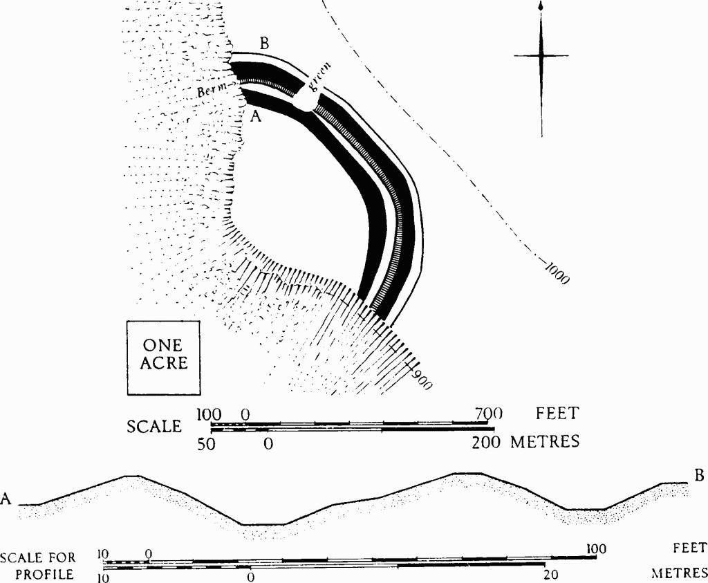
Southam. (1) Hill-fort, Cleeve Cloud. Plan and profile.

Southam. (4) The Ring. (5) Platformed Ringwork. Plan and profiles.

Southam. (6) Dyke. Profiles.
Much of the dyke comprises a bank some 15 ft. wide, standing up to 3 ft. high above a ditch of similar width. In general the bank is on the S. or downhill side, but at the W. end, where the N.—S. slope is insignificant and the dyke crosses a W.-falling slope of up to 18½°, it is on the north. A hollow-way about 7 ft. deep (h on the general map, p. 107) cuts the dyke at SO 98772634. To E. of h and for a short distance to W. the dyke appears as a terrace with a slightly hollowed surface; further W. it is more pronounced. No original entrance is seen.
R.A.F., VAP V58/RAF/8390: 0335.