Ancient and Historical Monuments in the County of Gloucester Iron Age and Romano-British Monuments in the Gloucestershire Cotswolds. Originally published by Her Majesty's Stationery Office, London, 1976.
This free content was digitised by double rekeying. All rights reserved.
'Stanton', in Ancient and Historical Monuments in the County of Gloucester Iron Age and Romano-British Monuments in the Gloucestershire Cotswolds(London, 1976), British History Online https://www.british-history.ac.uk/rchme/ancient-glos/pp109-110 [accessed 30 April 2025].
'Stanton', in Ancient and Historical Monuments in the County of Gloucester Iron Age and Romano-British Monuments in the Gloucestershire Cotswolds(London, 1976), British History Online, accessed April 30, 2025, https://www.british-history.ac.uk/rchme/ancient-glos/pp109-110.
"Stanton". Ancient and Historical Monuments in the County of Gloucester Iron Age and Romano-British Monuments in the Gloucestershire Cotswolds. (London, 1976), British History Online. Web. 30 April 2025. https://www.british-history.ac.uk/rchme/ancient-glos/pp109-110.
STANTON
(20 miles N. of Cirencester)
The hill-fort on Shenberrow Hill (1) is the smallest in the area covered by this volume of the Inventory.

Monuments in Stanton.
(1) Hill-fort (SP 080334), on Shenberrow Hill, bivallate, excavated, encloses 2½ acres on a sloping spur of the Cotswold escarpment, 1 mile E.S.E. of the village (Plate 39).
The inner defences consist of a rampart 30 ft. wide and 5 ft. high, and a ditch 25 ft. wide and 4 ft. deep, partly obscured by farm buildings on the S.E.; to N. and S. both features terminate at the scarp edge. A disturbed bank 20 ft. wide and 3 ft. high, set parallel with the scarp edge and linking the rampart ends, has no visible ditch. The entrance is through a gap in the rampart, 125 ft. E. of its S. end.
The outer defences are undisturbed on the N., where the rampart is 25 ft. wide and 2 ft. high and the ditch is 25 ft. wide and 3 ft. deep; elsewhere the rampart has been levelled and the ditch is traceable only as a cropmark; farm buildings obscure its S. end.
A narrow bank defines the S. and E. sides of an enclosure, 60 ft. by 50 ft., in the N. corner of the interior. Excavation in 1935 showed that the inner rampart has a drystone revetment on its inner face at the point marked A on the plan, and the flat-bottomed ditch is nearly 11 ft. deep. Cuttings made across the scarp-edge bank disclosed a core of loose stones. Hand-made Iron Age pottery, including situlate jars with rounded shoulders and flat-topped rims, decorated predominantly with finger-nail or finger-tip impressions, was recovered from an occupation layer sealed beneath the scarp-edge bank. In cutting a similar pottery was recovered from the material of the inner rampart, from the primary silt of the ditch and from an occupation level overlying a prepared floor in the angle formed by the rampart and the scarp-edge bank. From the interior, similar pottery was recorded at B, where no structure was identified; also at C, in the fill of a rock-cut pit 10 ft. 2 in. in diameter and 9 ft. 6 in. deep, and at D, a cutting through the stone and earth bank of the enclosure in the north corner. Other finds included a bronze bracelet and fragments of iron objects, bones of domestic animals, bone tools and part of a saddle quern. Pieces of a rotary quern from cutting A were thought to be later than the main occupation. The finds are in Gloucester City Museum.
Romano-British pottery of the 2nd century or later was found in secondary positions during excavation of the hill-fort.
Playne (1876), 207, No. 3. (Witts) TBGAS, IV (1879–80), 207, 'Lidcomb'. Excavation report: TBGAS, 80 (1961), 16–41.
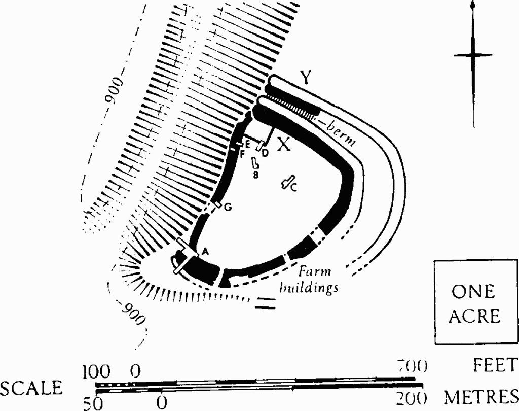
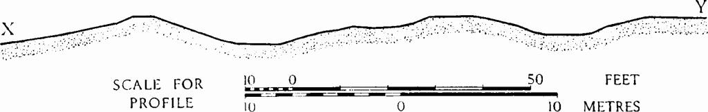
Stanton. (1) Hill-fort on Shenberrow Hill. Plan and profile.