Ancient and Historical Monuments in the County of Gloucester Iron Age and Romano-British Monuments in the Gloucestershire Cotswolds. Originally published by Her Majesty's Stationery Office, London, 1976.
This free content was digitised by double rekeying. All rights reserved.
'Whittington', in Ancient and Historical Monuments in the County of Gloucester Iron Age and Romano-British Monuments in the Gloucestershire Cotswolds, (London, 1976) pp. 124-128. British History Online https://www.british-history.ac.uk/rchme/ancient-glos/pp124-128 [accessed 12 April 2024]
WHITTINGTON
(12 miles N. of Cirencester)
The Romano-British major settlement at Wycomb (2), partly overlying an Iron Age occupation site, had paved streets and a temple, but no enclosing wall. The site of the Roman settlement was abandoned before the creation of the former parish boundary with Dowdeswell, which crossed it. The Roman villa (3), on the other hand, was succeeded by Saxon settlement in its immediate vicinity. A terrace-way just W. of the villa, is on a possible line of the White Way from Corinium; coffin burials to the S. in Sandywell Park (fn. 1) were close to this line.

Monuments in Whittington.
Allegedly Roman metal objects were discovered c. 1865 during clearance of Whittington Wood, 1¼ miles N.W. of (3), probably near SO 997214. Traces of 'foundations and pavements' and two or three Constantinian coins were found 'at a little distance' from the wood. (fn. 2) Scattered Romano-British potsherds have been picked up on arable ground sloping gently E., just S. of Arle Grove (SO 994215), which appears to be a remnant of Whittington Wood.
The lower part of a Roman column, now at Whittington Court, but recovered from a cottage in the modern village, is of uncertain provenance, probably local (Plate 30).
(1) Iron Age Settlement (SP 027205), Syreford gravel pit and Wycomb; see (2).
(2) Romano-British Settlement (SP 028201), Wycomb, Syreford, covers about 28 acres of almost flat ground, just E. of the river Coln. At this point the Gravel is capped in places by a very thin layer of Clay. The settlement is known from extensive digging by W. L. Lawrence in 1863–4 prior to the construction of railway embankments across the site; also from more restricted excavation and observation of exposed structures in recent years, from air photographs (Plate 48) and from an abundance of surface debris when ploughed. The settlement extends into the modern parish of Andoversford as far as the railway embankment at S.W., and was thought by Lawrence to reach at least as far as the Andoversford Inn (SP 02391977). The accompanying plans show only part of the structures thought to exist. There are indications that the settlement was preceded by Iron Age, Bronze Age, Neolithic and Mesolithic occupation. Air photographs show traces of circular ditched enclosures adjacent to Lawrence's feature 5 and, possibly, also S. of the temple. Around the former area, now quite flat, there is a substantial scatter of worked flints, including microlithic cores and arrowheads both leaf-shaped and barbed-andtanged. The Iron Age settlement is marked by finds at both N. and S., and other Iron Age finds under the heart of the Roman settlement may perhaps be inferred from early accounts. First-century Roman coins are known from S. and N. parts of the settlement, though most of the coins are of the 4th century. Samian pottery has been found in most parts.
Occupation debris of the pre-Roman Iron Age, including Iron Age 'A' pottery, burnished black ware with thin incised decoration and calcite-gritted pottery, has been found in recent disturbance within the area of Old Syreford gravel pit, in the N.W. corner of Wycomb field. Some of the debris came from a shallow pit immediately beside the surviving limits of Roman surface relics. Similar finds were made in the vicinity in 1934 and 1937 (TBGAS, 71 (1952), 16). At this point most of the surface levels have been totally removed. During the excavations of 1864 'rude British' pottery was noted beneath buildings 6 to 11 (Lawrence's plan). In 1936 Iron Age pottery was found near Roman coins and pottery (PCNFC, XXVI (1936), 105). 'British Roman' (unidentified British ?) coins came from the original excavation, but they cannot now be traced. Three Dobunnic coins, one of them inscribed EISU, and two iron brooches of the Iron Age have recently been found by Mr. W. Cox in an excavation immediately S.W. of Black Close; another brooch of similar type has been found in the temple area. We are grateful to Mr. Cox for this and for much other information, some of it embodied in the accompanying plan.
The span of Roman coins is from Vespasian to Arcadius, the later coins predominating. A late Roman buckle has recently been found. The field-name Wycomb, formerly Wickham, may indicate that the site was recognised by Saxon immigrants as a Roman settlement, the wic possibly denoting a vicus (Med. Archaeol. XI (1967), 95–7; PNG, I, 185). There is no evidence of Saxon or later occupation.
The straight paved road running through the site from N.E. (its end corresponds with the limit of surface debris) to a point of apparent bifurcation was found by Lawrence to be 8 ft. to 10 ft. wide, and to embody large stones set vertically and smaller stones laid flat; it had been noted by him as a crop-mark in 1863. The plan published in 1864 after excavation is not sufficiently accurate in all its details to admit conflation with data from air photographs and recent ground observations, but in the accompanying illustration the full recoverable street system is shown on an adjoining diagram, together with the probable position of some of the early excavated features, and of others more recently noted. The transverse roads suggest buildings over a length of at least 600 yds., and accounts written in 1864 insist that foundations were discovered over all parts of the field, though no particulars were recorded. Black earth is still widespread. Recent excavation between Black Close and the railway embankment at S.W. has revealed a ditch with a rounded bottom, some 20 ft. across and over 4 ft. deep, roughly in line with the main axial road seen on air photographs. The ditch had been entirely filled with rubbish of late 4th-century date, including much burnt matter, and substantial quantities of large building stones had been thrown in from the S. side. Also in this area were at least three ovens and numerous other pits and ditches. Six unaccompanied skeletons lay sprawled on the Roman surface, immediately by the stream. A Romano-British urn with a cremation was recently found on the edge of the gravel pit in the N. of the settlement (TBGAS, 87 (1968), 202).
The road proceeding S.W. out of the settlement is aligned with the old parish boundary between Dowdeswell and Withington, suggesting that a roadway once extended S.W. to an intersection with the possible line of the White Way at about SP 017191 (see discussion on Roman roads, p. xlv), but there is no other indication of any road continuing beyond the bounds of the settlement, and recent excavation near the new by-pass at S.W. has disclosed no paved road on that line.
Recorded widths of foundations excavated in the 19th century varied generally between 1½ ft. and 2½ ft., but the wall at 9 on Lawrence's plan was about 3¼ ft. thick, with stone courses 10 in. high. All footings were of Oolite and there was little trace of tile. (Recently a limestone block with two pairs of shallow parallel grooves has been found near the temple.) Floors were 'mostly of stone, laid in cement and gravel concrete'. It is not clear if wall 5, 75 ft. long and thought to be part of a theatre, is an isolated fragment; it was said to be of 'strong rough masonry' although its recorded thickness was only 2⅓ ft. Buildings 6–9 and 11 were regarded as elements in a single arrangement, with a mass of pitched pavement between the component structures, the whole being built over a two-foot layer of black earth containing some pottery 'probably British'. The N. wall of 6 was described as 'heavy'. No. 13 was part of 'a large residential building destroyed by fire'; apsidal pitched stone foundations projected on its E. side; 'hypocausts', 'striated' tiles and tesserae were found in the area. Between 13 and 15 was a mass of foundations, including 18, and 'pavements, forges and fireplaces'. No. 15, measuring 41 ft. square internally and best regarded as a Romano-Celtic temple, was built over the remains of a smaller two-cell structure, No. 16; it apparently had a raised cella. Part of a pediment was reported and broken columns lay near. No. 29 was a stone-lined pit containing a 'rude fibula' and pottery with a cremation. Nos. 24, 26 and 28 were probably parts of a paved 'street'. Spread gravel has recently been found on some of the presumed spur tracks off the main street lines. 'Large' foundations at No. 30 were crossed by the old parish boundary, now removed, and continued into Black Close. Traces of building have since been found some 150 yds. S.W. of the parish boundary, but further S.W. on the line of the modern by-pass, neither buildings nor paved street were found.
Finds include the following—Votive Objects: two stone panels, each originally with three figures, the better-preserved showing a genius cucullatus and two hoodless deities; two small stone idols carved overall, one with a large figure (probably a local god) and two small figures on the main face, the other with a ? goddess outlined on one side; a bronze statuette of Mars, 3 in. high (a note by J. M. C. Toynbee on the hitherto unpublished figures will appear shortly in TBGAS); a bronze model axe, now lost. Coins: over half of some 1,100 coins found during the 1863–4 investigations came from the area of the temple; the earliest was a silver coin of Domitian, but most were 'late'; recently a coin of Vespasian was found in the extreme S.W., and one of Domitian was found just N. of the railway embankment which crosses the site; many other coins have been noted from time to time since 1799, including more than a hundred in the S.W., on and near the line of the new by-pass. Pottery: in abundance, including plain and figured samian ware, Oxfordshire red colourcoated ware, and mortaria. Brooches: several, including three of pre-Conquest type made of iron (one found near the temple), and one of Hod Hill type from the bypass area. Iron Tools: including spoon-bit, cold chisel, mason's trowel, knives and pruning hook. Other small finds include a late Roman buckle (Hawkes, type I (b)); locks, keys and latch-lifters; small pieces of fine glass; styli; dividers; toilet articles; a bonc chape. Querns: several, of Andernach grit. Animal bones: large numbers, including Bos longifrons.
Most of the stone objects and the statuette of Mars, as well as finds made in recent excavations, are in private possession. Some are in Stroud Museum. Apart from these the bulk of surviving finds is in Cheltenham Museum.
C.U.A.P., OAP ASB 13 15–17: ASM 31–6.
Gent. Mag. N.S., XV, pt. 2 (1863), 627; XVI, pt. 1 (1864), 86–8; XVII, pt. 2 (1864), 85–7 (with plan), 432–3. PSA, 2nd ser. II (1863–4), 302–7, 422–6. Arch J, XXI (1864), 96–7. Witts (1883), 70. PCNFC, XXVI (1936), 105; XXX (1949), 154. TBGAS, 78 (1959), 161–2. Toynbee (1964), 181. Lewis (1966), 3, 51. Trans. Birmingham & War. Arch. Soc., 85 (1972), 147 (buckle).
The original excavation plan, scale 66 ft. = 1 inch, is in the Library of the Society of Antiquaries of London (Red Portfolio, Glos.).
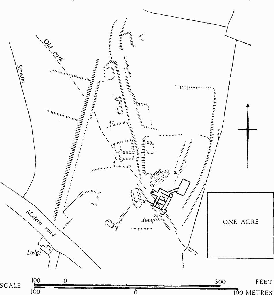
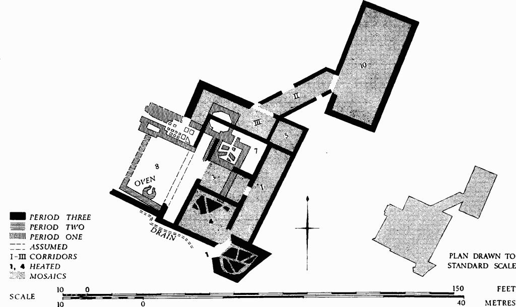
(3) Roman Villa (SP 01572051), in 'Cow Pasture', lies 300 yds. E.S.E. of Whittington Court at the S. end of the observable remains of the deserted Saxon and mediaeval settlement of Whittington, near the N. edge of the Vale of Andoversford (map, p. 124). The nearly level site, on Clay over the Upper Lias at 590 ft. above O.D., falls gently S. to the Anna Stream, about 100 yds. distant. It is near a natural springline. Excavation by Mrs. H. E. O'Neil (1948–51) exposed three structural periods from the 2nd to the early 5th century (plan, p.128).
The first period, within the 2nd century, was represented by a small bath block, with apodyterium, tepidarium, caldarium and cold plunge, assumed to belong to another building which was undiscovered; walls possibly of Roman date were detected just S.W. of the villa under a mediaeval cottage (X on the plan on p. 127). Earthworks S.W. of the villa have an alignment which accords better with the villa as a whole than with the later settlement; the bank between x and y, where there probably was a structure, exemplifies this. In the second period, probably the second quarter of the 4th century, a small winged corridor house with an unusual apsidal room (1 on the plan), integrated with the old bath building, was constructed. In the third period, shortly after the second, the bath block was abandoned as such and was incorporated into enlarged rooms; at the same time the house was extended by the construction of a large hall (10); this was connected with the enlarged kitchen (8) by long corridors (I–III) around and outside the house. All the corridors and all the rooms except Nos. 7 and 8 had tessellated pavements, the surviving patterns being mainly geometric, with some foliate detail. Rooms 7 and 8 had gravel mortar floors. Two living-rooms (1 and 4) were heated. No bath block was found for the final period. Courtyards of rammed earth lay S.E. and N. of the house, with doorways giving access from corridor II.
The villa fell into decay in the 5th century, and a hearth in room 7 probably belongs to that period. Only two rooms, Nos. 3 and 10, suffered from fire and the collapse of timbers. Charred wheat on the floor of room 3 indicates that agriculture was being carried on in the last phase, after the abandonment of the villa as a fine house. There had been very extensive robbing of small objects and of building stone. Pottery and seven metal objects of the mid to late Saxon period were found. In the 13th century or thereabouts the W. wall of an enclosure, now represented by earthworks at 'a' on the site plan, was built across the remains, and shallow cultivation took place over the site. The E. wall of the enclosure formed one side of a track, 23 ft. wide, which bounded the villa site on the east. The street of the mediaeval village crossed the W. side of the villa.
The villa walls, 1¾ ft. to 3 ft. thick, were of local Oolite in well-laid courses. In the first and second periods many of the footings were of pitched stones. Some Old Red Sandstone slabs were used as flue covers. Roofing was of local slate and Old Red Sandstone. Baked clay occurred only in tesserae, in certain pilae, in tiles of the plunge-bath floor and, copiously, as crushed brick in the mortar bedding for the tessellated floors. The first period was characterised by small axe-dressed blocks of white freestone on footings of larger undressed white freestone blocks; the two later periods had walls of larger, roughly dressed yellow Oolite.
Whittington. (3) Roman Villa, 'Cow Pasture', and adjacent earthworks.
Displaced sculptured fragments included the base of a small stone column, a broken impost with a rosette carved on one face (Plate 30), a block (1 ft. 6 in. by 1 ft. 4 in.) with a flat dressed face and with the opposite side cushion-shaped, and stone blocks (found E. of the house), probably voussoirs. An unprovenanced column base shown on Plate 30 possibly comes from this villa. In the third period a stone drain skirted the S.W. side of the house, passing the kitchen (room 8) which, in its final phase, was 33 ft. long by at least 22 ft. wide, possibly with a lean-to roof. In the second period the kitchen had had an oven 2 ft. across, but this was covered by the gravel mortar floor of the final phase.
The eight mosaics (Plate 9), all of 4th-century date, include in corridor II one of the most ambitious corridor pavements yet found in Britain (Toynbee (1964), 234). The mosaics of room 10 and of corridors II and III were made in the third period and are very similar in constructional detail and form of pattern. Tesserae are of white, grey and blue-grey local limestone, of Old Red Sandstone, and of red tile—some of the latter made from box-flue tiles. The cubes vary in size from ¾ in. to 21/8 in., the average being 1¼ in. Room 3 was unusual in having both border and pattern made with large tesserae.
Whittington. (3) Roman Villa, 'Cow Pasture'.
Large quantities of wall plaster came from corridors II and III; dark crimson and pale blue were noted.
Dating evidence was meagre, but it was greatly helped by the distinctive building detail used in the different phases. Potsherds indirectly date the first period, and a coin of Constantine I embedded in the mortar underlying corridor III gives a secure date before which the third-period works cannot have started. Most of the 114 coins were later than 330, the range extending through the 4th century; 17 coins were Theodosian. Small finds included a turned Kimmeridge shale pot-lid, spindle whorls and coal.
TBGAS, 71 (1953), 13–87.