Ancient and Historical Monuments in the County of Gloucester Iron Age and Romano-British Monuments in the Gloucestershire Cotswolds. Originally published by Her Majesty's Stationery Office, London, 1976.
This free content was digitised by double rekeying. All rights reserved.
'Bourton-on-the-Water', in Ancient and Historical Monuments in the County of Gloucester Iron Age and Romano-British Monuments in the Gloucestershire Cotswolds, (London, 1976) pp. 17-21. British History Online https://www.british-history.ac.uk/rchme/ancient-glos/pp17-21 [accessed 26 April 2024]
BOURTON-ON-THE-WATER
(15½ miles N.E. of Cirencester)
The position of Bourton in the angle between the R. Dikler and the R. Windrush, mostly on gravel, on the line of the 'Jurassic Way', has favoured settlement since the Neolithic period. (fn. 1) Within Salmonsbury (1) there is evidence to suggest continuity of occupation through most of the Iron Age and Romano-British periods. In the latter period Bourton became a major settlement— a town without walls—and the Iron Age defences ceased to be significant. Attracted by the Foss Way, where a posting station probably stood near a paved ford and a footbridge, dense occupation developed in the area of Bourton Bridge and also along the Foss Way to S.W. A metalled road forked E. from the Foss Way. The area occupied by Roman settlement is at least 55 acres. Buckle Street, the road N. from Bourton Bridge, may be Roman in origin (see p. xlv and map, p. 18).
The accounts below owe much to information kindly given by Mrs. H. E. O'Neil and Dr. G. C. Dunning.
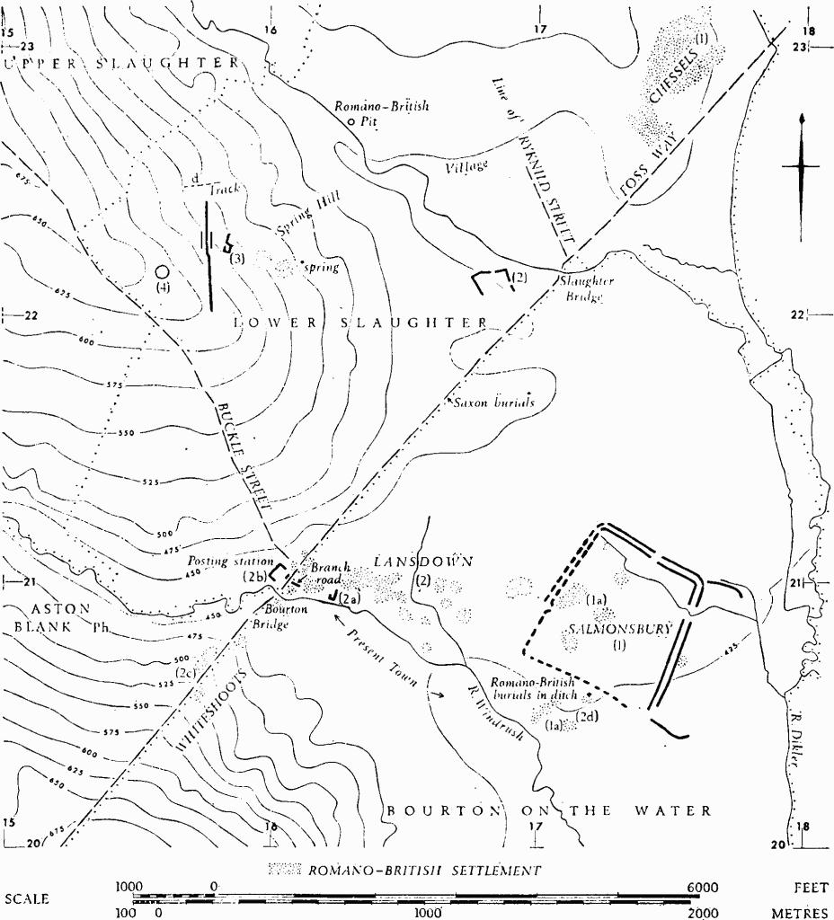
Monuments in Bourton-on-the-Water and Lower Slaughter.
(1) Salmonsbury (SP 173208), an Iron Age fortified settlement of hill-fort proportions occupying a gravel platform between the R. Dikler and R. Windrush, about 425 ft. above O.D., covers 56 acres and is bounded by two close-set ramparts, each with an external ditch. Entrances are in the N.W. and N.E. sides and another gap probably occurred on the S.E.; little is known of the S.W. side. Banks, each with external ditch, extend the line of the outer rampart S.E. from the S. and E. angles, defining an annex of perhaps 15 acres flanking a naturally marshy area. An intermittent stream flows through the interior and out at the S.E. The defences survive clearly only in parts of the S.E. and N.E. sides; information about their position elsewhere derives from close surveillance of chance exposures and from air photographs. Excavation by G. C. Dunning in 1931–4 indicated that some Iron Age 'A' settlement preceded the building of the rampart. The enclosure and main occupation were of Iron Age 'B' culture with 'Belgic' elements appearing at the end of the period. Abundant finds include a large hoard of currency bars. The defences were disused in the Roman period, but much of the interior continued to be occupied (see (1a)). Saxon objects have been recovered from Romano-British building sites, and Saxon burials have been found in or near the ramparts (TBGAS, 56 (1934), 5). The name Sulmonnes Burg, 'ploughman's stead', is first recorded in 779 (PNG, I, 195). Courts of the Liberty or of the Hundred of Salmonsbury assembled traditionally by the entrance in the N.E. side. The present field pattern indicates that the interior was largely taken up by arable strip fields before modern enclosure (C.U.A.P., OAP AJL 48).
The banks where best preserved are up to 3 ft. high. Excavation in 1931–4 was concentrated on a section across the defences at S.E. (site I), entrance structures at N.E. (site V), occupied areas immediately behind the defences at S.E. (site I), N.W. (site III), and towards the centre (site IV). Sections were also dug across the bank and ditch which project from the N.E. angle (sites VI, VII). At site I the spread inner bank was 60 ft. across and its ditch was originally 36 ft. wide and 12 ft. deep; the almost levelled outer bank, immediately beyond, was 40 ft. across and its ditch was 18 ft. wide and 9 ft. deep, with a notably sharp V-shaped cross-section. The banks were of gravel and there were indications of a revetment of Oolite slabs near the crest of the inner rampart. Other slabs in the ditch fill suggested the possibility of Roman slighting. In 1881, when the entire circuit was still traceable, 'masonry' was noted in the main rampart, then said to be about 5 ft. high. Large worked stones were seen on its line in 1925. Subsequent observations by Mrs. H. E. O'Neil have demonstrated the position of an entrance in the N.W. side, S. of site III. The excavated entrance at N.E. (site V) was 28 ft. wide between curved terminal limestone revetments; spur walls narrowed the entrance on the inside. A storage pit to one side of the entrance, filled with stones, was crossed by an entrance track 16 ft. wide and worn to a depth of 2 ft. The entrance was subsequently blocked by a row of six large posts and by a stone wall.
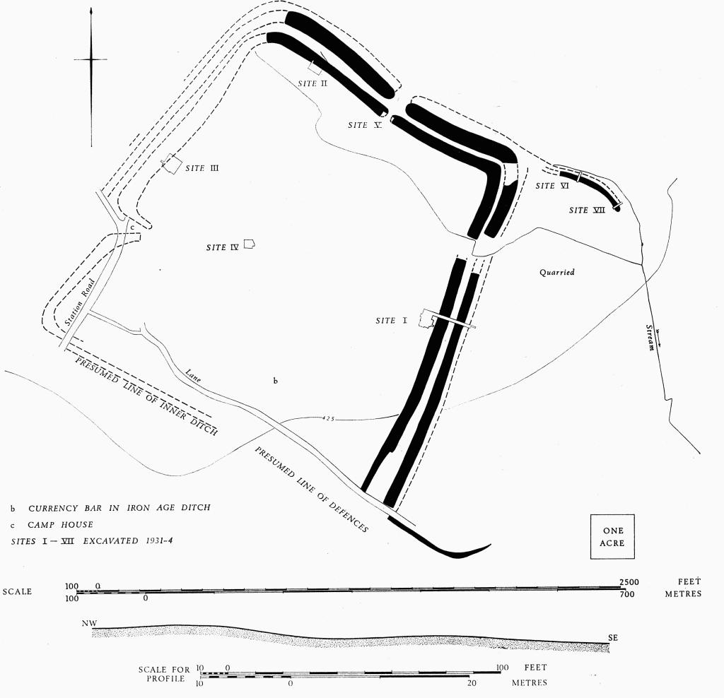
Bourton-on-the-Water. (1) Salmonsbury. Iron Age fortified settlement. Plan and profile.
Pre-rampart occupation discovered at site I included five apparently shallow pits sealed by the core, 24 ft. wide, of the inner bank. An iron hook, a bronze loop and Iron Age 'A' sherds lay in or on the old ground surface. Early Iron Age sherds were found in the ditch fill, and a relatively large number of Romano-British sherds low in the fill indicated that the defences had been made—or scoured—not long before the Roman conquest.
Two huts at site I, each 22 ft. in diameter, were defined by rings of post-holes and a central post; both huts lay immediately within a single curved ditch. Portions of similar curving ditches were found at site III, where they had been cut by a 'Belgic' ditch and a palisade trench, apparently forming part of an enclosure 60 ft. wide. The enclosure ditches had been backfilled and covered by rough paving on which were at least two stone-footed round huts, one only 11 ft. across. Such paving was characteristic of the 'Belgic' phase; it was found also in site IV where a pattern of successive curved ditches, and at least one round hut, 26 ft. across, were overlaid by paving.
Pits were found on all sites. The largest number of storage pits was at site I. There were two skeletons in pre-Belgic pits at site IV and three at site III.
The bank projecting E. from the N.E. angle was of clay and gravel, 32 ft. across and 3 ft. high; outside it was a ditch, presumably once wet, 18 ft. across and about 2 ft. deep, filled with black mud. The present stream lies 6 ft. beyond. Air photographs suggest that this ditch was continuous with the outer ditch of the main enclosure. A crouched burial, thought by the excavator to be probably of the Iron Age, was found in the bank.
Finds, apart from those mentioned, include Iron Age 'B' pottery, some with incised (not stamped) decoration, from huts and pits. 'Belgic' pottery at site III was associated with an unusual fluted pedestal vase (TBGAS, 56 (1934), 3–5; Bagendon, 20 and 30). Two stratified Dobunnic silver coins were found; one belongs to Allen's uninscribed class 'C', the other, inscribed Anted, was associated with a Claudian coin and pottery, and perhaps with another uninscribed coin of class 'B' (D. Allen in Bagendon, 96–7 and 248). A gold quarter stater of Tasciovanus has now been lost (D. Allen in IASB, 221; TBGAS, 83 (1964), 15, n). A hoard of 147 currency bars, of which 40 survive, was found in 1860, buried as though in a chest in the area of site II. In more recent years a single currency bar was found at 'b' on the plan, in an area with Iron Age ditches, and two fragmentary bars were found in the make-up of 'Belgic' paving (PPS, XXXIII (1967), 328–9; R. F. Tylecote, Metallurgy in Archaeology (1962), 210–11; cf. Antiquity, XIV (1940), 427–33). Thirteen brooches of iron and bronze included three of 'Camulodunum' type III. Other finds were a carved limestone 'idol' (cf. Ant J, XIV (1934), 59–61), saddle querns, a gritstone 'beehive' quern of Hunsbury type (Antiquity, XV (1941), 20; Trans. Leics. Arch. Soc., XXVI (1950), 77), iron bill-hooks, bone needles, ornaments and knife handles, stone spindlewhorls, and bones of ox, sheep, pig and goat.
Finds are in Gloucester City Museum, Corinium and Cheltenham Museums, Ashmolean Museum, B.M., Bristol City Museum, National Museum of Wales, and in private hands.
N.M.R., OAP SP 1720/3/325–6; 1721/2/319, 327–30. C.U.A.P., OAP AJL 48–9.
Camden, Britannia (ed. Gough, 1789), 279. Rudder (1779), 303. JBAA, XIX (1863), 104. Playne (1876), 209. Witts (1883), No. 88, 43–4. TBGAS, VII (1882–3), 16; XLVII (1925), 48–9. PCNFC, XXIV (1931–2), 145–8. Antiquity, V (1931), 489–91; VIII (1934), 351–2 (excavation). TBGAS, 56 (1934), 3–5; 57 (1935), 256–9; 83 (1964), 11.
(1a) Roman Remains Inside and Immediately Outside Salmonsbury (SP 17022052), represented by abundant chance finds, include very large numbers of coins ranging in date from Claudian to late Roman. Structural remains include 'floors' and 'walls'.
A rectangular 'hut' in the centre of Salmonsbury was about 14 ft. wide and at least 38 ft. long; it lay over a circular Iron Age hut. Two rubbish pits and two drainage ditches yielded late 1st-century and early 2nd-century pottery. A floor had 3rd-century pottery beneath it and 4th-century pottery above.
When a drainage trench was cut in 1946 in the field S. of Salmonsbury, a series of rubbish pits was observed over 2 acres, reaching the road by the R. Windrush; they varied from 6 ft. to 11 ft. across and were 2¾ ft. to 3¾ ft. deep. In the field S. of this (about SP 172204) air photographs show a narrow ditch with a rounded angle, possibly part of an enclosure. Finds, including a gilt bronze buckle, were mostly of the 2nd century.
N.M.R., OAP SP 1719/6.
TBGAS, VII (1882–3), 16; 57 (1935), 234–59. Ant J, XXIX (1949), 85–6. JRS, XXIV (1934), 212.
(2) Romano-British Settlement, Bourton Town Area, S.E. from SP 161210 and W. of (2), is known mostly from chance finds. Settlement covers at least 30 acres along the R. Windrush and a tributary, includes one excavated house site (4) and connects with the settlement area around the probable posting station (5). Development along the Foss Way (8) extended S.W. of this, beyond the river, on Whiteshoots Hill (6). Burials have been noted only S.E. of the town (7).
A gap of about 250 yds. separates the main concentration of recorded remains, W. of a stream along the line of the present High Street, from those in Salmonsbury and on its fringes (2).
A branch road ran E.S.E. from the Foss Way in the area of (5), past the 'Leadenwell Villa' (4), towards Salmonsbury.
Structures include walls, wells, shallow pits, ovens and floors, but nothing is known of any town walls. Coins range from Republican issues to those of Honorius.
TBGAS, 57 (1935), 234–59; 87 (1968), 29–55. Ant J, XXIX (1949), 85–6.
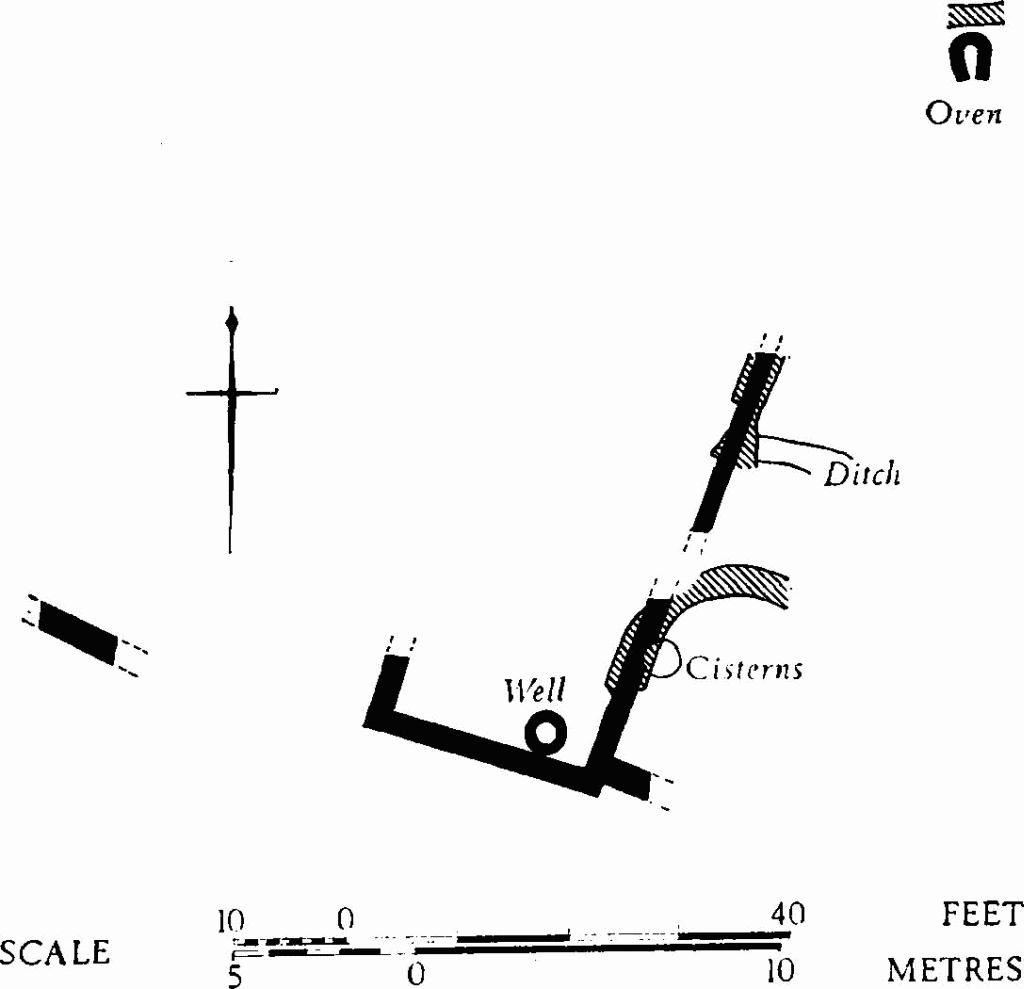
(2a) Roman Buildings, Lansdown ('Leadenwell Villa' and area) (SP 16212098). A courtyard 18 ft. wide with adjacent walls and other features, excavated in 1933–4, lay on gravel just N. of the R. Windrush and 216 yds. E. of Bourton Bridge, in an area that has yielded numerous Roman finds. Four phases were recognised, dating from the 2nd to the late 4th century. There was a well, 8 ft. deep, an ovoid oven and two tub-shaped lead tanks of 40 and 65 gallons capacity; the tanks are now in Cheltenham Museum.
TBGAS, LV (1933), 377–81; 56 (1934), 99–128; 57 (1935), 260–5 (oven). JRS, XXV (1935), 216. Ant J, XXIII (1943), 155–7 (cisterns).
(2b) Romano-British Settlement (SP 16102105), with probable posting station (mansio or mutatio), at Bourton Bridge, covered at least 4 acres immediately around the Foss Way, N.E. of the bridge. The remains were observed and diagrammatically planned by Witts in 1875–81, before the 'posting station' was largely destroyed. The adjacent settlement area was investigated by Mrs. H. E. O'Neil briefly in 1959 and during road widening in 1967. Occupation appears to have been continuous from the 1st to the early 5 th century. The parish boundary follows the road and bisects the settlement.
Building foundations over 5 ft. high and perhaps 240 ft. long were noted during clearance for the railway, as also was the base of a column 9 in. across. The main part of the presumed posting station appears to have formed three sides of a rectangle, perhaps 240 ft. by 140 ft., facing S.E. Occupational layers (including samian as well as 4th-century pottery) together with a wall which probably bounded the fourth side of the courtyard, were found in 1967. Other buildings examined in 1967 were interpreted as providing public services for travellers; they extended along both sides of the road, from the bridge to a point 500 ft. N.E., where the Roman road changes course to S. by about 5°. Features included forges and ovens. There was one short length of very massive wall and near it was a stone column base.
Very large quantities of occupational material recovered in 1875–81 included several hundred coins ranging from M. Aurelius and L. Verus to Constans, samian ware with ten different potters' stamps, horseshoes and spurs. A group of 23 minimissimi probably came from the area.
TBGAS, 57 (1935), 247–59; 87 (1968), 29–55; 91 (1972), 92–116. Num. Chron., 5th series, XV (1935), 275–81, 284–6. Brit. Num. Journ. XXVI (1949), 11, 25, 340–3 (minimissimi).
(2c) Romano-British Settlement (SP 157206–SP 16032092), on Whiteshoots Hill, has been observed on both sides of the Foss Way, extending into Aston Blank parish, over a length of some 500 yds. S.W. from Bourton Bridge (plan, p. 18). Structures include masonry walls. Pottery includes amphorae, samian and late Roman wares. Recorded coins are from Gallienus to Magnentius. Two large hoards of folles, datable to 307–18, were found (one as though formerly in a bag) under a deposit of stones. A 'deep trench' is said to run at right angles, E. from the Foss Way about SP 15732060, in front of Whiteshoots House.
TBGAS, 57 (1935), 239, 242–3; 87 (1968), 48–60; also forthcoming; PCNFC, XXVI (1936), 105.
(2d) Romano-British Burials (approx. SP 17102047 and SP 17202055), two, have been reported S.W. of Salmonsbury, one in a sarcophagus.
TBGAS, 57 (1935), 243.
(3) Foss Way, Roman Road (SP 137175–SP 172222), generally overlain by the modern road, follows a N.E. course for 3½ miles on the parish boundary, between 677 ft. and 440 ft. above O.D., on Inferior Oolite, Cotteswold Sand, Upper and Lower Lias, and river gravel. The road crosses two streams and the R. Windrush; at the latter (Bourton Bridge) there was a paved ford and a footbridge. Local deviations appear to be for topographical reasons. There is a slight deflection in, or at the E. entrance to, the Romano-British settlement (2b) at Bourton Bridge, the main alignment being rejoined a corresponding distance S.W. of the bridge. Excavations by Mrs. O'Neil have shown details of structure and of disturbance, relationships with structures of the settlement, a road diverging towards Salmonsbury (2), and a junction with Ryknild Street ('Condicote Lane') immediately E. of Slaughter Bridge (SP 171222). The road is followed by the parish boundary, which therefore divides the settlement area. Eight pagan Saxon burials (SP 166217) in the road ¾ mile N.E. of (5) indicate disuse of the agger.
The agger was built of gravel layers on pitched stones, but 260 yds. N.E. of the ford it was composed of small stones and yellow silt on a bed of rammed slag. A kerb was found in the area of settlement (2b), where also at least one building impinged on the road. The only observed width is 22 ft.
The Roman ford, under the present bridge over the R. Windrush, had a surface of large pebbles with, in places, two courses of rough stone blocks. The presence of a footbridge on the E. side of the ford was deduced from the discovery of small piers, possibly about 2¾ ft. square originally, built of cemented rough Oolite rubble.
Some 60 yds. N.E. of the ford a branch road led E.S.E., but the actual junction with the Foss Way was not observable. Its course was established by excavation 100 ft. from the junction, where buildings lay beside it on the S. The branch road was 18 ft. to 24 ft. wide, cambered, and built of pitched stone and gravel. Samian ware was found below the kerb of its first phase. It was apparently rebuilt early in the 3rd century.
TBGAS, 87 (1968), 29–55.
(4) Settlement (SP 174194), undated, shows as unclear crop-marks of interlocked enclosures over some 8 acres of the Santhill gravels immediately W. of the R. Windrush. The remains of a Roman building with heated rooms have been noted close to the confluence of the R. Windrush and the R. Dikler. Hut floors and a well have also been noted in the area.
N.M.R., OAP SP 1719/1–4 (Baker).
H. E. O'Neil in Studies in Building History (ed. Jope, 1961), 29.