An Inventory of the Historical Monuments in the County of Cambridgeshire, Volume 1, West Cambridgshire. Originally published by Her Majesty's Stationery Office, London, 1968.
This free content was digitised by double rekeying. All rights reserved.
'Papworth Everard', in An Inventory of the Historical Monuments in the County of Cambridgeshire, Volume 1, West Cambridgshire, (London, 1968) pp. 196-198. British History Online https://www.british-history.ac.uk/rchme/cambs/vol1/pp196-198 [accessed 24 April 2024]
In this section
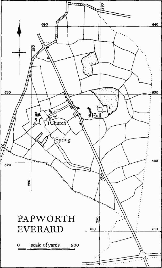
33 PAPWORTH EVERARD
(O.S. 6 ins. TL 26 S.E.)
Papworth Everard takes its name from Evrard de Beche (d. 1175); it has also been distinguished from the twin settlement to the N. by the epithets 'Little', 'Over', etc.
The village seems to have started along a small comparatively steep-sided valley between the church (Monument (1)) and a spring at N.G. TL 28356235 (see Monument (6) Village remains). The site is only a short distance W. of Ermine Street.
Papworth Everard
The parish of 1157 acres has comparatively regular boundaries on the E. and S.W. On the N.W. it is divided from Papworth St. Agnes by the road to the N. from Gamlingay and Eltisley. The land, varying in altitude from over 217 ft. to about 70 ft., drains by small streams flowing N. Oxford clay predominates, except for an area of glacial gravel W. of the church.
When the parish was enclosed by act of 1815 (map of 1818 in C.R.O.) it was almost entirely in one ownership; and the open-field system, remains and traces of which are described below (Monument (8)), had already disappeared. A pattern of concentric field boundaries radiating to the N. and E. from the vicinity of a moated site (Monument (7)) taken with field names (map of 1825 in C.R.O.) suggests successive emparking. This has obviously at one time extended beyond the Ermine Street to the W.
The present direct line of the main road through the parish follows the Roman road. Field boundaries on the O.S. 6 ins. and small irregularities in the boundary with Papworth St. Agnes, now adjusted, suggest that there has been at one time a N. and S. route along the ridge between N.G. TL 289622 and 281639, passing immediately E. of the churchyard. Short lengths of this road still survived in 1813 (map, B.M. Add. MS. 36278 E); these had diminished by 1818 and today even the field boundaries have been grubbed up. Between 1820 and 1825 there were evidently proposals for realigning the turnpike approximately on this old course (Baker's map of Cambridgeshire, 1821) but these were apparently dropped. Re-enlargement of the park to form a worthy setting for the recently erected Papworth Hall (Monument (2)) may have been the reason. Something of the same sort could account for the original diversion, although Papworth's exceptionally tenacious and slippery soil must always have made the going difficult along the ancient highway.
There are few monuments in the village which is dominated by a large hospital and related modern development. A strip of land in the extreme S. of the parish beyond the St. Neots road was occupied in 1825 by a planned agricultural colony, with allotments in a field to the N.E. on the boundary with Eltisley; the buildings no longer exist, although the strip is still separately fenced.
Ecclesiastical
(1) Parish Church of St. Peter stands in a churchyard which has been extended on all sides owing to the pressure of modern burials. It was virtually rebuilt in 1850 at the expense of W. H. Cheere, and others, in memory of his mother. It was lengthened W. in 1870. The fabric had already been extensively damaged in 1741 when the tower fell 'after a very great storm' (B.M. Add. MS. 5810, 81). The foundations of this tower are reported to have been found in 1870 when the W. extension of the nave was under construction.
The walls of the chancel and nave, including the buttresses, are however of 13th-century origin, with the exception of the E. wall of the chancel, which is probably of the 17th century, and the W. bay of the nave. The latter incorporates reused mediaeval material in the plinth, buttresses and jambs of the W. window.
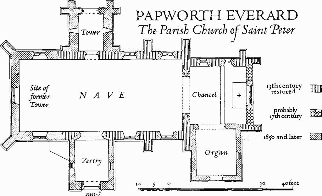
Papworth Everard, the Parish Church of Saint Peter
Fittings—Bell: small, by Joseph Eayre, 1743; a faculty for disposing of the earlier bells was applied for in the previous year. Font: plain octagonal bowl and stem, 13th-century. Monuments: In nave—on N. wall (1) of Edward Morden, 1812, his wife Charlotte, 1861, and his sons John Atterbury Morden, 1826, and William Morden, 1839; on S. wall (2) of Charles Madryll Cheere, 1825, neo-Greek wall monument by Gaffin, London; (3) of 'remains of 28 persons in the family line of the late Edward Morden', buried between 23 Nov. 1634 and 24 March 1839; tablet dated 1850. In churchyard— to S.E. of chancel (4) broken 17th-century headstone, inscription not read; W. of tower (5) of Charles Madryll Cheere, as in (2) above, table tomb. Tiles, in the chancel, of c. 1850, record three other burials. Plate: includes a cup, paten, alms-dish and flagon, all London 1843, inscribed and presented in that year. Table: with turned legs, moulded front stretcher, top rail chip-carved and with shaped brackets; 17th-century. Tiles: in chancel, composition with roundels of the Lamb of God, and emblems of the evangelists; inscription on the risers of the steps records the rebuilding of the church in 1850, the tiles themselves being approximately of that date.
Secular
(2) Papworth Hall, designs for which by George Byfield were exhibited at the Royal Academy in 1809, was built for Charles Madryll Cheere (d. 1825). Some alterations have been made in the early years of the present century, and more recently to accommodate the administration of Papworth Hospital.
The house is two-storeyed, square on plan, of brick covered with stucco; low slated roofs are masked by a parapet above a moulded cornice. The windows generally are sashes, those on the ground floor being taller than those above.
The W. or principal front has an Ionic portico with four giant unfluted columns rising to a pedimented entablature, the cornice of which returns from the main face. A single flanking bay either side has ground-floor windows divided into a pedimented central and narrower side lights under a blind segmental head. The front door is in two leaves, each of three panels, the middle of which is circular; the rectangular fanlight has a cast-iron frame and projecting lantern.
The S. elevation is in seven bays, three of which form a slightly projecting pedimented centre piece; a semicircular porch, supported on two free-standing Roman Doric columns and two corresponding attached half shafts, has a garlanded frieze rising to a cast-iron railing; access to the balcony so created is by a larger window with consoles supporting a shallow hood. The E. elevation has a central recessed portico of two giant unfluted Ionic columns with pilastered antae; the side pieces are each of two bays. Both porticos have added first-floor balconies. On the N. are lower offices, original but much altered.
The interior is divided into three compartments by two E. and W. spine walls. The W. portico leads into an Entrance Hall, floored with grey marble, the E. end divided off by two Ionic columns in scagliola simulating red porphyry with corresponding pilasters in the two side and end walls. This E. compartment is lit by a circular aperture in the ceiling enclosed on the first floor by a balustrade. To the S. of this compartment is an oblong ante-room (Plate 134) the two ends of which have rounded angles with niches, and are divided off in each case by a pair of Corinthian columns in yellow scagliola supporting an enriched entablature. Over the niches at the S. end are small panels depicting festive scenes in grisaille. Double doors in the side walls lead E. and W. into principal rooms; that to the E. has an enriched fireplace surround of white marble. The ante-room is balanced on the N. by a stair with stone treads, cast-iron balustrade enriched with leaf patterns and geometrical figures, and mahogany rail.
N. of the domestic wing are a laundry and stables, more or less contemporary with the house, but much altered.
(3) Houses, a pair, two-storeyed, with framed and plastered walls and half-hipped thatched roof.
(4) School and School House, built to a Class-B design, of white brick with thatched roofs, and dated 1843. The main range was open to the collars and served as a class room approached through the front room of the E. cross wing. The W. cross wing is somewhat the larger, and presumably housed the master. The S. elevation is symmetrical, with side porches, three-sided ground-floor bays to either gable end and octagonal chimney stacks at the junction of the main range and wings.
(5) Rectory, now alienated, main block two-storeyed, of Class-U plan but with service wing to N. of two storeys and attic; the whole of brick with hipped slate roofs; c. 1840. S. front symmetrically arranged in three bays with sash windows having marginal panes; to the E. on the ground floor an original semicircular bay with curved sash window.
Earthworks
(6) Village Remains (not on O.S.), on either side of a steepsided valley, S. of the church and around a spring at N.G. TL 28356235. Early 19th-century maps suggest that some occupation continued until a late date. The most conspicuous feature is a hollow-way 30 ft. wide on the S. boundary of the churchyard, where there is a scarp 4 ft. high and 260 ft. long; the degraded S. edge, 3 ft. high, is in a field to the S., now arable. S. of the hollow-way, pottery of the 12th to the 14th centuries have been found and there are 13th- to 14th-century sherds W. of the stream around N.G. TL 283623, perhaps indicating house sites.
(7) Moated site (Class A1 (c); N.G. TL 290628), on the crest of a low hill of boulder clay overlooking Ermine Street 120 yds. E.N.E. of Papworth Hall. It has been identified as the seat of Evrard de Beche (V.C.H., Cambs. II, 37).) The circular moat is 165 ft. in internal diameter. The steep-sided ditch, 35 ft. to 40 ft. wide, 12 ft. deep, V-shaped and partly wet, is crossed by two causeways on the axis of a vista from the house, 42 ft. wide, W., and 13 ft. wide, E. The tithe map of 1825 shows an entrance by a bridge from the N.W. Alterations due to gardening make it difficult to know what was the original form of the earthwork; the sides of the ditch are planted with trees and the interior is a garden.
(8) Cultivation Remains (not on O.S.). Ridge and furrow 100 yds. to 230 yds. long, 7 yds. to 11 yds. wide and 9 ins. high remains in three places, in each case running N.W. and S.E.: in the park around N.G. TL 295634, 18 curving ridges; around 288629, 20 curving ridges; and around 289625, two almost complete furlongs of 20 straight and 23 reversed-S ridges. Almost the whole open-field lay-out of blocks of curving ridge and furrow, much of it reversed-S, can be seen on air photographs; around the church and Fir Tree Farm the traces appear to be those of old enclosures. In 1813 there were three fields, called 'London Brook', 'Wood Brook' and 'South Brook'.
(Ref: map of 1813 (B.M. Add. MS. 36278 E); enclosure map 1818 (C.R.O.); tithe map 1825 (T.R.C.); air photographs: 106G/UK/1490/3230–3, 3252–6, 4343–5.)