An Inventory of the Historical Monuments in the County of Cambridgeshire, Volume 1, West Cambridgshire. Originally published by Her Majesty's Stationery Office, London, 1968.
This free content was digitised by double rekeying. All rights reserved.
'Caxton', in An Inventory of the Historical Monuments in the County of Cambridgeshire, Volume 1, West Cambridgshire, (London, 1968) pp. 34-44. British History Online https://www.british-history.ac.uk/rchme/cambs/vol1/pp34-44 [accessed 12 April 2024]
In this section
7 CAXTON
(O.S. 6 ins. aTL 26 S.E., bTL 36 S.W., cTL 25 N.E., dTL 35 N.W.)
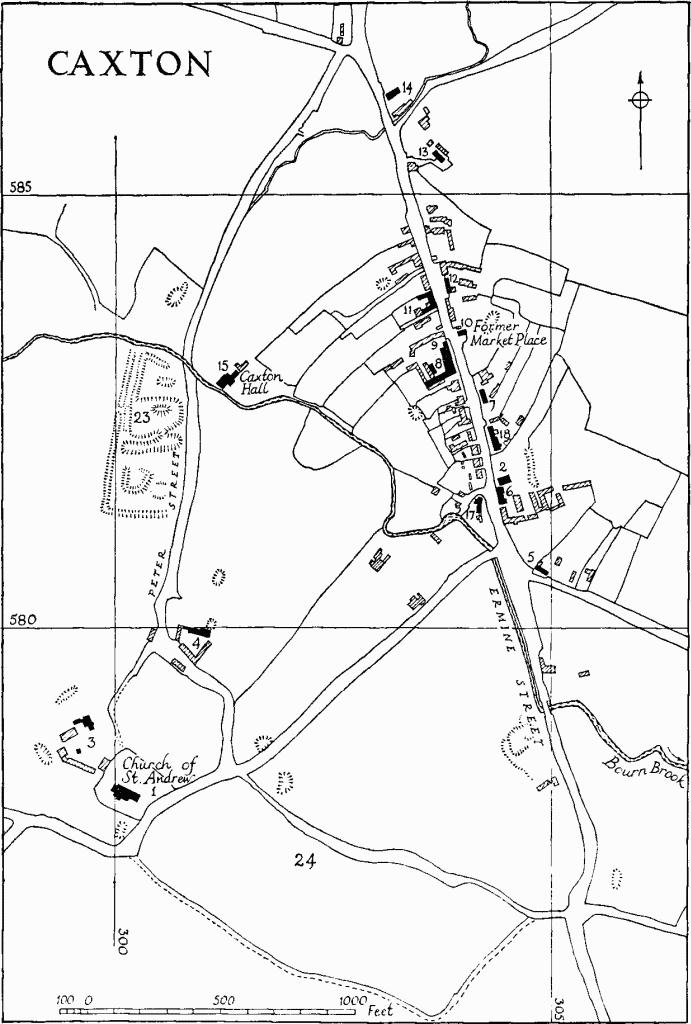
The present village of Caxton lies on Ermine Street, 9 m. W. of Cambridge, approximately in the middle of the parish which comprises 2242 acres, almost entirely of boulder clay and varying in altitude from about 140 ft. to 230 ft. The area is wedge-shaped with its tip pointing to the S. and its butt end against the Cambridge to St. Neots road. Ermine Street and the Bourn Brook, which both form parish boundaries over much of their length, run right through the parish.
The parish is remarkable for its moated sites (Monuments (19), (21), (22) and (23)), identified by W. M. Palmer (History of Caxton (1928)) respectively with the castle of the de Scalers family and with the manor houses of Swansley, Brockholt and Colne). The sites are complementary to the field system, much of the N.W. of the parish being ancient closes, with the three open fields to the S. and E. of the village (see Cultivation Remains, Monument (25)).
Caxton
Caxton is an instance of migration from an earlier site on to a near-by long-distance road. Existing boundaries in the built-up part along Ermine Street are in many cases curved, and no doubt derive from old open-field strips; these curves are even reflected in the buildings themselves (e.g. Monument (11)). The position of the church and the remains of abandoned roads and closes to its E. (Monument (24)) indicate the earlier settlement, which is likely to have extended N. along Peter Street and N.W. towards 'The Moats' (Monument (19)). There are indications that migration was already taking place in the 13th century: a market charter was granted to Baldwin de Freville in 1247, and Palmer may be right in suggesting that the market place opposite Caxton Manor (Monument (8)), which was in use when the weekly market was discontinued in the 18th century, was the original location; a generation later one Bartholomew, a clerk, was in trouble for putting up a wall, five perches long, on the King's highway (Rot. Hund. (1818), II, 542).
Caxton, the Parish Church of St Andrew
Caxton became an important posting station and travel stage at a comparatively early date. John Layer, (quoted in Palmer, History of Caxton (1928), 39), writing in the first half of the 17th century, says it is 'a post town and hath Innes for the receipt of travellers'. After the Restoration it was selected as the county toll point for the North Road turnpike, established by act of 1663, but the gate, which was probably near the manor house and market place, was found to be too easily evaded via Peter Street, and the Cambridgeshire gate was transferred to Arrington in 1668 (V.C.H., Cambs. II, 85). Thereafter the importance of the place gradually declined, although postal matter for Cambridge (the 'Caxton bag') was taken up and set down there during the 18th century. Several of the more considerable standing monuments ((6), (8) and (11)) have been inns.
The surviving open fields were enclosed in 1834, and with them the waste verges, still reflected in the boundaries, either side of the highway N. of the village. A mid 19th-century workhouse, since demolished, and a police station, which survives, were accommodated on sites so provided. Room was found in the same way for one or two otherwise insignificant houses (N.G. TL 30235870, not listed); but there was very little building after the 18th century.
Ecclesiastical
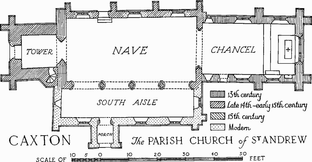
c and d(1) Parish Church of St. Andrew is S.W. of the village and stands in the S. part of a roughly rectangular churchyard bounded on the N. by a ditch and on the curving S. and W. sides by a low bank. It consists of a Chancel, Nave with South Aisle, and West Tower. The walls are of field stones and reused material with clunch and freestone dressings; the roofs are of tile. Among fragments preserved in the church (see under Miscellaneous below) are two of 11th-century character, and a church with some features of this period, in part at least stone-built, is to be inferred. The church belonged to the priory of Lewes until 1351 when it passed to the Dean and Canons of Windsor. The chancel and W. wall of the nave are 13th-century; the remainder of the nave with S. aisle and most of the ground stage of the W. tower are of the late 14th or 15th century; the rest of the tower followed soon after. Arched recesses in the N. wall, balancing the S. arcade and doubtless framing windows, were filled-in in modern times. Restorations were carried out in 1863–9, when the S. aisle and S. porch were rebuilt; and again in 1929–30.
Architectural Description—The Chancel (32¾ ft. by 17¾ ft.) is of the second half of the 13th century, the restored singlestage buttresses, an eroded external string in clunch and the internal string being of that time. The E. window of three lights is modern but is set in an opening with a label and stops of the 14th or 15th century. In the N. wall are three restored windows: the first two are each of two uncusped lights with a trefoil in the head; the third is a lancet rebated internally for a shutter. In the S. wall are two restored two-light windows similar to those in the N. wall but with quatrefoils instead of trefoils in the head. W. of these is a modern doorway with old splays and beyond it a restored transomed lancet rebated internally in both lights. Save where otherwise indicated these openings are all original. The late 14th-century chancel arch is of two moulded orders, the outer continuous and the inner carried on attached part-circular shafts with moulded octagonal caps and moulded bases. S. of it on the nave side are the remains of a blocked 15th-century upper doorway to the rood loft.
Caxton, the Parish Church of St Andrew
South Arcade of Nave
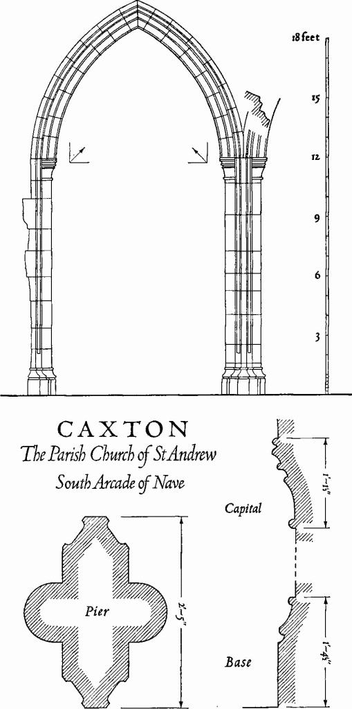
The Nave (45¾ ft. by 22½ ft.) has a N. wall with three modern windows and a 14th-century doorway, between the second window and the third, of two continuous moulded orders with a label. Externally the wall exhibits traces of blocked openings including some jamb stones of a doorway of uncertain date immediately W. of the existing one. Inside, E. of the doorway, a number of straight joints and some areas of modern brick were discernible until recently, probably explicable as blocked wall arcading; these indications are now plastered over. On the S. side is a late 14th- or early 15th-century arcade of four bays with arches of two hollow-chamfered orders, the outer continuous and the inner carried on semi-circular attached shafts with moulded octagonal caps and bases. There is no clearstorey and the weathering on the E. face of the tower, for a nave roof of low pitch, suggests that the arcade was designed without one, although the side walls have evidently been reduced a little in height. The S. aisle and the S. porch are modern, but the S. doorway of two continuous wavemoulded orders is of the 14th century, reset.
The West Tower (12 ft. by 11½ ft.) is 14th- to 15th-century, but may well have been built up on the W. wall of an earlier nave. It is of three stages with moulded plinth and embattled parapet and has a stair turret at the S.E. corner with doorways to both ringing and bell chambers as well as at the foot. The tower arch is of three orders, the outer ones continuous and the innermost carried on semi-octagonal attached shafts with moulded caps and bases. The inserted W. doorway, of two chamfered orders, has a two-centred inner and square outer head with carved spandrels; its splays are carried into those of the late mediaeval window above, which is of three cinque-foiled lights in a four-centred head. There is a small quatrefoil sound hole in each face of the ringing chamber, and a two-light window with four-centred head in each face of the belfry.
The restored late mediaeval Roof of the chancel is divided into three bays by moulded and arch-braced principals; the remaining roofs are modern. At the W. ends of the nave side walls are two decayed late-mediaeval stone roof corbels carved as shield-bearing half angels.
Fittings—Bells: six; 3rd by Joseph Eayre, 1755; 4th and 5th by Christopher Graye, 1672. Brass indents: in chancel—(1) for full-length figure with attached inscription plate, late mediaeval; (2) for full-length figure of priest with scroll issuing from mouth, border fillet and four paterae, c. 1400. Coffin lids: under last arch of nave arcade (1) (Plate 4) of limestone, coped, with axial rib terminating in foliated crosses and omega ornament in the middle, 13th-century; loose in nave (2) fragment of a similar cross. Communion table: with turned and carved legs, and top rail enriched with guilloche; 16th- or 17th-century, restored. Font: octagonal limestone bowl, perhaps 13th-century; clunch stem later. Monuments and Floor slabs : Monuments: in churchyard, N. of tower—of Joseph Torkintine, 1714–15, headstone; there are a number of other 18th-century headstones in the churchyard, some of which are partly or wholly illegible. Floor slabs: in chancel—(1) of Christopher Barnard, 1679; (2) of Rev. Thomas Barnard, 1794; (3) of Mary Henson, 1719; (4) of Francis Barnard, D.D., 1756, with achievement of arms; (5) of William [Barnard, 1770]; (6) of [William] Barnard, 1720; the last two inscriptions are partially masked and what cannot be read has been supplied, in square brackets, from Cole's transcript (B.M. Add. MS. 5804, 84). Piscina (Plate 6): in chancel, of two moulded arches carried on a central shaft with moulded cap and base, and similar responds; the two arches are contained under a moulded label, the space between being occupied by a five-pointed star in a circle framing an incised cross with traces of old paint, perhaps intended as a consecration cross; single drain only, defaced octofoil, under the E. arch; second half of 13th century. Seating: two benches include mediaeval buttressed and traceried ends and moulded top rails. Sedilia:in chancel, consisting of solid masonry projecting from the S. wall, the third seat being at a lower level; perhaps 13th-century. Miscellaneous: loose stones preserved in the church include (1) half of a baluster shaft with moulded capital or base cut on the same stone; discoloured, apparently by fire; 11th-century; (2) small flat stone with interlace ornament on one face; 11th-century or earlier; (3) capital of an attached shaft, carved in low relief; 11th- or 12th-century.
d(2) Baptist Chapel, of white brick with stucco dressings and slated roof, has the W. end to the street treated in the Classical manner of the 1840's; the date of erection is variously given as 1842 and 1845.
Secular
c(3) Church Farm consists of a house and buildings. The House, of two storeys with brick walls and tiled roofs, has been much enlarged and modernised. It incorporates a T-shaped dwelling, perhaps of the second half of the 17th century, linked by later work to a coeval outbuilding on the W. and incorporating at its N. end a remnant of an earlier 16th-century structure. Original features of this date include two clunch windows, one blocked, each divided into two lights by ovolo-moulded mullions, and traces of another segmental-headed opening, probably a door.
The Buildings, S. of the house, include a small granary of the 17th or 18th century, of light framing filled with brick nogging, raised on staddle stones.
d(4) Tate's Farm, house, with brick walls and tiled roof, is of two storeys; it probably originated as a 16th- or 17th-century framed building, reconstructed in brick towards the end of the 17th century.
d(5) House (Class K), two-storeyed, framed and rough-cast, with thatched roof, has a central chimney with diagonal shafted stack on an axially placed oblong base; 17th-century.
d(6) Red Lion Farm (Plate 31), former inn, is a 17th-century framed and plastered structure of two storeys on a high brick plinth and with some brick reinforcement, especially at the gable ends. The roof is covered with tiles and slates. There is now only a four-room range facing W. to the street with a central chimney, but a short rearward projection at the N. end containing a second chimney may be the remnant of an E. limb. Access to the upper floor is by staircases housed in two symmetrically disposed projections placed against the E. wall. Alongside these are later outshuts. The original front door, on the street side of the central chimney, is of nine panels, four of which are L-shaped, the remainder, including one in the middle, being rectangular; it retains some old furniture.
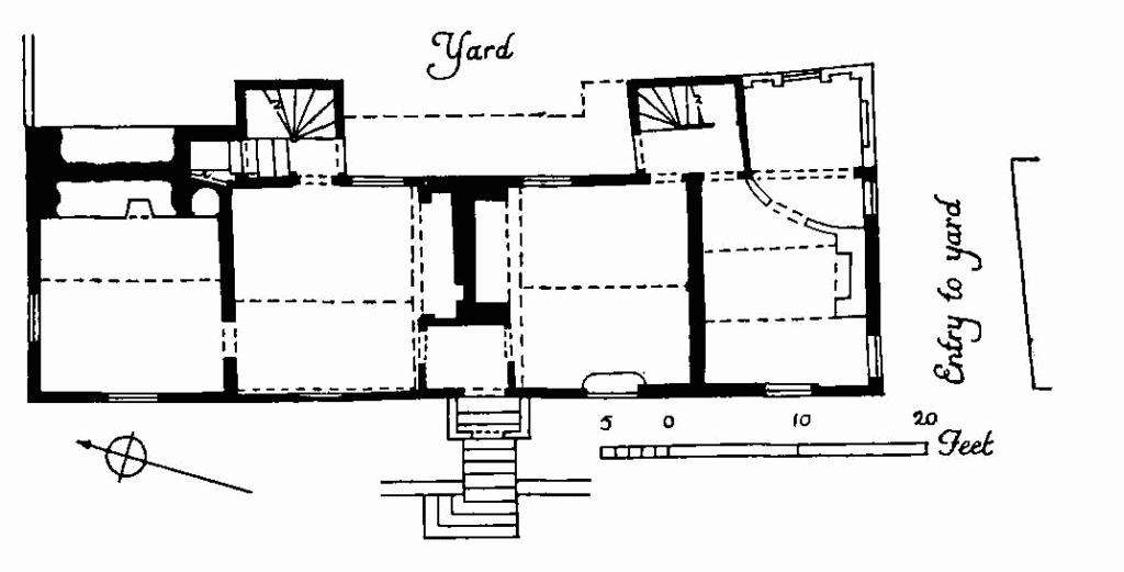
Caxton, Monument No. 6
Some structural timbers are visible internally, including a moulded beam, perhaps reused, in a cellar immediately N. of the central chimney.
S. of the house is the entry to the yard, around which are some 18th-century and later outbuildings; others have been demolished in recent years.
d(7) House (Class J), framed and plastered, with slated roof, originally of a single storey, was built in the 17th century. The side walls were heightened and a new roof of flatter pitch added to make bedrooms in the 19th century.
d(8) Caxton Manor, for a time The George Inn, consists of a house and buildings. The House, of two storeys with attics, has walls predominantly of red brick, and slated roofs. It dates from c. 1600 and consists of a gable-ended main range with a central carriage entry, facing E. across the street to the former market place, and a wing at an obtuse angle to the S.W. The house was converted to an inn apparently in the 18th century when it was refronted and the interior largely remodelled, but it reverted later to private use. There are a number of 19th-century and modern modifications: the floor of the carriage entry has been raised and its ends closed by glazed screens; a centrally placed clock turret dated 1887 now dominates the street elevation.
The Georgian E. front (Plate 59) is symmetrically designed in seven bays with the three middle bays forming a slightly recessed centrepiece. The front door is set in a modern glazed screen under an 18th-century elliptical-headed arch at the street end of the old entry. The hung-sash windows are original save for the second from the S. on the ground floor which has recently replaced a door. The wall face rises to a parapet behind which are two small hipped dormers; it is broken in the centre by the projecting and gabled clock turret. The W. side (Plate 59) is almost entirely in original dark red brick of c. 1600, rather irregular in size and bond. The principal features are two narrow tower-like gabled projections; between them is the W. arch of the carriage entry with a depressed triangular head. Above this arch is a wide original window divided into twelve equal lights by brick mullions and transoms with a somewhat defaced entablature over the head. A number of other original windows, mostly blocked or mutilated, survive; they are smaller but of similar character. These openings are all executed in cut brick, originally stuccoed to resemble stone, but much of the stucco has flaked off and has been partly replaced by modern plaster. The adjoining N.W. side of the S.W. wing is similar in character, but the gabled upper part of its S.W. end is of plastered studwork. The S.E. side is also similar but has been partially cased in modern brick or plastered over. These subsidiary elevations have a number of original mullioned windows of stucco-covered cut brick, more or less imperfectly preserved.
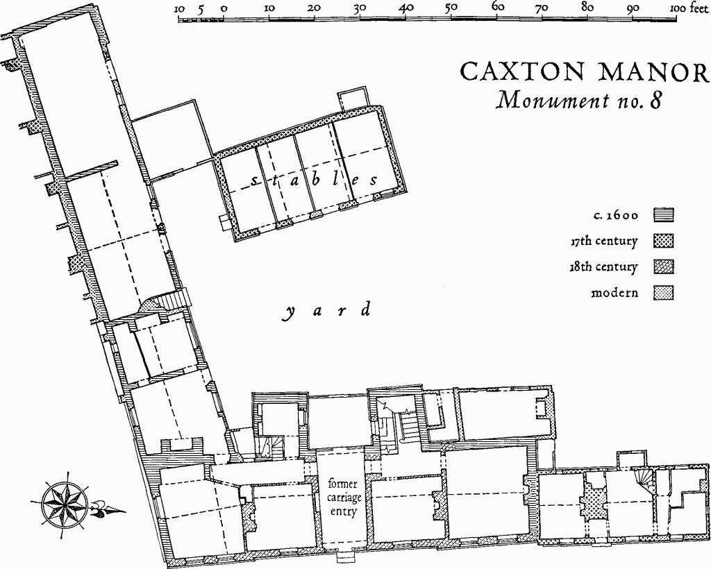
Caxton Manor, Monument No. 8
The house retains few original features inside. Some ceiling beams are stop-chamfered, and one, in a cellar immediately N. of the entry, is moulded. The principal rooms on both floors of the main range are now organised inn-fashion along N.-S. passageways running the length of the W. side. The 18th-century staircase, housed in the N. projection, ascends to the first floor in two flights; it has square newels, turned balusters, moulded rail and cut string with carved spandrels. There are two simple stone fireplace surrounds and several doors of six fielded panels, also of the 18th century.
The Buildings include a brick-built barn in prolongation of the S.W. wing and approximately coeval with it. The S.E. wall of this barn is almost entirely masked by the N.W. wall of later out-buildings in an adjoining property. Four buttresses, disposed at irregular intervals, are partly visible however. They appear to be early additions designed to arrest settlement. The entire S.E. wall, both to the house and the outbuilding, has in fact subsided continuously, perhaps as a result of having been built over a filled-in boundary ditch.
A free-standing stable block, somewhat altered, parallel to and behind the main range is also of the 17th century.
d(9) House (Class J), two-storeyed, partly of brick and partly of timber, with tiled roof, has '168 [8?]' on the chimney stack. The date may be that of a remodelling, possibly of an outbuilding of the adjoining manor house.
d(10) Smithy, of red brick with tiled roof; 18th-century, much altered.
d(11) The Crown House (Plate 64), former inn, is of two storeys with cellars and attics. The walls are partly framed and partly of red brick; the roofs are tiled. The building is Ushaped with a main range along the street and divergent wings to the W. enclosing a yard which is connected with the street by a carriage entry in its N.E. corner. The structure is of 16th- or early 17th-century origin but has undergone considerable alteration late in the 17th century and subsequently. A first-floor gallery on the S. and E. sides of the yard has been removed along most of the S. side, and has been enclosed and under-built on the E. side.

Caxton, Monument No. 11
The S. and parts of the E. and N. elevations are in red brick of the late 17th century which may replace an earlier timber frame; some original studwork survives N. of the entry and in the upper parts of the E. and N. walls. The S. side has a stepped and moulded plinth and a double band at first-floor level. The brickwork of the E. front is similar and both now have 18th-century hung-sash windows some of which have been set in earlier openings. The roofs are hipped save for the W. end of the S. wing which is gabled. Set back a little from the street front and spanning the E. end of the entry is a wooden lintel of the first half of the 17th century treated on the street side as a depressed arch with four-centred inner and square outer head and carved spandrels. At the W. end of the entry the bressummer carrying the gallery over it is carved with egg and dart ornament. The external appearance of the building from the yard has been confused by alterations and additions and by the partial destruction and enclosing of the gallery. The N. wing extends to a large brick-built outbuilding of the late 17th or 18th century, much altered, which has been a stable. Beyond it is a walled enclosure and a small pond with brick revetment.
Inside are several 17th-century brick fireplaces, for the most part elliptical-headed and placed across the corners of the rooms; one retains its original plaster, the rest have exposed brickwork and may have been stripped; the largest has a wooden lintel in place of an arch. To the N. of the entry there was until recently a small 18th-century or early 19th-century postal sorting office, but all that now survives is the wooden post box built into the N. wall of the entry. Visible features of the 17th century on the upper floor include three turned wooden posts of the gallery front; some wall painting in light red, yellow ochre and black in imitation of inlaid panelling four panels high with a frieze; and a door of six run-through panels with cocks-head hinges and carved overthrow. A short length of stair to an attic has flat pear-shaped balusters and is 17th- or 18th-century.
d(12) Home Farm, house (Class L), of red brick with tiled roofs gabled at the ends, is of two storeys with attics and cellar. The main range along the street is of three rooms with an internal chimney. The building is apparently of the 18th century, but has been altered.
d(13) House (Class I), framed and plastered, with tiled roof, is of a single storey with an attic. It is a 17th-century structure, subsequently enlarged.
d(14) House (Class L), framed and plastered, with thatched roofs, is partly of two storeys, partly of one storey with attics. It is probably of 17th-century origin, but has been much altered.
d(15) Caxton Hall (Plate 64), two storeys, brickbuilt, with hipped roofs covered with tiles, is of the second half of the 17th century with later alterations, including an annexe of one storey to the N.E. It is planned in double depth but the usual rectangular layout is broken by a short projecting wing of full height at the N.E. end of the S.E. side.
The principal elevations have a projecting plinth, platband at first-floor level, and a wooden modillioned eaves cornice. The S.W. side retains two of four original wooden windows (one of the remaining two has been blocked and the other renewed); each of these has a central light with a semicircular inner head and side lights sub-divided by transoms, all under a flat arch. On the ground floor on the N.W. side is a third original wooden window divided by short mullions into five lights. Otherwise the fenestration is of the 18th century or later.
Caxton, 'The Moats', Monument 19
Inside there is an original staircase (Plate 39), from ground floor to attics, framed around a square well. It is of solid construction, with turned balusters, square newel posts with turned finials and pendants, and moulded rail and string; it is flanked by a panelled dado from the ground to the first floor. There are also a number of 18th-century fittings, including a stone fireplace surround on the first floor with side consoles and break-front frieze carved with swags and rococo scroll-work.
a and c(16) Caxton Pastures (N.G. TL 291600) consists of a house and buildings within a moated site (see Monument (22)). The House is T-shaped, of two storeys with attics and cellar, partly brick-built and partly framed; the Buildings include a pigeon house converted to a dwelling, of brick with tiled roof; both are 18th-century.
d(17–18) Houses are framed structures with internal chimneys, of one storey with attics and tiled or thatched roofs; 17th- or 18th-century.
Earthworks
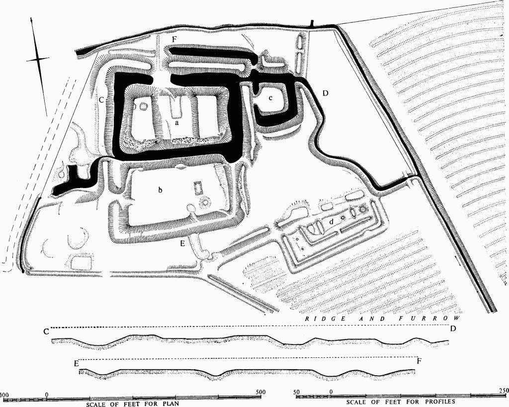
a(19) Moated Site (Class A 2 (a); N.G. TL 294587; Plates 2, 3), 'The Moats', on boulder clay ¾m. N.W. of the church, in a bend of a stream flowing S.E. to join the Bourn Brook. An old road from Caxton to Eltisley runs past the W. side of the earthworks. There are three contiguous roughly rectangular moated areas (a, b and c) and S.E. of them an unexplained block of earthworks, (d), now called the 'Asparagus Beds.'
The height of the E. and W. platforms of (a) and the strength of its ditch suggest a 'motte' rather than a moated manor house. The principal buildings of the site were probably here. (b) and (c) were probably added, (c) perhaps to protect a sluice N.E. of (a). There is no trace of the bridges needed for access.
Finds of surface pottery from (a) include Roman, St. Neots and 13th-century wares, but the moats probably originated in the 12th century as the seat of the de Scalers family (W. M. Palmer, History of Caxton (1928); Rot. Hund. (1818), II, 540–542). (d) is probably later.
(a), approximately 200 ft. by 100 ft., is surrounded by a flat-bottomed ditch 60 ft. or more wide, 6 ft. to 8 ft. deep to water which is 6 ins. to 2 ft. deep, and 15 ft. to 35 ft. across. The E. and W. platforms are about 5 ft. above the central area, being respectively 50 ft. by 100 ft. and 45 ft. by 95 ft. A rectangular depression 25 ft. by 50 ft. and 6 ins. deep runs S. to the centre. A low scarp lies S.W. of this. There is some surface disturbance, much of it modern. A counter-scarp bank outside the ditch on all but the S. side is generally 2 ft. to 3 ft. high but at the N.E. throw-out from a second ditch to the N., 30 ft. wide and 4 ft. deep, has increased the height from 5 ft. to 8 ft. The break, W. of this, and the corresponding ditch blocking are not original.
(b), approximately 220 ft. by 120 ft., is bounded by a dry V-shaped ditch 30 ft. to 50 ft. wide and 7 ft. to 8 ft. deep. The W. causeway is probably not original. The interior is flat except for a rectangular pit 3 ft. deep and a round mound, 1½ ft. high, S. of it. A counter-scarp bank on the E. is 1 ft. high.
(c), 55 ft. square with level interior, is approached by a causeway 15 ft. wide, on the W., beyond which the counter-scarp bank separates it from (a). The surrounding ditch is 25 ft. to 50 ft. wide, 4 ft. to 5 ft. deep and 15 ft. to 25 ft. wide at water level. An external bank to N. and S. is 1 ft. to 2 ft. high.
(d) is marked on the N. by a channel 30 ft. across, 2 ft. deep and 10 ft. wide across its flat bottom. The disturbed bank along its N. side is 2½ ft. high. The rectangular enclosure on its S. side is bounded by a ditch 20 ft. across, 1 ft. deep and 5 ft. across its flat bottom. The rectangle so formed appears to lie on plough ridges 6 yds. across. Immediately within the ditch is a bank 1½ ft. high. Inside this is an inner rectangle, 180 ft. by 50 ft. similarly banked but raised 6 ins. above the general ground level, in which there are four low mounds, two long and two circular. The largest of these, at the E., is 30 ft. across, 2 ft. high and about 7 ft. across its flat top. The long mounds have rounded ends projecting N. into the channel. Two further slight mounds, joined by a scarp 6 ins. high, lie between inner and outer rectangles, at the W.
Outside (a) to (d) there are slighter or less regular features, some probably recent, as perhaps are the pond and platforms W. of (b).
c(20) Mound (N.G. TL 29365849, not on O.S.); at the top of a gentle E. slope some 230 yds. S.W. of the foregoing and 175 ft. above O.D., is a low circular mound, 60 ft. to 70 ft. across and 9 ins. to 1 ft. high. It is no doubt the site of the windmill which gave the fields on either side the names 'Mill Hill' and 'Nether Mill Hill' (photostat of map of 1750 in (C.U.L.).
b(21) Moated Site (Class A2 (d); N.G. TL 305602) is that of the manor house of Swansley, which belonged to St. Neots Priory from the 11th to the 16th centuries. It is on level ground in the N.E. of the parish, 210 ft. above O.D. A rectangular area 94 ft. N. to S. and 72 ft. E. to W. is surrounded by a wet ditch 30 ft. wide and 5 ft. to 6 ft. deep to the water level, with an external bank 17 ft. wide and 9 ins. high on the S. A 19th-century brick bridge in the middle of the W. side may be in the position of the original entrance. The interior is raised 1 ft. to 1½ ft. above the surrounding ground level and is occupied by a derelict cottage and orchard. Adjacent enclosures on the N. (V.C.H., Cambs., II, 22) have been destroyed by ploughing, but 12th- to 13th-century pottery has been found on the N. and E. in areas of cobbles.
a and c(22) Moated Site (Class Al(b); N.G. TL 291600), known as 'Caxton Pastures', in the N.W. of the parish at the head of a valley running S. and just over 200 ft. above O.D. It may be that of the manor house of Brockholt which was separated from the main manor of Caxton from 1154 to 1400 (W. M. Palmer, History of Caxton (1928)).
The moat measures 427 ft. N. by 468 ft. E. by 423 ft. S. by 512 ft. W., with a wet ditch 20 ft. to 30 ft. wide and 4 ft. to 5 ft. deep to the water level. There is an external bank 17 ft. to 20 ft. wide and 1 ft. to 3 ft. high on the S. and S.E. Six causeways cross the ditch, but it is uncertain whether any is original; the S. one, in the most likely position, is approached by a track which overrides the inner bank. The interior, occupied by a farmhouse (Monument (16)) and buildings, has been disturbed.
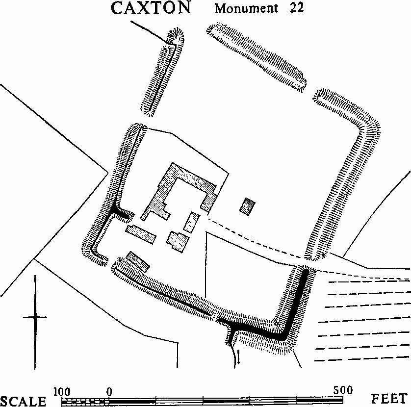
Caxton, Monument 22
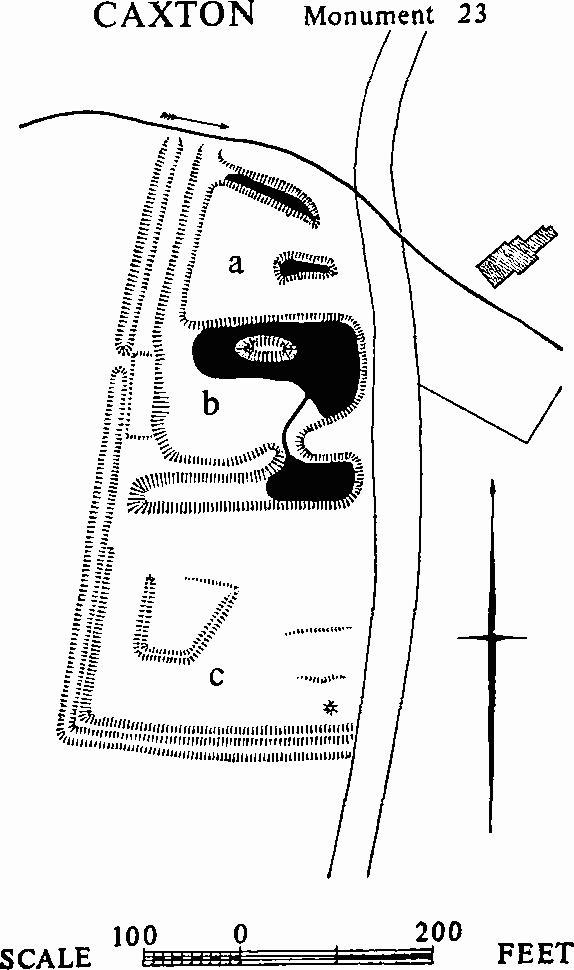
c and d(23) Moated Site (Class A3; N.G. TL 300582), claimed as that of the manor house of the manor of Colne (W. M. Palmer, History of Caxton (1928)). The remains lie on the S. side of the Bourn Brook to the W. of Peter Street alternatively known as 'Rosemary Green Road', (see photostat of map of 1750 in C.U.L.) and 50 yds. W. of Caxton Hall (Monument (15)); they consist of (a) a small moat, (b) two ponds, and (c) an enclosure ((a) and (c) are not on O.S.). The moat is probably a defensive one of the middle ages to which a later house and garden have been added, the whole being then bounded by banks and a ditch. The entire complex had already gone out of use by 1750.
Caxton, Monument 23
(a) the moat, at the N. end, is trapezoidal, measuring 112 ft. N. by 80 ft. to 90 ft. E. by 154 ft. S. by 141 ft. W., with a partly wet ditch 25 ft. wide, 4 ft. to 5½ ft. deep and 8 ft. to 13 ft. wide across the bottom. The S. side has been altered, and on the E. a pond, dug into the E. end of the interior, has destroyed everything except the suggestion of a return at the end of the N. side. W. of the moat is an outer bank 12 ft. wide and 2 ft. high, with a ditch beyond, 18 ft. wide and 1½ ft. deep, which ranges with the W. side of (c).
(b) the ponds, lie to the S. of (a). The first pond has been formed by widening the S. ditch of (a); it is roughly rectangular, measuring 220 ft. E. to W. by 150 ft. N. to S. and 2 ft. to 3 ft. deep, and is still partly wet. An oval island lies in the N. half. A second, smaller, pond adjoined it on the S. On the W. side of the first pond is a rectangular platform which carried a building in 1750 (photostat of map of 1750 in C.U.L.).
(c) a rectangular enclosure measuring 250 ft. N. by 244 ft. E. by 288 ft. S. by 218 ft. W., bounded on the W. and S. by a bank 16 ft. wide and 1 ft. high with a dry outer ditch 20 ft. wide, 3 ft. deep and 7 ft. across the bottom. The E. side of the enclosure follows the line of Peter Street and the N. side is a scarp 6 ft. high falling to the ponds. The interior slopes gently to the N. and features a trapezoidal platform, which is bounded on the N. by a scarp 1½ ft. high, and on the other sides by a bank 12 ft. to 15 ft. wide and 6 ins. high with a very slight ditch outside it.
c and d(24) Village Remains (around N.G. TL 303577; hollow-way (a) only on O.S.). The area between the church and Ermine Street, flat on the S. and sloping on the N. gently N.E. to the Bourn Brook, is crossed by two hollow-ways, (a) and (b), with closes in between, perhaps marking the site of the village prior to the migration on to Ermine Street.
(a) runs E. from a road junction (N.G. TL 30135784) N.E. of the church to Ermine Street and for 500 ft. beyond; it must have continued to Caxton End in Bourn. W. of the main road it is 25 ft. to 40 ft. wide and up to 3 ft. deep; the continuation E. takes the form of a rutted track 20 ft. wide.
(b) runs parallel and to the S. of (a) from a point (N.G. TL 30035773) S. of the church for 440 yds. before turning N.E. to meet (a). It is 30 ft. to 50 ft. wide and 6 ft. deep, flatbottomed, in parts boggy and overgrown throughout. The length running N.E. is 534 ft. long, 20 ft. to 25 ft. wide and 3½ ft. deep. At 100 ft. from the beginning of the hollow-way a ramp 12 ft. wide leads out of its S. side into a field with remains of ridge and furrow.
Between the above hollow-ways are three curving closes, divided by banks 2 ft. wide and 9 ins. to 1 ft. high; N. of (a) are seven further closes. These existed in 1750 and are covered by ridge and furrow, with no trace of house sites. Some buildings which then stood W. of Peter Street have been destroyed; a disturbed area of hollows and scarps around N.G. TL 300583 marks their site.
A third road, now disused and in part occupied by the Bourn Brook, seems to have run N.W. from N.G. TL 30405815 at least as far as 29905844.
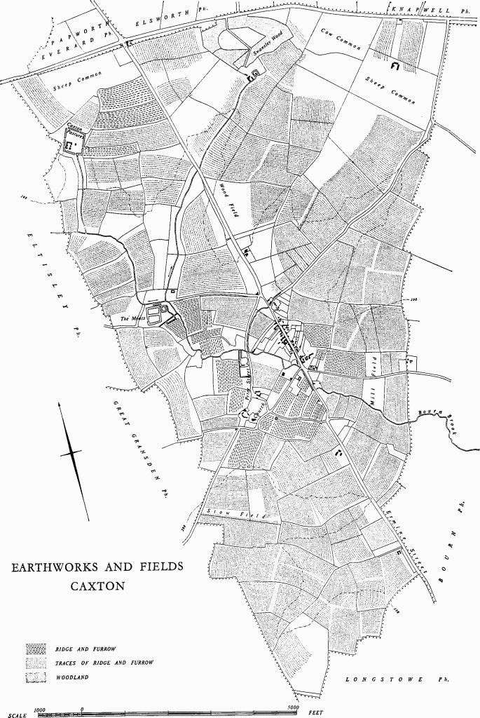
Earthworks and Fields, Caxton
(25) Cultivation Remains (not on O.S.) consist of ridge and furrow in old enclosures. Ridge and furrow with ridges 60 yds. to 200 yds. long, 6 yds. to 11 yds. wide, and 6 ins. high, with headlands of 5 yds. to 11 yds., is preserved on the W. and S.W. of the village in old enclosures. The N.W. part of the parish, W. of Ermine Street, also has remains and traces in old enclosures; here ridge and furrow is from 70 yds. to 500 yds. long, 6 yds. to 9 yds. wide, with headlands 7 yds. to 9 yds. wide. This outlying area was enclosed before 1750, the existing field pattern indicating that this was done by furlongs from former open fields; the great length of some of the ridges suggests that, in a late phase, some end-on furlongs were ploughed as one.
Over the remainder of the parish air photographs show traces of ridge and furrow in 'Mill', 'Stow' and 'Wood' Fields, enclosed in 1834. Notable exceptions are the former Sheep and Cow Commons in the extreme N. (See map: 'Earthworks and Fields').
(Ref: photostat of map, 1750 (C.U.L.); enclosure map 1834 (C.R.O.); W. M. Palmer, History of Caxton (1928); air photographs: 106G/UK/1490/3018, 3233–6, 4186–8.)