An Inventory of the Historical Monuments in Dorset, Volume 1, West. Originally published by Her Majesty's Stationery Office, London, 1952.
This free content was digitised by double rekeying. All rights reserved.
'Shipton Gorge', in An Inventory of the Historical Monuments in Dorset, Volume 1, West, (London, 1952) pp. 221-223. British History Online https://www.british-history.ac.uk/rchme/dorset/vol1/pp221-223 [accessed 24 April 2024]
In this section
82 SHIPTON GORGE (C.e.)
(O.S. 6 in. XXXVIII, S.E.)
Shipton Gorge is a parish and village 3 m. E. of Bridport.
Ecclesiastical
(1) Parish Church of St. Martin, formerly a chapel of Burton Bradstock, stands on the S. side of the village. The walls of the tower are of local rubble with dressings of the same material. The West Tower was built c. 1400 but the rest of the church was entirely rebuilt in 1862.
Architectural Description—The West Tower (10 ft. by 9 ft.) is of two stages with an embattled parapet and gargoyles; there is a stair-turret on the S. side. The tower-arch is modern. The W. doorway has chamfered jambs and triangular arch in a square head with blank shields and cleavers with enriched blades in the spandrels; the restored W. window is of three trefoiled lights with vertical tracery in a two-centred head. The bell-chamber has, in the E. and N. walls, a loop-light; in the W. wall is a window of two trefoiled lights with a quatrefoil in a two-centred head.
Fittings—Bells: four; 3rd by Thomas Purdue, 1655, perhaps recast. Font: heptagonal bowl with three trefoil-headed panels in each face, splayed and cylindrical stem and plain base, 13th-century. Painting: In vestry—of David, painted on boards in moulded frame, 18th or 19th-century. Plate: includes a shallow Elizabethan cup (Plate 28) with a band of engraved ornament and a cover-paten of the same date.
Secular
(2) Innsacre Farm, house 1,130 yards N.N.W. of the church, is of two storeys; the walls are of rubble and the roofs are slate-covered. It was built early in the 17th century but the S.E. part of the house seems to have been added or rebuilt late in the same century and the porch is of the later date. The front has stonemullioned windows, those to the ground-floor with labels; the outer doorway of the porch has a four-centred head; the inner doorway has a square head. S.E. of the porch is an early 18th-century niche with a round shell-head. There are two 17th-century stone windows in the S.E. end. Inside the building one room has an open timbered ceiling and an original fireplace; in the wall beside the fireplace is some timber-construction of uncertain use.
Monuments (3–10)
The following monuments, unless otherwise described, are of early 18th-century date and of two storeys; the walls are of rubble and the roofs are thatched or covered with modern materials. Some of the buildings have exposed ceiling-beams and original fireplaces.
(3) Cottage, on the E. side of the road, ¼ m. N.W. of the church, was built in the 17th century.
(4) Cottage, on the S.W. side of the road, 200 yards N.W. of the church, was built in the 17th century and retains two original stone-mullioned windows with labels.
(5) Cottage, two tenements, on the N. side of the road 100 yards E.S.E. of (4).
(6) Cottage, 70 yards N.E. of the church.
(7) Home Farm, house 70 yards E. of (6).
(8) Cottage, on the N. side of the road, 80 yards E. of (7).
(9) House, 1,230 yards E.N.E. of the church.
(10) Broad Sturthill Farm, house 1½ m. E.N.E. of the church, has a 17th-century E. wing; the rest of the house is modern. The old wing retains some original stone-mullioned windows.
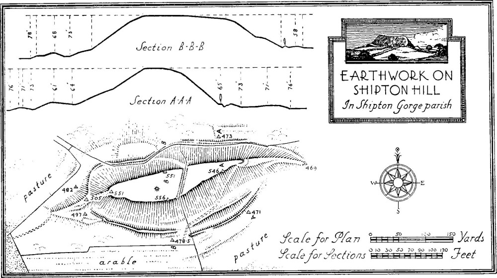
Earthwork on Shipton Hill in Shipton Gorge parish
Earthworks
(11) Earthwork on Shipton Hill (565 ft. above O.D.), ¾ m. N.E. of the church, forms an enclosure of about ¾ acre. The hill-top has been artificially steepened on the N. and S. sides and the two ends form natural ramped causeways leading up to the summit. At the base of the hill on both the N. and S. sides is a ditch with outer rampart of no great strength, and at the present time, for part of their length, both have almost disappeared. Both the ditch and rampart stop short of the E. and W. ends of the hill.
Between the base of the mound and the outer ditch at the eastern half of the S. side is a berm, but it seems probable that it is merely a natural outcrop of rock. The two pathways leading up the slope on the N. and S. are probably modern. On the top of the enclosure near the middle is a cross hedge-bank which appears to have been formed along the eastern scarp of a ditch to an earlier bank, traces of which can be seen immediately E. of the existing hedge-bank. Near the middle of the enclosure is a circular mound, of about 28 ft. diameter and 14 in. high.
Beyond the rampart on the N. side, and to a much lesser degree on the S. also, are a series of rough terraces. They would seem to be a natural formation though their surfaces in one or two places show signs of disturbance. Warne mentions the disturbed nature of the N.E. part of the field immediately to the N.E. of this camp and suggests the possibility of its being a Celtic village. This disturbance is still visible but is quite indeterminate.
(12) Mound, probably a bowl barrow, on Hammiton Hill, ¾ m. E. of the church, is about 86 ft. by 76 ft. across and 5½ ft. high.
(13) Lynchets, on the S. slope of Bonscombe Hill, 1,200 yards N.W. of the church, form four terraces, from 25 ft. to 40 ft. wide.
South Perrott, see Perrott, South.