An Inventory of the Historical Monuments in Dorset, Volume 1, West. Originally published by Her Majesty's Stationery Office, London, 1952.
This free content was digitised by double rekeying. All rights reserved.
'Bradford Peverell', in An Inventory of the Historical Monuments in Dorset, Volume 1, West, (London, 1952) pp. 34-36. British History Online https://www.british-history.ac.uk/rchme/dorset/vol1/pp34-36 [accessed 25 April 2024]
In this section
10 BRADFORD PEVERELL (E.d.)
(O.S. 6 in. (a)XL, N.W. (b)XL, S.W.)
Bradford Peverell is a parish adjoining that of Dorchester on the N.W. Amongst the numerous mounds and barrows are three long barrows (9, 12b and 15e) and a bank barrow (12a).
Roman
b(1) Aqueduct, formerly supplying the Roman town of Dorchester, passes through this parish. It will be described in Volume II, under Dorchester.
Ecclesiastical
b(2) Parish Church of St. Mary stands in the village. The walls are of coarse ashlar with ashlar dressings and the roofs are covered with tiles. It was entirely rebuilt in 1850 to the designs of Decimus Burton in 13th-14th-century style, and consists of Chancel, N. Vestry, Nave, W. Tower with broach-spire and S. Porch. It retains from the older church the following:—
Fittings—Bells: five; 4th by Thomas Purdue, 1674. Glass: In chancel—in E. window, figures and borders of 13th-century character, nearly all modern but incorporating fragments of various dates; in N. window, four panels (Plate 17), the upper pair with a Coronation of the Virgin and the lower pair an Annunciation (St. Gabriel modern), grisaille background and crown in tracery, 15th-century made up with modern work. In nave—in N.W. window, shield-of-arms of William of Wykeham with mitre and garter, scrolls with the motto "Manare makythe man" and the name William Wykkam, 16th-century, presumably from New College. Monuments and Floor-slabs. Monuments: In W. tower —(1) to Rev. Middleton Onslow, 1837, white marble sarcophagus-shaped wall-tablet with urn, by Lester, Dorchester. In churchyard—S. of chancel, (2) to John Richards, 1696, headstone; (3) to Luke Dearing, late 17th-century, table-tomb; (4) to Ann, wife of Luke De[aring], 1694, table-tomb; S. of nave, (5) to Mary, daughter of Edward Genge, 1695, headstone; S. of porch, (6) to Elias Harris, 168., headstone; (7) to Mary Harris, 1684, headstone. Floor-slabs: In nave —(1) to John Jobbins, 1696; (2) to Thomas Megg[s], 1698–9, and others later; (3) to Thomas Meggs, 1696; (4) to Harry Meggs, 1702, and others later; (5) to Harry Meggs, 1782. Plate: includes a set of two cups, a paten and a flagon presented in 1813. Royal Arms: Over tower arch, of wood, of Victoria. Seating: In tower, two stools with turned legs, 17th century. Table: In tower, with moulded top, turned legs and stretchers, late 17th-century with modern repairs.
Secular
b(3) Manor Farm, house 50 yards S.S.E. of the church, has been entirely rebuilt, but incorporates an early 17th-century doorway with moulded jambs and four-centred arch in a square head; there are also fragments of 15th-century cusped panelling and cusped arched heads, and portions of a moulded lintel and a shaft or mullion.
Monuments (4–7)
The following monuments, unless otherwise described, are of the 17th century and of two storeys; the walls are of rubble and the roofs are thatched. Some of the buildings have exposed ceiling-beams.
b(4) Cottage, on the N.E. side of the road 140 yards E. of the church, has been much altered.
a(5) Muckleford Dairy House, on the S. side of the road nearly 1¼ m. W.N.W. of the church, is partly built of cob-walling. There is one original window of four lights with an oak frame. In the attic at the E. end is a plaster panel with conventional foliage-decoration with the initials and date E. and A.S. (for Sheridan), 1655 M.S.
a(6) Cottage, on the N. side of the road 120 yards W.N.W. of (5), was built c. 1700.
b(7) Whitfield Farm, house over 1¼ m. S.E. of the church, has a small wing on the E.
Earthworks
b(8) Bowl Barrow, on the W. border of the parish nearly 1½ m. W.S.W. of the church, is 60 ft. in diam. and 2 ft. high.
b(9) Long Barrow, 220 yards N.E. of (8), is about 120 ft. long (347° mag.); the greatest width, towards the S.S.E., is 58 ft. where the height is 3 ft. There are no remains of ditches. (O.S. Map of Neolithic Wessex, No. 152.)
b(10) Bowl Barrows, two, E. of Red Barn and 770 yards E. of (8). The more northerly is 60 ft. in diam. and 3 ft. high. The second, 25 yards to the S.E., is 34 ft. in diam. and 1½ ft. high.
b(11) Mounds, probably bowl barrows, on a spur N.W. of Penn Hill and ¾ m. W. of the church, are three in number. The northernmost (a) is 56 ft. in diam. and ½ ft. high; the second (b), 30 yards to the S.E., is 58 ft. in diam. and ¾ ft. high; the third (c), 70 yards S. of (a), is 50 ft. in diam. and ¾ ft. high.
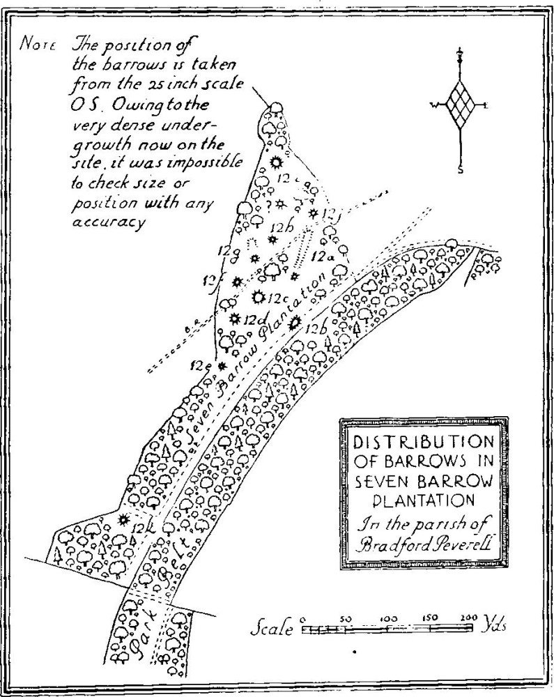
Distribution of Barrows in Seven Barrow Plantation
b(12) Barrows and Mounds in Seven Barrow Plantation, about ¾ m. S.W. of the church, are twelve in number, much overgrown. (a) a long barrow or small bank barrow (about 30° mag.), near the N.E. corner of the plantation, is about 210 ft. long by 37 ft. wide and 3¾ ft. high, with traces of a ditch on each side; at its southern extremity is a mound, probably a bowl barrow, about 50 ft. in diam. and 3½ ft. high; (b) mound, 45 yards S. of (a), probably a small long-barrow, is about 87 ft. long and a maximum of 44 ft. wide towards the N.E. end; the height varies from 5 to 3½ ft.; (c) mound, 45 yards S.W. of (a), is of oval form 23 by 30 ft. and 2 ft. high; (d) bowl barrow, 35 yards S.W. of (c), is 68 ft. in diam. and 5 ft. high with remains of a ditch; (e) bowl barrow, 55 yards S.S.W. of (d), is 29 ft. in diam. and 2½ ft. high; (f) bowl barrow, 120 yards W. of the S. end of (a), is 63 ft. in diam. and 6 ft. high, with a ditch; the middle has been disturbed; (g) mound, 35 yards N.E. of (f), is now entirely overgrown; (h) mound, probably a bowl barrow, 60 yards N.E. of (f), is about 60 ft. in diam. and 4 ft. high; (i) mound, possibly a bowl barrow, 95 yards N. of (h), is about 55 ft. in diam. and 4 to 5 ft. high; (j) bowl barrow, 25 yards N. of the N. end of (a), is 50 ft. in diam. and 5 ft. high; (k) bowl barrow, 340 yards S.S.W. of (a), is 55 ft. in diam. and 4½ ft. high.
b(13) Bowl Barrow, W. of Higher Skippet Farm and nearly 1¾ m. S.W. of the church, is 42 ft. in diam. and 2½ ft. high.
b(14) Barrows and Mound, on Bradford Down about 1½ m. S.S.W. of the church, are three in number. The most southerly (a), bowl barrow, is 34 ft. in diam. and 1½ ft. high; it has been disturbed in the middle; (b) bowl barrow, 385 yards N.N.E. of (a), is 55 ft. in diam. and 5 ft. high; (c) possibly a barrow, 230 yards E. of (b), is of oval form and about ¾ ft. high.
b(15) Barrows, to the N. and E. of Forty Acre Plantation 1 m. S.E. of the church, are eight in number; some of them were opened by E. Cunnington 1879–87 (Dor. N.H. and Ant. F.C. xxxvii, p. 41). The most westerly (a), perhaps a bell barrow, is actually in Highfield Plantation; it is 45 ft. in diam. with a surrounding raised berm making the diam. 63 ft.; it is 5 ft. high. This is Cunnington's No. 14 and was opened in 1887 and contained a burnt burial with ashes at a lower level. The remainder, with the exception of (e), are probably bowl barrows. (b), 125 yards E.N.E. of (a), is about 75 ft. in diam. and 1½ ft. high; it is presumably Cunnington's No. 13, was opened in 1880 and contained ashes. (c), 70 yards N.E. of (b), is 85 ft. in diam. and 2 ft. high; it is presumably Cunnington's No. 12, was opened in 1880 and contained a skeleton, and a beaker and fragments of a second beaker now in the Dorset County Museum. (d), 290 yards E.N.E. of (c) and just N.E. of the road, is 81 ft. in diam. and 1 ft. high. (e) long-barrow (322° mag.), 30 yards N.E. of (d), is about 156 ft. long by 89 ft. at its widest point (40 ft. from the S.E. end); here it is 4 ft. high. (O.S. Map of Neolithic Wessex, No. 153.) It is Cunnington's No. 11, and was trenched by him in 1881, when human remains were found (Dor. N.H. and Ant. F.C. xxxvii, 42, No. 11). (f), 100 yards S.E. of (e), is about 100 ft. in diam. and 3 ft. high. It is presumably Cunnington's No. 10, opened in 1881 and contained a contracted burial, a handled food-vessel and flint implements; at a higher level was a skeleton and a fragment of Samian. (g), 50 yards N.E. of (f), is 85 ft. in diam. and 1½ft. high. (h), 290 yards E.S.E. of (g), is 90 ft. in diam. and 4 ft. high. It is Cunnington's No. 9, was opened in 1879 and contained a skeleton in a large oval grave, with a bronze dagger; there were other burials, worked flints, etc.
b(16) Bowl Barrow, ¼ m. W. of (7), is 54 ft. in diam. and 11 ft. high. This mound was opened by E. Cunnington in 1879 and found to contain a contracted skeleton below ground level, other burnt remains, a beaker, potsherds and a small bronze dagger. A coin of Tetricus was found on the surface (Dor. N.H. and Ant. F.C. xxxvii, 41, No. 8).