An Inventory of the Historical Monuments in Dorset, Volume 2, South east. Originally published by Her Majesty's Stationery Office, London, 1970.
This free content was digitised by double rekeying. All rights reserved.
'Kimmeridge', in An Inventory of the Historical Monuments in Dorset, Volume 2, South east(London, 1970), British History Online https://www.british-history.ac.uk/rchme/dorset/vol2/pp132-135 [accessed 30 April 2025].
'Kimmeridge', in An Inventory of the Historical Monuments in Dorset, Volume 2, South east(London, 1970), British History Online, accessed April 30, 2025, https://www.british-history.ac.uk/rchme/dorset/vol2/pp132-135.
"Kimmeridge". An Inventory of the Historical Monuments in Dorset, Volume 2, South east. (London, 1970), British History Online. Web. 30 April 2025. https://www.british-history.ac.uk/rchme/dorset/vol2/pp132-135.
In this section
15 KIMMERIDGE (9179)
(O.S. 6 ins. SY 97 NW)
Kimmeridge is a small roughly rectangular coastal parish covering just under 1,000 acres, lying almost entirely on Kimmeridge Clay, and sloping steeply south-westward from the limestone crest of Smedmore Hill at over 600 ft. above O.D.
There were three mediaeval settlements in the parish, Kimmeridge, Smedmore and Little Kimmeridge, each associated with a rectangular block of land stretching from the sea to Smedmore Hill; their boundaries are still preserved as continuous hedge-lines. Only Kimmeridge village at the N. end of the parish remains as a sizable settlement, but strip fields (Monument 15) of all three settlements remain. The village is grouped round a street running S. from the church and comprises small houses and cottages of the 17th and 18th centuries.
The parish is remarkable for the layers of bituminous shale contained in the Kimmeridge Clay. The richest, known as 'blackstone', was used in prehistoric and Roman times for the manufacture of ornaments and other objects, the circular pieces of 'coal-money' being the waste from turned armlets of Iron Age 'C' and Roman date; numerous working sites are known. In the 17th century Sir William Clavell proposed to extract alum from the blackstone and also use it, as the Romans had done, as fuel for boiling sea-water to extract salt.
These enterprises, and plans for the manufacture of glass, using blackstone for fuel, came to nothing. In the 19th century oil was, for a time, extracted from the shale, and an Act of 1847 gave powers to construct 'railways, . . . inclined planes, cause-ways etc.' (D. Maxwell, Unknown Dorset (1927), 20); it was probably under these powers that a tramway was laid right down to the pier from the workings to the E.
Smedmore House (Monument 4) is the principal monument.
Ecclesiastical
(1) The Parish Church (dedication unknown) stands at the N. end of the village. The walls are of stone rubble with ashlar dressings and the roofs are covered with stone slates. The chancel and nave are structurally undivided; the Nave is of 12th-century origin and retains the original S. doorway. There was formerly a 13th-century chancel arch, the moulded voussoirs of which remain loose in the churchyard, but the Chancel and the whole of the N. wall and part of the S. wall of the nave have been rebuilt at various dates since the Reformation. In the 15th century a bell-cote and a buttress were added to the W. wall. The South Porch is of early 13th-century origin. Extensive rebuilding took place in 1872, and the Vestry is modern.
Architectural Description—The Chancel and Nave form a simple rectangular building (56 ft. by 16 ft.) with a bell-cote over the W. gable. The E. and S. windows are of the late 19th century. The S. doorway has roll-moulded jambs, a semi-circular-arched head of a single roll-moulded order, moulded imposts and a chamfered label. At the S.W. corner is the base of a destroyed buttress. The W. windows are single two-centred lights of the early 19th century arranged in two tiers to accommodate a former W. gallery. The W. buttress is of two weathered stages with a moulded plinth. The bell-cote has an arched opening with four-centred head, but all the upper part is rebuilt. The South Porch (8 ft. by 4½ ft.) has an outer archway with two-centred head of two chamfered orders and continuous jambs.
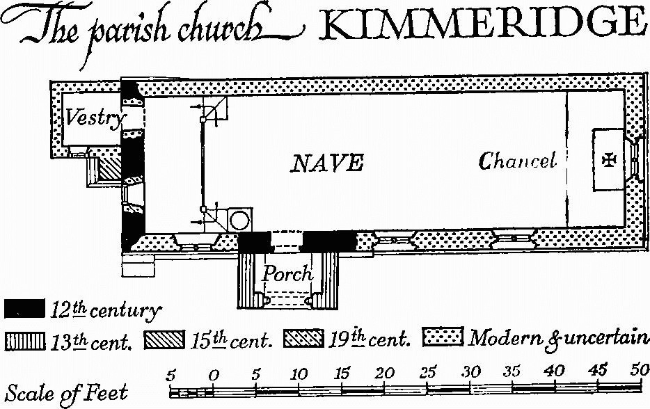
The Parish Church, Kimmeridge
Fittings—Bell: one, inscribed 'ave g[racia plena]', 15th-century. Brass: in nave, in floor, of Richard Clavell, 1637/8, small inscription plate. Coffin-lids: in churchyard—S.E. of chancel, (1) tapered and hollow-chamfered slab with traces of an eight-armed cross, 13th-century; S. of chancel, (2) tapered and moulded slab with traces of a cross on a Calvary, 15th-century; E. of S. porch, (3) tapered slab with plain top, of uncertain date. Communion Table: with turned legs, fluted bearers and plain stretchers, early 17th-century, with modern top. Font: rough circular stone bowl, probably 12th-century, set on modern stem and base. Inscriptions and Scratchings: on E. jamb of S. doorway, initials, probably c. 1600. Monuments and Floor-slabs. Monuments: in chancel—on N. wall, (1) to William Clavell, 1817, erected by his widow Sophia (Bingham) and his brother, white marble tablet with cornice, urn and shield-of-arms against a grey background; in nave—on S. wall, (2) to Sophia (Bingham), widow of William Clavell, 1841, white marble tablet with cornice against a black background, signed Tyley, Bristol; in churchyard—loose against vestry, (3) to George Foot, 1693, headstone. Floor-slab: in chancel—to Frances Swaine, daughter of Roger Clavill, 1701. Painting: over S. doorway, on rear arch, painted scroll-work border, possibly 16th-century. Plate: cup, 1825, and paten, 1824. Miscellanea: loose in churchyard, mediaeval moulded stones including parts of a 13th-century chancel arch and fragments from 15th-century windows.
Secular
(2) 'Clavel Tower' (909786), 'folly' (Plate 58), of three storeys above a semi-basement, is of brick and rubble covered with stucco and with ashlar dressings. It was built by the Rev. John Richards, who assumed the name of Clavell on inheriting Smedmore in 1817 and died in 1833 (Hutchins I, 571).
The tower is circular; the first stage is surrounded by a colonnade for which the basement forms a projecting podium; the upper stages are divided by a moulded string-course, and at the top is a cornice with mock machicolation and a parapet pierced with quatrefoils. The door and window openings are round-headed.
(3) Pier, Sea Wall, etc., on the E. side of Kimmeridge Bay (908787), were built probably by Sir William Clavell in the early 17th century, in connection with mineral working.
The Pier, built of large blocks of squared stone, laid dry, is approximately 75 yds. long and 26 ft. wide at the base of sloping sides; extending N.E. from the pier are the tumbled remains of a Sea wall of similar construction.
Tramway, behind Hen Cliff (909787–912782), survives as an embankment, cuttings and terracing. It is 4 ft. to 6 ft. wide and runs for 1,900 ft. from the cliff edge above Yellow Ledge down a carefully made gradient of about 1 in 40 to a terraced platform, about 110 ft. by 15 ft., on the top of the cliff above the pier. It is not known whether this tramway is also the work of Sir William Clavell.
In the 19th century a further Tramway, nearly a mile long, was laid from workings at 916782 and 915787 down to the shore to just N. of the earlier structures, where a timber pier, now destroyed, projected from a length of sea wall; this last survives in fair condition. The tramway is shown on the 1930 edition of the 6 ins. O.S. map (sheet LV S.E.).
(4) Smedmore House (924788), of two storeys with attics and a small cellar, has walls of local stone and roofs covered with stone slates. It was built by Sir William Clavell early in the 17th century but the form of the original house cannot now be determined. In the early 18th century the house was entirely remodelled with a new and sophisticated S.W. elevation; in 1761 a new range comprising entrance hall and reception rooms was built across the N.W. end of the old house, involving the destruction of part of the early 18th-century S.W. elevation which had presumably been symmetrical. An estimate for the completion of the work survives in the house. Also in the second half of the 18th century a kitchen wing was built to the E. This was extended to the N.E. towards the end of the century and widened to the N.W. later. The S.E. wing was added c. 1800.
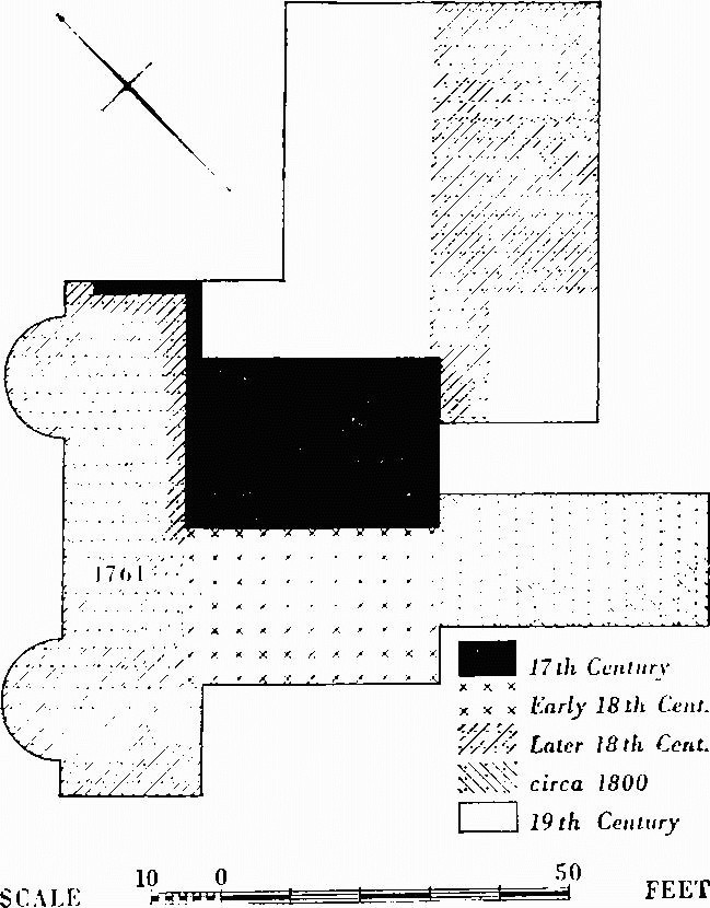
Smedmore House, Plan
The elevations of the early 18th century and of 1761 are both of high-class workmanship and make an interesting contrast. The interior retains some good 18th-century fittings.
Architectural Description—The main front (Plate 99) to the N.W. is faced with Portland ashlar under a simplified modillion cornice and parapet; it is symmetrical. The central doorway with flanking engaged Ionic columns and pediment is flanked by hung-sash windows, with plain architraves and keystones, which are repeated on the first floor. To each side is a projecting semicircular bay with similar windows. The ashlar facing returns some 3 ft. along the N.E. gable end, the rest of which is of 17th-century rubble with the remains of an original mullioned window, now blocked.
The S.W. elevation comprises the gabled end of the N.W. range, mostly of stone rubble and without openings, the principal elevation of the centre block and the side of the S.E. wing. The centre block (Plate 98), of Purbeck stone rubble with Portland dressings, has a moulded cornice and ashlar parapet. Over the doorway is a hood carried on console brackets and linked by panels to the scrolled and finely carved surround which encloses the architrave of the window above. The ground and first-floor windows have bolection-moulded architraves and are linked vertically by ashlar panels. Similar windows are reset in the S.E. elevation of the projecting part of the N.W. range. The openings on the S.E. return of the centre block have later architraves with keystones. The S.E. wing is also of stone rubble with cornice and ashlar parapet and has on each floor four windows with simple moulded architraves, of which three are modern. The S.E. end is gabled and has a reset 18th-century doorway. The N.E. elevation of the wing is built in the traditional style, with overhanging eaves and two-light stone-mullioned windows, those on the ground floor having transoms.
Lead rainwater heads of 1761 are embossed with the Clavell crest, a buck's head pierced by an arrow.
The kitchen wing projects to the N.E. and is of one storey only and, with the later extension to the N.E., is covered by three parallel roofs with half-hips to the S.E.; under the middle hip is a Palladian window and to each side a window with plain architrave under a pointed arch.
In the N.W. range the central Entrance Hall has the walls decorated with dado rail, plaster panels and enriched modillion cornice; on the S.E. wall are two console brackets with sprays of foliage; over the doors are moulded cornices. The Dining Room to the N.E. has dado rail, plaster panels and cornice, all enriched, and the principal panels are scrolled at the top and decorated with floral swags below. The fireplace has a surround in white and coloured marbles. Leading out of this room is a 17th-century doorway with chamfered four-centred head. The Drawing Room to the S.W. has an enriched dado rail and cornice; the marble fireplace has side pilasters with acanthus decoration and a frieze panel carved with a pastoral scene (Plate 54). In the central block the Cedar Room is lined with bolection-moulded panelling. The Study has a bolection-moulded Purbeck marble surround to the fireplace. The Staircase is of the early 18th century with balusters alternately turned and partly twisted. In the Pantry is a stone archway, moulded on both sides, of the early 17th century, reused. In the kitchen wing the Old Kitchen has a plaster barrel ceiling and a large fireplace with three-centred head between flanking arches. On the first floor a small room in the N.W. range has a fireplace with an elaborate rococo surround of c. 1760 and an iron grate decorated with figures in medallions (Plate 56).
The Brewhouse, to S.E., is of 17th-century origin, remodelled in the early 19th century; it has an original doorway with moulded four-centred head and a four-light window with stone mullions. The Stable Building, of the early 18th century, is U-shaped on plan and has a central rusticated archway under a pediment.
(5) The Old Parsonage (20 yds. E.), of two storeys with stone walls and stone-slated roofs, was built in 1837 in the Jacobean style with stone-mullioned windows.
(6) Kimmeridge Farm (immediately W.) is of two storeys with stone walls and stone-slated roofs. It was remodelled and enlarged to its present form early in the 19th century and the back wing bears a date stone of 1829. Over the front entrance is a later shield-of-arms of Mansel.
Monuments (7–14)
The following monuments, unless otherwise described, are of one storey with attics with walls of stone rubble and thatched roofs.
(7) Post Office (110 yds. S.S.W.) is a single-storey cottage probably of the late 18th century. Inside is a plaster barrel-vaulted ceiling.
(8) Cottages, Nos. 25–30, 15 yds. E. of (7): Nos. 29 and 30 were built as one house in the 17th century on a two-room plan with a central chimney. Early in the 19th century the house was divided and Nos. 25–28 were built, each with a living room, scullery and detached outhouse, and another cottage with tiled roof was added to the N.
(9) Cottage (160 yds. S.S.W.) is dated 1848.
(10) House and Cottage (220 yds. S.S.W.) were built probably in the 17th century as a single house on a two-room plan with a central through passage. Extensions were made to the two ends in the 18th and 19th centuries.
(11) Cottage, now two tenements (220 yds. S.), was built in the 18th century as one dwelling with a central entrance. An addition with a slated roof is probably of the 19th century.
(12) Cottages (330 yds. S.S.W.) comprise a small early 17th-century house built on a two-room plan with end entrance, a through passage and third room both added in the 18th century and later additions.
(13) Cottages (390 yds. S.) are probably of the 18th century.
(14) Kimmeridge Dairy (920786) is of one and two storeys and has roofs covered with stone slates and tiles. It was built in the 18th century on a two-room plan with central entrance and end chimneys, and later lengthened. Abutting the S.W. end of the house is an 18th-century Barn nearly 90 ft. long.
Earthworks, Etc.
Mediaeval and Later Earthworks
(15) Strip Lynchets, of marked up-and-down form, occur in four isolated groups on the S. face of Smedmore Hill. All are in pasture and nearly all run across the contours, some as steeply as 20° but in places easing to 5° before termination. Treads are 5 yds. to 23 yds. wide with risers to the up-anddown lynchets in some instances as much as 5 ft. high. The strips around 920798 belonged to Kimmeridge village itself, the two groups at 925794 and 927793 to the former settlement of Smedmore (now Smedmore House) and those at 930787, cut by bench quarrying, to the former hamlet of Little Kimmeridge. A roughly-shaped stone (92417941), 5 ft. long and parallel-sided, lies below a group of strips and may have marked a boundary associated with them. On the N.W. slope of Metherhills, around 916794, are remains of very slight and indistinct contour strip lynchets formerly part of the open fields of Kimmeridge. (Fägersten, 134, 135; R.A.F. V.A.P. CPE/UK 1821: 3410–11, 5415–18.)
Other Earthworks and Allied Monuments (16–18) Roman Remains, p. 601.