An Inventory of the Historical Monuments in Dorset, Volume 2, South east. Originally published by Her Majesty's Stationery Office, London, 1970.
This free content was digitised by double rekeying. All rights reserved.
'Lulworth, West', in An Inventory of the Historical Monuments in Dorset, Volume 2, South east(London, 1970), British History Online https://www.british-history.ac.uk/rchme/dorset/vol2/pp151-154 [accessed 30 April 2025].
'Lulworth, West', in An Inventory of the Historical Monuments in Dorset, Volume 2, South east(London, 1970), British History Online, accessed April 30, 2025, https://www.british-history.ac.uk/rchme/dorset/vol2/pp151-154.
"Lulworth, West". An Inventory of the Historical Monuments in Dorset, Volume 2, South east. (London, 1970), British History Online. Web. 30 April 2025. https://www.british-history.ac.uk/rchme/dorset/vol2/pp151-154.
In this section
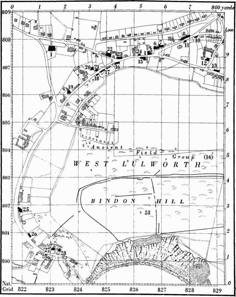
19 LULWORTH, WEST (8280)
(O.S. 6 ins. SY 88 SW, with inset of part of SY 87 NW)
West Lulworth parish, formerly part of Winfrith Newburgh, lies 7 m. S.W. of Wareham. It covers 2,593 acres and lies almost entirely on Chalk. Along the coast there is a strip of Portland limestone, which at one point has been breached by the sea and the narrow outcrop of the soft Wealden Beds eroded to form the well-known Lulworth Cove. Immediately N. of this the land rises steeply to Bindon Hill, a narrow ridge of Chalk rising to over 500 ft. above O.D. Beyond, the land first falls into a narrow valley in which the village lies and then rises to a high chalk area between 400 ft. and 500 ft. above O.D. and extensively cut into by dry valleys sloping N.
The parish now includes two rectangular blocks of land, one to the E. of the village round St. Andrew's Farm, and the other to the N. around Belhuish Farm, which were detached parts of East Stoke parish until quite recently. Both farms are the sites of small mediaeval settlements.
Burngate Farm, near which are the remains of Mount Poynings, the 16th-century seat of Lord Poynings (see Monument 34), was also a mediaeval settlement, first recorded in the mid 13th century (Fägersten, 141). Bindon Abbey was originally founded on the S. side of Bindon Hill, before it was transferred to Wool. Most of the S.E. part of the parish is now an army range area.
The principal monument is the extensive earthwork of Iron Age 'A' date on Bindon Hill.
Ecclesiastical
(1) The Parish Church of the Holy Trinity was built at the W. end of the village in 1869–70 by J. Hicks to the designs of G. R. Crickmay. The old church of the Holy Trinity stood 350 yds. to the E. The only remains of the old structure are in the N. vestry of the new church where the 19th-century E. window has a reused 16th-century rear arch, triangular and moulded, springing from demi-angels bearing shields, one charged with a chalice and wafer, the other paly: on the moulding of the arch is carved a black-letter inscription 'Robeirtus Lulleworthi'. In the chancel is an oak Bench with carved framing and panels of the 17th century extensively restored with new wood. A sketch of the old church is preserved in the vestry.
The Graveyard of the old church remains on the N. side of the village street, and the monuments there include, towards the N.E. corner, a Headstone to William Willis, 1714, Elizabeth his wife, 1761, and John their son, 1802.
(2) Little Bindon (830798) is a single-storey building, in part with semi-attics, of stone rubble and with a tiled roof. The Cistercian abbey of Bindon was founded here in c. 1150 but removed to a different site in 1172 (see Wool, Monument 3). The present building was erected close to the original abbey site in the 13th century. The E. part formed a chapel, re-roofed c. 1500, which has been repaired and altered in more modern times though long disused for ecclesiastical purposes; the W. part has been modernised as a cottage.
The building is a simple rectangle on plan including chapel and cottage separated by a stone cross wall. The S.E. and N.W. corners of the chapel appear to be undisturbed 13th-century work but the rest has been rebuilt with the addition of later buttresses. The E. wall is gabled and has a parapet repaired in modern brickwork rising from reused 12th-century kneelers, one carved with the bearded and crowned face of a man, the other with the face of a monster. Reset in the E. wall is a 13th-century lancet window with chamfered jambs and head; the other windows are of 13th-century lancet shape but all the dressings are in brick, probably of the 18th century. The doorway to the chapel is original with chamfered jambs and continuous two-centred head. The ceiling forms a four-centred plaster barrel vault divided by timber ribs into twelve panels, probably of c. 1500. Six shields-of-arms at intersections of the ribs described in Hutchins (I, 441) have been removed; they had been added by the Welds, who bought the property in 1641, and included their own shield and crest. A piscina S. of the altar is recorded in Hutchins (ibid.). The cottage retains no old features.
Secular
(3) St. Andrew's Farm, house (836811), is of two storeys with stone walls and tiled roof. It was built on a long rectangular plan in the 17th century, the eastern part being perhaps earlier than the western. The central porch is dated 1759 and there are later additions along the back. Most of the windows were refitted with sliding and double-hung sashes in the 18th and 19th centuries, but a few 17th-century stone-mullioned windows remain.
The Outbuildings include: Barn, of nine bays with stone walls and roof carried on jointed-cruck trusses, 17th-century; Barn, probably late 17th-century, of brick and stone with later tiled roof; Cottages, of fairly modern construction but incorporating walling of 17th-century brickwork above a stone base.
(4) Burngate Farm, house (835816), of two storeys with walls of rubble partly rendered with stucco and with tiled roofs, comprises two wings built against two sides of a barn and linked only by a porch. It is of uncertain date and may include material from Mount Poynings (Monument 34). The main S.W. block was completely remodelled in the 19th century, but the wall thicknesses suggest that it is at least in part of earlier construction. The N.E. wing has windows, one of which was formerly a doorway, all framed with reused 16th and 17th-century dressed stonework; inside is a chamfered ceiling beam also probably reused.
Barn, in the re-entrant angle between the two parts of the house, is probably of 16th-century origin; the rubble walls have been largely rebuilt and the roof is entirely modern, but the lower parts of two jointed cracks remain at and near the S. end.
Monuments (5–33) unless otherwise described are cottages of one storey and attics or two storeys and have walls of cob or rubble (the numbers of each are about equal) and thatched roofs; they are of the late 18th or early 19th century and most are built on a two-room plan with a central entrance. Only those buildings differing from this description are mentioned below.
(5) Cottage was built in the 17th century on a small two-room plan and enlarged in the 18th century.
(6) 'Castle' Inn is of the late 18th century with an added wing at the back.
(8) Cottages, three, are in a range previously containing only two. The E. cottage is of the 17th century with rubble walls and central chimney-stack. The W. pair is formed out of one early 18th-century dwelling with rubble walls.
(11) Cottage has one end wall of 17th-century brickwork in which are set two terracotta plaques, one showing the crowned head of Anne Boleyn, the other her badge, a falcon with wings outspread, crowned and holding a sceptre (see also Poxwell (3), Outbuildings).
(12) Lulworth Farm, house, has a tiled roof. A wing projects at the back.
(19) The Old Barn was built in the late 18th century and has been converted into a dwelling.
(25) Bricklesey Cottage has a central chimney-stack.
(26) Cottages, two, one with only one ground-floor room.
(27) Cove Cottage is of the mid 18th century. A third room was added and the walls rendered with stucco in the 19th century.
(28) Spring Cottage is built of brick and has french windows and a verandah; c. 1840.
(29) The Dolls' House has timber-framed walls covered with plaster and a tiled roof. It consists of a front living room with two bedrooms above and a lean-to scullery behind.
(30) Barn, at Newlands Farm (811810), has walls of rubble and flint with brick dressings and the roof covered with tiles. It is of the late 18th century and is said to have been an outlying barn of Hambury House before the present late 19th-century Newlands farmhouse was built.
(31) Barn, at West Down Farm (819815), has a modern tiled roof and has been enlarged.
(32) Belhuish Barn (827827) has walls of stone and brick and the roof covered with tiles. It is probably of the early 18th century.
(33) Belhuish Farm, house (829830), is a T-shaped building. The N. wing was built in the 17th century and has walls of cob above a stone plinth, with a chimney at the N. end and opposed doorways at the S. It was heightened when the main part of the house was built in the late 19th century.
West Lulworth
Earthworks, Etc.
Mediaeval and Later Earthworks
(34) Mount Poynings (83578176), 1 mile N.E. of Holy Trinity Church, is the site of a house of that name built by Thomas, Lord Poynings, probably between 1541–6 (J. Coker (ed.), Survey of Dorsetshire, 44; Hutchins I, 441); the property was joined to that of Lulworth Castle (Lulworth, E., 3) in the early 17th century, but the date of demolition of the house is uncertain. Earthworks, much disturbed, lying N. and E. of Burngate Farm (Monument 4) on ground sloping S. and E. about 400 ft. above O.D., include platforms for structures and, probably, gardens, but the precise position of the house is not known (R.A.F. V.A.P. CPE/UK 1821: 2430–1).
Other Earthworks and Allied Monuments
(35–52) Round Barrows, p. 445.
(53) Iron Age Earthworks on Bindon Hill, p. 489.
Ancient Field Groups (15–16), p. 628.