An Inventory of the Historical Monuments in Dorset, Volume 2, South east. Originally published by Her Majesty's Stationery Office, London, 1970.
This free content was digitised by double rekeying. All rights reserved.
'Studland', in An Inventory of the Historical Monuments in Dorset, Volume 2, South east(London, 1970), British History Online https://www.british-history.ac.uk/rchme/dorset/vol2/pp276-283 [accessed 30 April 2025].
'Studland', in An Inventory of the Historical Monuments in Dorset, Volume 2, South east(London, 1970), British History Online, accessed April 30, 2025, https://www.british-history.ac.uk/rchme/dorset/vol2/pp276-283.
"Studland". An Inventory of the Historical Monuments in Dorset, Volume 2, South east. (London, 1970), British History Online. Web. 30 April 2025. https://www.british-history.ac.uk/rchme/dorset/vol2/pp276-283.
In this section
33 STUDLAND (0382)
(O.S. 6 ins. aSY 98 SE, bSZ 08 SW, cSZ 08 NW)
The parish of Studland, covering some 5,100 acres, lies between Poole Harbour and Studland Bay, 7 miles S.E. of Wareham. Its S. boundary is the hog-back Chalk ridge of the Purbeck Hills, rising to over 500 ft. above O.D. To N. of this the land slopes gently across a narrow outcrop of Reading Beds and London Clay at about 200 ft. above O.D. to heathland, on Bagshot Beds, which reaches to the indented shores of Poole Harbour. The parish also includes Brownsea, an oval island of some 500 acres at the E. end of Poole Harbour, and a number of other small islands, all of Bagshot Sands and Gravels.
The modern parish is the result of late 19th-century boundary revision. Before then a long narrow strip of land running N. from the Purbeck Hills to Poole Harbour, its boundaries still marked by lines of stones, was part of Swanage parish, thus leaving the W. side of the present parish completely detached from the main E. part.
Studland village, the original and still the only major settlement, lies in a sheltered position below the Purbeck Hills and at the S. end of the broad arc of Studland Bay. Claywell in the formerly detached W. part of the parish was in existence by the early 14th century, but retains no old buildings; apart from this the heathland has remained empty of settlement except for a few small farms along the shores of Poole Harbour, the direct descendants of fishermen's cottages known to have existed there at least from the 17th century. Within the parish is the site of the abortive 'new town' of Edward I, probably at the S. end of Newton Bay, but nothing remains to indicate that it ever developed.
The Parish Church and Brownsea Castle are the principal monuments.
Ecclesiastical
The Parish Church of Saint Nicholas, Studland, Dorset
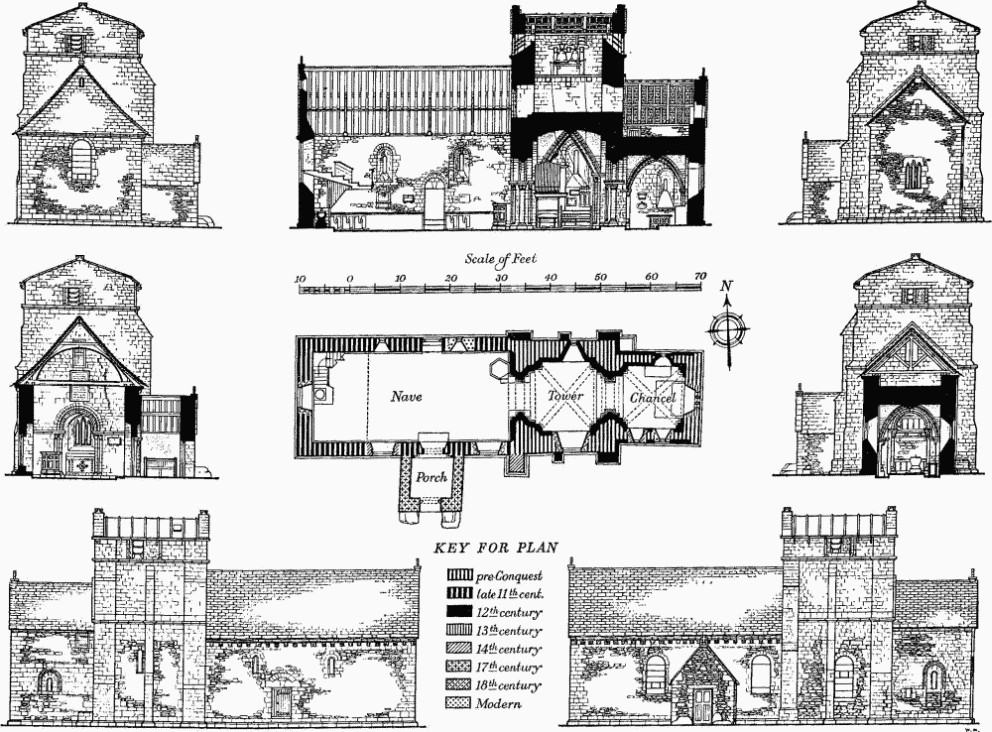
b(1) The Parish Church of St. Nicholas (Plates 161–2) stands in the E. part of the village; the walls are of local rubble partly refaced in ashlar and the roofs are covered with stone slates. The church was built probably shortly before the Conquest, with chancel, central tower and nave. The Nave was rebuilt in the late 11th century, partly on the foundations of the earlier nave; these were uncovered during the restoration of 1880–81 (Dorset Procs. XII (1891), 164). In the mid 12th century the standing Chancel and Tower were partly refaced and remodelled, new arches, windows and vaulting being inserted, and the nave walls were given new chamfered plinths and base courses and corbel-tables. The South Porch was added probably in the 17th century. Some rebuilding took place in the 18th century; a general restoration followed in 1880–81; the nave roof was reconstructed in 1930–31, and the roof of the tower was renewed two years later.
The church is an interesting example of mid 12th-century elaboration of a comparatively small and simple pre-Conquest church. The building has a solid robustness of character which is impressive.
Architectural Description—The Chancel (12¼ ft. square) has pre-Conquest walls of rubble with irregular ashlar quoins and 12th-century insertions in ashlar comprising a plinth and base course above it, upper quoins and, on the N. and S. walls, bands of facing stones. The E. window is of the 13th century and has three graduated lancet lights grouped under one chamfered segmental-pointed rear arch; the centre light has angular cusping. High up in the E. gable is a small round-headed loop light, of the 12th century, reset. The N. wall has a small round-headed window with deep internal splays; outside, the opening is set in a round-headed panel of plain 12th-century ashlar defined by a moulding, the whole occurring in a broad horizontal ashlar band between the rubble walling above and below. During restoration it was revealed that this ashlar was a thin refacing to the pre-Conquest rubble walling. High up towards the W. is a doorway giving access to a room above the chancel vault; it is probably post-mediaeval. The S. wall has more extensive 12th-century ashlar refacing; the S. window is similar to the N. window but restored, having probably been reconverted from a doorway; to the W. and at a lower level is a small late mediaeval rectangular window with dressings chamfered outside and rebated inside. Internally both N. and S. walls are faced with 12th-century ashlar. In the W. wall is a round-headed archway of two orders; the inner order and the outer order on the W. are moulded and spring from attached shafts with scalloped capitals and abaci enriched with chevron ornament. The abacus is continued on each side to form the springing for the plain E. outer order, with plain responds below. Over the chancel is a ribbed quadripartite vault of stone, with some modern repairs in cement. The diagonal ribs are moulded and spring from angle shafts with carved capitals and moulded bases; those in the W. corners have been partly cut away. To E. and W. are stilted wall-arches springing from plain responds with abaci continuous with those of the vaulting shafts. The above are all part of the mid 12th-century remodelling of the earlier structure. Over the chancel is a room with a plain square-headed doorway to the tower; the doorway has been partly blocked with modern brickwork.
The Central Tower (13 ft. by 14 ft.) is of two main stages and the lower part of an incomplete third stage; the stages are divided by chamfered strings. It is initially a pre-Conquest structure, but the plinths, the buttresses, with one exception, and the ashlar work are all of the mid 12th century; the third stage may well have been an innovation at this later date. The E. and W. walls, which are ashlar-faced, finish in low-pitched gables with plain parapets; the E. parapet rises from kneelers cut to fit the existing roof slope but the kneelers to the W. parapet are shaped for a much steeper roof. The lower half of the N. wall is of rubble with an inserted chamfered plinth and the upper half is faced with ashlar; at the ends are broad pilaster buttresses of ashlar, rising to the eaves, and between them is a narrower central buttress stopping below the upper string-course. The S. wall contains some rubble facing on the outside of the lower part but is mostly refaced with ashlar and with an inserted chamfered plinth; the three buttresses are similar to those to the N. wall, but here the E. buttress only is carried up to the eaves and the W. buttress has been rebuilt, probably in the 14th century. The N. wall has on the ground stage a small 12th-century single-light window; in the S. wall the corresponding window was enlarged and lowered in the 18th century but the 12th-century rear arch remains above. The incomplete third stage has in each wall the truncated lower part of a 12th-century window with shafted jambs, that to the E. being divided into two lights by a central shaft; these openings are partly blocked and have small rectangular openings in the blockings. The lower stage of the tower has a mid 12th-century quadripartite vault with moulded ribs springing from angle shafts with cushion capitals with moulded abaci and moulded bases with corner spurs on square plinths; the E. capitals are carved with formal decoration. The E. and W. walls only have plain rounded wall-arches, boldly stilted, springing from abaci continuous with those just described.
The round-headed archway to the nave (Plate 161) is of two orders, the inner moulded, the outer moulded on the W. side only. The moulded orders spring from engaged shafts with scalloped capitals and abaci enriched with chevron ornament and with moulded bases with plain spurs above square plinths. The outer order to the E. is plain and springs from responds which have been cut away below the abaci for a former screen. On the W. side the abaci are continued to the N. and S. walls and over the arch is a label also with chevron ornament.
The Nave (39 ft. by 18 ft.) is of the late 11th century. The N. wall has an added mid 12th-century corbel-table of twenty-three corbels (Plate 7) carved with beasts' heads, human heads, grotesques and a saltire. Towards the E. end is a small modern window set partly in the blocking of a doorway which was some 7 ft. above ground and may have given access to a gallery from an external stairway; this modern window probably reproduces an original feature. The N. doorway is of the 11th century and has a keyed lintel with a semicircular relieving arch of which the springers are cut into the top of the lintel; the jambs are much restored. To the W. is an 11th-century window of one small round-headed light. The S. wall is extensively patched and refaced; it has a corbel-table at the wall-head similar to that on the N. but some corbels are defaced, some carved with formal decoration and some only shaped. The eastern window of one large round-headed light, with brick rear arch, is of the 18th century. The doorway has a keyed lintel within an outer order of a plain round arch springing from attached shafts with moulded bases with spurs, scalloped capitals and abaci; the last are continued round the plain door jambs. To the W. is a window with late mediaeval jambs and an 18th-century round-arched head; above is the head of an original 11th-century window similar to that opposite. The W. wall has a 12th-century string-course at eaves level above which the gable is an 18th-century rebuilding in ashlar. There is a single round-headed W. window of the 18th century. The South Porch (8½ ft. by 7½ ft.) has an entrance with a modern flat head.
Fittings—Bells: four; all recast in 1898, 1st perhaps 17th-century; 2nd and 3rd by William Knight, 1736; 4th by C P, 1065 (sic). Brackets: In tower, (1) pair of shaped stone corbels to carry a rood beam. In nave, on S. wall, (2) long chamfered corbel, mediaeval. Chairs: pair, modern but made up with arcaded back panels of the mid 17th century. Coffin-lid: in nave, at E. end, set in floor, plain, mediaeval. Doors: in N. and S. doorways, of two leaves and of fielded panels, early 18th-century. Font: plain stone tub with circular base set on modern plinth, 12th-century. Hatchments: in nave, (1) with shield-of-arms of Bankes impaling Bastard, for Edmund George Bankes, died 1860; (2) with shield-of-arms of Bankes impaling Nugent, for George Bankes, died 1856. Inscriptions and Scratchings: on E. jamb of S. door, a cross.
Monuments and Floor-slabs. Monuments: in chancel—against N. wall, (1) table-tomb with moulded Purbeck marble top, front and W. end carved with cusped panels, main panels being sub-cusped quatrefoils enclosing shields on which were originally brasses, early 16th-century, with modern E. end; (2) to the Rev. John Morton Colson, LL.B., Rector, 1837, white marble tablet; in tower—on S. wall, (3) to Francis Fane, 1813, white marble tablet with shield-of-arms above, signed Henry Westmacott, London; (4) to Ann, widow of Francis Fane, 1832, white marble tablet; in nave—on S. wall, (5) to the Rev. Benjamin Culme, Judith (Layphield) his wife and their ten children, also John Layphield brother of Judith and his three sisters, also James White who married Ann the granddaughter of Benjamin and Judith and who erected the monument in 1772, marble tablet with enriched apron and entablature, with later inscription to Ann White, 1807. Floor-slabs: in chancel, (1) to Ann (Beaumont), widow of George Brown, 1713; (2) to Frances, daughter of Sir William Meaux, 1662, with shield-of-arms; inscription not now legible, see Hutchins I, 654.
Painting: in nave—on E. wall over arch to tower, (1) within a border, Psalm lxxxiv, 1 and 2, 17th-century; on N. wall, (2) fragments of formal decorative border in red and black, perhaps 12th-century. Plate: includes cup of 1630 (Plate 23) and cover-paten by Lawrence Stratford of Dorchester, 1575, and two stand patens of 1718 given by Edmd. Pleydell.
Miscellanea: (1) processional cross, head, on modern staff, consisting of lozenge-shaped brass plate pierced and bordered with crosses, decorated with small incised circles and with inscription, beginning in Geez and ending in Amharic, saying 'This is the cross of the chief merchant Baroch Zaro', 19th-century, said to have been brought from the chapel of King Theodore of Abyssinia at Magdala in 1868; (2) outside, on N.E. corner of chancel, eight-petalled flower carved in stone, mediaeval; (3) in S. porch, built into E. wall, moulded stone, 12th-century.
c(2) The Church of St. Mary, Brownsea Island (028877), was built in 1853–4 at the charge of Col. William Petrie Waugh. The lower storey of the tower, forming a private pew (Plate 29), has a Ceiling of timber, probably made up from parts of the ceilings of the Parlour and Great Chamber removed in the early 19th century from the house built by Sir John Crosby in the City of London in 1466 and demolished in c. 1906 (Survey of Greater London: Philip Norman, Crosby Place (1908), 52).
The flat ceiling is divided into two bays by a moulded cross beam supported on cusped arched braces springing from short wall-posts; wall-beams enclosing the ceiling are similarly moulded and braced. Each bay is divided into six panels by moulded ribs, each panel being enriched with cusping and subcusping round a foliated patera in the middle. (See also Panelling below.)
Fittings—of Italian or S. German origin unless otherwise described, mostly collected by the Hon. G. Augustus Cavendish Bentinck, owner of the island from 1870 to 1890. Bracket: S. of chancel arch, with cartouche containing shield-of-arms and with panelled sides, 17th-century. Candelabrum: in tower, with two tiers each of eight branches, English, 18th-century. Candlesticks: on screens, four, of painted and gilded wood carved with cartouches, cherubs' heads and acanthus foliage, a fifth carved as an angel on a scrolled pedestal, 17th-century. Painting: in tower, of the Crucifixion, Italian, 17th-century. Panelling: in chancel, in screen to N. vestry, in S.W. chapel and in tower, panels carved with formal patterns enriched with foliage and vine-trails, English, 16th-century (some reported to be from Crosby Place), made up with modern framing. Plate: includes two brass candlesticks dated 1716, altar cross, two smaller brass candlesticks and two small jars all of the same date; two candlesticks of silver-gilt with elaborate foliage ornament, 17th-century; alms-dish of brass, with the Annunciation within bands of lettering, German, 16th-century; one lamp, of silver-gilt (?), enriched with foliage, flowers and cartouches and suspended by chains attached to projecting human heads, 17th-century (?). Miscellanea: In vestry, tapestry with landscape with birds, perhaps French, 18th-century. In nave, carved panels of the Annunciation and the Adoration of the Shepherds, probably Flemish, 17th-century; carved roundel with kneeling figure of angel, 16th-century; on tower screen, panel of painted wood and plaster portraying the Annunciation. In tower, figure of Faith (Plate 30) and companion figure of man holding a shoe and a knife (February?), Flemish, c. 1500; two carved wood figure groups, from an Entombment and the Presentation in the Temple, Flemish, early 16th-century (Plate 30), perhaps from an altarpiece.
Secular
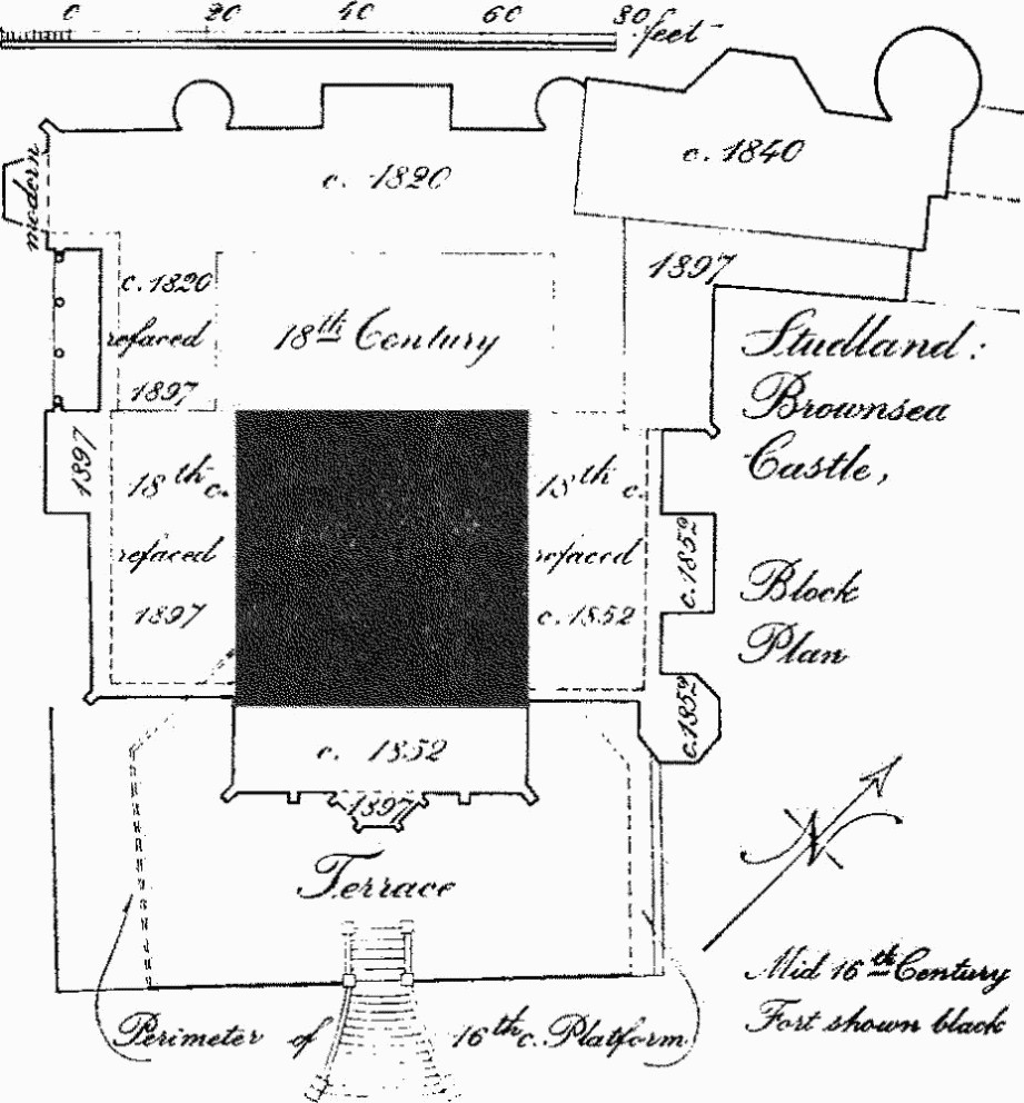
c(3) Brownsea Castle (Plates 158–60), also known by the old name of Branksea Castle, stands at the E. end of Brownsea Island (030876). The original castle formed part of Henry VIII's system of coastal defences, its role being to cover the entrance to Poole Harbour. It was built and maintained by the town of Poole and the payment in April 1547 of 33s. 4d. for lead for the castle (Poole Town Accounts 1546/7, 49 (4)) supports the statement in a document of 1573 (Great Book of Poole, f. 54) that the castle was finished in 1547; but work evidently continued into 1548 when £56 7s. was paid for finishing the platform etc. (ibid., f. 54). In 1551 a hundred and one piles were set (Town Accounts 1551, 51 (6)) which suggests some sea encroachment. Following a complaint in 1571 (Old Record Book (E) 1564–72, f. 10) that the castle was ruinous, further works were put in hand, £520 being paid out in 1573 in addition to the provision of 4,000 tons of rough stone and chalk (Town Accounts, 1573). In 1585 repairs included work on the stone fabric, loop-holes and windows and leadwork, strengthening the gun platforms and the completion of a four-foot wall round the castle (P.R.O. Exchequer Q.R. Accounts, E101/462/7). From this account and from the detailed view and plan (Plate 158) inset on a map of Poole Harbour of 1597 in the Hatfield Collection (also B.M. maps 186 h 2(32)) it is evident that the castle originally consisted of a square single-storey stone building surrounded on three sides by a moat and with a hexagonal gun platform on the fourth, seaward, side enclosed by a low wall. The entrance was in the S.W. side approached across the moat over a drawbridge 24 ft. long. In the view three guns are shown on the roof of the main structure, but the stone-paved platform is empty of guns and the wall to it partly broken down. On plan the main structure is shown divided into three rooms.
In 1576 the castle was granted to Sir Christopher Hatton (Great Book of Poole, f. 128). It was garrisoned during the 17th century and additional guns were ordered by the House of Commons in 1645/6. In the early 18th century the island was bought by William Benson, who was M.P. for Shaftesbury and in 1718 succeeded Sir Christopher Wren as Surveyor of Works, subsequently becoming Auditor of the Imprests. He began the conversion of the castle into a residence, adding a Great Hall.
In 1765 Humphrey Sturt acquired Brownsea from his cousin, Sir Gerard Napier of More Crichel, and built up the castle to a four-storey tower with lower wings on three sides; thus it is shown in engravings in Hutchins (I, 646–7) as a simple building with embattled parapets and windows mostly of either Palladian or arched form (Plate 160). The engravings also show a courtyard enclosed by a wall with corner pavilions on the site of the present walled garden N.E. of the castle.
Studland: Brownsea Castle
In the first quarter of the 19th century the building was enlarged to the N.W.; it was further extended to the N.E. in the second quarter of the century. Colonel William Waugh, who bought the island in 1852, added a new S.E. front range in the Tudor style and refitted the interior. He also built the Family Pier and Watch Towers, the Gatehouse, Stables and other buildings on the island. His hope of finding china-clay and working it came to nothing and Brownsea was offered for sale by auction in 1857; copies of a map and inventories of the buildings prepared for the sale are preserved in Poole Public Library. After some delay it was sold in 1870 to the Hon. Augustus Cavendish Bentinck who brought to the castle a collection of Italian stone carvings. It changed hands again in 1892 and shortly after was severely damaged by fire. Rebuilding in 1897 included most of the S.W. and N.E. side elevations and much of the interior. The castle now belongs to the National Trust.
Brownsea Castle is now in general aspect a building of the later 19th century, but it contains more or less concealed the greater part of the Henry VIII coastal fort of 1547–8.
In the basement of the castle, rising the full height of the storey and forming the base of the lofty central block, the walls of the original mid 16th-century Fort remain. They are stone-built and though now mostly faced with modern plaster are identifiable by a pronounced batter. Measured at the highest level possible they form a rectangle 43 ft. by 44 ft. externally; the interior is not fully accessible. In the S.W. wall are clear indications of the original entrance, though now completely blocked. The S.E. retaining wall of the terrace consists largely of the original wall which enclosed the projecting gun platform.
The N.W. front shows a symmetrical composition in three storeys with windows of Palladian type but with pointed arches and with plain stone architraves, arranged between round turrets pierced by windows of single pointed lights. The composition is cut short at the N.E. end by the slightly later addition which has itself been drastically altered but finishes with a larger round turret at the N. corner.
The brick Gatehouse, 30 yds. N.E. of the castle, built c. 1852, has rusticated quoins and an embattled parapet and is surmounted by a clock turret; it is joined to the N. turret of the castle by a range of low buildings also of c. 1852 but incorporating some earlier walling. The Family Pier (Plate 160), E. of the castle, is a picturesque brick construction of c. 1852 consisting of a covered gallery and an open terrace carried on brick arches leading to a landing stage flanked by two octagonal stucco-faced watch towers in the Tudor style. In the gallery are numerous stone carvings, probably all Venetian, including fifteen with shields-of-arms, two dated 1601 and 1619 respectively, three with the Lion of St. Mark, three basins and a door-head, 16th and 17th-century.
The Houses, Shop and Workshop, N.E. of the castle, are of the 18th and mid 19th centuries. All are of brick with the principal elevations stuccoed; the largest house has embattled corner turrets. Reset in the walls are Italian stone carvings of shields-of-arms, and in a boundary wall by the quay is a carving of St. Christopher in high relief.
The Enclosure, 165 yds. W. of the castle, is of the 18th century. Two brick walls remain, one now forming the W. side of the dairy yard and the other incorporated into a later building. They have a moulded brick plinth and serrated cornice and heavy rustication of the quoins and the piers flanking a gateway. South Shore Lodge (019875) is a small L-shaped house of late 18th-century origin, much altered. Maryland (011882) comprises four blocks, each of four dwellings, erected for clay-workers by Col. Waugh in c. 1852. The Villa (025881) was incomplete in 1857.
In castle grounds, Miscellanea—Cannon: on terrace, 2 ft. 10 ins. long and 2¼ ins. bore; in garden, three, 5 ft. long and 3¼ ins. bore; the latter with foundry mark of a rose and crown and, on the trunnions, the founder's initials RF; 17th or early 18th-century. Statue (Plate 62), in grounds, of stone, of man in cuirassier armour and cloak, with laurel wreath on head, baton (broken) in left hand, helmet at feet, late 17th or early 18th-century (removed since Commission survey).
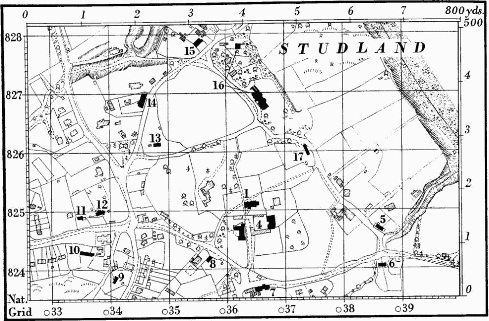
Monuments (4–25) unless otherwise described are small houses and cottages of the 18th century, of one storey and attics or two storeys, and with rubble walls and thatched roofs. The single cottages (8, 11, 12, 19, 23) each comprise, on plan, one main room with a fireplace against the gable end wall and one or two small unheated rooms at the opposite end. The cottages built in ranges of two or three together (6, 9, 10, 14) are similar to the foregoing on plan.
b(4) Studland Manor Farm, house, of two storeys and attics, and with roofs covered with stone slates, comprises a N.-S. range with a low W. wing and a cross wing at the S. end. The main range has an upper storey of brick of the first half of the 18th century; the lower storey with rubble walls may be earlier. The range was at one time two dwellings and the brickwork of the N. part is slightly earlier than that of the S., but the whole has been much altered. The S. wing is of the late 19th century. Barn, on E. side of farmyard, with walls of rubble and brick and roof covered with stone slates, is of the 18th century.
b(5) Cottages, two, were built probably as one house which was divided when a third cottage was added.
b(6) Cottages, two.
b(7) Cottages, two, were built in the 17th century when they probably comprised two rooms to the E. of the chimney-stack and an entrance passage and third room to the W. The W. part was later heightened and enlarged to form a separate cottage, with a new chimney and stone-slated roof. The E. part was rearranged to form a cottage with one heated room separated by a through passage from two small unheated rooms. Original stop-chamfered ceiling beams remain. Barn, to E., is continuous with the E. cottage and has a porch projecting N. under a hipped roof.
b(8–12) Cottages, see introductory note.
b(13) Cottage, roofed with stone slates, is of the early 19th century and has a chimney at each end.
b(14) Cottages, three.
b(15) Beech Cottage, now a single dwelling, was built as two cottages.
b(16) Studland Manor, hotel (160 yds. N.), of two storeys with attics, has walls largely of brick in the upper parts and all rendered in stucco; roofs are covered with stone slates. It is probably the 'marine villa' described by Hutchins (I, 644) as built by the Rt. Hon. George Bankes, who died 1856, but it may incorporate some earlier walling; it has been enlarged and modernised.
The elevations exhibit a contrived romantic irregularity, having gabled dormers, a glazed turret above the entrance and, joined to the N.W. part of the house, two small round towers, their inspiration perhaps being the notion that this is the site of the mediaeval Studland Castle.
Inside, the main staircase is a reconstruction in 18th-century material. The first-floor landing has Gothic shafts with moulded caps and bases flanking the doorways and similar shafts supporting segmental and trefoiled plaster ceiling vaults. One of the first-floor rooms has a mid 18th-century fireplace surround with carved frieze and a door-case with a carved panel of Orpheus with beasts and trees. Barn, to N., of the 18th century, is now converted to a garage.
b(17) Church Cottage consists of two cottages converted to one.
b(18) Wadmore Farm, house (029829), is roofed with stone slates and has been extended.
Studland
b(19) Cottage (030826), built partly of brick, is of the late 18th century.
b(20) Harmony Lodge (02928231) is of the late 18th century.
b(21) Cottages, Nos. 42, 43 Woodhouse (029820), were built probably in the late 17th century as a single dwelling with central entrance and one end chimney, with an outhouse beyond; it was divided into three tenements and subsequently remodelled as two. Variations in the masonry suggest that it has been partly rebuilt.
b(22) House, Nos. 44, 45 Woodhouse (028820), is of the late 17th or early 18th century; originally comprising on plan three rooms and a through passage, it was later extended by the addition of an outbuilding to the N. and divided into two tenements. The interior retains an original plank partition.
b(23) Cottage, Searley's Knap (021818).
b(24) Kingswood Farm, house (001819), roofed with stone slates, is L-shaped on plan. It was built in the early 18th century with a main range containing a living room with a chimney at one end and a small room partitioned off at the other end; the kitchen with a gable-end fireplace is set at right angles to the main range. Extensions were made in the late 18th century.
c(25) Newton Cottage (004851) takes its name from the borough of Newton proposed by Edward I for this area; it has walls of carstone rubble rendered with modern stucco and a slate-covered roof. It is of the late 17th or early 18th century, but extensively modernised, and has on plan a straight range of three rooms, all with fireplaces.
b(26) Boundary Stones, on Ballard Down, mark the boundary between Studland and Swanage parishes. One (Plate 64), at 03758132, is 1¼ ft. by 6½ ins. and 2½ ft. high with a rounded top; coarse diagonal tooling covers top and sides. The N. face is inscribed 'Studland Manor 1776'.
Earthworks, etc.
Mediaeval and Later Earthworks
b(27) Strip Lynchets (044815), two, contour type, 200 yds. long, lie at the foot of Ballard Down, adjacent to 'Long Lands' (Tithe Map 1840). (R.A.F. V.A.P. CPE/UK 1893: 4300–2.)
c(28) Settlement Remains, house footings and other structures, lie at the base of the Goathorn peninsula on Studland Heath near the S. shore of Poole Harbour and were formerly in Swanage parish. The remains are in a broad shallow valley with many oaks. The house (01138521), probably 17th-century, had two rooms: that to the W. was 10 ft. by 14 ft.; that to the E. was 29 ft. by 12 ft. narrowing to 10 ft. at the E. end and had a doorway at the W. end of the S. wall with a window just to the E. A rubble pile suggests a chimney breast against the partition wall. Two structures near by are marked by clayey banks only. The first, 30 yds. S. of the house, is 22 ft. by 10 ft.; a bank running W. from its S.W. angle supports an oak tree probably 350 years old. The second, about 40 yds. W. of the house, is 15 ft. by 9 ft. These remains are close to, but cannot be identified with, the site of Edward I's proposed new town, Newton. (Med. Arch, VII (1964), 223–6.)
Other Earthworks and Allied Monuments
(29–42) Round Barrows, p. 452.
(43) Studland Circles, p. 504.
(44–47) Roman Buildings and other Remains, p. 609.
Ancient Field Group (29), p. 632.