An Inventory of the Historical Monuments in Dorset, Volume 2, South east. Originally published by Her Majesty's Stationery Office, London, 1970.
This free content was digitised by double rekeying. All rights reserved.
'Wareham Lady St. Mary', in An Inventory of the Historical Monuments in Dorset, Volume 2, South east(London, 1970), British History Online https://www.british-history.ac.uk/rchme/dorset/vol2/pp303-326 [accessed 30 April 2025].
'Wareham Lady St. Mary', in An Inventory of the Historical Monuments in Dorset, Volume 2, South east(London, 1970), British History Online, accessed April 30, 2025, https://www.british-history.ac.uk/rchme/dorset/vol2/pp303-326.
"Wareham Lady St. Mary". An Inventory of the Historical Monuments in Dorset, Volume 2, South east. (London, 1970), British History Online. Web. 30 April 2025. https://www.british-history.ac.uk/rchme/dorset/vol2/pp303-326.
In this section
38 WAREHAM LADY ST. MARY (9287)
(O.S. 6 ins. SY 98 NW)
The parish, now also the modern borough of Wareham, covers some 700 acres of land almost all on alluvium and river terraces of the rivers Piddle and Frome, nowhere much above 50 ft. above O.D. The main part of the parish occupies a long narrow peninsula lying roughly E.–W. bounded on the N. by the R. Piddle and on the S. by the R. Frome, here under a mile apart, flowing E. to Poole Harbour. In the central and narrowest part of this peninsula is the town of Wareham in a position of great tactical and strategic strength bounded by its Alfredian ramparts.
The parish has been subject to much modern boundary revision with the result that it has lost land to the W. to Arne and gained land N. of the R. Piddle from the parishes of Morden and Wareham St. Martin.
Wareham itself and Northport, a small suburb on the N. side of the R. Piddle on the main road N. out of the town, are the only major settlements. Northport was formerly a detached part of Wareham St. Martin.
Numerous Roman finds within the town indicate a substantial occupation and the existence of at least one building of distinction in this period, but the main development came later. Christian British inscriptions of the 7th–9th centuries and the burial of Brihtric, King of Wessex, in Wareham in 802 (fn. 1) imply the existence of a church held in some esteem. It was probably the monastery mentioned by Asser in connection with the events of 876 (fn. 2). The church, as rebuilt in the early 8th century, may be identified with the building which existed on the site of Lady St. Mary until 1840. Moreover Wareham was already a recognised crossChannel port in the early 8th century, (fn. 3) and in the early 10th century it was one of the West Saxon fortified boroughs. The massive ramparts which still enclose the town on three sides are the remains of the defences of this period, and the gridiron street plan probably reflects a contemporary lay-out.
As a site of strategic importance Wareham was superseded by the development of Corfe castle from the late 11th century. But the continued commercial importance of the town is seen in the establishment of Wareham castle within the S.W. corner of the defences in the early 12th century; this led to involvement in the wars of Stephen and Matilda (see Wareham Castle (80)). Thereafter the town seems to have declined in importance, partly owing to the proximity of Corfe castle and partly as a result of the silting up of the higher W. reaches of Poole Harbour. The latter led to the growth of Poole, in a better position, as the main commercial centre of the area. In the 17th century Wareham was besieged twice by each of the parties in the Civil War (C. J. Bennet in Dorset Procs. XIII (1891), 108–9).
The ancient borough status of Wareham was confirmed by a charter of Queen Anne in 1703. In 1762 a fire destroyed more than half the houses in the town and in the following year Commissioners were appointed by Act of Parliament to regulate rebuilding, (fn. 4) which was generally carried out in brick. Thus the devastated middle of the town re-arose as a pleasing assemblage of more or less contemporary buildings. A large number of attractive shop windows of this period survived into the middle of the present century. Hutchins (1st ed., 1774) includes a map of the town showing the N.E. sector without any buildings behind those fronting the main streets; development in the N.W. sector was slight. In the S.E. sector are the two most important houses surviving from before the fire, the Priory and the Manor House. The Quay, in the same sector, is an ancient structure, repaired in 1745 and reconstructed in the middle of the 19th century. The railway to Wareham was opened in 1847.
The remains, both surviving and documentary, of the post-Roman and pre-Conquest development of Wareham are of considerable importance. They comprise the 8th-century predecessor of the present church of St. Mary, no less than five stone-cut inscriptions dating from the 7th to the late 8th or early 9th centuries preserved in the latter, the Alfredian town defences and the early 11th-century church of St. Martin. Since the 8th-century church and the inscriptions demand more discursive treatment than is suited to the Inventory form of entry, they are considered in two Appendices at the end of the account of Lady St. Mary's church (pp. 309, 310).
Ecclesiastical
(1) The Parish Church of Lady St. Mary (Plates 163, 164) stands in the S.E. angle of the town. The walls are of Purbeck stone: in the chancel mostly of rubble, in the S. chapel of rubble mixed with carstone, in the N. and S. aisles and porch of coursed and squared stone, and in the W. tower of ashlar. The roofs are covered with tiles, slate and stone slates. The early 8th-century church, much the size of the present building, in large part survived here until the mid 19th century. This pre-Conquest minster church with its possessions had been given to the Norman Abbey of St. Wandrille before 1086. (fn. 5) It was given by Robert, Earl of Leicester, to the Abbey of Lire (fn. 6) in c. 1150, which established a Benedictine Priory, replacing the canons. (fn. 7)
In the 14th century Wareham suffered the usual disadvantages under which alien priories laboured (fn. 8) and in 1414 the church and its possessions were granted to Henry V's newly founded Carthusian Priory of Sheen. (fn. 9)
The Church of Saint Mary, Wareham Lady St. Mary, Dorset
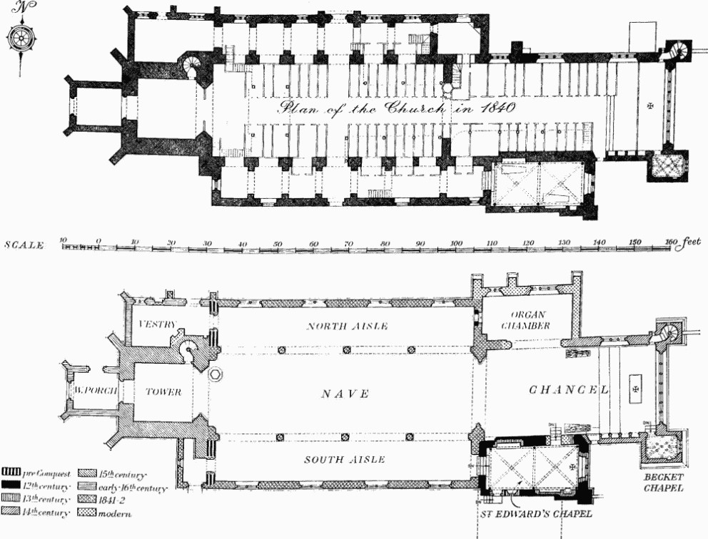
The date and the form of the early church (Plate 163, Fig. p. 305) are discussed in the Sectional Preface, p. xliii, and Appendix A, p. 309. Nothing of the pre-Conquest building is visible above ground in the present church, but the walls at the W. end of the aisles are so placed that they may be assumed to be substantially of this date beneath the modern plaster. The early chancel was probably rebuilt when the present St. Edward's Chapel was added c. 1100. The western part of the S. side of this chapel is thin, suggesting the party wall of a building about 23 ft. wide running S. and forming the E. range of a normal claustral lay-out. In c. 1100 the chapel consisted of a single storey with a floor sunk some 3 ft. below the level of the nave and entered through a W. arch. The lowering of the floor was presumably to allow the upper floor of the range containing the dormitory to extend across the W. part of the chapel up to the S. wall of the church. An upper storey extending over the whole of the chapel was added when the vault was inserted in the latter in the early 13th century; this probably formed a Treasury entered directly from the choir as at present. The Chancel of the church was enlarged in c. 1325, and the vice at the N.E. corner and the Becket Chapel are also of this period. The West Tower was built in c. 1500 and soon afterwards the Vestry was added to it on the N. The West Porch is also of the early 16th century. The present Nave and North and South Aisles succeeded the pre-Conquest aisled nave taken down in 1841–2 together with the W. end of the chancel; the new chancel arch was built 11 ft. E. of the earlier one (measured centre to centre). The new building had galleries at the W. end of the nave and in the aisles; these have since been removed. The work of rebuilding was carried out by Jesse Cornick and Sons of Bridport, apparently to the designs of T. L. Donaldson, who signed the 1840 plan (see p. 309), for £2,122. The Organ Chamber was added in 1882 and restoration work was also carried out then and, to the chancel, in the two following years.
By chance it is possible to reconstruct with accuracy the form of the pre-Conquest minster church and to indicate the importance of it in the history of ecclesiastical building in England. Though most of the ancient structure was demolished immediately prior to the rebuilding in 1841–2, the church of Lady St. Mary is still of much interest for its impressive 14th-century chancel and the remarkable contents, including five pre-Conquest inscriptions, a 12th-century lead font and two 13th-century military effigies. Here too is the grave and memorial tablet of the Rev. John Hutchins, whose History and Antiquities of the County of Dorset (1774) has put all students in this field in his debt.
Architectural Description—The Chancel (47½ ft. by 24 ft.) is a building of c. 1325; unless otherwise described, the features are of this period. It has in the E. wall a very large window (Plate 164) of seven trefoiled and transomed lights with net tracery in a four-centred head and cusping below the transom. At the N.E. corner is an enlarged buttress of ashlar, with a high battered plinth, containing a vice entered from the chancel by a doorway with chamfered jambs and lintel; the vice is lit by small loops and has a doorway at the top opening to the chancel roof. The upper part of the main N. wall and its parapet have been rebuilt. The three-light N. window, with a cinque-foiled light between two trefoiled ogee lights, has geometric tracery in a two-centred head with a label. The opening to the organ chamber is of 1882; it displaced a window, which is now reset in the N. wall of the organ chamber (q.v.). The S. wall has at the E. end a doorway to the Becket Chapel, with chamfered jambs and lintel, the chamfers finishing on shaped stops. The S. window is of the early 15th century and has three cinque-foiled lights and vertical tracery in a two-centred head with a label. The S. doorway has a chamfered two-centred head, continuous jambs with shaped stops, a moulded label and moulded segmental-pointed rear arch. Further W. is a modern doorway with a reused four-centred head; it opens to St. Edward's Chapel and is in part in the blocking of an earlier opening. High above it is a small lancet window and, at the W. extremity of the wall, at halfheight in a recess under a half arch, is a doorway; both open to the room over St. Edward's Chapel. The doorway has a moulded two-centred head with shallow chevron and nail-head ornament springing from moulded imposts below which the moulding is continued down the jambs; the dressings are of the 12th century, reset when the doorway was made, probably c. 1600. The chancel arch, of 1841–2, is of three orders, two-centred and moulded, the centre order continuous and the inner and outer orders springing from attached shafts with moulded caps and chamfered bases.
The Becket Chapel (8½ ft. by 6 ft.), on the S.E. corner of the chancel and of the same build, is of ashlar and has high battered plinths to the E. and S. walls. The E. end of the N. wall is carried up to form a buttress to the chancel and the lower weathered offset of this buttress is continued across the E. wall of the chapel and returned as part of the water-tabling on the S. The E. window has three lights with modern mullions and 15th-century vertical tracery in a segmental-pointed head reused and replacing a window presumably of the 14th century. The stone vaulted roof (Plate 164) has moulded ribs and bosses.
St. Edward's Chapel (26 ft. by 12¼ ft.) is at a lower level than the chancel; it has an upper room, now disused. The thinner part of the S. wall may have been the party wall with a contemporary range extending S., now gone. The vaulting and vaulting shafts and the upper storey are 13th-century additions to the original building of c. 1100. Subsequently the whole wall-head on the S. was lowered. On the S.E. angle is a clasping buttress; under the E. window is a rounded string-course. The 13th-century E. window has two plain two-centred lights and a quatrefoil above; the rear arch is segmental-pointed. The N. wall retains, towards the E., part of the chamfered E. jamb of a former doorway, probably of the 13th century. The S. window has one square-headed light and the S. doorway is of the 19th century. In the W. wall is an early 12th-century archway with plain round head springing from moulded imposts and stop-chamfered responds. The upper floor has the remains of a 13th-century two-light E. window, blocked and with a small rectangular window, perhaps 16th-century, in the blocking and, in the S. wall, a small rectangular loop-light of the 16th century. The chapel is covered by two bays of quadripartite vaulting with chamfered ribs springing from detached circular shafts of Purbeck marble with attached moulded caps and bases; the transverse and wall ribs form two-centred arches and the diagonal ribs elliptical arches; the intersections are recessed and carved with conventional flowers.
The Organ Chamber (25 ft. by 12½ ft.) of 1882 has in the N. wall a reset 14th-century window removed from the N. wall of the chancel; it has a septfoiled centre light between cinque-foiled side lights and curvilinear wheel tracery in a two-centred head with a label.
The Nave (74¼ ft. by 22 ft.) has high over the chancel arch a small two-light window of 1894. The N. and S. arcades are of four two-centred arches of two chamfered orders springing from lofty octagonal piers and attached half piers at the responds, all with moulded capitals and chamfered bases. Each of the clearstorey windows is of two plain lights with tracery in a two-centred head with a label. The walls are carried up to embattled parapets. The North Aisle (11¼ ft. wide) has in the E. wall a reset round window of the 12th century with moulded reveal and, above, a reset 15th-century window with three plain lights and vertical tracery in a two-centred head; both now open to the organ chamber. The N. windows are each of two transomed lights with plain tracery in a two-centred head with a label. In the W. wall, above the N.W. vestry, is a reused 14th-century window of three plain lights with curvilinear tracery in a two-centred head. The South Aisle (11¼ ft. wide) has an E. wall built against the W. wall of St. Edward's Chapel and with an opening for the archway to the chapel; the head of the opening is made up from the cusping of the recess over a 14th-century wall-monument formerly in the chapel on the E. extremity of the old N. aisle (Hutchins I, 111, 112). The S. windows are uniform with those in the N. aisle. In the W. wall is a mid 19th-century doorway with continuous chamfered two-centred head and, higher up, a reset mediaeval window from the N.W. vestry (Hutchins I, 111) with three cinque-foiled lights and curvilinear tracery in a square head with a modern rear arch.
The West Tower (16¼ ft. square) of c. 1500 is of four stages divided by moulded string-courses, with moulded plinth and embattled parapet above a parapet string with grotesque gargoyles; there are angle buttresses to the E. and diagonal buttresses to the W. A polygonal vice projects at the N.E. corner. The tower arch is two-centred and of three moulded orders, the inner order being carried on three-quarter shafts with moulded capitals and chamfered bases; the other orders are carried down the responds, the outer one being interrupted by capitals. The N. wall has a doorway with four-centred head to the vice. The W. doorway has a moulded two-centred head and continuous jambs; above it is a window of four transomed lights with intersecting tracery of 1869 in an opening of c. 1500 with a four-centred head under a label with one shield stop and with the original rear arch. The string at the head of the ground stage is returned below the window. The third stage has a doorway from the vice to the nave roof and, in the W. wall, a window of one cinque-foiled light in a square head with a label. The top stage had in each wall a window of two transomed lights, but mullions and tracery have been removed except in the E. window where the lower half is complete. The North-west Vestry (21½ ft. by 12 ft.), of the earliest years of the 16th century, has a moulded plinth and two-stage buttresses. To E. and N.E. are 19th-century doorways with two-centred heads. The original N. doorway is blocked; it has a moulded two-centred arch within a square head with continuous jambs; in the spandrels are quatrefoils enclosing a Tudor rose and a patera and over all is a label with defaced head-stops. To the W. is an original window of two cinque-foiled ogee lights in a square head; the mullion is a renewal. The W. wall has a raking parapet with moulded panels, now in part cut away, matching the parapet to the W. porch. The South-west Porch, now used as a vestry, has a semicircular-headed S. doorway of 1841–2 and a small W. window with a reset 14th-century cinque-foiled ogee head. The West Porch (12¼ ft. by 9 ft.) has diagonal buttresses, a moulded plinth and a parapet with four moulded square panels in the W. face above a string-course. In the N. wall is a doorway of 1841–2; the W. doorway has a moulded two-centred head and continuous jambs finished with shaped stops.
Fittings—Bells: eight, all except the second by William Mears, 1785, and all recast 1910. Brasses and Indents. Brasses: in chancel—reset on S. wall, inscription plates, (1) to Edmund Moore, 1625; (2) to George Burgess, erected by his wife Anna, 1640/1; (3) to Ann wife of Richard ffranke, draper of Wareham, 1583; (4) to William Perkins, 1613; (5) to Richard Perkins, 1616. Indent: in St. Edward's Chapel, of inscription plate, in Purbeck marble floor-slab. Chairs: in chancel—(1) with moulded and enriched framing and arms and panelled back, c. 1650, with inscribed plate 'Given by Elizabeth wife of Charles Oldfield Bartlett 1842'; (2) with moulded and enriched framing and arms and panelled back, dated 1652. Coffins and Coffin-lids. Coffins: in N. aisle—(1) of finely wrought Purbeck marble, rounded and with projecting keels at each end, the upper edges rebated and keyed for mortar, 13th-century; in churchyard—(2) of carstone and broken; (3) of local limestone, part only, with rounded head; (4) of carstone, part only; (5) of local limestone, the interior rounded at the head but not shouldered; (2–5) mediaeval. Coffin-lids: in St. Edward's Chapel—in N. tomb recess, (1) with incised cross; in floor, (2) part of a lid, with plain cross; in N. aisle— (3) small lid, 26 ins. long, with hollow-chamfered edge and wheel-head cross in low relief, broken; (4) small lid, 33 ins. long, with hollow-chamfered edge and cross in low relief, broken; (5) small fragment of lid with stepped Calvary; (1–5) 13th and 14th-century. Communion Table: in St. Edward's Chapel, with legs carved as winged lions rising from square shafts with strap ornament, gadrooned bearers and later top, early 17th-century, reduced in size. Doors: (1) in doorway to tower vice, nail-studded and with strap hinges, 15th-century; (2) in W. doorway of tower, in two leaves, with fielded panels, 18th-century. Fonts: in nave—(1) of lead, hexagonal (Plates 167, 168); on each side are two bays of arcading with round arches springing from grouped shafts with cushion capitals and bases, these last being alternately moulded and in the form of a grotesque beast's head; under each arch is a nimbed figure, one identifiable as St. Peter (Plate 167), the others presumably Apostles, but holding only books and scrolls, 12th-century; the bowl is set on a 13th-century octagonal Purbeck marble pedestal with attached corner shafts and retooled top, all on a modern base; in Becket Chapel— (2) octagonal stone bowl with moulded top and chamfered lower edge, inscribed 'HF.FS.TC.1620 churchwardens', on modern stem and base, formerly in Holy Trinity church.
Inscriptions: five, see also Appendix B, p. 310, are here listed chronologically (Plates 165, 166). They were all found built into the old nave during demolition in 1840 but the position of only No. iii is accurately recorded, namely, 'on taking down the S. gallery the plastered facing of one of the piers was brought away and thus was laid open the face of a large stone having on its surface a Runic inscription' (engraving appended) and 'the stone is placed across the top of the third [S.] pier from the E., being thus about 13 ft. from the ground' (Dorset Procs. LXII (1941), 83, 84); another source records that it was found 'inverted under the capitals of one of the columns in the nave' (Hutchins I, 116). In S.W. porch, reset in E. wall: No. i
VIDCV. . .
FILIVS VIDA . . .
There are missing letters at the end of each line. This 7th-century inscription is cut in two lines on a classical architrave of Romano-British date. The stone has two fasciae, the upper one projecting in front of the lower; it was later reused as a door jamb and the slot for the bolt is cut to the left of the inscription; the re-use is late mediaeval. The upper fascia has been dressed back flush with the lower after the last surviving letter of the first line. In N. aisle, lying loose:
No. ii
IUDNNE . . .
FIL[I] QUI . . .
There are missing letters at the end of each line. This late 7th-century inscription is cut in the shaft of a small monolithic Romano-British column with a maximum diameter of 11 ins. (cf. a similar column in R.C.H.M., Eburacum, fig. 79, 12f). The column has a bulbous base and annulet; the shaft, which is broken off at the top, has a slight entasis. Such columns could be used on dwarf walls to support a pent roof and are found in public buildings and villas. In N. aisle, reset in E. wall:
No. iii
CATGUG . C . . .
FI]LIUS . GIDEO
Letters are missing at the end of the first line. This 7th to 8th-century inscription is cut in a pillar stone which has been squared for re-use as building material. In N. aisle, lying loose:
No. iv
D]ENIEL . FI[LIUS
. . . . AUPRIT . IA[CET
This late 8th-century inscription is cut along the damaged drum of a column about 11 ins. in diameter and imperfect at each end. In N. aisle, reset in E. wall:
No. v
GONGORIE.
This 8th to 9th-century inscription is cut on a pillar stone, fractured diagonally near the present centre.
Masons' Marks: on stonework of chancel E. window, Becket Chapel and sedilia, c. 1325. Monuments and Floor-slabs. Monuments: In chancel—on N. wall, tablets, (1) to Capt. George Lefebure, R.H.A., 1812; (2) to Major-General Sir Granby Thomas Calcraft, 1820; (3) to Major Charles Lefebure, R.E., 1810; (4) to Richard Calcraft, 1819; (5) to Major William Calcraft, 1809; (6) to Elizabeth, wife of John Calcraft of Rempston Hall, 1815, signed Bacon; (7) to John Calcraft, M.P., 1772; (8) to the Rt. Hon. John Calcraft, P.C., 1831; (9) to John Card, six times mayor, 1822, and Theresa his wife, 1826, oval tablet and urn, signed Warren, Wareham; (10) to Robert Card, R.N., 1826, with draped urn; against N. wall, (11) probably to Sir William d'Estoke (Plate 10), 1294, tapered stone slab with effigy of man in mail armour and surcoat, with couters and poleyns, hand on sword, head resting on two pillows, and with shield bearing the arms vair and a chief for Estoke (B.M., Harl. MS. 6589, f. 53), formerly in St. Edward's Chapel; against S. wall, (12) probably to Sir Henry d'Estoke (Plate 10), mid 13th-century, stone slab with moulded edge enriched with stiff leaf, with effigy of man in mail armour and surcoat, the coif flat-topped, the head resting on a cushion, sword broken away, shield plain and damaged, formerly in St. Edward's Chapel; on S. wall, (13) to George Gigger, 1794, and his sister Elizabeth Chapman, 1802, framed tablet with apron, pediment and urn; (14) to Robert Carruthers, surgeon, R.N., 1799, Isabella his wife, 1786, and four children, also Captain Ned Carruthers, R.M., 1801, Lieut. Charles Lawson Carruthers, 1804, and Captain Walter Stirling Carruthers, R.M., 1810; (15) to Henrietta Carruthers, 1825, with draped urn; (16) to Thomas Garland, 1828, Betty (Watts) his wife, 1805, and nine children, also others later; (17) to William Dugdale, mayor, 1844, his wife Mary, 1824, and five children, signed Lester, Dorchester. In St. Edward's Chapel—on N. wall, (18) to George Ryves Hawker, Rector, 1789, and his daughter, with shield-of-arms; (19) tomb recess with cinque-foiled arch with enrichment cut away, late 13th-century; on S. wall, (20) tomb recess with chamfered cinque-foiled head, late 13th-century; (21) to Humphrey Giles, 1789, and Sarah his wife, 1805, with apron and pediment; (22) to the Rev. John Hutchins, A.M., 1773, many years Rector of Wareham and Swyre and author of the History and Antiquities of the County of Dorset, oval tablet erected by his son-in-law, Major John Bellasis, 1792; on W. wall, (23) to Mrs. Sarah Clark, 1820; (24) to the Rev. George Hooton Hyde, M.A., 1828, and Diana his wife, 1825, and four children, signed T. Tyley, Bristol. In N. aisle—on N. wall, (25) to Elizabeth, widow of Joseph Staines, 1808, Joseph their son, 1824, and others later, signed Osmond, Sarum; (26) to Thomas Bartlett, 1803, Alicia (Oldfield) his wife, 1779, and two children, also to Thomas their son, 1836, Anne (Vincent) his wife, 1799, and John Oldfield their son, 1770; (27) to Harry Tuck, 1776, and Mary his wife, 1767; (28) to Mary, wife of Richard Wright, 1805, signed Hiscock, Poole; (29) to John Barker, 1819, and Maria (Mill) his wife, 1826, tablet with drapery, bay leaves and shield-of-arms, signed I. Kendall, Exon; (30) to Jean Buxton, 1766; (31) to Thomas Baskett, 1821, and his wife, 1792, with shield-of-arms, signed Warren, Wareham; on W. wall, (32) to Arthur Addams, 1774, scrolled cartouche in rococo surround with cherubs, symbols of mortality and draped canopy (Plate 16). In S. aisle—in E. wall, (33) reset over entrance to St. Edward's Chapel, moulded and cusped segmental arch under ogee outer moulding with trefoiled spandrel, from 14th-century tomb recess; on S. wall, (34) to Anthony Trew, 1771, tablet with apron, broken pediment and shield-of-arms; (35) to Thomas Wade Pink, 1835, Mary his wife, 1832, and Patty their daughter, 1810, sarcophagus-shaped tablet with urn, signed G. & W. Slade, Dorchester; (36) to Robert Dugdale, 1766, Robert his nephew, 1788, and others, tablet with apron, cornice, urn and shield-of-arms.
In churchyard—N. of N.W. vestry, headstones: (37) to S.S., 1677, with trefoiled top; (38) to Elizabeth, wife of Thomas Randel, 1684; (39) to E.S., 1661; (40) to William Damen, 1697; (41) to Henry Leaves, 1691; (42) to Alice, daughter of William and Mary Lerrouse, 1710; (43) to John and Elizabeth Say, 1702/3; (44) to William son of Robert Raines, 171; (45) to Thomas Fflorance, 1714; (46) to John Baker, 1670; (47) to John, son of Edward and Hannah Linning, 1707; (48) to Usala, wife of John Cotton, 1685; (49) to Margaret, wife of James Ionide (?), 1689; (50) to George Matthews, 1680; (51) to Edeth, wife of John Woolfreys, 1668; (52) to E.W., 1681; (53) to Ragk (sic) son of Ragk Langley, 1705.
Floor-slabs: In chancel—(I) to Elizabeth, daughter of Richard (G)ould, 1660; (2) to William Bond, 1669, and two children; (3) to Margaret, wife of John Flint, 1701; (4) to Robert Coombes, 1714, Jane his daughter, widow of Richard Kaines, 1734, and Robert Kaines her son, 1756; (5) to Mr. G. G. and Mrs. E. C., 1802. In St. Edward's Chapel—(6) to Helen Stephens, sister to Mrs. Hutchins and daughter of the Rev. Thos. Stephens, Rector of Pimperne, 1781; (7) to the Rev. John Hutchins, A.M., 1773, and Anne his wife, 1796; (8) to Dana Emma Hyde, 1802. In S. aisle—(9) to Edward Dampier, late 18th-century; (10) to John Ford and Elias Dugdale, Elizabeth wife of John Ford and Elias Dugdale, 1797, and Betty, wife of Elias Dugdale, 1829, and with later inscription to Elias Dugdale, 1839; (11) to (Mar)ly Seward, 1730, Roger Seward, 1750, and others; (12) to Robert Bacon, 1759, and Bulas his wife, 1743.
Niches: in N.W. vestry—in N. wall above blocked doorway, (1) with trefoiled head beneath a gable between side standards with crocketed finials, the moulded shelf carved with a Tudor rose, 15th-century; in W. tower—over W. doorway, (2) cinque-foiled recess in moulded rectangular surround, c. 1500. Piscinae: in chancel, (1) see under Sedilia below; in Becket Chapel, (2) with bowl in part-octagonal, moulded and tapered projection under a trefoiled ogee arch, 15th-century; in St. Edward's Chapel, (3) with projecting bowl with moulded edge and four drain holes, under reset trefoiled head, 13th-century; in N. aisle, (4) with two bowls in rounded and tapered projections under trefoiled head, 13th-century, reset. Plate: includes paten of 1662, dish of 1694 with inscription of 1823, cover-paten of 1724, cup of 1822 and another of 1842; two pewter flagons, 18th-century, and brass alms-dish embossed with figures of the two spies, German, 16th-century. Sedilia: arcade of four stilted four-centred and moulded arches carried on grouped shafts with conjoined caps and bases, in the first bay two octagonal piscina bowls, in the other three bays stepped seats now cut back flush with the wall, c. 1325. Stoup: in N.W. vestry, with quatre-foiled panel to front, 15th-century. Miscellanea: In chancel, on S. wall, dish of Delft pottery (Plate 5), with sacred monogram, possibly a paten, 18th-century. In room over St. Edward's Chapel, various carved and moulded stones including seventeen moulded voussoirs of a 12th-century arch and part of the steps to an octagonal font, 15th-century. In N. aisle—in E. wall, stone carved with Crucifixion, 14th-century; lying loose, fragments including a stone cross, 11th-century, two stones (Plate 6), each 9 ins. square and 20 ins. and 25 ins. high respectively, symmetrically shaped on all four sides at the top, being parts of two pre-Conquest cross-shafts, 10th or 11th-century; parts of a stoup with trefoiled panels, 15th-century, of a Crucifixion, 15th-century, and of a stone frieze moulded and carved with quatre-foiled circular panels, 15th-century; a stone cresset with five sinkings; an oval font bowl reduced in depth; a bronze skillet, inscribed on handle 'Clement Tosear', late 17th-century; see also Inscriptions above. In S.W. porch, see Inscriptions above. In churchyard wall, various reused fragments of worked stone, mediaeval.
Appendix A
Lady St. Mary: the earlier church.
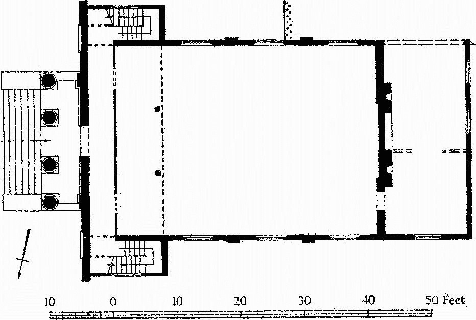
In August 1840, prior to the demolition of the nave, a plan was made of the church showing 'the present position and arrangement of the pews' (Fig. p. 305). This and two watercolours of 1864 (Plate 163) based upon sketches made before the demolition are preserved in the present church of Lady St, Mary; one of the latter shows the interior, from near the W. end of the church, and includes the E. end of the nave with the chancel beyond and the E. part of the N. arcade; the other is a view of the exterior seen from the N.W. The two watercolours give a general impression of the old building, but may not be reliable in matters of detail. The plan is accurate apart from its rectilinearity.
The core of the old church consisted of an aisled nave. The nave measured 64¼ ft. by 25¾ ft., but the original length was probably 61¾ ft., as the E. face of the later tower was set back in relation to the W. walls of the aisles, showing that the gable was demolished when the tower was completed. The aisles were 8¾ ft. wide. The eastern arch was 15¾ ft. wide and of two orders; the inner order sprang from a plain abacus of uncertain profile; the latter is clearly visible in the watercolour only on the S. side, where the W. face is shewn flush with the wall surface, the N. respond of the arch being largely masked by the pulpit and sounding board. The outer order was plain with a slight projection and apparently rectangular in section; it stopped without any finish at the level of or just above the abacus, suggesting that it originally sprang from a return which had been dressed off, possibly to accommodate a late mediaeval rood screen. The N. arcade was of six bays, the arches springing from T-shaped piers, each with a flat face about 4 ft. long towards the nave. The arches varied slightly in width: the first, counting from the E., measured 5 ft.; the second 5¼ ft.; the third 6¼ ft.; the fourth 5¼ ft., and the other two 5½ ft. each. There was a blank stretch of wall 7¾ ft. long at the E. end of the arcade. The S. arcade was very similar with an additional opening 5¼ ft. wide piercing the blank wall at the E. end. The three arches at the E. end of the N. arcade, shown in the view of the interior, were round-headed and of two orders similar to those of the chancel arch; where visible the orders sprang from an abacus of two projecting, square-sectioned members separated by a flat; these abaci were continuous along the nave face of the piers. Above the first and second arches were round-headed windows with wide openings, splayed embrasures and deeply sloping sills; the wall above the third arch was blank; the view of the exterior shows two more clearstorey windows further W. The aisles were divided into bays by cross walls with wide arches springing from the piers and from slight projections from the aisle walls. The only arch visible in the watercolour is that between the second and third bays of the N. aisle; it had a plain round head. Externally the aisle is shewn covered by a pent roof of comparatively low pitch, broken over the third bay by a tall structure with a transverse gabled roof. The outer face of this structure projected slightly beyond the line of the aisle and was treated as a lofty blank arch rising above the eaves of the aisle roof and framing a doorway with a pointed head, apparently of the 13th century. Internally the watercolour shows the aisle wall in this bay splayed back at the level of the eaves, suggesting that the projecting arch and the upper part of the structure were later additions. But the wider opening in the arcade suggests that there was a doorway here from the beginning. There was also a doorway in this position in the S. aisle. No record of its treatment survives, but the plan shews no projections like those on the N. side.
The arcade walls extended beyond the nave with openings about 5 ft. wide immediately E. of the eastern arch. On the S. side this wall continued to where it was cut through by the N.W. angle of St. Edward's Chapel; the floor of this last lies some 3 ft. below that of the church. On the N. side the wall is shewn continuing at the same width for 16 ft. where the transition to the slightly narrower wall of the 14th-century chancel is masked by a buttress. This would give a minimum length of 16 ft. for the choir of the earlier church.
The bays of the N. aisle varied between 7 ft. and 8 ft. in length with the exception of the easternmost which was 10 ft. long. Even so, the aisle was not coextensive in length with the nave. Adjoining on the E. was a separate room with a fireplace and chimney, in 1840 probably used as a vestry; it measured 12¼ ft. by 8¾ ft. and was separated from the aisle by a wall with a doorway towards the outer end; the doorway had a splayed embrasure and must have been late mediaeval. The exterior view shows the masonry and roof of the aisle and the eastern room unbroken, suggesting that the whole fabric was of one date. Even if the wall separating the aisle from the eastern room was not original, the greater size and the anomalous position of the room overlapping the nave and the space to the east suggest a special function. On the S. side of the church the arrangement at the E. end of the aisle had been altered to provide access to St. Edward's Chapel, an addition of c. 1100; the additional opening at the east end of the arcade and the transverse arch spanning the aisle immediately E. of this opening were probably connected with the building or remodelling of this chapel.
The 19th-century watercolour of the exterior shows that the windows in the aisle were renewed at various dates in the 13th, 14th and 15th centuries and that the clearstorey was raised and provided with a battlemented parapet which masked a low-pitched late mediaeval roof. The interior view provides evidence of a considerable rearrangement in the 18th century; the galleries over the aisles projecting into the nave, the pulpit with its sounding board and the coved plaster ceiling are all of this date.
A closer dating of the pre-Conquest church must depend on the parallels that can be cited, interpreted in the light of the known historical development of Wareham. The matter is discussed in the Sectional Preface (Pt. l, p. xliii) in the setting of the general review of pre-Conquest ecclesiastical buildings in S.E. Dorset, but in summary it appears that the early church at Wareham Lady St. Mary should be ascribed to the time of St. Aldhelm (ob. 709), with alterations to the N. porch and possibly also to the corresponding S. porch at more than one date and the remodelling of the E. end of the S. aisle in the early post-Conquest period.
Appendix B
Early Christian Inscriptions (fn. 10) (see also p. 308 and Pt. 1, p. xlix).
The five inscriptions (Plates 165, 166) in the church of Lady St. Mary form a group which must be compared both epigraphically and prosopographically with the early Christian monuments of Wales and the south-west. The earliest of the Wareham inscriptions dates from the 7th century; the latest is of c. 800 or later.
The lettering is a mixture of Roman capitals and of forms derived from contemporary or rather earlier book-hands. In view of the date it has seemed best to describe the latter forms as Insular. In Ireland the Cathach of St. Columba, written soon after the middle of the 6th century, is classed as early Insular majuscule. (fn. 11) Though no contemporary British MSS. survive, the influence of this book-hand can be traced in inscriptions of the early 7th century, such as the Cadfan stone at Llangadwaladr, (fn. 12) and perhaps even earlier. Insular majuscule, a script derived from the half uncial book-hand, (fn. 13) allows an intermingling of uncial forms to an extent that varies from MS. to MS. Attention is drawn to these forms where they occur in the inscriptions.
The names recorded on all, save possibly the last, of these inscriptions find their explanation and parallels in the British material preserved in other Celtic lands. They are only explicable in terms of Celtic philology and the forms used are appropriate to the date ascribed to the stones.
These five stones are memorials originally erected in the cemetery of the Saxon monastery or of the British church which preceded it presumably on the same site. The form of the memorials, namely tall pillar stones with inscriptions generally running vertically downwards, is purely Celtic and is not found in Anglo-Saxon contexts.
Technically the letters are cut in a series of straight lines with a U or V-shaped section. The edges of the channel are blurred, giving an irregular outline. In the line-drawings on Plate 166, dotted restorations are confined to the minimum needed to explain the forms; fractures are shown in cross hatching; a stipple is used to denote abrasion of the surface. The abrasion is often shallow and in places the cutting can be followed across it by touch. The outline of the stone is indicated only where it cuts across an inscription. In the following transcriptions dots on the line indicate letters missing, more or less; subscript dots indicate uncertain letters; dots at mid line indicate stops (cf. Plate 166); letters which, though missing, can be restored are indicated by square brackets.
No. i
VIDCV . . .
FILIVS VIDA . . .
The letters, which vary markedly in size, are Roman capitals with an uncial D and Insular L. The C is square. The final letter in the second line is imperfect; it can only be an A with angular cross bar. The strokes of the C and the Vs are crossed at their junction and several of the letters have prominent forked serifs.
The closest parallels in Britain are the inscription from Llanfihangel Cwmdu, ascribed to the late 6th or early 7th century, (fn. 14) and the St. Peter stone at Whithorn, probably of the late 6th or early 7th century. (fn. 15) Both show the crossed junction of the strokes and the variation in size of the letters. The forked serifs are used more consistently on the St. Peter stone.
The forked serif is widely found in Continental inscriptions of the 6th and 7th centuries. (fn. 16) The square C is characteristic of the same period in Gaulish inscriptions. (fn. 17) The uncial D does not occur in the earliest group of Welsh inscriptions, dating from the 5th to the 7th centuries, though it is found in group II, e.g. at Llanlleonfel. (fn. 18) The Insular L at Llanddewi Brefi may be rather earlier, (fn. 19) but the form is characteristic of group II, from the 7th to the 9th century.
Probably 7th-century.
The first name may well have been VIDCVMI, in the Latin genitive, when the inscription was complete. This would be Old Welsh *Guidcu, modern Welsh Gwyddgu, meaning something like 'well-known dear one' or 'well-known kind one'. The second name could well be VIDAR, if Middle Welsh Gwydar is from an Old Welsh *Guidar (the source and etymology are uncertain).
No. ii
IUDNNE . . .
FIL[I] QUI . . .
The regularly formed letters are mixed Roman capital and Insular forms. The U is angular, almost square. If the reading of the fifth letter in the first line is correct, the uncial and Insular forms of the letter appear side by side; the concurrent use of the two forms is common in Insular majuscule MSS. The last letter in this line is incomplete, with only the rounded back remaining; a capital E of rounded form is likely. The reconstruction of the bases of the letters FIL at the beginning of the second line is conjectural; no trace of the second I of this word remains. A few of the letters have forked serifs (cf. No. i). Both the D and the Q show a slight shallowing of the groove, almost a gap, between the upright and the loop; this feature may be compared with the treatment of the cross arms in a number of Welsh crosses, which there is reason to attribute to the 7th century. (fn. 20)
The closest parallel in Insular epigraphy is the rather later inscription at Llanlleonfel which should belong linguistically to the later 8th century. (fn. 21) Both inscriptions have the same tendency to square letter-forms; both use the Insular N, the Q with a loop and long shaft and the square U. But Llanlleonfel uses the uncial D while Wareham prefers the Insular form. The tendency to separate the different parts of the same letter may also be noted at Llanlleonfel. In Insular epigraphy the forked serif occurs occasionally as late as the early 9th century, e.g. on the Caldey Island stone. (fn. 22) In Wales the square U is found in the latest inscriptions of group I (5th-7th centuries); the Insular N is first used in group II (7th-9th centuries).
Probably late 7th-century.
The first name is clearly one in iud, 'lord', a type well-known in Welsh in e.g. Old Welsh Iudris later Idris, Iudhael later Ithel etc. The only one of this group which seems to fit is Old Welsh Iudnerth, 'one with lordly strength', 'strong like a lord'. The second name, with its qu-, cannot be Welsh, nor is it likely to be Irish at so late a date. It must probably therefore be Latin: perhaps Quintus or Quintilius or the like, though such a name would be quite unexpected at this period.
No. iii
CATGUG . C . . .
FI]LIUS . GIDEO
The letters are irregular and straggling. The forms are generally Insular majuscule, though the A and U and the rounded E are better described as debased Roman capitals. The A in particular is anomalous; it appears to be a reversed example of the capital type with angular cross bar (cf. No. i). The fourth letter in the first line looks as though the workman first cut a T, repeating the previous letter, and then corrected to G. The last letter in this line could be O, but this is unlikely. The first four letters in the second line are cramped, as though the cutter began FI]LI . GIDEO and later inserted the US. The central bar of the rounded E is separate from the rest of the letter (cf. No. ii). There are traces of forked serifs.
The second word in the first line may have been adjectival (fn. 23) or a noun in apposition. (fn. 24)
Some of the Insular forms used in this inscription are found sporadically in the latest Welsh inscriptions of group I, dating from the 5th to 7th century, but they are more usual in group II, beginning in the 7th century. Their more consistent use in this inscription indicates a date after these forms had become established. Welsh inscriptions of this period are not common and it is difficult to suggest a close parallel. The use of stops to separate the words has no chronological significance.
7th to 8th-century.
The first name is the later Welsh Cattwg, and occurs in Old Welsh as Catguc (Book of Llandaff, p. 161). This is a pet-form of the longer name Old Welsh Catguocaun, Catgucaun, Middle Welsh Cadwgawn, i.e. Cadogan, from British Catuvocānos, 'powerful in battle' or 'glorious in battle'. The C which follows cannot of course be interpreted; it is possibly the first letter of some adjectival epithet. The punctuation point seems to prevent reading Catgugc, where gc would have represented a hesitation over how to write the final consonant, not unnatural in the circumstances. Gideo is doubtless the Biblical Gideon.
Biblical names occur occasionally on early Christian Celtic inscriptions. (fn. 25)
No. iv
D]ENIEL . FI[LIUS
... AUPRIT . IA[CET
The letters, which are straggling and disparate, shew a mixture of Roman capitals and Insular forms. There is no trace of the initial D. Two forms of capital E are used in the first name. The last surviving letter in the first line is probably FI ligatured, as the end of the cross bar is beginning to drop; the upright of the F projects above the looped upper bar. The first mark in the second line is the tail of an oblique stroke; it is difficult to explain this except as the end of an uncial A, a form used occasionally in Insular majuscule MSS., or an Insular R together with the more normal letter. The beginning of an A can also be distinguished at the end of this line, much disguised by the surface abrasion of the stone. Forked serifs occur on a number of letters, but there is no consistent use of them. The words are separated by stops (cf. No. iii).
It is difficult to point to a close parallel to this inscription. The straggling layout and the mixture of letter forms point to a late place in the series. The forked serifs, though more common in the 7th century, continue to occur in the early 9th (cf. No. ii).
8th-century, perhaps rather late.
Deniel is early Welsh for Daniel, in Middle Welsh Deinioel. At this date Denioil might perhaps have been expected, but the e would still very likely be possible, if only as a rather outdated spelling. The name Auprit (if the first letter is really A) is unknown, and even with more letters at the beginning it suggests no known name. It looks like a compound in prit, Middle Welsh pryt, 'shape', 'form'.
No. v
GONGORIE .
A fracture almost obliterates the fourth letter and damages the fifth. The small central fragment has been slightly displaced so that the fifth letter reads badly. There is a final stop.
The letters are Insular majuscule with a Roman capital E. The N is adapted from the uncial form, which is used in some Insular MSS. together with the more normal N. Several of the letters are characterised by an extension to the left of the tops of the uprights; this feature is particularly noticeable in the N, where the tops of both uprights are so treated.
Letters of the same general character are found in the 8th-century inscription at Towyn, (fn. 26) though the forms are there less exaggerated and the setting out more irregular. The forked serif to the central bar of the E is uncertain as the surface is here abraded.
8th to 9th-century.
This is evidently the Latin genitive of a woman's name, Gongoria, presumably an Old Welsh *Gongor when deLatinised, but no such name appears to be known. The Old Welsh Guncar of the Book of Llandaff, p. 157, is a man's name, and even if it were a woman's would still be rather far from Gongor.
(2) The Church of St. Martin (600 yds. N.N.W.) (Plates 169, 170) has walls of rubble with ashlar dressings and the roofs are covered with stone slates and some tiling. The Chancel and Nave are pre-Conquest, of the 11th century; in the last quarter of the 12th century part of the N. wall of the nave was demolished and rebuilt with an arcade of two bays opening to a new North Aisle; late in the 15th century the W. ends of the nave and the N. aisle were rebuilt. The level of the chancel roof has also been lowered. The South Tower is of the 16th century, restored and with the top rebuilt in 1712. In the 18th century the church fell into disuse, but it was restored in 1935–6.
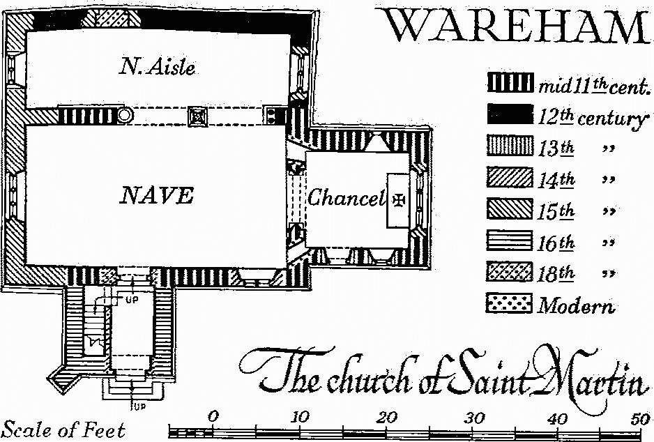
Wareham, the Church of Saint Martin
The church has considerable interest as a building of the first half of the 11th century. It contains a series of wall paintings of which the earliest are probably of the 12th century.
Architectural Description—The Chancel (12 ft. by 11 ft.) has walls of rubble with large squared quoins, in part of long and short work, above an ashlar base with a chamfered plinth; in the E. wall is a mid 15th-century window of three cinque-foiled lights with vertical tracery in a two-centred head with a label with returned stops; the mullions have been restored. The N. wall has an original window of one small round-headed light. In the S. wall is an original window widened in the late 13th century and a late 13th-century doorway with chamfered jambs and restored two-centred head. The chancel arch is semicircular and of a single chamfered order with a bold, roll moulding on the soffit; it springs from chamfered imposts returned round the moulding which continues down the square responds to a chamfered plinth; the N. impost is continued to meet the N. wall of the nave but the continuation of the S. impost has been cut away; the arch has a half-round label on the W. also partly cut away.
The Nave (30 ft. by 16½ ft.) has a plain modern squint N. of the chancel arch. S. of the chancel arch a round-headed recess was formed early in the 12th century to provide the setting presumably for the reredos of an altar; the rough surface of the wall below the recess shows whence the altar has been removed. It was probably one of a pair of altars flanking the chancel arch, but no corresponding recess was made on the N. side. The S. recess itself was modified, if not blocked, in the 14th century for the insertion of a niche and in modern times it has been pierced for a square-headed squint. The N. arcade has two plain round arches; the E. respond has two Purbeck marble shafts with a common base, partly cut away, and with carved stiff-leaf capitals of early form conjoined at the top under a common abacus. The central pier has a square capital with similar stiff-leaf carving at each corner; the original pier had four detached corner shafts but was replaced in the late 18th century by a new pier with attached polygonal corner shafts and a hollow-chamfered base which rests on the original chamfered plinth. The original base survives loose in the N. aisle. The W. respond has a capital only of the late 12th century; it rests on the W. impost of an 11th-century doorway which has been cut into to take the respond shafts, but these have been removed; of the doorway there remains the plain W. jamb, the impost, part of the W. segment of a round tympanum and, on the N., part of a label; abutting the label is a length of chamfered string-course. The S. wall is of the 11th century to the E. of the W. wall of the tower; to the W. of the same it is of the 15th century. The window is of c. 1330 and has two ogee trefoiled lights and a curvilinear quatrefoil; the doorway was partly rebuilt in the 18th century but the rough W. impost and W. springing of the original round head is visible in the stairway of the tower. The W. window of the nave is of the mid 15th century and has three trefoiled lights in a moulded square head.
The North Aisle (8½ ft. wide) has in the E. wall a mid 15th-century window of two cinque-foiled lights with vertical tracery in a two-centred head. The N. wall has been patched and some of the patching may represent the blocking of a former window; toward the W. end is a blocked doorway of which the chamfered jambs are visible externally and the segmental-pointed rear arch is outlined in the plaster internally; it is probably of the 15th century. In the S. wall, W. of the arcade, now internal but originally external, the 11th-century plinth of the nave survives. In the W. wall is a 16th-century window of two square-headed lights with a label.
The Tower (8 ft. square) is of two stages with gables to N. and S. The lower part forms an entrance porch and has a round-headed doorway in the S. wall over which is a recessed panel inscribed 'Richard Coole Edward Benet Chorch Ward Ans 1712'; in the upper part of the ground stage is a small rectangular loop-light to the S. The second stage has a small round-headed window to the E. and, at a higher level, small square-headed windows to the E., S. and W. and a doorway to the N. leading to the nave roof; in the S. gable is a further small window.
Roofs: the chancel roof is modern; the nave roof has been rebuilt with some old timbers incorporated; the 16th-century aisle roof has cambered tie beams and slanting struts to the principal rafters, now boxed in, and longitudinal braces to the purlin.
Fittings—Bell: one, by Clement Tosiear, 1698. Brackets: In N. aisle, flanking E. window, two moulded stone brackets, 15th-century; over W. respond of arcade, reset chamfered corbel, probably to carry an earlier roof. Chair: in nave, with moulded and enriched framing and arms and panelled back, c. 1650, with inscribed plate 'Given by Elizabeth wife of Charles Oldfield Bartlett 1842'. Consecration Crosses: in chancel, on N. wall, (1) painted in red on ochre ground; in nave, on N. wall, W. of arcade, (2) uniform with (1), late 12th-century. Font: set against W. respond of N. arcade, octagonal bowl inscribed 'Set up by William Welsted and Philip Helliar 1607'. Graffito: in chancel, on W. jamb of S. doorway, perhaps 'Adam', 15th-century. Inscription: see under Architectural Description above, Tower. Monument and Floor-slab. Monument: in N. aisle, to T. E. Lawrence, 1935, recumbent effigy in Purbeck stone by Eric Kennington, R.A. Floor-slab: in N. aisle, to Robert Carruthers R.N., 1799, Isabella his wife, 1786, and their infant children (see Paintings below). Niche: in nave, in E. wall, S. of chancel arch, shallow recess with trefoiled round head, chamfered jambs and shelf cut back flush with wall, 14th-century.
Paintings: In chancel—on rear arch of E. window, an indented pattern in red and ochre and, in N.E. corner, on E. wall roses and on N. wall I.H.S. with crown, 15th-century; on N. wall, the window is outlined with a red band continued to divide the W. part of the wall into two heights; in lower height is a scene with horsemen, in upper a second scene with horsemen of which the top was destroyed when the wall was lowered; E. of window and on W. splay of window are traces of further figures, 12th-century; overlying parts of the 12th-century work are traces of masonry lining with scroll ornament and a band of lozenge pattern, 13th-century; round chancel arch, masonry lining and conventional scroll ornament, 13th-century, and, above, remains of panel with black-letter inscription, c. 1600. In nave—on E. wall, remains of a pattern of stars, early 15th-century; on N. extension of impost, indented pattern, 12th-century, overpainted in 13th century; on chancel arch, black-letter inscription 'Le[t e]very lawe [be] subject unto a higher power f[or th]ere is no power but of [God] Rom' (xiii, 1), and to each side of arch parts of the Decalogue within a border, c. 1600; higher up, and overlying much of the earlier work, an achievement of the Royal Arms dated 1713 flanked by a further painting of the Decalogue divided into two parts, each within a border; on N. arcade, masonry lining, 13th-century; over N. arcade, a large painted inscription in memory of Mr. Robert Carruthers, superannuated surgeon R.N. and 'practitioner in this borough', 1799, Isabella his wife, 1796 (sic), and Capt. Ned Carruthers R.M. drowned in H.M.S. Invincible, 1801 (see Floor-slab above); on W. respond of arcade and W. end of N. wall, fragments of texts of 16th, 17th and 18th centuries; on S. wall, the Creed, early 18th-century; on W. wall, fragment of a black-letter inscription, late 15th-century. In N. aisle—on N. side of E. respond of arcade, masonry lining and foliation, early 13th-century. Royal Arms: see under Paintings above. Miscellanea: in N. aisle, lying loose, stone fragments including base of pier of N. arcade, late 12th-century, and ridge-piece with socket for gable cross and four-sided bowl for piscina, mediaeval.
(3) The Church of the Holy Trinity, South Street, has walls of rubble and roofs covered with slates and stone slates. The Chancel and Nave were built in the 14th century, with a two-bay arcade opening into a North Chapel. The West Tower was built in the 16th century. In the 17th century the E. wall was rebuilt, and in the 18th century a very plain stone structure replaced the former N. chapel; the W. end of it has since been rebuilt. The South Porch is modern.
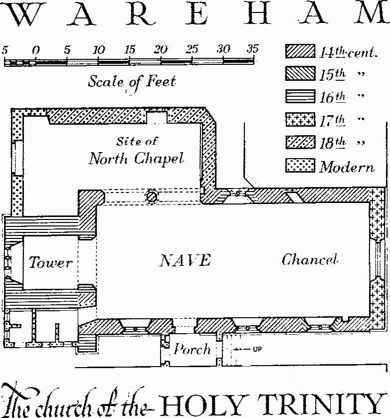
Wareham, the Church of the Holy Trinity
Architectural Description—The Chancel and Nave (44 ft. by 16½ ft.) are structurally undivided. The E. wall has a chamfered plinth and a window with two-centred head and moulded 14th-century rear arch, now without any mullions or tracery. The N. wall has a house built against the E. part; a squint in this part of the wall is blocked. Further W. is a 16th-century window of two square-headed lights above another squint, also blocked. In the W. part of the wall is a two-bay arcade with octagonal pier with moulded cap and chamfered base; the E. arch has been replaced by a hollow-chamfered segmental arch of c. 1500. The original W. arch is two-centred and of two moulded orders; the responds are chamfered. In the S. wall the E. window is of the 15th century and has two ogee cinque-foiled lights with pierced spandrels in a square head under a label with small returned stops. The two other windows are of the 14th century; each has two cinque-foiled lights with sunk spandrels in a square head under a label also with small returned stops. The doorway has a moulded two-centred head with continuous jambs and a chamfered segmental rear arch.
On the site of the North Chapel is a rough lean-to building without any architectural features.
The West Tower (8½ ft. square) is of two stages divided by a moulded string-course and has a chamfered plinth, moulded parapet string and plain parapet surmounted by obelisks. The tower arch has a chamfered round head above plain jambs. The W. window has three square-headed lights. In the upper stage are single-light windows to N., S. and W. with four-centred heads within square outer mouldings. The Porch is modern but contains a reset mediaeval archway with moulded segmental head and continuous jambs.
The Roof of the chancel and nave is ceiled with a plaster barrel vault divided by plain chamfered ribs into three bays each of four panels above chamfered wall plates.
Fittings—Bell: one, no inscription. Bracket: on E. respond of arcade, moulded shelf on tapered corbel, 15th-century. Font: see Monument (1), Lady St. Mary's church, Font (2). Piscinae: in chancel, (1) with cinque-foiled head and sunk spandrels within a square moulding, and with drain holes round a central knob, 14th-century; in E. respond of N. arcade, (2) with trefoiled head and with projecting eight-lobed drain partly cut away, 15th-century. Recess: in porch, reset sevenfoiled head, perhaps of a stoup, over modern shelf, mediaeval.
(4) Congregational Chapel, Church Street (170 yds. N.), with brick walls partly rendered in stucco and a tiled roof with stone slates at the verges, is a rebuilding of 1762. It replaces the 'Presbyterian Meeting-house' which, according to Hutchins (1, 81), was destroyed in the great fire of that year. In 1860 and 1895 wings were added to N.W. and S.W., the former to accommodate the Sunday School. A single-storey porch (not shown on the accompanying plan) extending across the W. front of the chapel was built in the late 19th century. The recess in the E. wall is modern.
The Congregational Chapel
The chapel is nearly square; the W. front has two plain doorways and segmental-headed windows with radial glazingbars. Inside, the roof, which is in three parts, is supported by six timber columns with Tuscan capitals. The columns also support the panelled fronts of the N., S. and W. galleries. The ceiling over the central space is coved and divided into square panels by pine ribs; the gallery ceilings are flat and similarly divided and conceal plain triangulated trusses.
Fittings—Seating: in gallery, early 19th-century, except, over staircases, small box-pews, probably 18th-century.
(5) Unitarian Chapel, South Street (Plate 179), has walls of brick with the E. front rendered in stucco and the roof covered with slates. It was opened in October 1830 (D.C.C. 7 Oct. 1830) to serve a congregation which seceded from the Congregational community in Church Street in 1828 (Hutchins I, 119).
Unitarian Chapel
The E. front has steps leading up to a central entrance portico of four Ionic columns carrying a simple entablature of which the upper part is carried across the full width of the elevation; over the portico is a panelled parapet; to each side of the portico is a round-headed niche in the wing walls that screen the staircase projections to N. and S. In the other walls are round-headed windows. The entrance leads into a vestibule the full width of the chapel with a staircase in a wing at each end giving access to an E. gallery carried on slender timber columns. The pulpit is at the centre of the W. end of the chapel, and behind it are two small rooms now thrown into one. The chapel is ceiled with a segmental plaster barrel vault.
Fittings—Organ: lower part of case with solid panels, upper part three bays of pipes, centre bay flanked by Ionic pilasters with pediment, c. 1830. Pulpit: with arcaded cornice, 1830, remodelled. Seating: incorporated into later seating are three doors from original pews. Staircases: with turned newels, 1830.
(6) Former Congregational Chapel, West Street, now a school, is of brick with the S. end rendered and has a low-pitched slated roof. It was built by George Gollop of Poole and John Swetland and opened on 1st January 1790 (W. Densham and J. Ogle, Congregational Churches of Dorset (1899)). It was built to serve a congregation which seceded from the Congregational community in Church Street in 1789. After their reconciliation in 1849, the chapel was converted and enlarged for use by the British School, founded in 1830, formerly in Church Street.
The E. and W. walls of the original building survive but the S. front was rebuilt c. 1849. The S. elevation is rendered and divided into three bays by panelled pilasters under a pediment; it has a central doorway and two heights of segmental-headed windows. The interior comprises a large room (45½ ft. by 30 ft.), formerly with a gallery at the S. end but now devoid of any original fittings, and a smaller room to the N. Reset inside the front boundary wall is an early 19th-century pedimented wall-monument of stone with sarcophagus-shaped inscription tablet and urn.
Secular
(7) Town Hall, on the site of the former church of St. Peter, is a modern building but has reset in the S. wall of the Council Chamber an achievement of the Royal Arms of William III with lion and unicorn supporters and the motto of Nassau Je Maintiendray, all carved in high relief, painted and gilded (Plate 60). The arms are incorrectly presented, England filling the first quarter and France modern the fourth. Below is a small plaque with inscription 'Let mercy goe wit justice ano 1656'.
Borough Seal (Plate 36), of silver with ivory handle, bears the shield-of-arms of the borough within a circular border inscribed Sigillum Villae & Burgi De Wareham; the stem is inscribed 'Ex dono Michaell Derby'; 17th-century. Mace (Plate 38), of silver, parcel gilt, 23¼ ins. long, is of the early 17th century; at intervals along the stem are knops enriched with bands of cable moulding; the flanges are formed by eight beasts joined to the stem at the feet and shoulders and decorated with strapwork; the seal-shaped end is inscribed 'HH mayor 1615', for Henry Harrison. The plain cup-shaped end of the mace has a flat top enriched with bands of moulding within which has been set a shield of the Stuart royal arms with date and initials '1660 C 2D R'.
(8) North Bridge, over the R. Piddle or Trent, of stone, has three arches; the N. arch is pointed and may be of mediaeval origin; the middle and S. arches are segmental and were probably rebuilt c. 1670 following orders made at the Quarter Sessions of 1667 and 1670; contracts were made in 1670 with John Maskell and John Thorne and with Robert Slade and Thomas Godden. The bridge was widened to the W. and the approaches improved in 1846 to the plans of George Evans, County Surveyor, the work being carried out by Dominic Stone of Taunton. There are cutwaters on the piers of the arches on the W. side only; the parapets are modern.
Wareham Lady St. Mary
The South Bridge is modern, but see Wareham St. Martin (1).
Railway Station and Gatekeepers' Cottages, see pp. 416–7.
(9) Almshouses, East Street, of two storeys with walls of brick and roof covered with stone slates, originally founded by John Streche who died in 1418, were rebuilt in 1741 and have been modernised internally.
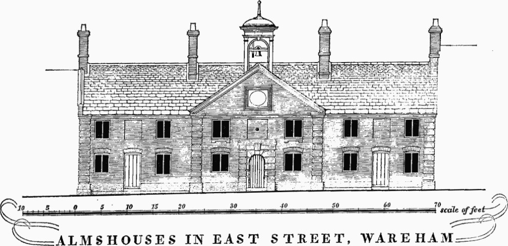
Almshouses in East Street, Wareham
The N. front is in three main bays divided and flanked by rusticated pilaster-like quoins; the middle bay projects slightly under a pedimented gable containing an inscription panel and surmounted by a timber cupola. The central entrance doorway has a semicircular head and is set in a recess with rustications to each side under a simplified entablature. In each side bay is a plain doorway between two windows. Over the doorways are blind recesses ranging with the first-floor windows. At the back the centre has the upper floor carried forward on four iron columns between side wings.
(10) Christmas Close, hospital (918874), was built as a Workhouse under the Poor Law Amendment Act of 1834; the land, in Christmas Close, was bought in 1836 and Messrs. Carter and Hyde were appointed as architects to supervise the erection of the building later in the same year (Minute Book of the Wareham and Purbeck Board of Guardians, D.C.R.O.).
The building is of three storeys with brick walls and slated roof and is built on a standard plan comprising an octagonal block and four radiating wings (cf. Dorchester 18, Poole 22, Weymouth 16); it is very plain, with hung sash windows, only the S. end of the S. block being given a slightly more elaborate architectural treatment.
(11) House, Priory of Lady St. Mary, is of two storeys with lower ranges round a courtyard to the N.; the walls are of stone rubble with some rebuilding and additions in brick and the roofs are covered with tiles with stone slates at the verges.
A priory was founded here in the early 12th century as a cell of the Norman Abbey of Lire, perhaps on the site of an early monastery mentioned in A.D. 876; on the suppression of alien houses in 1414 the priory was bestowed on Henry V's new Carthusian foundation at Sheen (V.C.H., Dorset II, 121). The present house dates from the early 16th century; the main E. part of the S. range comprised a single-storey hall with parlour with chamber above to the E.; the service end to the W. was largely rebuilt in the 18th century. Beyond it are the ruined remains of an undercroft perhaps of the early 17th century, and an L-shaped building N. and E. of the courtyard is also of this date but was much altered in the 19th century and later; the longer W. arm is built above an undercroft. In the late 17th century the hall was divided into two storeys and at a later date the N. elevation was remodelled to give a symmetrical front now partly masked by a 19th-century entrance passage. Later in the 18th century a coach house, now incorporated with the drawing room, was built against the S.E. corner of the house and the building N. of the courtyard extended to the W. In the late 19th century a further wing was built N.W. of the service quarters.
The house has been much altered but the main features of the 16th-century layout can still be traced.
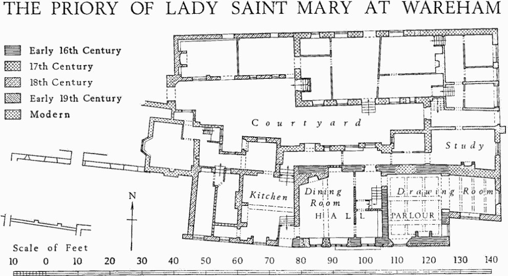
The Priory of Lady Saint Mary at Wareham
Architectural Description—South Elevation. The S. wall of the former hall is of rubble, partly with a battered plinth; the walling has been disturbed where buttresses have been removed. The ground floor has three windows of which the two-light window to the E. is original and formed the lower part of a taller transomed window of which the upper part except for the chamfered E. jamb has been largely destroyed; the chamfered W. jamb of a similar window appears above the westernmost window. The two W. windows date from the late 17th century when a floor was inserted into the hall; one was reduced to two lights and both sills were lowered in the 19th century. The first-floor windows above now have modern casements. To the E. the walling is of rough Purbeck ashlar with a chamfered plinth, perhaps an 18th-century refacing, and none of the openings is original. To the W. the service end has been rebuilt in brick but the stone jambs of the original S. doorway remain with one chamfered jamb of an original window above. The North Elevation has part of the lower storey masked by the later entrance passage; the walling is of rubble with a 17th-century doorway, now internal, reset in the 18th century between two 18th-century windows which are now blocked; the doorway has a moulded four-centred stone head and continuous jambs. The doorway to the kitchen, also now internal, has a timber frame with four-centred head, which has been reset. The small gabled wing N. of the kitchen has in the W. wall a similar but smaller reset timber door-frame. The lower ranges of the building to the N. have been much altered but retain three original 17th-century doorways with moulded four-centred stone heads and continuous jambs; the undercroft of the N. range is lit by small looplights with chamfered jambs and lintels.
The former Hall was divided into two storeys in the late 17th century; it has an 18th-century chimneybreast in the N.W. corner and a staircase of c. 1730 in the N.E.; the original balusters of the staircase have been replaced by modern metalwork. The Drawing Room to the E. has the ceiling divided into panels by moulded intersecting beams; the fireplace has a moulded four-centred stone head with carved spandrels and embattled cresting. The Study in the E. range has a smaller reset fireplace similar to the last but without the cresting. The Undercroft of the N. range has in the N. wall a series of plain stone corbels to carry the beams supporting the original upper floor. The Roofs are of the 18th century and later.
W. of the main part of the house are the remains of an undercroft with the walls standing a few feet high; in the N. wall is a regular series of narrow looplights.
Barn to S.W., probably of 16th-century origin, has been partly rebuilt and the roof renewed.
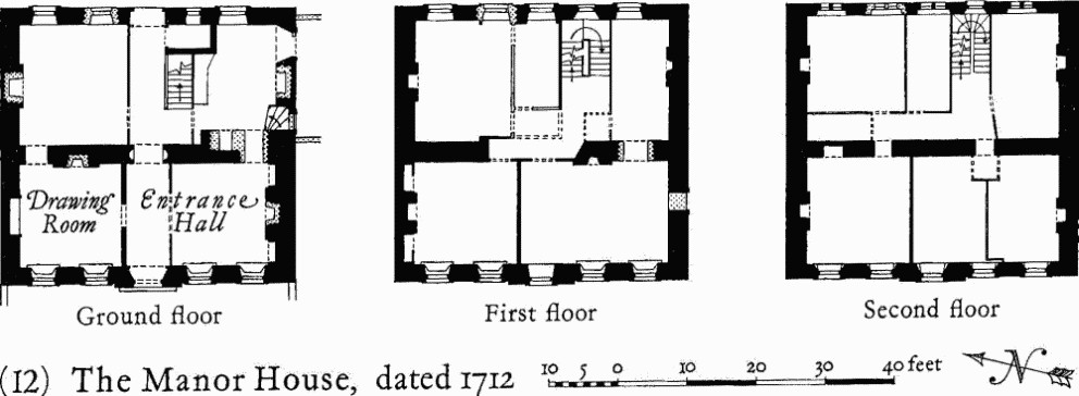
The Manor House, Dated 1712
(12) The Manor House, South Street (Plate 173), is of three storeys with the front wall of ashlar and other walls of brick with stone dressings and has an original flat roof covered with lead; this is dated 1712 with the inscription 'This platform was cast by James Gaylard plumber for Mr. George Gould'.
The house has a dignified front of finely-wrought ashlar and retains most of the original fittings.
The W. front has a moulded plinth, plat-bands between the storeys, rusticated quoins, dentil cornice, and parapet divided by pilasters into bays of solid walling and open balustrading. The middle bay forms a centrepiece of slight projection with a doorway flanked by fluted obelisks within a moulded architrave with shaped top cutting into a pulvinated frieze under a bowed pediment. The windows have beaded architraves and those on the upper floors have moulded aprons; some retain the original heavy glazing bars. The back elevation has stone architraves to the doorway and windows; there are circular windows to the staircase and additional modern windows further N. Inside, the entrance hall, now divided to give a separate room to the S., is lined with ovolo-moulded and fielded panelling; a panelled archway with niches in the reveals (Plate 174) leads to the rear hall; the fireplace surround is modern but includes 17th-century carved woodwork from elsewhere. The drawing room is lined with bolection-moulded panelling with a cupboard (Plate 174) in the N. wall with shouldered and enriched architrave under a shaped pediment. The staircase has the lower flight altered; from first to second floor it has a cut string, fluted columns as newels and twisted balusters and, from the second floor to the roof, a close string and turned balusters. On the first floor two rooms have original fireplace surrounds.
Monuments (13–78)
The following monuments, unless otherwise described, are of two storeys, many with an attic, with walls of brick, often on a stone plinth and finished with an oversailing brick eaves cornice, and with roofs covered with tiles, often with stone slates at the verges; they are of the late 18th century. Most of the houses near the centre of the town have the ground floors modernised as shops with modern display windows; a number of them have lost 18th-century doorcases and bay windows very recently.
Church Lane
(13) House, No. 1, of one storey and attic, with cob walls and thatched roof, is probably of the early 18th century but has been thoroughly modernised.
Cow Lane
(14) Houses, Nos. 18–28 (even), are of the early 19th century; they are built in pale brown brickwork with casement windows.
(15) House, No. 34, of one storey and attic with cob walls and thatched roof, may be of 17th-century origin.
East Street
N. side
(16) Houses, Nos. 1, 3, and The Duke of Wellington p.h., are built largely of rubble with some brickwork. Nos. 1 and 3 have small rectangular bay windows.
(17) Houses, Nos. 15, 17, of the early 19th century and with slated roofs, have reeded timber door-surrounds; No. 17 has a bow window and a second doorway under a common cornice.
(18) House, No. 27, has the front elevation built in Flemish bond with red stretchers and blue headers and includes a smaller building added on the W. side in the early 19th century.
(19) House, No. 29, was refronted in the third quarter of the 19th century.
(20) Houses, Nos. 37, 39, form a long low range of one storey and attic; the lower part of the walls is of rubble and the upper part covered with pebble dash; they are of 17th-century origin largely rebuilt.
S. side
(21) House, No. 6, has the ground floor of rubble and is of the early 19th century. It has a bow window flanked by pilasters.
(22) House, No. 14, has a bay window with curved sides.
(23) House, No. 18, has walls of cob on a stone base; it was built c. 1700 but has been much altered and converted into two small tenements opening off a through passage.
(24) House, No. 20, has a bay window with curved sides.
(25) Chichester House, No. 38, is of the early 19th century. The front is in three bays, the middle one projecting as a part octagon; the doorway is flanked by reeded pilasters with a fanlight rising into an open pediment.
(26) Cottages, Nos. 40, 42, with cob walls and thatched roof, are of 17th-century origin and were partly rebuilt in the early 18th century. (Demolished)
Mill Lane
(27) Store, former Working Men's Institute, has some of the lower parts of the walls of rubble perhaps of the 17th century, but it was built up in brick as a warehouse in the late 18th or early 19th century.
North Street
W. side
(28) House, No. 1, is fronted in Flemish bond with red headers and brown stretchers and a plat-band at first-floor level. The doorway has attached reeded columns with Doric frieze and open pediment over a dummy fanlight. The dormer windows have cheek-boards decorated with scrolls and zigzags.
(29) House, No. 3, has a plat-band at first-floor level.(Demolished)
(30) House, No. 5, has a moulded and enriched timber eaves cornice with modillions. The doorway has a flat hood carried on shaped brackets with a lozenge between them. (Hood removed)
(31) House, No. 7, has the front elevation rendered; the doorway has a flat hood on shaped brackets and there is a bay window with rounded ends.
(32) Houses, Nos. 11, 13, a pair, are fronted in red brick laid in header bond with vertical panels of vitrified headers between the windows; the doorways have reeded pilasters and flat hoods carried on shaped brackets; the doorway to No. 13 has been moved and a two-storey bay window added.
(33) Anglebury, house, Nos. 15, 17, with rubble walls and roof covered with stone slates and tiles, is of the 16th century, but the front was remodelled with new windows and eaves cornice in the 18th century; at the N. end is a lower wing fronting on Cow Lane; the main block was built on a three-room plan with a central hall, with a through passage at the N. end of it, and smaller rooms at each end of the block. The staircase N. of the hall chimney is partly of the early 18th century and may be in the position of the original staircase. The back wing has been partly rebuilt and there are later additions S. of it.
(34) Houses, Nos. 29, 31, a pair, with slated roof, are of the second quarter of the 19th century; the doorways are placed together centrally and have elliptical heads with moulded imposts beneath an outer ogee arch.
(35) House, No. 33, with stone walls and thatched roof, may be of 17th-century origin but was remodelled in the early 19th century.
(36) King's Arms p.h. has a thatched roof.
(37) Houses, Nos. 43–53 (odd) are of the early 19th century; Nos. 45 to 51 are of three storeys with a parapet and have doorways flanked by moulded timber pilasters carrying open pediments, those of Nos. 47 and 49 being united under a common pediment; the doorway to No. 53 is similar.
(38) Houses, Nos. 55, 57, 59, are very plain and are of the early 19th century; mid 19th-century bay windows have been added.
(39) Houses, Nos. 65, 67, 73, 75, 77, are of the first half of the 19th century and built in pale brown brickwork.
E. side
(40) Houses, Nos. 14, 14a, have rubble walls with additions in brick and slate-covered roofs. No. 14 was built c. 1600 and No. 14a soon afterwards. Both houses were drastically altered c. 1840 and probably at the same time they were combined to form one dwelling.
No. 14 is L-shaped on plan brought up to a square by a 19th-century addition; the front wall retains some traces of the original window openings and has been heightened in brick; in the back wing is an original doorway with chamfered stone jambs and rounded head; the roof retains original collar-beam trusses. No. 14a consists, on the ground floor, of a wide entrance passage and a single room separated by a muntin and plank partition; in the E. wall of the room is an original doorway, now blocked, with rounded head; the fireplace at the S. end has been partly reconstructed and originally had a newel stair at the side of it.
(41) House, No. 16, of three storeys with a slated roof, has rendered walls of which the two lower storeys are thick and said to be of cob. The house was heightened and remodelled in the first half of the 19th century but the chimneys in the back wall suggest that it may be of the late 16th century. A two-storey wing at the back, partly of stone rubble, is of various dates; the E. end may originally have been a freestanding outbuilding.
The W. front has an entrance doorway near the centre and hung-sash windows asymmetrically arranged. The doorway has a reeded surround and panelled door of the 19th century, set within an older door-case comprising narrow side pilasters, console brackets and cornice with segmental pediment, probably early 18th-century. The interior has been extensively refitted but retains a good open well staircase of the early 19th century, rising from the entrance hall to the top storey. Each floor has a large room to the N. and a smaller one to the S.; the upper rooms to the N. have fireplaces in the N. end wall but the original chimneys appear to have been two on the E. wall.
(42) Houses, Nos. 36, 38, 40, are of the late 18th or early 19th century. No. 36 was probably built as an extension to No. 38; it has been completely modernised. No. 38 has a symmetrical front with central entrance leading to an internal porch in one end of the larger of the two front rooms. No. 40 has a door-case with pediment, and a bow window.
(43) House, No. 54, of three storeys, is of the early 18th century, remodelled in the early 19th century; the central doorway has a semicircular fanlight, reeded pilasters and open pediment.
The Quay
(44) House, No. 2, has the front built in header bond; all the windows are modern.
(45) House, No. 3, Warehouse and Cottage, No. 4 Church Green, are grouped at the N.E. corner of the Quay. The house, mainly of rubble, was heightened and remodelled in brickwork in the 18th century; the front is stuccoed. The cottage, forming a back wing to the house, has the lower part of rubble; reset in the brick upper part is an old ridge-stone inscribed W.D. 1845. The warehouse, of brick and rubble with stuccoed front, was built probably as a dwelling in the early 18th century and has one window retaining an original moulded architrave.
(46) New Inn, of brick and rubble, with rendered front, has been extensively modernised.
St. John's Hill
(47) Smithy, with rubble walls partly rebuilt in brick and roof covered with stone slates and tiles, was probably built as a barn c. 1500. An original doorway has wave-moulded four-centred head and continuous jambs; the roof is modern.
(48) House, Nos. 4, 5, was built probably in the early 18th century on a three-room and through-passage plan.
(49) House, No. 1 Gold Court, is traditionally reputed to stand on the site of a Saxon Mint; under the house is a cellar with stone walls and a brick barrel vault.
(50) Houses, two, and Horse and Groom p.h. are of the early 19th century. The E. house has a two-storey bay window and central doorway flanked by pilasters carrying an open pediment.
South Street
E. side
(51) Houses, Nos. 15, 17, were built c. 1700 and remodelled in the late 18th century. At the S. end is an original chimney-stack with panelled sides.
(52) House, No. 21, has walls of rubble and roof covered with stone slates and tiles; it is of 17th-century origin but was rebuilt, except for the roof, c. 1950.
W. side
House, No. 2, see Monument (60).
(53) Houses, Nos. 4, 6, 8. Nos. 6 and 8 are rendered and No. 8 has an added parapet.
(54) House, No. 12, has a plat-band at first-floor level and an early 19th-century doorway and bowed shop window framed by pilasters and with a re-curved crowning cornice, concave over the doorway, convex over the window (Plate 171).
(55) Black Bear Hotel (Plate 173) is of three storeys with rendered walls and balustraded parapet; the central entrance with later porch is flanked by three-storey bow windows.
(56) House, No. 16, has the front finished with cornice and parapet.
(57) Houses, Nos. 18–28 (even), are of the first half of the 18th century.
(58) House, Nos. 30, 32, has walls of rubble and roof covered with stone slates and tiles; it was built c. 1600 and a later wing has been added at the back. On plan the house originally consisted of three rooms with an axial chimney at the S. end of the central hall. The building has been much altered and the N. end divided off and converted into a shop.
Trinity Lane
(59) The Rectory is L-shaped on plan and has an 18th-century range running E.–W. and an early 19th-century wing to the S. with an entrance porch in the re-entrant angle. The doorway has a reeded architrave carried over a semicircular fanlight.
Reset in the garden wall is a 12th-century archway with round head enriched with chevron ornament, perhaps from the Castle (Monument 80).
West Street
S. side
(60) Houses, Nos. 1, 3, 5, and No. 2 South Street (Plate 171), are of one build; the walls are of red brick with dressings of white brick and there is an attic storey in a mansard roof. No. 2 has a small bow window under a square cornice; the sill is supported on a curved wrought-iron bar.
(61) House, No. 7, has the front built in English bond brickwork with white dressings.
(62) Houses, Nos. 9, 11, have the front rendered and a mansard roof. The entrance to No. 9 has an original pedimented door-case. (Doorcase removed)
(63) Antelope Hotel has the front built in header bond; the entrance has an original hood carried on shaped brackets.
(64) Houses, Nos. 15, 17, 19, 21. No. 15 is rendered and has a parapet. No. 17 has the front built in header bond with a plastered plat-band and parapet. No. 19 has a plat-band. No. 21 has a 19th-century butcher's shop-front with external meat rails carried on elaborate wrought-iron brackets.
(65) Houses, Nos. 23, 25 (Plate 41), were remodelled in the early 19th century, probably to convert a single dwelling into two. No. 23 has an entrance doorway with semicircular fanlight under an entablature which is continued over a bow window; the doorway and the window are flanked by narrow panelled pilasters. To the E. is a later bay window. The entrance doorway to No. 25 has reeded side pilasters and an open pediment of free Doric style over a semicircular fanlight.(Front modernised)
(66) House, No. 27, is faced with vitrified headers with red dressings. The entrance has moulded architrave and hood.
(67) Houses, Nos. 37, 39, were built in the early 19th century; No. 39 was originally two dwellings.
(68) Houses, Nos. 41, 43, are of the early 19th century. No. 41 has an original bow window and entrance flanked by moulded pilasters under a common cornice.
(69) Cottage, No. 53, of one storey and attic with cob walls, has, on plan, a single room opening off a through passage. (Demolished)
N. side
(70) Red Lion Hotel was advertised as 'newly built within these 20 years' in the Salisbury Journal 7 July 1783, but it includes some earlier walling in the cellars and some of the stonework in the plinth is reused; an extension to the W. is little later than the main building. The S. front is faced with white headers with red dressings and is symmetrically designed with end pilasters and central doorway with traceried fanlight flanked by fluted timber pilasters carrying a frieze with triglyphs and open pediment. The W. extension is faced with red headers and has round-headed windows. The frontage on North Street is faced with light brown brick with red dressings and has a doorway with reeded side pilasters and a pediment; at the N. end is a carriage entrance with elliptical arched head with plain imposts and keystone. The interior has been modernised but retains an original staircase with turned balusters, except on the top landing which has a trellis balustrade; some of the rooms also retain original ceiling cornices.
The Bar at the W. end is of a separate build with walls in Flemish bond with brown stretchers and blue headers.
(71) Houses, Nos. 2, 4, a pair, with rendered walls, are of c. 1800. No. 4 retains the original entrance doorway with reeded pilasters, Doric frieze and open pediment over a semi-circular fanlight with foliated tracery.
(72) House, No. 6, has the front faced with red brick with darker red dressings carried up to a rebuilt parapet above a moulded brick cornice; at first-floor level is a moulded platband. The central doorway has a moulded timber architrave and flat hood carried on shaped brackets; to the E. is a mid 19th-century shop window of three pointed lights.
(Front modernised)
(73) House, No. 12, is fronted in header bond, with a platband to the middle part. It has two early 19th-century bowed shop windows flanking a shop doorway with house doorway to one side, all separated by thin reeded pilasters, under a continuous cornice curved on plan and similar to that of Monument (54) (Plate 171).
(74) Houses, Nos. 18, 20, were built at the beginning of the 19th century; bay windows were added in the mid 19th century and No. 18 was refronted c. 1960.
(75) St. Michael's, house, is faced in red brick with contrasting dressings. The central doorway is flanked by fluted timber pilasters and has a dummy fanlight rising into an open pediment. The double-hung sash windows have segmental arched heads in gauged brickwork with keystones; two of the original windows have been replaced by an early 19th-century bow window. The N. end is partly of rubble; the back elevation has windows irregularly placed.
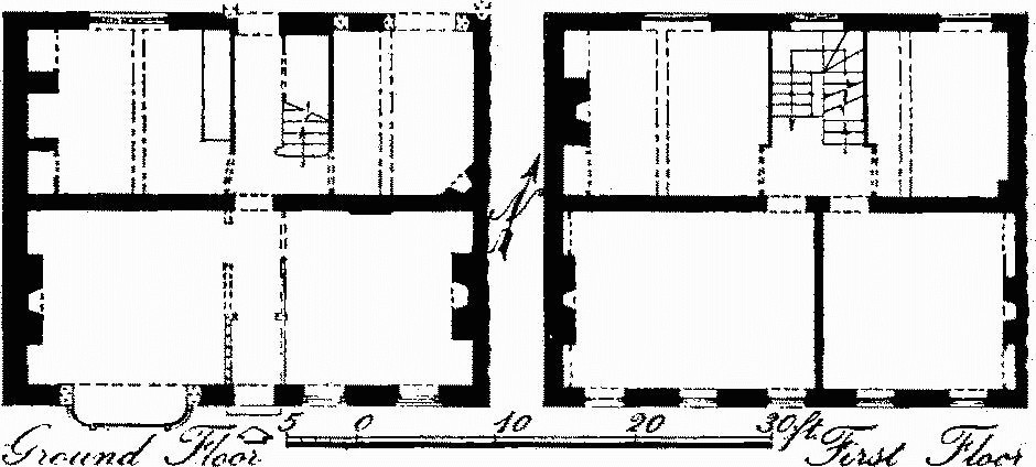
St. Michael's
On plan the house is generally similar to Monument (12), the entrance passage widening at the back, beyond an elliptical archway, to take a staircase with cut string and turned newels and balusters. The ground floor was partly refitted in the early 19th century but retains some original panelling and, in the N.W. room, an original fitted kitchen dresser. The first floor retains two original fireplaces and a panelled dado.
(76) Houses, Nos. 28, 30, 32 and Nos. 34, 36, 38, are of the late 18th or early 19th century.
(77) Pure Drop p.h., No. 46, and Houses, Nos. 48–56 (even), are of the early 19th century. No. 48 has a doorway with reeded pilasters and an open pediment over a blind semicircular fanlight; Nos. 50 and 52 are roofed with modern pantiles, No. 54 with slates.
(78) Mill House, 120 yds. W. of St. Martin's Church, has walls partly of rubble and was built c. 1700 on a two-room plan with a chimney at one end.
Earthworks, Etc.
Mediaeval and Later Earthworks
(79) Town Defences (Plate 172). Wareham is mentioned in 876 in the account of the war between King Alfred and the Danes. The vernacular version in the Anglo-Saxon Chronicle states that: 'In this year the enemy army slipped past the army of the West Saxons into Wareham.' It goes on to record how Alfred made peace with the Danes, exacting hostages and oaths, and how under cover of the negotiations the mounted men stole away by night to Exeter (Anglo-Saxon Chronicle, ed. Dorothy Whitelock (1961), sub anno). Aethelweard in the Latin version adds some details; he states that the Danes came from Cambridge and joined forces with the western army near the town ('iuxta oppidum') called Wareham and that they devastated the great part of the province (H. Petrie, Monumenta historica britannica, I, 515). Asser's account states that the Danes entered into the strong place ('castellum'), which is called Wareham. He adds a number of local details, doubtless from personal observation, for Wareham was an important church in his diocese of Sherborne. Asser became bishop of Sherborne not earlier than 892 and wrote his life of King Alfred after that date. His description may reflect the conditions of his own day and his use of the word 'castellum' need not therefore prove the existence of defences in 876 (Asser, De rebus gestis Regis Aelfredi, ed. W. H. Stevenson (1959 imp.), cap. 49). Wareham is included in the list of fortresses defending the frontiers of Wessex known as the Burghal Hidage. This list, which was drawn up under Edward the Elder and probably between 910 and 919, represents the full development of the system established by King Alfred and his successor; there is good reason to believe that its outline was laid down by King Alfred in the years preceding the Danish invasion of 892. In the Burghal Hidage 1600 hides are allocated to the maintenance and defence of Wareham, sufficient according to the annexed document to support ramparts measuring 2200 yards, a figure which approximates very closely to the length of the banks enclosing the town on the W., N. and E. sides (A. J. Robertson, Anglo Saxon Charters (1939), 246–9).
The site of Wareham is an almost level terrace of river gravel over Bagshot Beds, between about 10 ft. and 38 ft. above O.D., at the place where the rivers Piddle and Frome come closest together before diverging to enter Poole Harbour 1¼ miles E. The town covers a roughly square area of about 91 acres. The earthwork defences surrounding it on the N., E. and W. sides are known as the 'Walls'; the S. side is bounded by the river Frome. The West Walls were scarped against attack by tanks in 1940.
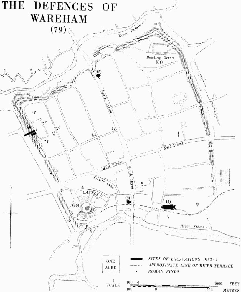
The Defences of Wareham
Excavation, observations, and chance finds provide evidence of Iron Age occupation on the site and more widespread evidence of Roman settlement (see Part 3, p. 614). A stone fragment of a large Classical architrave reused for a 7th-century inscription (see Monument (1), under Fittings, Inscriptions: No. i), may imply at least one stone building of especial architectural distinction here in the Roman period.
In 1952–4, the Commission conducted excavations on the West Walls (Med. Arch. III (1959), 120–38). The defences were judged to date from the reign of King Alfred, with the addition of a stone wall in the late 10th or 11th century and the recutting of the ditch in the 12th century.
The town had four main entrances more or less central in the sides, taking roads roughly E.–W. and N.–S. through the defences. Widening has destroyed any remains of the original arrangements, though where North Street now runs up a steep cutting with incurving scarps on either side Hutchins saw 'two very large bastions' (Hutchins I, 77–80, 94–5). A gap in the N. side between this cutting and the N.W. angle is probably later; so too are other gaps in the defences on the E. and W. at the ends of lanes.
On the W. the line of the defences, which commences at the bank of the Frome and runs N.W. for 585 yds., is notably straighter than elsewhere. Apart from a rough mound just S. of West Street and slight traces suggesting a flattened rampart 100 yds. S. of it, only a ditch 50 ft. to 70 ft. wide and 13 ft. deep survives in the S. part. The suggestion of a counterscarp bank commencing 50 yds. from the S. end of this side is probably due to the scarping of the irregular edge of the river terrace by later tracks, one of which runs into the ditch at this point. N. of West Street the rampart survives but the ditch is only traceable towards the N.W. corner, though no doubt it continued S. for the whole length before the present parallel road was constructed. The N. part of the ditch had been partly dug into a gully dropping N. through the natural scarp above the river Piddle (Plate 172). The upper part of the rampart has been thrown into the ditch for a distance of 160 yds. N. of West Street and the internal height of about 15 ft. thereby reduced to 12 ft. Where the rampart is best preserved it is 12 ft. high above the interior and 26 ft. above the bottom of the ditch, this last being 55 ft. wide. About 30 ft. W. of the ditch a scarp rises steeply W. Only the slightest fall is now detectable beyond it and this feature is mostly natural in origin; it may be this that Hutchins described as an 'outer rampart much defaced'.
In the Commission's excavations the rampart and ditch were sectioned completely in one place; the rampart alone was sectioned in two others and tested at a fourth point (for positions, see Fig. p. 323). Late Iron Age storage pits and Roman occupation material, including New Forest wares of the late 3rd or 4th century, were sealed by a rampart over 9 ft. high and 47 ft. wide, perhaps revetted externally with timber (later scarping had removed the face, but P.S., see Pt. 1, p. lxx). It consisted mostly of sand and gravel apparently coming from an external ditch, of which all traces had been removed by later recutting. The black earth containing occupation material which comprised the upper layers seemed to have been derived from behind the rampart where a depression indicating some quarrying was visible in the section. This had already been suggested by observations of a pipe trench cut c. 1930 just to the N. of the Commission excavation (C. D. Drew, Dorset Procs. LII (1930), lxxxvii-viii), but an observer of a nearby pipe trench cut in 1953 noted that there was no internal quarrying at that point (R. A. H. Farrar, Dorset Procs. LXXVIII (1956), 77–8). After some time had elapsed a layer of river loam 4 ft. thick was added to the rear of the rampart and a stone wall was erected on the crest. The latter had a mortar raft to support footings at least 7 ft. wide, and a footpath of sand and clay 15 ft. wide ran behind it. A mortar flange waterproofed the outer edges of the wall footing. Subsequently the wall was thoroughly robbed down to its foundations, a flat-bottomed ditch was dug 30 ft. wide and 18 ft. deep, and some of the material from it dumped on top of the rampart.
At the N.W. corner of the defences the rampart is 15 ft. high measured from the inside. The natural surface tilts W. to the gully already mentioned but the rampart was built up to the same height as elsewhere. Externally it drops 19 ft. to a shelf where there are traces of damaged scarps described by Warne as 'platforms with low breastworks' (C. Warne, Ancient Dorset (1872), 86). There is a suggestion of quarrying on the inside but no sign of an external ditch,
The N. rampart of the town, 670 yds. long, follows an irregular line along the scarp; there was presumably no ditch on this side, but a natural ledge is visible at the junction of the rampart and the river terrace. Where best preserved the rampart is 64 ft. wide, set 30 ft. to 40 ft. above the river Piddle and 12 ft. high above the interior. The N.E. corner is again massive with damaged scarps below it.
The E. rampart of the town, 760 yds. long, in four straight alignments, has an interior height of about 8 ft. and a width of 60 ft. The southern 120 yds. have been virtually destroyed. An excavation in c. 1910 revealed evidence suggestive of a stone wall within the rampart (Drew, loc. cit.). A road at the foot of the scarp has largely obscured the ditch. A low broad bank, with a ditch to the E., can be traced some 20 yds E. of the E. rampart for three-quarters of its length (in Wareham St. Martin parish). Since it is not precisely parallel to the main defences and has been almost completely levelled, and since evidence for its date is lacking, its relation to other remains is uncertain. On the N. it first appears on the edge of marshy ground. The best preserved remains can be seen just N. of the edge of the river terrace as a spread bank 80 ft. across, 2 ft. high inside and still 3¼ ft. above the ditch bottom, with a broken-down counterscarp a further 45 ft. to the E.
There is no trace of defences on the S. side of the town where it borders the river Frome. (R.A.F. V.A.P. CPE/UK 1821: 6402–4.)
(80) Wareham Castle (Plate 172, Fig. p. 323), earthworks and buried structures, lies in the S.W. angle of the town defences (see Monument 79), where the modern house, Castle Close, stands on a flat-topped mound overlooking the river Frome (92188718). The mound, the castle motte, has a total diameter of 250 ft. and is 120 ft. across the top. The dimensions and appearance probably owe much to relatively recent work, and especially to the building of the house. Hutchins' plan (Hutchins I, opp. 77) suggests that in the late 18th century the top of the mound was only 55 ft. across. It was surrounded by a ditch, now mostly filled in, but best preserved to the S.S.W. where it is now about 70 ft. across and 22 ft. deep below the top of the mound; slight traces of the ditch can also be seen to the N. and W. of the mound. Beyond the ditch on the N. and N.E. sides the curve of the W. part of West Street and of Trinity Lane probably indicates the line of the bailey. Some reused stonework, including a small Norman arch in the Rectory wall (see Monument 59), is the only other visible trace of the castle. However, massive stone foundations have been discovered at points along the probable line of the bailey (H. J. S. Clark, Dorset Procs. LXXII (1950), 99–110), and excavations by Mr. Clark during 1952–3 have shown that the base of a stone keep survives inside the mound (D. F. Renn, in Med. Arch. IV (1960), 56–68). Much 12th-century pottery was found in the excavation, and the small finds included horse-shoes, an arrowhead and a crossbow detent. About half of the area of the keep is covered by the present house.
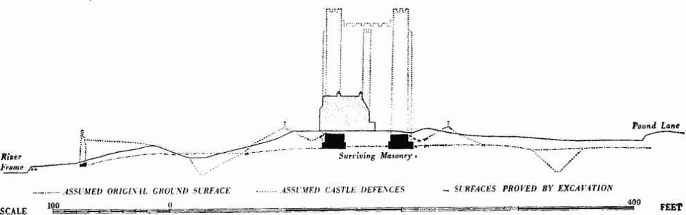
Wareham Castle
The early history of Wareham castle is difficult to determine since the early documentary references are confused by the description of Corfe castle as Wareham castle (see Corfe Castle (10)), but the fact that the town was a fortified royal borough and was at an early date an important harbour leads to the supposition that there may have been a castle here soon after the Conquest. (fn. 27) Nothing even of the earthworks is demonstrably of this period. The imprisonment of Robert of Belesme at Wareham in 1113 recorded in the Anglo-Saxon Chronicle (fn. 28) may indeed refer to Wareham, though a confusion with Corfe is possible. The castle figures prominently in the events of 1138–42. (fn. 29) The date of its destruction is unknown.
The small square rubble-built keep with pilaster buttresses at the angles and in the centre of each side and with quoins of large squared blocks of alternating limestone and sandstone belongs to a type that is likely to be of the early 12th century; in the absence of surviving detail a closer dating is not possible.
The keep was 37 ft. square internally with walls 13 ft. thick. The latter were set on foundations with an offset externally of 3 ft. 1 in. and internally of 9 ins. to 1 ft. The foundations, located at five points, were set 4 ft. into the gravel and were of undressed stones, including sandstone, chalk, limestone and Purbeck marble boulders. The upper surface of the exterior offset sloped slightly outwards. Above this the walls were of rubble with large squared quoins alternately of grey Purbeck limestone and brown sandstone. The diagonal tooling was well preserved and the mortar joints were wide. In the core were found reused stones with mortar adhering, as well as chalk blocks, quartz and granite pebbles, and pieces of greenish slate ascribed to deposits in Normandy. At one point a sherd of scratch-marked pottery was embedded in the mortar. This walling ended abruptly at a height of 6 ft. in a level surface of mortar, above which survived a few courses of rubble walling with poor sandy mortar and including reused dressed blocks.
Above the foundation offset the walls were strengthened with pilaster-buttresses. Central buttresses, found on two sides of the keep, were 8 ft. wide and projected 2 ft. Those at the two angles uncovered were 11 ft. wide with a projection of 2 ft. and were set back 2 ft. on either side of the angle.
The excavations also revealed on the N. side dark earthy material piled up against the outer face of the keep to a height of 4½ ft., covering the offset and the dressed facing stones; above it was a layer dating from after the destruction of the keep, having boulders lying on and just below the surface. From a distance of 12 ft. N. of the keep, strata in all 10 ft. thick were seen to tilt upwards towards it.
Sections across the curving bank beyond the ditch S. and S.W. of the mound showed that 6 ft. of rubble lay above the natural ground surface. This bank could be part of the original W. town defence, later altered to run S. to the river, but its smallness, the rubble and spread nature of it and its fall to the E. make this unlikely. Further S. still, 68 yds. from the keep, a wall 5 ft. thick, believed to be part of the curtain wall of the castle, was sectioned. It was of rubble with dressed ashlar faces showing diagonal tooling and with a pilaster buttress on the inside (information from H.J. S. Clark). Fragments of walling 13 yds. further S. may be remains of a fish weir (Dorset Procs. LXXII (1950), 99). (R.A.F. V.A.P. CPE/UK 1821: 6402–4.)
(81) The Bowling Green (92458780; Fig. p. 323), probably a post-mediaeval enclosure, lies in the N.E. corner of the town. It is rectangular with an almost flat interior, approximately 180 ft. (E.–W.) by 90 ft., surrounded by a low bank about 12 ft. wide with an external ditch 6 ft. wide and now 1¾ ft. below the crest of the bank. Traces of gaps at the E. and W. ends suggest entrances; a ramped causeway leads to the E. entrance from the summit of the town rampart. The N.E. corner of the enclosure clearly lies over the tail of the town bank. It could perhaps have been constructed as part of a pleasure garden (Dorset Procs. LXIV (1942), 92–110), and a brick tower, 'Dugdale's Folly', once stood W. of it. Fairs were held here in the 18th century and it is shown on surveys of 1762 though not on those of 1746 (J.B.A.A. XIV (1908), 22).
Other Earthworks and Allied Monuments
(82–4) Round Barrows, p. 455
Linear Dyke, see Arne (48), p. 516
(85) Roman Remains, p. 614