An Inventory of the Historical Monuments in Dorset, Volume 2, South east. Originally published by Her Majesty's Stationery Office, London, 1970.
This free content was digitised by double rekeying. All rights reserved.
'Coombe Keynes', in An Inventory of the Historical Monuments in Dorset, Volume 2, South east(London, 1970), British History Online https://www.british-history.ac.uk/rchme/dorset/vol2/pp49-52 [accessed 30 April 2025].
'Coombe Keynes', in An Inventory of the Historical Monuments in Dorset, Volume 2, South east(London, 1970), British History Online, accessed April 30, 2025, https://www.british-history.ac.uk/rchme/dorset/vol2/pp49-52.
"Coombe Keynes". An Inventory of the Historical Monuments in Dorset, Volume 2, South east. (London, 1970), British History Online. Web. 30 April 2025. https://www.british-history.ac.uk/rchme/dorset/vol2/pp49-52.
In this section
10 COOMBE KEYNES (8484)
(O.S. 6 ins. aSY 88 SW, bSY 88 NW, cSY 88 SE, dSY 88 NE)
The parish of Coombe Keynes, covering about 2,000 acres, lies 5½ m. S.W. of Wareham; the greater part of it comprises a roughly rectangular block, mainly on Chalk, sloping N. from about 400 ft. to 150 ft. above O.D. and cut into by steep-sided dry valleys. In the E. the Chalk is overlaid by Reading Beds and by London Clay giving rise to a well-wooded rolling landscape between 250 ft. and 150 ft. To the N.E. is a narrow projection of the parish, on Bagshot Beds giving an almost flat heathland at just under 100 ft. above O.D. The present village, and original settlement, lies at the junction of the Chalk and Reading Beds in the middle of the parish; extensive earthworks indicate that it was once somewhat larger. The church is largely rebuilt but retains a notable pre-Reformation chalice. All the buildings earlier than the late 18th century are in or close to the village, almost certainly because of the existence of at least parts of the former open fields round it until that time (Map of Coombe Farm, 1770, D.C.R.O.). The heathland in the N.E. of the parish was all enclosed in 1761 (Map and Award, D.C.R.O.; see also Map of Coombe Keynes new enclosures, 1770, D.C.R.O.).
The most notable structure is North Lodges, one of the entrances to Lulworth Park in the adjoining parish (see Lulworth, East, Monument 3).
Ecclesiastical
a(1) The Parish Church of the Holy Rood stands 100 yds. S. of the present village. The walls are of carstone, local limestone rubble and knapped flint with limestone dressings; the roofs are covered with stone slates. It was built in the 13th century but only the chancel arch and the West Tower remain of that date, and they are much restored. The Chancel and Nave were rebuilt in 1860, and the North Porch is of the same date, all by John Hicks (Building News, vii (1861), 734).
The church possesses an important English chalice of c. 1500, now on long loan to the Victoria and Albert Museum, London; only seventy-eight English mediaeval chalices are known to survive.
Architectural Description—The Chancel (22 ft. by 13 ft.) has lancet windows in the 13th-century style. The restored 13th-century chancel arch is two-centred and of two chamfered orders, the outer continuous and the inner springing from engaged shafts with moulded capitals and chamfered bases.
The Nave (41 ft. by 18 ft.) is entirely of 1860, with lancet windows similar to those in the chancel.
The West Tower (8 ft. square) is of a single stage externally and of two storeys internally; on the angles are 19th-century clasping buttresses, and the roof of the same age is pyramidal. In the E. wall is a 13th-century doorway with plain two-centred head, chamfered jambs with shaped stops at the springing and a segmental-pointed rear arch; above the doorway is a single-light window to the nave with two-centred opening, splayed reveals and elliptical rear arch. The window in the W. wall consists of a restored single lancet light. The belfry has an original tall single lancet with stone louvres in the W. wall and 19th-century windows of the same design in the N. and S. walls.
Fittings—Bells: three; 1st, by Thomas Hey, inscribed 'Angelus. Michael. Maria. Gabriel', 14th-century; 2nd, by Anthony Bond, 1636; 3rd, by John Wallis, 1599. Coffin-lids: In churchyard—N. of W. tower, (1) hollow-chamfered and tapering, (2) small, with cross on calvary, much worn, (3) small, tapering, with cross and shaft, much worn and broken, all early 14th-century. Font: stone hemispherical lead-lined bowl with square rim and boldly moulded necking, 13th-century, on modern drum pedestal and chamfered base.
Monument and Floor-slabs. Monument: In churchyard, E. of chancel, headstone with inscription now illegible, 17th-century. Floor-slabs: In nave, (1) to Jane the wife of Samuel Serrell, 1719; (2) to Samuel Serrell, 1722; (3) to Mary Allner, 1729, and Anna Bewnel her granddaughter, 1787; (4) to Anna (Allner), wife of James Bewnel, sen., 1755; (5) to Elizabeth Bewnel, 1753, and Ann Joyce her widowed sister, 1787; (6) to Mary Bewnel, 1755, and her sister Martha, wife of Thomas Robinson, 1787; (7) to James Allner and his son, dates illegible; (8) to James Bewnel, sen., 1755/6.
Plate: includes chalice (Plate 22) of c. 1500 and stand-paten of 1726; the chalice of silver, parcel-gilt, with rounded bowl, hexagonal stem with knop and flared hexagonal foot, the knot with six embossed spirally twisted and traceried lobes ending in crowned angels' heads, the foot with one facet engraved with the Crucifixion and the moulded base concave-sided, reeded and with pierced foliations at the corners, height 63/8 ins. Miscellanea: Reset in base of outer face of W. wall of tower, length of moulded string, mediaeval, and two plain gable crosses.
Secular
North Lodges and Clare Towers, on the S. boundary of the parish, see Lulworth, East, Monument (3), p. 149.
a(2) Old Rectory (close N.), of one and two storeys, was built in cob in the early 19th century, extended W. in brick later in the first half of that century and again subsequently in similar material; the last extension is slate-covered, the remainder thatched. The original block is almost symmetrical on plan with a central passage and stair. The N. elevation has a doorway with a trelliswork porch with flared roof and flanked by three-sided bay windows. The three upper windows are half dormers, with casements containing leaded quarries. Inside, the staircase has plain square balusters and a moulded newel.
a(3) House (150 yds. N.), of two storeys, of rubble and with a thatched roof, was built in the late 16th or early 17th century. It has been extended and so considerably altered that the original plan is uncertain. It probably comprised two rooms, each with a fireplace in the end wall, divided from one another by a through passage. Two rooms were added at the E. end in the 18th century. Reset in the S. wall of the adjoining Barn are four 12th-century moulded stone dressings.
a(4) Cottages, four (120 yds. N.), on the E. side of Church Lane, of two storeys, of rubble and with thatched roofs, are early Victorian. They form a range with a symmetrical front; the openings have dressings of red and blue bricks, and the windows have sliding sashes.
a(5) House (120 yds. N.), on the W. side of Church Lane, is of one storey and attics. The walls are of cob and the roof is thatched. It was built in the 17th century and refaced and divided into two cottages in the early 19th century.
a(6) House (165 yds. N.N.W.), of two storeys with rubble walls and a slated roof, is L-shaped on plan; the E. block, which represents the principal part of the present house, is early Victorian; the W. wing, now dairies etc. but formerly the dwelling house, is of the 17th century. The walls to the ground floor of the E. block are mostly of reused limestone ashlar and may incorporate parts of an older building on the site, though two reset pieces of tracery may be from Bindon Abbey; the walls above are of carstone rubble. The house was originally of one storey and attics and of limestone rubble; the earliest features in it are the ovolo-moulded ceiling beams, assignable to the mid 17th century; the S. wall was refaced in brickwork in English bond probably in the late 17th century, and the whole heightened in cob in the 19th century.
Barn, N.E. of the house, of cob with a slated roof, has stepped brick buttresses of the 18th century; the latter are the earliest datable features, but the main fabric may antedate them. The walls have been refaced partly in rubble and partly in brick in the late 19th century. It was originally of five bays; the present roof is modern.
a(7) House, opposite (6) on the S. side of the road, of two storeys, with cob walls and a thatched roof, is of the early 18th century. It has a central chimney and two heated rooms on the ground floor.
a(8) Cottage (570 yds. E.N.E.), at Kimbert's End, is of one storey with attics and of cob with a thatched roof. It was built in the early 19th century.
c(9) Kennel Farm, house (852837), of brick and with a tiled roof, is of the late 18th century. It has a symmetrical front with segmental-headed doorway and windows. Barn, N.E. of the house, of rubble faced with brick and with a tiled roof, is contemporary with the house. The roof trusses have principal rafters and collar beams.
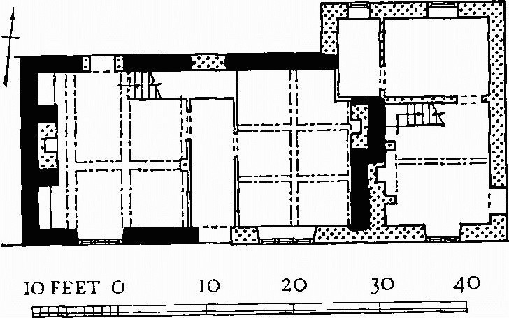
a(10) Barn (500 yds. N.W.) is of cob and with a thatched roof. It was built in the 18th century. The porch is on the N. side. The only original roof trusses, which flank the entrance bay, have slightly incurved principal rafters and cambered collars. In recent times brick buttresses have been added and the W. half of the S. wall has been rebuilt. (Plan p. lxvi.)
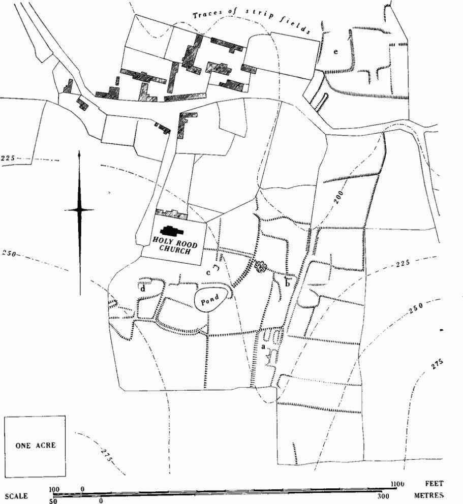
Coombe Keynes. (12) Settlement remains.
a(11) Barn (840832), of brick and with a tiled roof, is of the first half of the 18th century. The porch is on the E. side. The gables at each end are finished with copings composed of shaped bricks.
Earthworks, Etc.
Mediaeval and Later Earthworks
a(12) Settlement Remains, of part of Coombe Keynes village (84508430 to 84208395; plan, p. 51), cover 20 acres of pasture N.E., E. and S. of the church.
The Hearth Tax returns of 1662–4 give only fourteen taxable householders in the village (C. A. F. Meekings, Dorset Hearth Tax Assessments (1951), 79). An estate map by J. Sparrow (D.C.R.O.; Plate 71), prepared for E. Weld in 1770, shows that most of the site had been abandoned by then. Some of the earthworks noted below were hedged (e.g. most of those E. of the hollowway, forming several enclosures all marked 'South Close', and parts of those N. of the road). In the area S. of the church, 'Court Close', only the prominent pond is shown. The arrangement of surviving parts of two open fields N. and S. of the village is also clear. The evidence of the Hearth Tax returns and this map suggest that abandonment here was early and perhaps mediaeval.
Most of the remains lie S. of the present road where a hollow-way follows the narrow valley bottom. Closes on the slope E. of the hollow-way are much cut into by shallow quarrying. Probable house sites lie W. of it. At (a), three approximately level oblong areas are cut into the gentle slope: the two on the N. are 9 ft. to 12 ft. by 45 ft.; that on the S. is 15 ft. by 55 ft. but much disturbed. To S. and W. are almost level scarped platforms above a scarp to the W., 10 ft. high and largely natural. At (b), 60 yds. N. of (a), is a low-banked rounded oblong enclosure, about 25 ft. by 9 ft., with a gap in the S.E. side; the interior slopes E. at an angle of 3½°.
Among earthworks S. of the church are a mound 2 ft. high and a platform (d), perhaps a house site, 40 ft. by 12 ft., openended on the W. and cut into a gentle slope. At (c) are two disturbed platforms among irregularities which might indicate or conceal other house sites. Immediately S.W. of the pond the closes are bounded by a curving ditch or hollow-way which, before the pond was made, might have continued the line of a substantial bank up to 4 ft. high running on the shoulder of the slope N.E. of the pond.
On the widening valley floor N. of the road and E. of East Farm a bank marks the E. and S. sides of an enclosure (e) open to the N.; at the S.E. angle it is 2 ft. high on the outside and 3½ ft. high inside. The ground rises gently W. from the E. bank and becomes very wet. (R.A.F. V.A.P. CPE/UK 1821: 4425 etc.)
Other Earthworks and Allied Monuments
(13–20) Round Barrows, p. 442.
(21) Roman Remains, p. 596.