An Inventory of the Historical Monuments in Dorset, Volume 4, North. Originally published by Her Majesty's Stationery Office, London, 1972.
This free content was digitised by double rekeying. All rights reserved.
'Ashmore', in An Inventory of the Historical Monuments in Dorset, Volume 4, North, (London, 1972) pp. 1-3. British History Online https://www.british-history.ac.uk/rchme/dorset/vol4/pp1-3 [accessed 23 April 2024]
In this section
AN INVENTORY OF THE ANCIENT AND HISTORICAL MONUMENTS IN NORTH DORSET
Arranged by Parishes
The group of four figures following each parish heading gives the position of the parish church on the National Grid, permitting easy location of the place on the one-inch O.S. map at the end of the volume. The next line indicates the sheets of the six-inch O.S. map (edition of 1960) which relate to the parish. Each Monument in the Inventory is located by a six or eight-figure reference to the National Grid.
In architectural descriptions of churches, the parts of the building are taken in the order E. to W. and N. to S.; in descriptions of houses the exterior precedes the interior. Architectural plans have a uniform scale of 24 ft. to the inch, except for a few key-plans at approximately 48 ft. to the inch. Hatching symbols used to indicate dating are uniform throughout the volume. All construction since 1850 is termed modern.
Information now impossible to verify and derived from literary sources, usually Hutchins, is enclosed in square brackets. The date given in the description of a funerary monument is that of the death of the person first commemorated; if known, the date of erection of the monument is added; surnames in round brackets are maiden names. The final volume of the Dorset Inventory will contain a general Armorial of the County.
'Celtic' Field Groups are described extra-parochially in a separate section (see p. 118); Roman Roads will be dealt with as a whole in the final volume of the Dorset series. These exceptions apart, the Monuments of North Dorset are listed below, under the names of the thirty-four Civil Parishes in which they occur.
1 ASHMORE (9117)
(O.S. 6 ins. ST 91 NW, ST 81 NE
Ashmore, covering some 2,700 acres, lies entirely on Chalk above which in the S. and S.E. are extensive areas of Clay-with-flints. The land slopes down from 856 ft. above sea-level on Ashmore Down, at the N. corner of the parish, to less than 400 ft. in the S., dry valleys draining S. and S.W. into Stubhampton Bottom on the W. boundary. Extensive woods in the W. and S. are part of Cranborne Chase. The village (Plate 32) occupies a high spur between two of the valleys, at an altitude of 700 ft.; it is centred upon and takes its name from a large pond, rarely dry and probably the main reason for settlement; the situation resembles that of several Romano-British sites in the area (O. G. S. Crawford, Antiquity, II (1928), 184). The open fields, finally enclosed in 1859, lay around the village; until recently most of the land beyond the area of the fields was open down and woodland. Well Bottom, a small settlement in the S.E., appears to have existed in 1333 ; it lies beyond the former open fields and probably is secondary to Ashmore. In the E. of the parish, cutting through a pre-existing linear ditch, a well-preserved stretch of Roman road leads towards Badbury Rings. (E. W. Watson, Ashmore, Co. Dorset, A History of the Parish, Gloucester, 1890.)
Ecclesiastical
(1) The Parish Church of St. Nicholas was rebuilt in 1874. A two-centred archway of two plain orders with continuous jambs, opening into the N. vestry from the E. end of the N. aisle in the rebuilt church, is said to be the old chancel arch, reset. The arch may be of the 13th century, but since Hutchins (III, 370) says that the former chancel arch did not correspond with its piers, the responds must be of 1874. Fittings from the old church are incorporated in the present building.
Fittings—Chest: for registers, of cast-iron with panelled sides and top, early 19th century. Communion Table: of oak, with turned legs and moulded rails with chip-carving, 17th century. Font: with hemispherical bowl, stout baluster-shaped stem and round convex base, 18th century.
Monuments and Floor-slabs. Monuments: Reset in vestry, (1) of Rev. George Chisholm, 1825, marble wall tablet with painted shield-of-arms; (2) of Elizabeth (Cary) Barber, 1738, baroque wall-monument with cherub-heads and drapery surround, surmounted by shield-of-arms. In churchyard, immediately S. of chancel, (3) of George Barber, 1662, stone slab with shield-of-arms; adjacent, (4) probably of Elizabeth Barber, 1738, stone slab. Floor-slabs: In N. aisle, leaning against wall, (1) of John Mullens, 16 .., broken and defaced. Reset as threshold at entry to vestry, (2) of [John Ca]rver, [1753], Purbeck marble slab with bold lettering, preserved in part.
Plate: includes Elizabethan silver cup and cover-paten (Plate 25), with assay-marks of 1576, cover-paten inscribed 1577. Royal Arms: painted on wood panel, in moulded surround, by K. Wilmot, 1816.
Secular
(2) School (91321783), of one storey, with rubble and ashlar walls and slated roofs, was built in 1842. The original range has modern additions on the N.E. and S.W.
(3) Old Rectory (91301774), of two storeys, has walls of flint and rubble with ashlar dressings, and tiled roofs; it is of early 18th-century origin, with later enlargements and alterations. The N. front is symmetrical and of five bays; in the lower story an original doorway is flanked by coupled sashed windows of c. 1870, with chamfered jambs and segmental heads; in the upper storey are corresponding square-headed sashed windows. The doorway has a moulded stone architrave and a segmental broken pediment on scroll consoles. Inside, the plan is of class T. The staircase and chimneypieces are of c. 1870 or later, except for a chimneypiece of c. 1750 which has recently been brought from elsewhere.
(4) Manor Farm (91051779), house, of two storeys with attics, has walls of ashlar and of squared rubble, and tile-covered roofs. The S.W. range is of uncertain date; the walls are up to 4 ft. in thickness and might be mediaeval, but there is no other feature to confirm this assessment; the unusual thickness of masonry could be the result of refacing a rubble or cob structure with ashlar. The demolition of Eastbury, c. 1782, must have made worked stone readily available locally. The S.W. front is two-storeyed and of four bays, with plain sashed windows and with a square-headed doorway; first-floor level is marked by a weathered string-course. The gabled S.E. elevation has a similar string-course and, at the base of the gable, an ornamental corbel-table similar to that of the archway in the stable court at Eastbury (Plate 80). Projecting N.E. at the N.W. end of the range is an addition of c. 1800, originally built as a Wesleyan meeting room (F. Lyle Uppleby, Ashmore (1949), 8). Some rooms in the S.W. range have chamfered beams, probably of the 17th century.
(5) Cottage (91311778), of one storey with an attic, has walls of banded flint and rubble, and a thatched roof; probably it is of the 17th century. Inside, a large open fire-place has a chamfered bressummer, and there are chamfered beams with shaped stops.
(6) Cottage (91331777), of one storey with an attic, with walls of flint and rubble and with a thatched roof, is of the 17th century and has a class S plan. Inside, a chamfered beam with ogee stops is exposed. An addition with brick walls probably is of the early 18th century.
(7) Cottages (91351774), two adjacent, of one storey with attics, have walls of banded flint and ashlar, and thatched roofs; they are of the 17th century and perhaps originated as a single house. The S.W. elevation has an original stone doorway with a chamfered segmental head, and a stone window of three square-headed lights with hollow-chamfered jambs and heads. Inside, there are plank-and-muntin partitions and a chamfered beam.
Ashmore. (14) Cross-dyke near Hatt's Barn
(8) Cottage (91401768), of two storeys with rubble walls and a thatched roof, is of the 17th century. Inside, the plan is of class S, with a modern addition on the S.W. The original ground-floor room has two stop-chamfered beams.
Monuments (9–12)
Unless otherwise described, the following late 18th and early 19th-century monuments are of two storeys and have walls of rubble, flint and brickwork, and thatched or slate-covered roofs.
(9) Cottage (91341788), has walls of flint and rubble, with ashlar quoins. The W. front is symmetrical and of three bays. Inside, one room has a chamfered ceiling beam, and an open fire-place, now blocked.
(10) Cottages (91191778), pair, have brick and rubble walls and thatched roofs. In each tenement, the S.E. front is of Flemish bonded brickwork and has two bays with segmental-headed casement windows, and a central doorway. A stone plaque is inscribed G.C. 1802.
(11) Cottage (91181776),with brick,rubble and rendered walls and with a slated roof, has a date-stone inscribed A.W. 1837.
(12) Cottages (91361773), pair, of one storey with attics, have walls of squared rubble. Each tenement has a class S plan.
Mediaeval and Later Earthworks
(13) Cultivation Remains. The open fields were enclosed in 1859 (Map and Award, D.C.R.O.). There were three fields: North Field, on the N. of the village, and Broadridge and Sandpit Fields, on the S.; they were approximately equal in size and their combined area was only 380 acres. In addition, there was a large area of enclosed fields which, even in 1590, covered 240 acres (S.D.N.Q., x (1907), 65). Fragmentary strip lynchets which exist ¼ m. N. of the village (911184) were formerly in North Field. Other strip lynchets E. of the village (915178) lie in an area which was enclosed before 1859.
Roman and Prehistoric
The Roman Road from Badbury Rings to Bath passes through the E. part of the parish (see Dorset V).
'Celtic' Fields, see p. 120, Group (78).
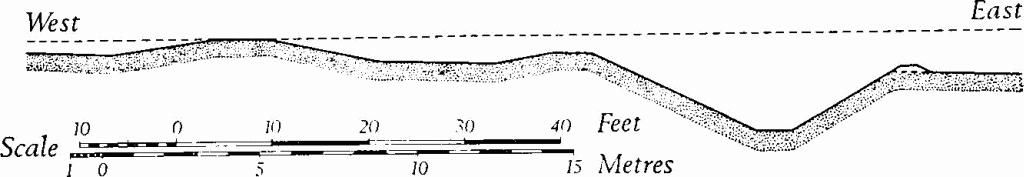
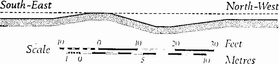
(14) Cross-dyke (90101854–90111886), near Hatt's Barn, lies across a ridge between 700 ft. and 800 ft. above sea-level and faces E.; it is cut by the modern road running S.W. from Win Green in Wiltshire. South of the road the dyke runs S.S.E. for 175 yds. and then, in Hatt's Copse, turns to run S.S.W. for a further 200 yds.; it ends halfway across a shallow combe falling south-eastward. North of Hatt's Copse the earthwork comprises a ditch some 8 ft. deep and 30 ft. across, with a modern hedge-bank along the W. edge. A main bank 28 ft. across and up to 2½ ft. high lies some 25 ft. back from the W. edge of the ditch, but it extends S. for only 100 yds. and ends immediately inside the copse. The ditch continues, but towards the S. end of the copse it is blocked by a modern track and cut into by a pond. Further S. the ditch reappears on a smaller scale, about 15 ft. across and up to 4 ft. deep, and disturbed by digging; it has no bank, and lynchets on either side of it have accentuated the profile. On the N. side of the modern road, as noted by Sumner (Cranborne Chase, 66), the dyke appears to have continued as far as the shoulder of the slope to a very steep-sided combe. This section, now followed by the boundary between Compton Abbas and Melbury Abbas, is marked by a large hedge-bank, 15 ft. across and up to 4 ft. high, with a slight dip which probably marks the line of the ditch along the N.E. side.
(15) Dyke (90721601–91071625), near Deadman's Coppice, 1 mile S. of the village, extends from S.W. to N.E. obliquely across a S.-facing slope, between 550 ft. and 600 ft. above sea-level. It is some 480 yds. long, but it has been almost entirely obliterated by cultivation and trackways, except at the S.W. end where, in Deadman's Coppice, it is well-preserved for a length of some 80 yds., comprising a bank 15 ft. across and 1½ ft. high, with a ditch 16 ft. across and 2 ft. deep on the N.W. side.
(16) Dyke (91931675–92531725), in Mudoak Wood, extends from S.W. to N.E. for some 900 yds. across a low spur and a dry valley, at altitudes between 500 ft. and 600 ft. above sea-level; at its N.E. end it crosses the boundary with Wiltshire. The earthwork is best preserved for a distance of about 300 yds. in Mudoak Wood, where the bank is 20 ft. across and 2 ft. high, and the ditch, lying along the N.W. side of the bank, is 25 ft. across and 2½ ft. deep. A so-called 'barrow' on the line of the dyke at 92131698 is almost certainly part of the bank. Between Mudoak Wood and the county boundary the dyke has almost been destroyed by ploughing, but it is clearly earlier than the agger of the Roman road, which crosses it. At the S.W. end the earthwork has been disturbed by a track.
Monuments (17–18), Round Barrows
A round barrow, from which bones were recovered when it was removed during the 19th century, lay near 897168 on the boundary with Fontmell Magna (Watson, op. cit., 3, 20). A group of four small mounds N. of Well Bottom (91631670 centre), which Watson thought were barrows, are probably the remains of the lynchetted angles of 'Celtic' fields, elsewhere destroyed by more recent cultivation. Apart from these, two barrows are noted:
(17) Bowl (91511628), S.W. of Well Bottom on a S.E.-facing slope, lies at about 560 ft. above O.D.; diam. 45 ft., ht. 1½ ft.
(18) Bowl (91531629), immediately N.E. of (17); diam. 30 ft., ht. 1 ft.
Undated
(19) Pond (91291780), at the centre of the village (Plate 32), is circular and some 40 yds. in diameter. Of its origin nothing is known; it may be partly natural, but enlarged artificially, perhaps in Roman times (Crawford, Antiquity, II (1928), 184).